
Photo of the Day

A Natural History of Conewago Falls—The Waters of Three Mile Island
As they travel between coastal wintering ranges and breeding territories in Canada and Alaska, vast numbers of shorebirds pass through the lower Susquehanna region each spring and fall—though few stop here to rest, feed, and provide us with an opportunity to observe them. Prior to the construction of man-made dams and other alterations on our lotic (flowing) waterways including the river, shorebirds took advantage of lateral bars, stream deltas, and other alluvial deposits as places to loaf and re-energize. Before they were drained and filled, some of the valley’s wetlands probably included sparsely vegetated flats where shorebirds could drop in for a brief visit. Previous to their extirpation from our region, North American Beavers were the primary providers of quality habitat for shorebirds and other migrating waders on our lotic waters. Their widespread network of dams, pools, and marshes maximized floodplain function by keeping streams thoroughly connected to their wetlands, nurturing plant communities that not only provided food and shelter for the beavers and other wildlife, but provided superb buffering against erosion while protecting against sediment and nutrient imbalances in lower Susquehanna waterways.


So how did this happen? How did the North American Beaver become a keystone species—an animal upon which the majority of other life forms within its ecosystem are so reliant? Well, it’s largely due to the fact that our beavers aren’t particularly fond of a constant stream of noise. More specifically, they don’t like the sound of running water in places where they intend to build and maintain a lodge. And so, as they begin to place sticks, mud, limbs, stones, and other materials within a noisy riffle on a stream, they create a dam, and behind it a pool—a pool that is particularly advantageous for protecting their home and providing a means of conveyance for their construction materials and food supplies.


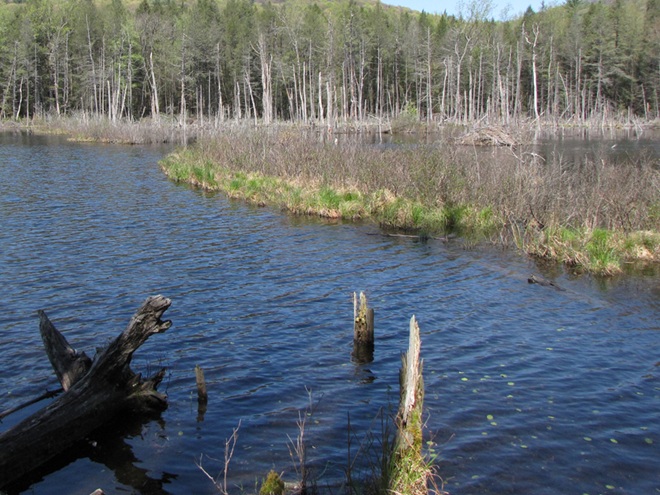


While North American Beavers have returned to the region, most live as “bank beavers”, residing in the river and larger creeks of the valley where they excavate shelters among the roots of Black Willows and other shoreline trees and shrubs. Floodplain encroachment, legacy sediment deposits, and just plain human intolerance have all conspired to prohibit North American Beavers from performing their magic on smaller local streams. For migrating shorebirds, this continued absence of beaver dam ecosystems has turned much of the lower Susquehanna valley into “flyover country”. Those travelers that do stop to rest and feed concentrate at the few favorable locations such as the lateral bars and the hydroelectric dam-created delta at the Conejohela Flats on the river in Lancaster County. But centralization has its drawbacks. Migrants spending time at concentration points may have a greater chance of contracting and spreading disease. Protracted heavy foraging can degrade these habitats. And over time, features such the lateral bars and delta deposits, including those on the Conejohela Flats, transition into other habitats—riparian forests. A more widespread selection of favorable stopover points for shorebirds, waders, waterfowl, and other migrants is certainly desirable.
IMITATION IS THE SINCEREST FORM OF FLATTERY
Until public sentiment sways in favor of the North American Beaver, wildlife managers are mimicking some of the attributes of their sound-inspired installations.

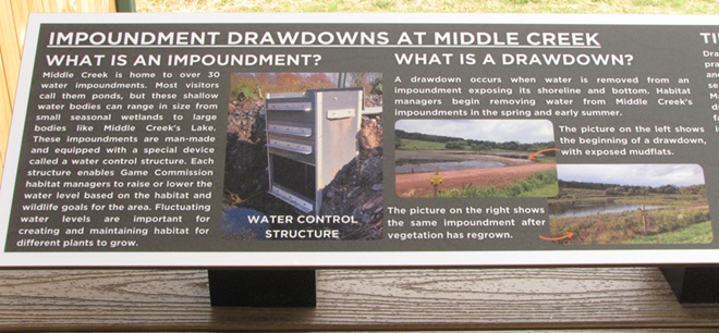
Shallow-water conservation impoundments designed, constructed, and managed for migratory waterfowl and waders including shorebirds are not what we typically refer to as ponds—though they are lentic (still) waters. Similar shallow freshwater impoundments at our National Wildlife Refuges are referred to as pools by the United States Fish and Wildlife Service, but smaller versions like this example at Middle Creek very closely resemble the prairie potholes created by glacial scour in the north-central United States and adjacent portions of Canada. Many populations of migratory birds are familiar with pothole ecosystems and, like the beaver pools and marshes, have relied upon them as waypoints along their journeys for centuries.


You’ve heard the line, “If you build it, they will come.” Well, it’s true. Here is a sample of the activity witnessed during the past two weeks at the new impoundment completed just several months ago at Middle Creek Wildlife Management Area along the tour route just beyond the “Stop 3” overlook.


Species of wildlife in addition to shorebirds and waterfowl have already found the new impoundment favorable…


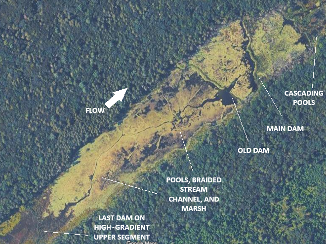
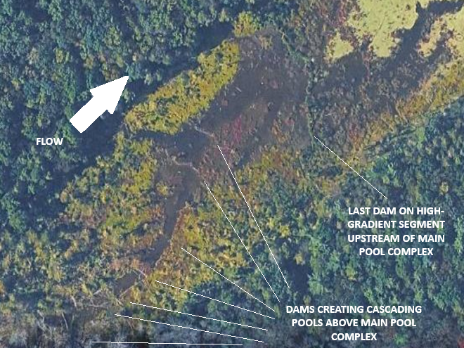
Managing saturation levels in shallow-water impoundments to resemble the seasonal variations in beaver pool and marsh systems can create lush growth and wildlife-rich environments. Take a look at some images from a project in a headwaters area of a tributary to Conewago Creek (west)…


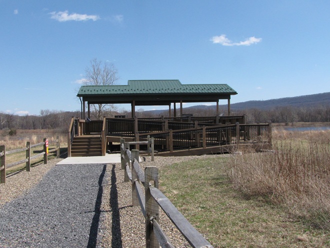
So that you can relax while observing the comings and goings at a pair of the lower Susquehanna valley’s man-made impoundments, the Pennsylvania Game Commission has erected two viewing pavilions for public use on its lands…


During the next two weeks, the exodus of migrating shorebirds now staged and feeding upon Atlantic Horseshoe Crab eggs on Delaware Bay will commence. During the evening of their departure from the bay, many of these birds cross portions of the Lower Susquehanna River Watershed, particularly east of the river. Stormy weather and other climatic conditions may force some of them to seek a place to put down temporarily, so keeping a close eye on the new pothole-like impoundment at Middle Creek may be a prudent move. After that, waders known as “post-breeding wanderers” can show up at any time. Then, beginning as early as late June, shorebirds begin moving south on a migration that can provide us with viewing opportunities into September and beyond. See you out there!
Pretty pictures…


We’ll have more on the Western Cattle Egrets and other interesting migrants at Middle Creek in an upcoming post. Check back soon!


The majority of floodplains in the Lower Susquehanna River Watershed are, to put it mildly, dysfunctional. They are frequently disconnected from the lotic (flowing) streams and rivers that created them and are no longer capable of absorbing, purifying, and infiltrating high water during rain and snow-melt events. They are an ongoing source of nutrient and sediment pollution that impairs both our local waterways and Chesapeake Bay. For the plant and wildlife species that rely upon them for survival, their loss has been catastrophic.
Mill dams once impounded nearly every mile of low-gradient streams in the lower Susquehanna region. During the century or more of their existence prior to the implementation of soil conservation practices during the 1930s, sediments consisting mostly of nutrient-loaded clay, silt, and sand eroded from sloped terrain in storm runoff and accumulated behind these dams, filling many to the brim with mud—six, eight, ten, sometimes twelve feet deep! As the dams fail or are removed, the stream is left channelized, incising a path through a floodplain choked with these “legacy sediments”.


For a closer look at the Swarr Run renewal, including early map and aerial photograph views of the site, take a peek at this synopsis illustrating phase one of the project as presented to the North American Association of Wetland Managers by Justin Spangler of LandStudies, designers of the restoration. While perusing the material, be sure to review the significant reductions in nutrient and sediment loads discharged from these sites following the restoration work.


Have an impaired stream and a floodplain full of legacy sediments on your land or in your neighborhood? Consider encouraging your municipality, volunteer watershed group, or county conservation district to investigate the possibilities of planning and installing one of these projects. They’re a great enhancement for recreational fisheries, a private refugium, or a community-owned passive park system. Funding assistance may be available, particularly when regulatory or conservation goals can be met by completing restoration.
Clean rainwater flowing from the roofs of our homes and other buildings is a precious resource that is more often than not directed as quickly as possible into streets and storm drains to become contaminated runoff capable of polluting streams and aggravating flooding conditions. The prudent property steward will manage rainfall as the treasured commodity that it is—retaining on site as much of it as possible.
Whether you happen to be obtaining your domestic water from a community distribution system or from a private well, infiltrating the rain that falls on your roof directly into the soil is a good way to make sure it helps recharge the groundwater stored in the aquifer—banking it for future use.
Better yet, rain barrels provide a means of intercepting, storing, and dispensing a share of the precipitation from your downspouts before it is discharged into the ground. Water from rain barrels can be drained to hydrate garden plants, rinse the patio, wash the dog, or, in the event of an emergency, fill the need for non-potable uses that include bathing and flushing toilets. For potable applications such as cooking, drinking, and brushing teeth, roof water must first be filtered and disinfected.

Here at susquehannawildlife.net headquarters, our goal is “no net runoff” from our little urban parcel. We use three rain barrels to catch discharge from the spouting system, then direct the overflow into three different management configurations.
RAIN GARDEN


STOCK TANK PLANTER

THE GARDEN POND/POOLS


")

Why not give roof water management a try on your property? It’s a great project for exercising your ingenuity and creativity while doing something truly beneficial for the watershed within which you reside. Best of all, it’s really not that expensive to get started.

The dynamics of water’s storage and movement on earth, as well as its transitions through the primary states of matter—gas, liquid, and solid—are known as the water cycle. Understanding how life-supporting water progresses through the global biosphere can provide each of us with a greater appreciation of how fragile a resource clean water is in the presence of 8.3 billion wasteful and polluting humans.
This graphic created by the United States Geological Survey illustrates many of the components of the water cycle’s complex processes. Have a look…

For a PDF version which includes a more detailed description along the bottom margin, click here. We like it so much, we’ve added it to this webpage’s sidebar for future reference.
If you’ve visited Middle Creek Wildlife Management Area anytime during the past month, you may have noticed quite a bit of activity around the large pole-mounted nest boxes placed out in the open fields.


LEARN HOW LAND MANAGERS UTILIZE PRESCRIBED FIRE
This coming Saturday, April 18, 2026, beginning at 10 A.M. (rain date April 25), the Pennsylvania Game Commission is hosting a “Prescribed Fire Festival” at Middle Creek Wildlife Management Area. Be certain to come out to the visitor’s center at 100 Museum Road, Stevens, PA, for this event. Land managers will be there to answer questions and to explain the planning and preparations involved in overseeing a prescribed burn. There will be guided walks of habitats preserved using fire of varying intensities. You’ll see the equipment and protective clothing used by certified personnel to administer a live prescribed fire burn right before your eyes. Then you can have lunch—food trucks will be available on site.

After the burn demonstration, why not go for a walk or drive around the refuge. You can take note of how grassland and early successional plant communities are responding to previous doses of prescribed fire…


And how the grassland animals respond as well…


The fate of an avian predator such as a kestrel lies at the mercy of the fate of its quarry. Because, you see, the sun’s energy, after being converted to chemical energy by photosynthesizing plants, flows upward through the trophic levels of the food chain—herbivores (primary consumers) such as rodents and insects to carnivores (secondary and tertiary consumers) including kestrels. Grasslands, when abundant and diverse, are correspondingly abundant and diverse with small mammals and insects and will therefore support thriving populations of American Kestrels and other predators. These secondary and sometimes tertiary consumers fulfill a role in cultivating healthier populations of their prey—the primary and secondary consumers in the food web—as a balanced component of a flourishing grassland ecosystem. Sparse and fragmented grasslands, on the other hand, beget negligible small mammal and insect populations, are stricken with broken food webs, and champion few if any American Kestrels or other predators. If the land it occupies is neat, tidy, manicured, exploited, or sprayed sterile and dead, the energy flow cycle of the ecosystem is dead as well. There’s nothing animal introductions, reintroductions, rescues, culling, stocking, or harvesting can do about it, because in the end, it’s all about the habitat.

We frequently perceive all waterfowl migration to be synchronized with the conspicuous movements of familiar species like Snow Geese, Tundra Swans, and Canada Geese—big flights coming south in October and November, then a return to the north in late February and March. And we’re all quite aware of the occurrence of large gatherings of some of these migrants while they make stopovers on some of our largest lentic (still) waters—the man-made lakes and reservoirs created by damming local streams. But did you know that there are populations of colorful waterfowl with dynamic migrations that extend throughout the winter and early spring with movements that are often continuous. Under favorable conditions, these birds favor the lotic (flowing) waters of the river and its larger tributaries as they transit the lower Susquehanna valley. That’s because unpolluted lotic freshwater ecosystems support a greater diversity of plants and animals than lentic waters, and therefore offer more opportunities for hungry migrating waterfowl to find food. Let’s have a look at some of the species that visit the river during their seasonal journeys…


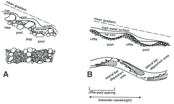


Prior to the nineteenth century, the low-gradient flow regime of the river both above and below the riffles at Chiques/Chickies Rock (lower right on map) created prime wildlife habitat. The natural accumulations of nutrients and substrates carried into and through the lotic waterway’s pools and riffles were cycled into an ideal growing medium for extensive mats of American Eelgrass and other aquatic plants. This underwater forest hosted a seemingly endless abundance of invertebrates and fishes (both resident and migratory)—supporting a variety of consumer species including various populations of humans. But soon after the mass clearing of much of the watershed’s land for farming and lumber, the mill ponds created by dams constructed on streams to power saw and grain mills became brimful with sediments eroded from the unprotected ground. During storm events, torrents of these sediments then flowed full bore toward the Susquehanna, and began accumulating in the low-gradient segments of the river.


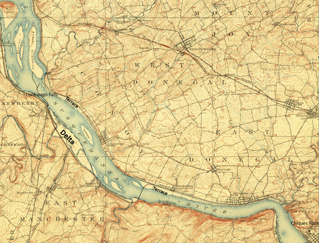
Despite being located in the transfer zone, the lower Susquehanna has become a significant depositional zone along much of its length, mostly courtesy of the placement of sediment-trapping man-made dams.
Following construction of the mill dams and ponds on nearly every mile of the lower Susquehanna’s low-gradient tributary streams, enterprising parties moved on to the river. The first significant spans were constructed using wide timber cribs filled with large rock. They were placed to create water deep enough to allow canal boats to cross the Susquehanna at both Clark’s Ferry at the mouth of the Juniata River in Dauphin County and at Columbia/Wrightsville. These dams also diverted water into the newly excavated canals—the Pennsylvania Eastern Division Canal (completed in 1833) which followed the river’s east shore from Clark’s Ferry to Columbia, and the Susquehanna and Tidewater Canal (completed in 1840) along the west shore from Wrightsville to Havre de Grace, Maryland. Placement of these sediment-trapping man-made dams began a process of converting vast mileage of the lower Susquehanna from a transfer zone into a deposition zone. In addition, layout of the canals and locks followed the contours along the base of the riverside ridges, seriously altering most of the alluvial terrace wetlands that the river had created as a feature of its floodplain during the post-glacial period.
Construction of the canal dams was just the beginning. During the twentieth century, more massive dams would be added to the main stem of the river for hydroelectric energy production at York Haven, Safe Harbor, Holtwood, and Conowingo. Upon their completion, the days of unassisted anadromous fish migrations were over. On both the river and its tributaries, smaller dams including dangerous low-head dams maintain water levels for boating and recreation. They too create current-diminishing, pseudo-lentic waters that blanket the lotic riffle and pool substrates with polluted sediments.
MAN-MADE DAMS TURN LOTIC WATERS INTO UNFLUSHED TOILETS


Dredging of sections of the lower Susquehanna for spilled, discarded, and washed-out anthracite coal sediment went on for nearly 100 years and was a particularly active enterprise in the Harrisburg area and in Lake Clarke until 1973. The recurrent substrate disturbances that accompanied waste coal recovery in these segments of the river repetitively damaged habitat for benthic life and may have been the catastrophic factor leading to the extirpation of two species of freshwater mussels: the Eastern Lampmussel (Lampsilis radiata) and the Dwarf Wedgemussel (Alasmidonta heterodon).


DID YOU KNOW that a dairy cow produces about 80 pounds of waste (excrement and urine) every day?
DID YOU KNOW that a horse produces about 50 pounds of waste (excrement and urine) every day?
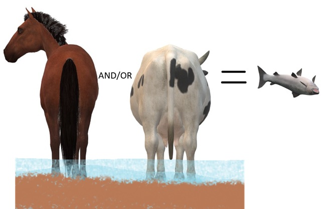
DID YOU KNOW that a human produces about 3 to 4 pounds of waste (excrement and urine) every day? The exceptions, of course, are those who continue to insist that raising farm animals in and alongside a body of water is okey-doke—a harmless practice. These individuals tend to retain the former constituent of human waste and are thus full of it.


DID YOU KNOW that even before the landscape was cleared for farms and a supply of timber, and before mill dams on local creeks began accumulating soil runoff from the consequently barren hillsides, all the North American Beavers, the keystone species of lower Susquehanna stream ecology, were killed and sold to make hats? It’s no wonder things are fubar!


Our first big wave of northbound migrants has come and gone, but don’t despair; for spring is still a few days away, and we have yet to reach the end of the beginning …


With the arrival of the spring equinox, longer periods of daylight will accompany the return of many more species. Be sure to get outside, then have a look around.
Step outside, take a listen, and look up. A substantial northward movement of early migrants is, at this writing, underway across the lower Susquehanna basin—primarily in the skies within five to maybe ten miles of the river corridor. Within the last hour, we witnessed a steady parade of geese, swans, and blackbirds in the skies above the headquarters garden. These are not birds that are staging or are in the midst of a stopover here during their journey north. They are instead flocks taking advantage of favorable conditions to make a big jump from Chesapeake Bay and adjacent areas of the Atlantic Coastal Plain into territory to our north and northwest that was just two weeks ago in the middle of a deep freeze. Compared to the slowpokes whose northbound movements are a bit more cautious, the shared determination of these birds to get to the nesting grounds first may be advantageous for their breeding success.


Winds from the southwest are forecast for the coming couple of days, so the movements could continue. Head outside, enjoy the weather, and look up.
Eastern Chipmunks are familiar mammals of our deciduous forests and wooded neighborhoods. They are surprisingly solitary and territorial, defending their well-concealed underground excavations vigorously to protect them from would-be intruders—including other chipmunks. Their individual effort to stockpile a cache of seeds, nuts, and other non-perishable foods during the autumn will largely determine whether or not they survive winter’s worst.


In case you haven’t already heard, the Snow Geese are at last filtering north from the Atlantic Coastal Plain to congregate at the Pennsylvania Game Commission’s Middle Creek Wildlife Management Area in Lancaster and Lebanon Counties.


Just a reminder—there’s still time to order trees and shrubs from your local county conservation district’s annual sale, but you need to act soon…
Cumberland County Conservation District 48th Annual Tree Seedling Sale
Order by Friday, March 20, 2026
Pick Up on Thursday, April 16, 2026, or Friday, April 17, 2026
Dauphin County Conservation District Seedling Sale
Order by Monday, March 16, 2026
Pick Up on Thursday, April 23, 2026, or Friday, April 24, 2026
Franklin County Conservation District Tree Seedling Sale
Order by Tuesday, March 17, 2026
Pick Up on Thursday, April 23, 2026
Huntingdon County Conservation District Tree/Seedling Sale
Order by Friday, April 3, 2026
Pick Up on Thursday, April 16, 2026, or Friday, April 17, 2026
Lancaster County Conservation District Annual Tree Seedling Sale
Order by Friday, March 6, 2026
Pick Up on Friday, April 10, 2026
Lebanon County Conservation District ALL NATIVE! Tree & Plant Sale
Order by Monday, March 2, 2026
Pick Up on Friday, April 17, 2026
Mifflin County Conservation District Tree Sale
Order by Friday, March 6, 2026
Pick Up on Wednesday, April 15, 2026, or Thursday, April 16, 2026
Order by Saturday, March 21, 2026
Pick Up on Saturday, May 2, 2026
Snyder County Conservation District Tree Seedling Sale
Order by Monday, March 30, 2026
Pick Up on Wednesday, April 15, 2026
York County Conservation District Seedling Sale
Order by Sunday, March 15, 2026
Pick Up on Thursday, April 16, 2026
If maybe you would like to order trees but you’re not quite ready to put them in the ground, why not pot them up and start your own plant nursery. It’s a great way to build an inventory of hardy stock for planting around your own property or for use in community or civic conservation projects.


During winter’s harshest conditions, one must frequently marvel at the methods various forms of wildlife have to survive. Take a look at some of the animals we found using their life-sustaining adaptations to find food amidst the snow-covered landscape and bitter cold air.


For those of you who may be wondering if there are Snow Geese at Middle Creek Wildlife Management Area, the answer is yes—just one!

So where are the thousands of Snow Geese we’ve grown accustomed to seeing during recent decades as they gather at the refuge in February while preparing to fly north for the summer?
")
")
It looks like the worst of the cold may be behind us. With temperatures trending upwards during the coming days and weeks, some species of wildlife will soon find their search for food made a whole lot easier.


With another round of single-digit and possibly sub-zero temperatures on the way, birds and other wildlife are taking advantage of a break in the extreme conditions to re-energize. During the past day, these species were among those attracted to the food and cover provided by the habitat plantings in the susquehannawildlife.net headquarters garden…


For overwintering birds and other animals, finding enough food is especially difficult when there’s snow on the ground. And nighttime temperatures in the single digits make critical the need to replenish energy during the daylight hours. Earlier this afternoon, we found these American Robins seizing the berry-like cones from ornamental junipers in a grocery store parking lot. It was an urgent effort in their struggle for survival.


County conservation district offices will soon be taking orders for their spring tree sales. Be sure to load up on plenty of the species that offer food, cover, and nesting sites for birds and other wildlife. These sales are an economical way of adding dense-growing clusters or temperature-moderating groves of evergreens to your landscape. Plus, selecting four or five shrubs for every tree you plant can help establish a shelter-providing understory or hedgerow on your refuge. Nearly all of the varieties included in these sales produce some form of wildlife food, whether it be seeds, nuts, cones, berries, or nectar. Many are host plants for butterflies too. Acquiring plants from your county conservation district is a great opportunity to reduce the amount of ground you’re mowing and thus exposing to runoff and erosion as well!
It all started rather innocently as a typically cold early January with sheets of ice covering the river and with soils on the lands in the remainder of the lower Susquehanna watershed frozen solid. Then came the “Blizzard of ’96”, blanketing much of the valley with between 20 and 30 inches of wind-driven snow.

In affected areas of Pennsylvania, Governor Tom Ridge closed all state roads for the duration of the snowfall event. Many would remain closed for much of the following week as drifting hampered exhaustive efforts to get impassable routes open.


Just as the recovery entered its second week, a change in the weather pattern took hold as milder air and spring-like rains hastened the melt. Clogged by snow often several feet in depth, storm sewer inlets and other drainage features failed to collect the runoff. Street and urban flooding became widespread. Some buildings, particular those with large flat roofs, experienced structural damage due to any remaining snow soaking up the additional weight of the rain. As local creeks swelled to stain snowy meadows brown, attention shifted to the icy river.
On the Susquehanna, rising waters started moving ice into accumulating piles of car-sized chunks behind dams and at choke points along the river’s course. During warmer weather, stream gauges provide a depth of water reference known as a stage (measured in feet) that corresponds to a rate of flow passing the gauge site (measured in cubic feet per second). On occasions when ice and debris block river channels during winter, these readings can fluctuate wildly and the relationship between stage and flow can become dubious. When the water is running ice-free at Harrisburg for example, a gauge reading of about 11.1 feet is indicated when the river flow rate is approximately 162,000 cubic feet per second. But due to its impact on the capability of the river channels to pass water, the presence of slow-moving and jammed ice can cause rapid and sometimes unpredictable variations in gauge readings, even when the flow rate remains steady. Impaired by an ice jam at the gauging station or just downriver, a flow of 162,000 cubic feet per second could lead to a stage measurement significantly higher than 11.1 feet, and the area of adjacent floodplain inundated by rising waters will increase to a corresponding degree. Conversely, a jam upstream of the gauging station could cause the reading to drop below 11.1 feet—at least temporarily—then look out, a dangerous surge could be forthcoming!
At Harrisburg, the ice jam behind the Dock Street Dam in January, 1996, caused devastating flooding in the city’s Shipoke neighborhood, on City Island, and in low-lying areas along the river’s west shore.

Downriver at Conewago Falls, ice jams behind the York Haven Dam and at several choke points within the riverine archipelago that extends from Haldeman Island to Haldeman Riffles in Lancaster County would be relieved as the river crested there during the afternoon of January 21st. The following photograph accurately relates the scene, minus the stench of mammalian feces and petroleum emanating from the polluted water of course.

You may find this hard to believe, but during the colder months in the lower Susquehanna valley, gulls aren’t as numerous as they used to be. In the years since their heyday in the late twentieth century, many of these birds have chosen to congregate in other areas of the Mid-Atlantic region where the foods they crave are more readily available.
As you may have guessed, the population boom of the 1980s and 1990s was largely predicated on human activities. These four factors were particularly beneficial for wintering gulls…


So what happened? Why are wintering gulls going elsewhere and no longer concentrating on the Susquehanna? Well, let’s look at what has changed with our four man-made factors…

GULLS THIS WINTER
Despite larid abundance on the lower Susquehanna not being the spectacle it was during the man-made boom days, an observer can still find a variety of medium and large-sized gulls wintering in the region. We ventured out to catch a glimpse of some of the species being seen both within the watershed and very nearby.


For us, seeing a Glaucous Gull brought back memories of the last time we saw the species. It was forty-five years ago on New Year’s Day 1981 that we discovered two first-winter birds feeding on Gizzard Shad in open water on an otherwise ice-choked Susquehanna below the York Haven Dam powerhouse at Conewago Falls. Hey Doc Robert, do you remember that day?


As part of an update to our “Hawkwatcher’s Helper: Identifying Bald Eagles and other Diurnal Raptors” page, we’ve just added this chart for determining the age of the Bald Eagles you might observe on the lower Susquehanna River and elsewhere in coming weeks.

Bald Eagles in each age class often retain their fall appearance through much of the winter. However, beginning January 1st, each bird is reclassified into the next in the series of chronological plumage designations. Consequently, during the early part of the new year until a new generation of eagles is hatched in late winter and spring, there are no birds in our area designated “hatch-year/juvenile”. After fledging, these youngest eagles, the new generation of juveniles, often show little change in appearance until after their first birthday, by which time they are already classified as second-year/Basic I immature birds. For birds other than the new generation of hatch-year/juvenile eagles, the majority of the molt that produces their new autumnal appearance each year occurs during spring and especially summer, when food is abundant and the bird’s energy needs for purposes other than growing feathers are at a minimum. Hence, by the time fall migration rolls around, the next in the successive progression of plumage changes is evident. For more details and year-round images of Bald Eagles, check out our “Hawkwatcher’s Helper: Identifying Bald Eagles and other Diurnal Raptors” page by clicking the tab at the top of this page.

Wintering Bald Eagles are again congregating on the lower Susquehanna River, particularly in the area of Conowingo Dam near Rising Sun, Maryland. To catch a glimpse of the action earlier this week, we took a drive on U.S. Route 1 atop Conowingo’s impounding structure to reach Fisherman’s Park on the river’s west shore below the powerhouse.


 Bald Eagle")
 Bald Eagle")
 Bald Eagle")
 Bald Eagle")
 Bald Eagle")


To the delight of photographers at Conowingo, some of the eagles can be seen grabbing fish, mostly Gizzard Shad, from the tailrace area of the river below the powerhouse. But Bald Eagles are opportunistic feeders, and their feeding habits are similar to those of numerous other birds found in the vicinity of the dam at this time of year—they’re scavengers. Here’s a glimpse of some of the other scavengers found in the midst of this Bald Eagle realm…


Here are a few more late-season migrants you might currently see passing through the lower Susquehanna valley. Where adequate food and cover are available, some may remain into part or all of the winter…


