A Natural History of Conewago Falls—The Waters of Three Mile Island
Geology, Fossils, and More
Geology, Fossils, and More
The Rocks, their Formations, and Ancient Life
In the Triassic-Jurassic Gettysburg Basin
and Adjoining Strata of the Lower Susquehanna River Watershed
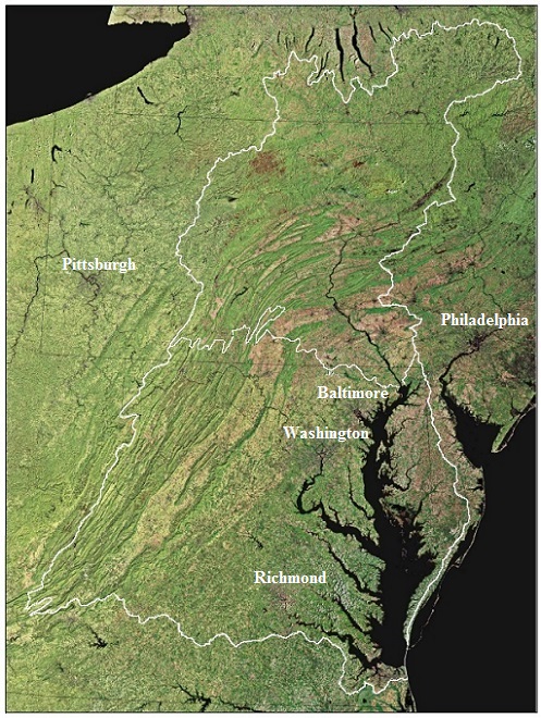
The Chesapeake Bay Watershed (outlined in white) encompasses 64,000 square miles of land and water. The Susquehanna River Watershed (north of the white dividing line) is the Chesapeake’s largest tributary system, draining an area covering 27,510 square miles. (Base image from United States Geological Survey-1997)
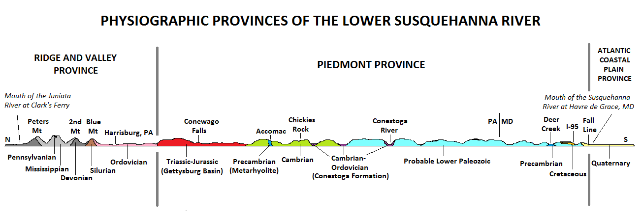
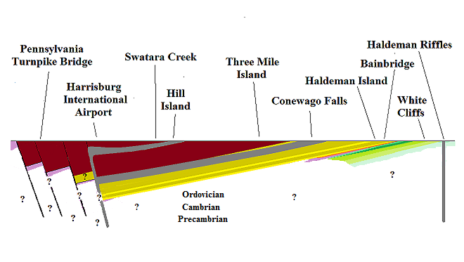
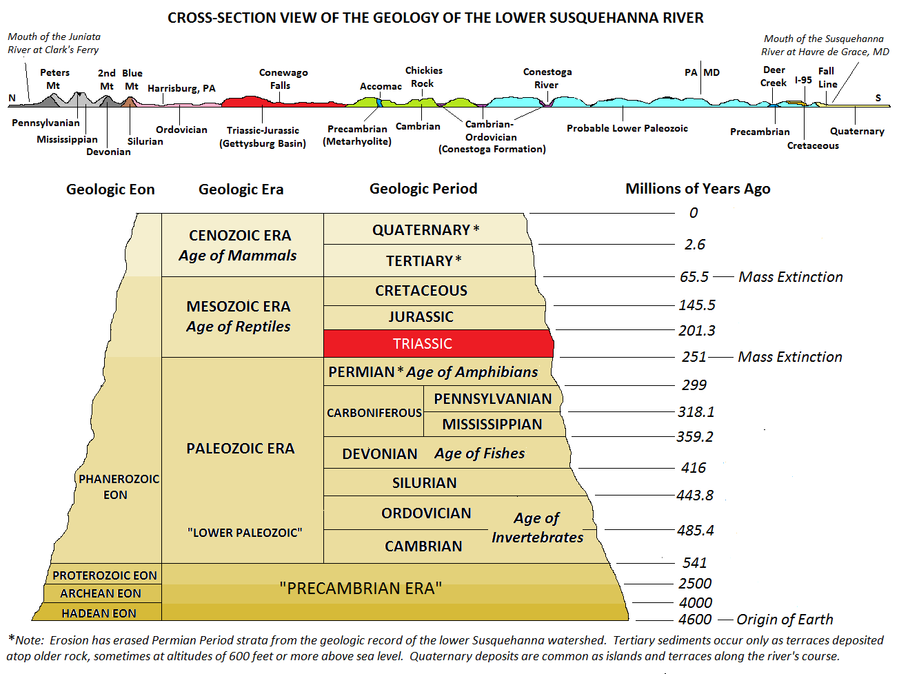
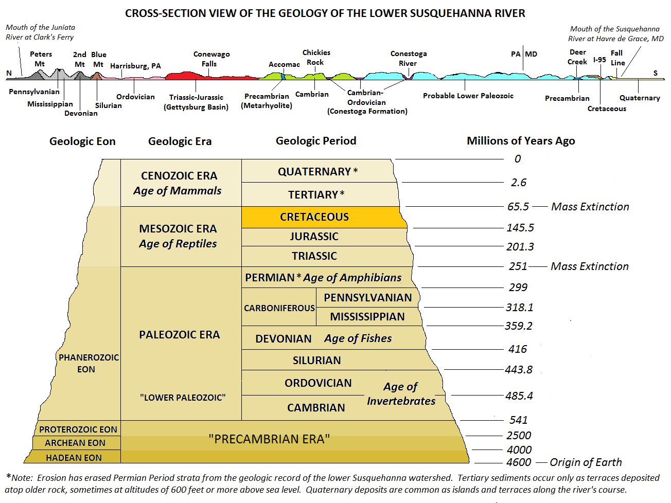
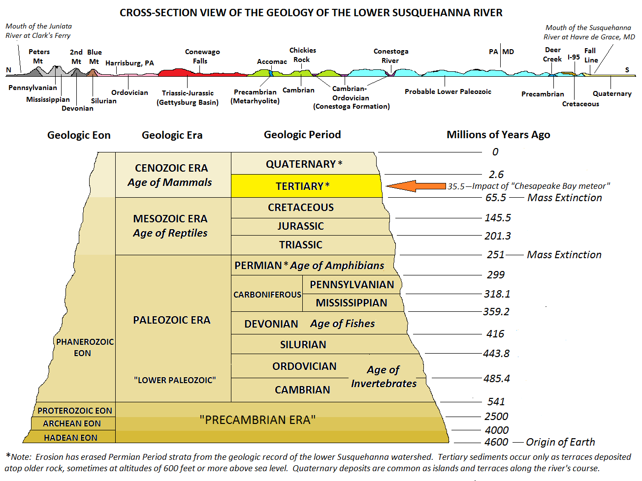
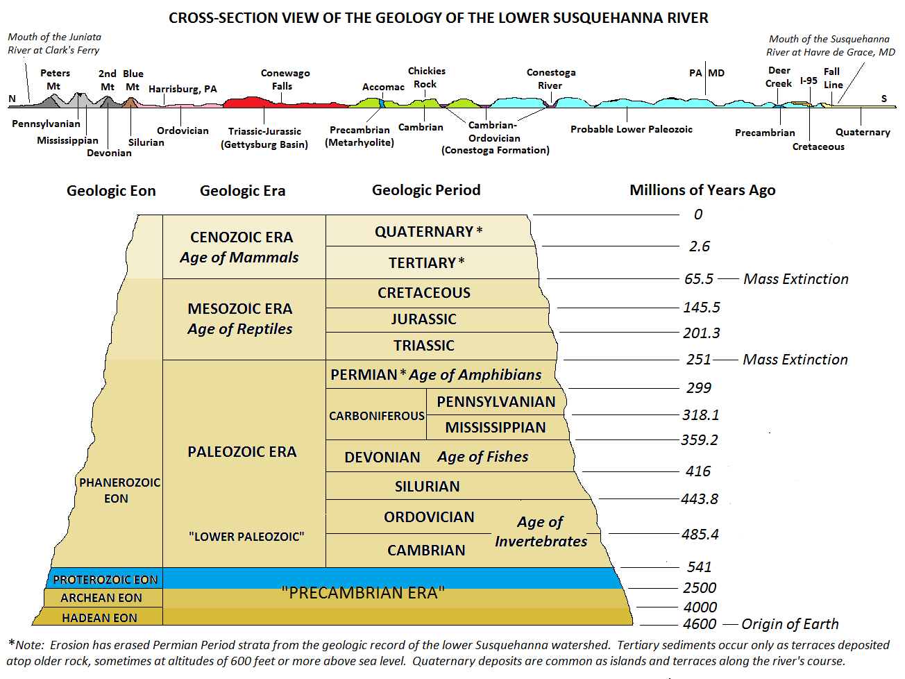
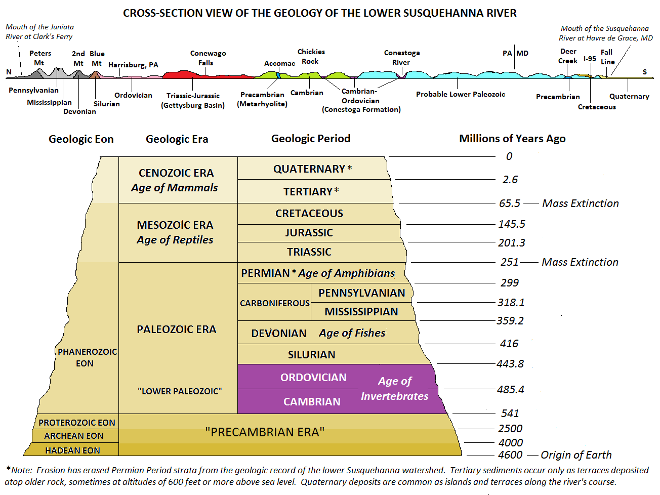
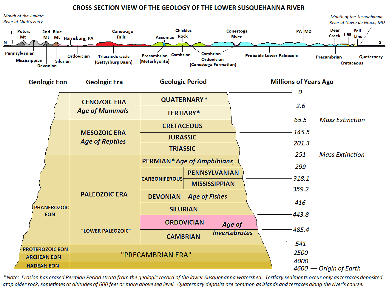
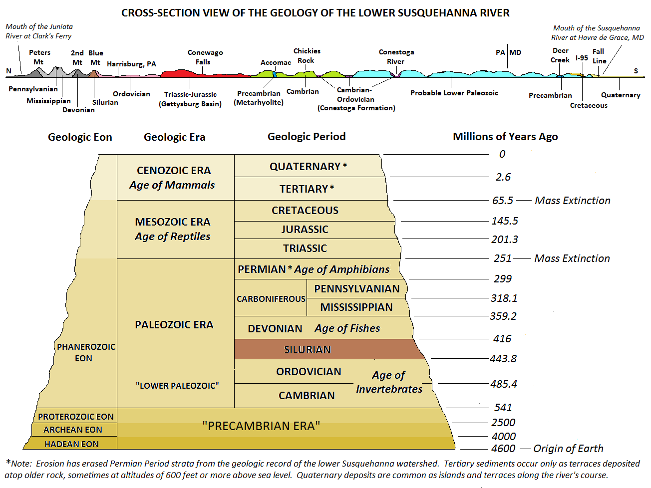
The path of the lower Susquehanna River cuts through bedrock that chronicles much of the last 550 million years or more of earth’s history. If one were to travel the Susquehanna from the mouth of the Juniata River at Clark’s Ferry downstream to Chesapeake Bay at Havre de Grace, Maryland, he or she would pass through surface formations composed of strata representing each of the geologic eras: the Precambrian, the Paleozoic, the Mesozoic, and the current Cenozoic.
The path of the lower Susquehanna River from the mouth of the Juniata River at Clark’s Ferry to Havre de Grace, Maryland, passes through strata from each of the four geologic eras.Cross-section sketch of the geology of the lower Susquehanna River. (Click image to enlarge)
Because dinosaurs frequently come to mind when the word “fossil” is mentioned, we”ll begin our look at the geology of the lower Susquehanna with the formation of the Gettysburg Basin, the last major tectonic shift in the landmasses of the region.
Since the Pennsylvanian and Permian Periods, the time when the collision of Africa and North America completed the assembly of supercontinent Pangaea and caused the thrust-faulting that created the Appalachian and Allegheny Mountains, the area that is today the Susquehanna River watershed has been in an extended cycle of nearly continuous erosion. This erosion has erased nearly every trace of sedimentary bedrock originating during the Mesozoic Era—the age of the dinosaurs. There are but two exceptions, the formations of the Triassic Gettysburg Basin and small Cretaceous Period deposits near the fall line at the mouth of the Susquehanna in Maryland.
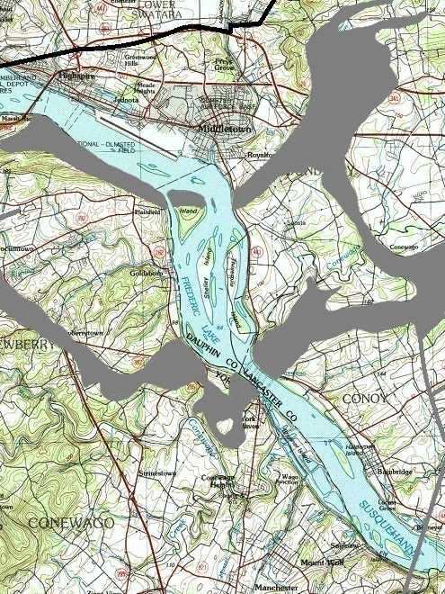
Within the Triassic Gettysburg Basin, Conewago Falls is a mile-long series of rapids surrounding Three Mile Island on the Susquehanna River in south central Pennsylvania’s Piedmont Province. Many nearby highways and tourist destinations are familiar to travelers. (Base image from United States Geological Survey Historical Topographic Map Collection-1984)
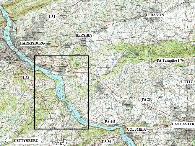
The outlined section of the map above (enlarged below) charts the course of the river through the Triassic Gettysburg Basin, home to some of the Susquehanna’s most interesting geologic features—each more than 190 million years old.
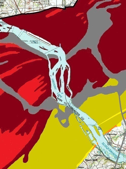
The Susquehanna River’s course through the Gettysburg Basin is shown here. Two Conewago Creeks, one to the west of the river and one to the east, drain a majority of the basin’s lands that lie within the Susquehanna watershed. Both enter the river at Conewago Falls. (Base image from the United States Geological Survey Historical Topographic Map Collection-1984)
THE GETTYSBURG BASIN’S NEWEST ROCK
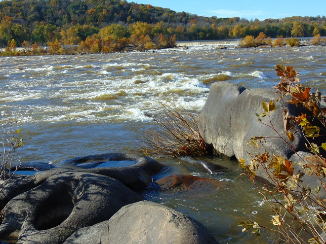
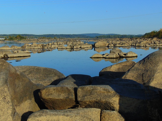
Perhaps the basin’s most familiar formations are composed of diabase, the erosion-resistant igneous bedrock of Conewago Falls and its Pothole Rocks. These formations, once subterranean in the rift valley/basin, are today the foundation of many of the upper Piedmont Province’s most conspicuous hills and ridges. In Pennsylvania, Triassic diabase, colloquially known as “ironstone”, is the most recent of the remaining rock formations in the Lower Susquehanna River Watershed.
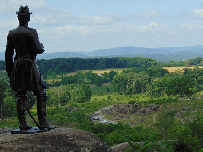
Through the mid-nineteenth century, Conewago Falls was the Gettysburg Basin’s most renowned landmark. The name Conewago is probably derived from “Ganowungo”, meaning “at the rapids”. The Iroquois called the falls “Washinta”, a shortened version of the Mohawk word “Tawasentha”, meaning “waterfall”. The Iroquois claimed the land along the Susquehanna south to Washinta, entrusting it to the governor of New York in 1684. He sold the land to William Penn so that the trees could be cut down and it could be turned into part of a subdivision called “Pennsylvania”, meaning “Penn’s Woods”. The impassable falls were familiar to European colonists attempting to travel and trade on the river. Largely due to the presence of Conewago Falls, the Susquehanna is the longest river in the United States without commercial boat navigation.Following the Battle of Gettysburg in 1863, diabase features that played a topographical role in the Army of the Potomac’s victory over the Army of Northern Virginia became more familiar than Conewago Falls as landmarks in the Gettysburg Basin. The Triassic diabase outcrop known as Little Round Top (foreground) served first as a lookout, then as an anchor point for the fishhook-shaped Union position which extended north along the diabase rise known as Cemetery Ridge, site of the repulse of “Pickett’s Charge”, the ill-fated Confederate attack launched on the third and final day of battle. Monuments, including the prominent Pennsylvania Memorial, can be seen in the distance along the portion of Cemetery Ridge known as the “High Water Mark” of the rebel invasion. The “Precambrian Era” hills of South Mountain can be seen in the distance.Devil’s Den, the outcrop of diabase boulders in the valley below Little Round Top, was the scene of fierce fighting on the second day of the Battle of Gettysburg. After occupying them during the fight, Confederate sharpshooters remained among the rocks taking aim at Union officers and soldiers on the summit above. Plum Run, often called Bloody Run during the years after the battle, drains the valley below Little Round Top to the Potomac River. The battlefields at Gettysburg lie just within the Potomac watershed, while those areas immediately to the north and east lie within the Susquehanna basin and are drained by Conewago Creek (west) to the river at Conewago Falls.
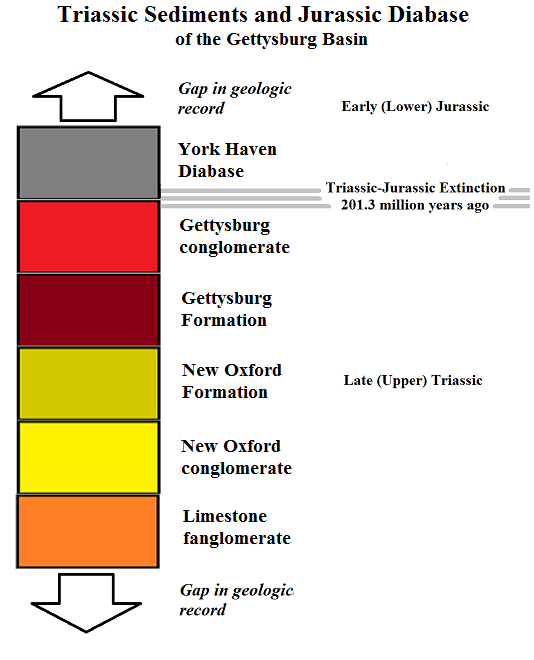
Note: Though considered to be components of the Triassic Gettysburg Basin, diabase formations, and possibly some of the redbed sediments, using the most current timeline, are now placed in the Jurassic Period (defined as 201.3 to 145 million years ago). For this reason, you may see terms including “Jurassic diabase” and “Triassic-Jurassic Gettysburg Basin” in use with increasing frequency.
Approximately 230 million years ago, as the supercontinent Pangaea began separating (a process that would, in time, divide Africa from North America) numerous rift basins formed along an arc paralleling the present-day Atlantic coast of the United States. As they subsided, the majority of these new valleys filled with sediments that eventually consolidated into new rock formations—then they stopped sinking and stabilized. The exception, the rift associated with the Mid-Atlantic Ridge, is still opening in the center of the Atlantic Ocean as the African and North American continents continue to creep apart at a rate of one to two inches every year.
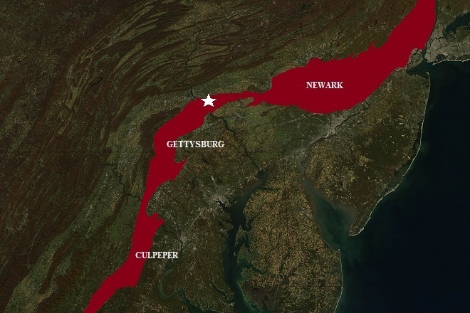
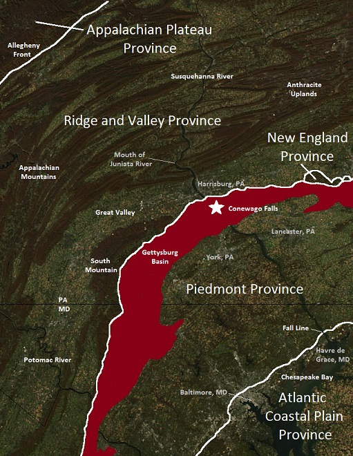
Pangaea separates, 230 million years ago to present. (Public Domain image)The Triassic rift valleys of the Piedmont Province in the present-day Chesapeake Bay watershed have their origins in the preliminary stretching of the lithosphere (the earth’s rigid crust) that eventually led to the tectonic separation of supercontinent Pangaea and the formation of the Atlantic Ocean. This series of three basins extends southwest from the Palisades on the Hudson River to central Virginia. Each subsided along a border fault on its present-day inland side and hinged downward from its seaward side. Collectively, the three basins are known as the Newark Supergroup. (Base image from NASA Earth Observatory Collection)White lines divide the physiographic provinces of the lower Susquehanna and adjacent watersheds. The area known as the Piedmont Province includes the Triassic rift basins of the Newark Supergroup and the much older lower Paleozoic and Precambrian formations that extend seaward to the fall line and the Atlantic Coastal Plain Province. (The “Northeast Megalopolis” parallels the border between these two provinces and appears as a gray line of cities and highways along a northeast to southwest line in this and the previous image). Except for a small spur of the New England Province known as the Reading Prong, the Ridge and Valley Province borders the entirety of the inland side of the segment of the Piedmont Province shown here. The star marks the location of Conewago Falls. (Base image from NASA Earth Observatory Collection)A cross-section view of the path of the lower Susquehanna River through the Ridge and Valley, Piedmont, and Atlantic Coastal Plain Provinces. (Click image to enlarge)Hypothetical cross-section views (not to scale) of the development of the Gettysburg Basin half-graben. The stretching of the earth’s crust caused existing bedrock to begin subsiding (top). Fluvial sediments, primarily those from highlands to the southeast containing feldspar, eroded into the rift valley as it sank to create the New Oxford Formation (center). Then, sediments, primarily from mountains to the northwest, filled the basin to create the Triassic redbeds of the Gettysburg Formation (bottom). East of the Susquehanna, the Gettysburg Formation also received deposits laterally from a delta being formed by a Triassic river flowing from the north into “Narrow Neck”, the section of rift valley connecting the Gettysburg Basin to the neighboring Newark Basin. This delta would become Hammer Creek conglomerate, the red pebbly bedrock foundation of the hills to the east of the Gettysburg Basin in Berks, Chester, Lancaster, and Lebanon Counties.
A trip down the Susquehanna through the Gettysburg Basin is a journey back in geologic time—a stroll across the layers of sediment and injections of igneous diabase that filled a Triassic Period sink hole. If you’re walking a riverside trail, each step bridges strata laid down over hundreds of years of time.
Let’s have a look at the geologic formations of the Gettysburg Basin—beginning with the most recent.
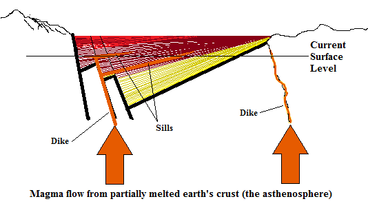
During the Early (Lower) Jurassic Period, molten magma began intruding into fractures and weak points in both the newly deposited Late (Upper) Triassic sediments of the Gettysburg Basin and some adjoining formations of earlier origin. This magma heated and hardened the sediments it contacted and, as it slowly cooled, became diabase. Diabase sills, presently exposed at the surface after millions of years of erosion, are the foundation of the falls, the nearby hills, and several of the islands in the Gettysburg Basin Archipelago. Narrow diabase dikes intruded some of the faults in pre-basin rock to form ridges that often extend well beyond the boundaries of the original rift valley.
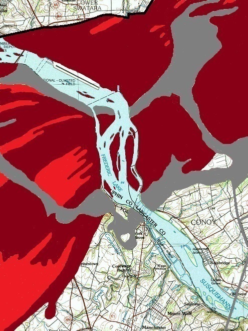
Sills of igneous York Haven Diabase (gray) in the vicinity of Conewago Falls and Three Mile Island. The black line indicates the location of the border fault, a block-fault where bedrock broke away and subsided as a half-graben to create the Gettysburg Basin. The hinge for the sinking crust was in the direction of the lower right of the image, where the diabase dike that forms Haldeman Riffles can be seen as a thin gray line. (Base image from United States Geological Survey Historical Topographic Map Collection-1984)
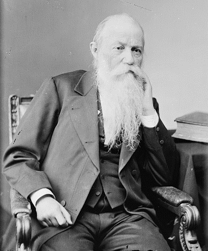
Of the formations of York Haven Diabase, Professor Samuel Steman Haldeman wrote in Rupp’s History of Lancaster County (1844)…
“…the most interesting feature in the Conewago hills, is the large amount of weathered blocks on the surface, of a hard grey stone made up of white and black particles. This is a trap rock of the variety called greenstone, and identical in composition with the smaller ridges which traverse different parts of the country, under the name ironstone, a mineral remarkable for the sonorous ring produced when struck. The finer texture of the latter is produced by the rapid cooling of the material, consequent upon the comparatively small quantity of matter; this rock being of igneous origin, and injected from below in a melted condition. In the Conewago rock the quantity of material is so great, that in the length of time required to solidify, the constituents were able to enter into combinations; or crystallize, in a manner; whence the felspar and hornblend appear in distinct particles.”
Samuel Steman Haldeman was born in 1812 at Locust Grove along the Susquehanna River just downstream of Conewago Falls near Bainbridge, Lancaster County, Pennsylvania. His first professional endeavor was assisting in the early geological surveys of New Jersey and Pennsylvania, including work along the Susquehanna River in Dauphin and Lancaster Counties in 1837. (Library of Congress image)
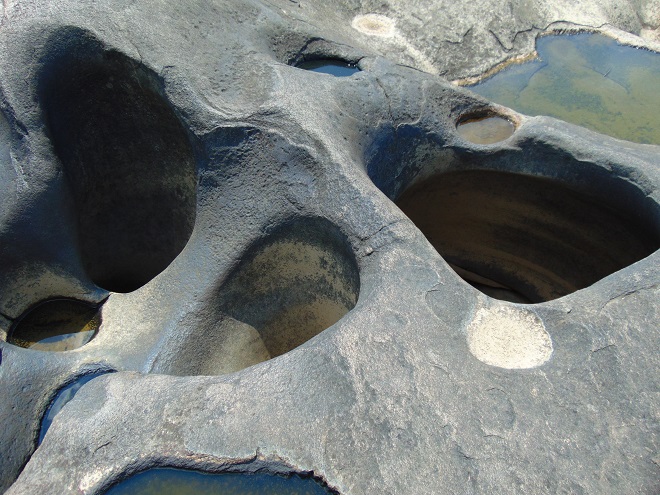
Visible during periods of low water, the Pothole Rocks of Conewago Falls are the result of long-term erosion of York Haven Diabase bedrock by suspended abrasives and the river’s “bed load” (pebbles, gravel, sand, etc.).
From just upstream of the Pennsylvania Turnpike bridge through Conewago Falls, the river wears away at the silty mudstone, conglomerate, sandstone, and shale of the Gettysburg Formation. More than 200 million years ago, these reddish sediments, sometimes called Triassic redbeds, eroded from surrounding highlands into the rift valley of the Gettysburg Basin—covering the previously deposited New Oxford Formation sediments. Over the following 10 million years, York Haven Diabase intruded these sediments and formed the bedrock of Conewago Falls and other unique geologic features.
Gettysburg conglomerate (red) and the silty mudstones of the Gettysburg Formation (maroon), were deposited in the subsiding basin about 220 to 200 million years ago, then intruded by igneous York Haven Diabase prior to 190 million years ago. The Gettysburg Formation is approximately 16,000 feet deep in some areas. York Haven Diabase at Conewago Falls, its type locality, is about 2,500 feet thick. (Base image from United States Geological Survey Historical Topographic Map Collection-1984)The igneous York Haven Diabase of Conewago Falls with hills composed of Gettysburg Formation mudstones and Gettysburg conglomerate in the background to the northwest.
Below the falls and downstream to Bainbridge, the river flows through the lighter-colored and slightly older sedimentary rocks, mostly sandstone, shale, and conglomerate, of the New Oxford Formation.
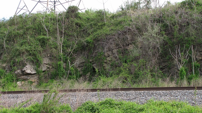
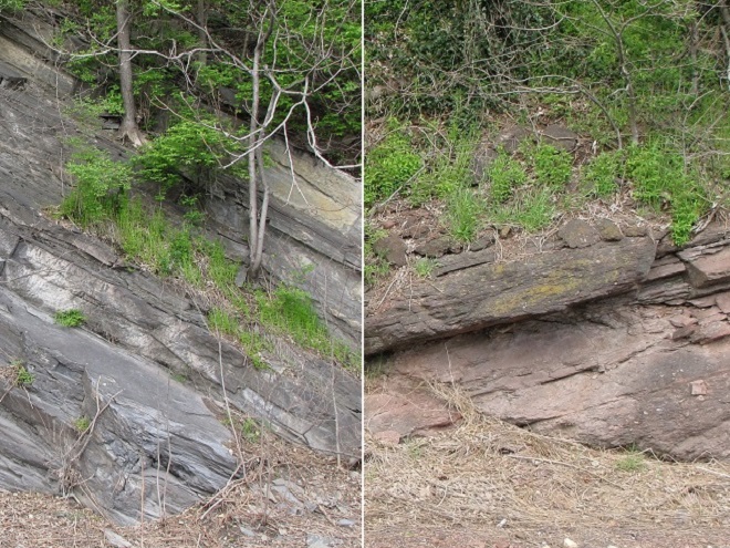
The base layers of the Gettysburg Basin, deposited about 230 to 220 million years ago, are composed predominately of New Oxford conglomerate (bright yellow) and the arkosic sandstones of the New Oxford Formation (dull yellow). The latter is nearly 4,000 feet thick where the Susquehanna passes through. Limestone fanglomerate (orange), up to 200 feet thick, is the base layer in the floor of the basin where it is bisected by the river. (Base image from United States Geological Survey Historical Topographic Map Collection-1984)In Lancaster County along the Northwest River Trail, just northwest of Bainbridge, arkosic sandstones of the New Oxford Formation are visible along the adjacent railroad line. Note the tilt of the strata. After being deposited horizontally in the bottom of the rift valley between 230 and 220 million years ago, the layers of solidified New Oxford sediments were tilted toward the northwest by the continuing subsidence of the Gettysburg Basin half-graben along the border fault. The basin continued to sink for almost 20 million more years while the sediments of the Gettysburg Formation and Gettysburg conglomerate were deposited.A thin layer of New Oxford conglomerate can be seen along the Northwest River Trail underlying this stream passage beneath the railroad almost a mile northwest of Bainbridge. Again, note the tilt of the rock toward the border fault located to the northwest.A close-up view of New Oxford conglomerate showing the small rounded pebbles that indicate a layer of sediments deposited by an ancient stream or along a long-gone inland shoreline.
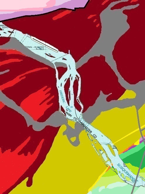
At Bainbridge, the river’s waters exit the present-day remains of the Gettysburg Basin and enter formations of Cambrian limestone and dolomite, and, a little further downstream, pass through metamorphic Cambrian quartzite. The basin’s New Oxford rock formerly overlaid these much older formations, but has since eroded away.
Cambrian and Ordovician bedrock underlies much of the Gettysburg Basin. In the vicinity of the river, Ordovician Epler Formation limestone (light purple) is exposed along the border fault on the northwest side of the basin. Epler limestone is actively quarried there and probably makes up a large portion of the top layer of the half-graben beneath the Gettysburg Basin sediments. Note the small outcrop of Epler limestone along the southeast edge of the basin in the lower right. This surface exposure becomes more extensive just a short distance to the east at Rheems, where again, Epler limestone is quarried. Along the river, all surface rock along the southeast edge of the basin is of older Cambrian origin. (Base image from United States Geological Survey Historical Topographic Map Collection-1984)The border fault along the northwest boundary of the Gettysburg Basin intersects the Susquehanna River just upstream of the Pennsylvania Turnpike bridge. Though the fault is not visible at the surface here, rocky outcrops along PA Route 230 west of the turnpike between Highspire and Steelton reveal its location. Along the embankment on the north side of the road, Epler limestone can be seen to the west of the fault (left) while Triassic redbeds of the Gettysburg Formation are visible to the east (right).Hypothetical view of the Triassic-Jurassic Gettysburg Basin strata under the Susquehanna River. Cambrian and Ordovician formations bordering and underlying the basin are shown where known. Beneath them, Precambrian bedrock is probable.
Originally deposited as sediments precipitated from seawater on a continental shelf, Cambrian formations along the river’s shorelines downstream of the Gettysburg Basin consist of what were formerly the overlying strata of an anticline that, today, reveals itself as an erosion-resistant metamorphic base layer—Lower Cambrian Chickies Formation quartzite. This anticline is best seen further downstream where the Susquehanna passes through Chickies Rock, just north of Columbia. Nearer the basin, and just downstream of Bainbridge, or more specifically below Locust Grove and the mouth of Conoy Creek, one of the eroded upper layers, the Ledger Formation of dolomite, has been extensively quarried. It and remnants of other Cambrian formations that once overlaid the Chickies Formation are conspicuous at outcrops along the river in the vicinity.
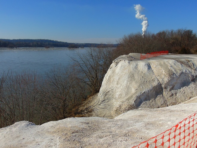
Millbach Formation limestone of Cambrian origin is the contact strata underlying the Triassic Gettysburg Basin along its southeast border at the Susquehanna River. Several hundred yards southeast of its Race Street access in Bainbridge, the Northwest Lancaster County River Trail passes through this wooded outcrop.An outcrop of Vintage Formation argillaceous dolomite is the foundation of the bright white cliffs along the Susquehanna just downstream of Bainbridge near Locust Grove, Lancaster County, PA. At the adjacent Billmeyer Quarry, this dolomite and overlying layers of Ledger Formation dolomite were mined and processed until 1957. “White Cliffs”, also known as the “White Cliffs of Conoy”, is dumped waste material from these operations. This interesting overlook can be accessed from the Northwest Lancaster County River Trail. But beware, the clay content of the Vintage Formation dolomite will cause it to stick to your shoes and clothing. You’ll be dragging home mud that’s more than 500,000,000 years old!
The “hinge” line for the “half-graben” that formed the Gettysburg Basin when Pangaea began stretching apart was located in the vicinity of these Cambrian formations. The “hinge” remained mostly intact as the existing bedrock slowly subsided, eventually dipping more than a mile deep along the block-fault line near the present-day location of the Pennsylvania Turnpike bridge. The sediments that consolidated into the Gettysburg and New Oxford Formations filled this rift valley as it deepened. The layers settled into the trough, accumulations often thinnest near the axis and thicker near the fault, creating tapered strata. If we could project the lines between the strata layers of the remaining Gettysburg and New Oxford Formations, they may point toward a convergence point far above present-day ground level in the general downstream direction of the Cambrian formations, allowing one to ponder the enormous volume of rock that has eroded during the past 190 million years.
Haldeman Riffles is a small tumble of rapids located where a thin ledge of diabase—a dike—intruded faulted Cambrian formations downstream of the Gettysburg Basin. It seems quite probable that this Cambrian rock, weakened by the hinging and the sinking of the rift valley, was intruded by the molten diabase magma from the asthenosphere to form the dike at Haldeman Riffles at about the same time diabase intruded the Gettysburg and New Oxford Formations further upstream.
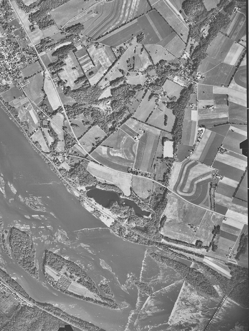
Under pressure, magma from the asthenosphere intruded the slumping lithosphere by entering fractures, including block faults, created by the half-graben. The magma heated and hardened rock with which it made contact while slowly cooling to become diabase. Diabase dikes, such as the one at Haldeman Riffles (right), formed where magma filled cracks that cut across strata and bedding. Diabase sills formed where magma followed the strata in the Gettysburg Formation sediments before solidifying. Formerly concealed well below the surface, the diabase and the thermally metamorphosed rock on its flanks has been exposed by 190 million years of erosion.The location of the diabase dike that forms Haldeman Riffles can be discerned in this aerial photograph as an uncultivated tree-covered ridge that extends from the upper right of the image to the river shoreline at the site of the riffles in the lower center. The large set of rapids downstream of Haldeman Riffles near the railroad bridge (Schock’s) is formed by Chickies Formation quartzite, which underlies the river bottom for the next five miles to Chickies Rock. White cliffs of argillaceous dolomite and the flooded excavations of Billmeyer Quarry can be seen along the shoreline upstream of Haldeman Riffles. (United States Department of Agriculture-Agricultural Stabilization and Conservation Service image)Chickies Formation quartzite cliffs at “Scull’s Rock” on the York County shoreline as seen from the Northwest Lancaster County River Trail’s underpass at the Schock’s Mill railroad bridge just downstream of Haldeman Riffles.
In the area we currently recognize as the Susquehanna River watershed, fossils from the Gettysburg Basin and neighboring Newark Basin are the most recent geologic evidence available to indicate the presence of dinosaurs and other life during the Mesozoic Era (252 to 66 million years ago). Erosive forces have claimed nearly all sediments laid down after the basin’s formation, particularly those of the Jurassic and Cretaceous Periods—the time of the largest of dinosaurs. Here are some of the life forms discovered as fossils or trace fossils in what remains of the Triassic strata of the Susquehanna River valley.
THE FOSSIL RECORD OF THE MESOZOIC ERA
“The Age of Reptiles”
Fossil Evidence of
TRIASSIC LIFE
in the Lower Susquehanna River Watershed
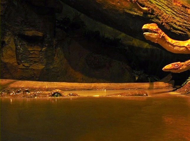
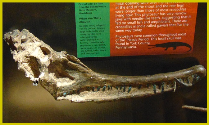
Curious Coelophysis bauri dinosaurs are watched by a motionless Rutiodon carolinensis phytosaur. During the Late (Upper)Triassic Period, the climate in what is today the lower Susquehanna valley was influenced by its lower latitude at the time, resembling conditions presently found in the Caribbean Islands and southern Florida. The scene depicted here is hypothetical; evidence of the phytosaur comes from the New Oxford Formation (230-220 million years ago) while that of the dinosaurs comes from the more recent Gettysburg Formation (220-200 million years ago). (Exhibit: State Museum of Pennsylvania, Harrisburg)
The present-day Lower Susquehanna River Watershed (located in the upper left of the image just to the northwest of the African Plate) lies just north of the equator in this representation of the supercontinent Pangea as it existed 230 million years ago. Sediments that became the New Oxford Formation started to accumulate in the subsiding Gettysburg Basin at this time. Within them, some plants and animals of the period were recorded as fossils. (Base image by Stampfil and Borel from Tethyan Plate Tectonic working group of the Institut de Mineralogie et Petrographie, Universite de Lausanne)
Within the New Oxford Formation, we find fossil evidence of a variety of the tropical plants and animals that inhabited the Gettysburg Basin during the Late Triassic—230 to 220 million years ago.
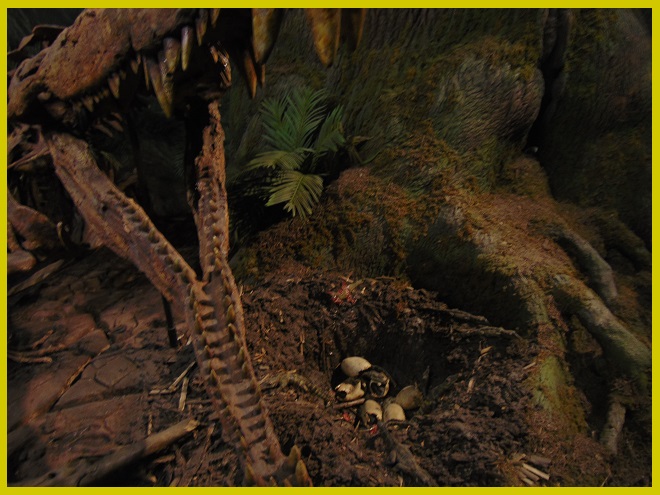
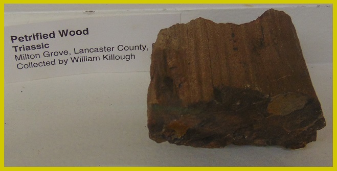
New Oxford Formation- The skull of Anaschisma browni (Koskinonodon/Buettneria perfectus), a large salamander-like amphibian that had needle-like teeth and attained a length of five feet or more. Zion’s View, York County, PA. (Specimen: State Museum of Pennsylvania, Harrisburg)New Oxford Formation- A phytosaur (Rutiodon carolinensis) skull. Note that the nostrils are above the posterior end of the jaws (below green part of sign). Phytosaurs are not considered to be ancestors of modern alligators and crocodiles, but more likely descended on a separate, possibly parallel, lineage that became extinct. Trace fossils (footprints) believed to be those of a Late Triassic crocodile (either Cheirotheroides pilulatus or Batrachopus deweyi) were discovered in the vicinity of this specimen’s origin in 2017. Zion’s View, York County, PA. (Cast of specimen: State Museum of Pennsylvania, Harrisburg. On loan to the North Museum, Lancaster, PA)New Oxford Formation- The crocodile-like Rutiodon carolinensis lurks beneath the surface of the water. Unlike alligators and crocodiles, a phytosaur’s nostrils were just in front of it’s eyes, not toward the anterior end of a long snout. Its rear legs were proportionally longer than those of crocodilians. (Life-sized model: State Museum of Pennsylvania, Harrisburg)New Oxford Formation- A phytosaur tooth. Zion’s View, York County, PA. (Specimen: State Museum of Pennsylvania, Harrisburg)New Oxford Formation- A “giant phytosaur” (Redondosaurus species). Life-sized model of an adult skeleton and nest. This reconstruction is based upon the fossil tooth specimen seen in the previous image. (Exhibit: State Museum of Pennsylvania, Harrisburg)New Oxford Formation- Petrified wood. Milton Grove, Lancaster County, PA. (Specimen: North Museum, Lancaster, PA)
In 1900, the United States Geological Survey published, in its twentieth annual report, an account of the Triassic plant fossils found in New Oxford Formation sediments near Conewago Falls. This account, “Triassic Flora of York County, Pennsylvania”, was a collaboration between Atreus Wanner, a York County educator and amateur paleontologist, and Professor William M. Fontaine. The latter examined fossils Wanner had recovered from cuts along the North Central Railroad line south of York Haven and from excavations along Little Conewago Creek near Manchester. Fontaine discovered among Wanner’s collection many new species of fossil plants, thus rendering Wanner’s samples the type specimens. Two of the new cycads were named for Wanner—Ctenophyllum wannerianum and Cycadeospermum wanneri.
These fourteen plates from Wanner and Fontaine’s work illustrate the fossil remains of some of the tropical plants found in the Gettysburg Basin 230 to 220 million years ago—a time when the area was at a latitude similar to that of the present-day Caribbean Islands and southern Florida.
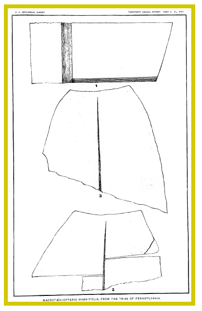
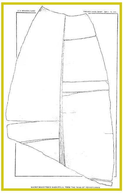
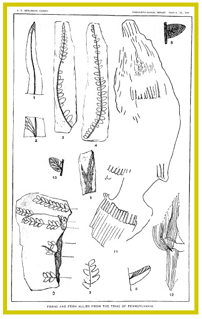
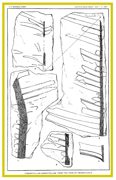
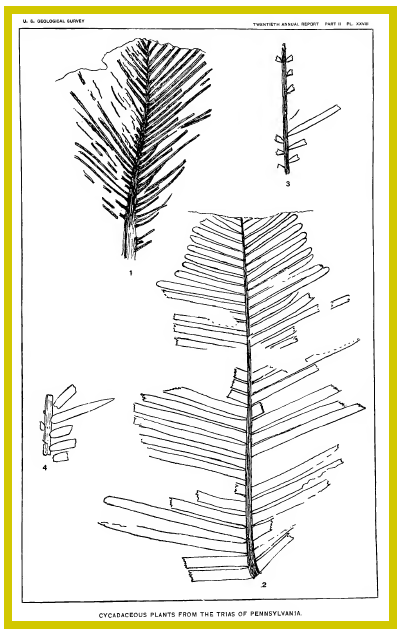
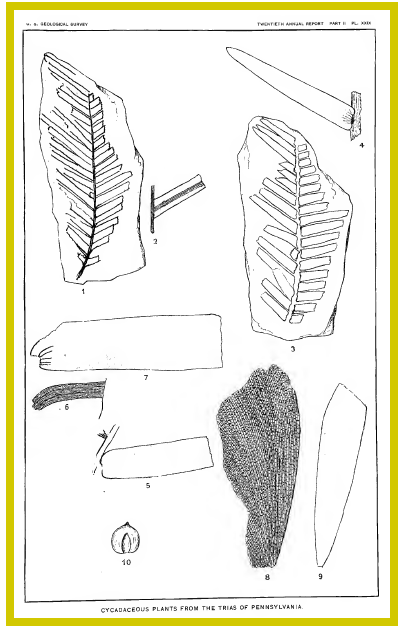
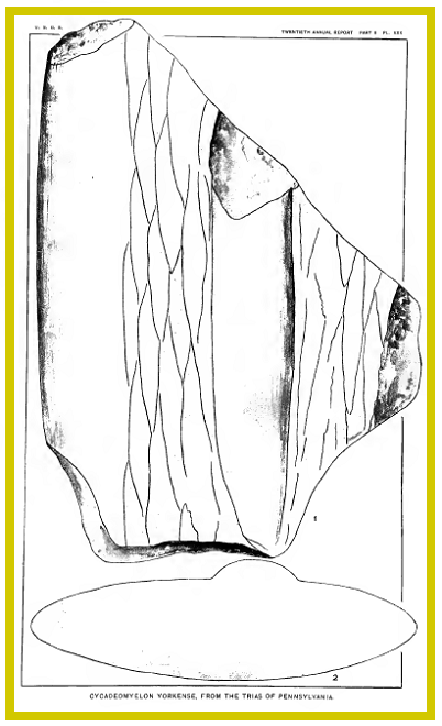
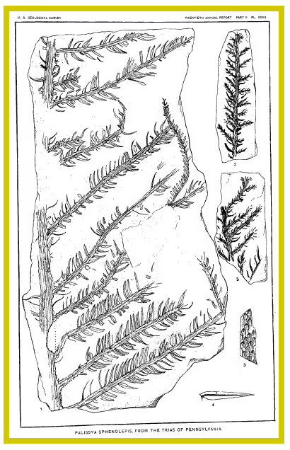
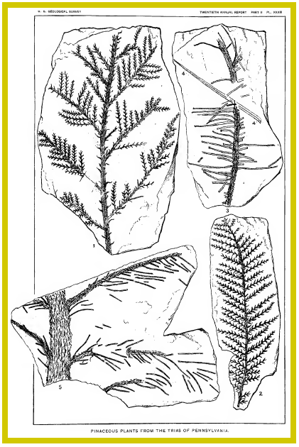
New Oxford Formation- Ferns: Figs. 1-5. Cladophlebis reticulata. (Fossil sketches by Atreus Wanner, edited by Prof. William M. Fontaine, “Triassic Flora of York County Pennsylvania”, Plate XXI, United States Geological Survey, Twentieth Annual Report, 1900)New Oxford Formation- Ferns: Figs. 1 & 2. Thinnfeldia? reticulata, Fig. 3. Asterocarpus falcatus, Figs. 4, 5? & 6?. Taeniopteris? yorkensis. Figs. 7-9. Macrotaeniopteris magnifolia. (Fossil sketches by Atreus Wanner, edited by Prof. William M. Fontaine, “Triassic Flora of York County Pennsylvania”, Plate XXII, United States Geological Survey, Twentieth Annual Report, 1900)New Oxford Formation- Ferns: Figs. 1-3. Enlargements of nerves of Macrotaeniopteris magnifolia. (Fossil sketches by Atreus Wanner, edited by Prof. William M. Fontaine, “Triassic Flora of York County Pennsylvania”, Plate XXIII, United States Geological Survey, Twentieth Annual Report, 1900)New Oxford Formation- Ferns: Macrotaeniopteris magnifolia. (Fossil sketches by Atreus Wanner, edited by Prof. William M. Fontaine, “Triassic Flora of York County Pennsylvania”, Plate XXIV, United States Geological Survey, Twentieth Annual Report, 1900)New Oxford Formation- Ferns and fern allies: Figs. 1 &2. Pseudoddanaeopis plana, Figs. 3-5. Lonchopteris oblonga, Fig. 6. Sagenopteris sp., Figs. 7 & 8. Acrostichites linnaeaefolius, Figs. 9 & 10. Acrostichites microphyllus, Figs. 11 & 12. Equisetum rogersii. (Fossil sketches by Atreus Wanner, edited by Prof. William M. Fontaine, “Triassic Flora of York County Pennsylvania”, Plate XXV, United States Geological Survey, Twentieth Annual Report, 1900)New Oxford Formation- Cycadaceous plants: Fig. 1. Anomozamites princeps, Figs. 2 & 3. Pterophyllum inaequale. (Fossil sketches by Atreus Wanner, edited by Prof. William M. Fontaine, “Triassic Flora of York County Pennsylvania”, Plate XXVI, United States Geological Survey, Twentieth Annual Report, 1900)New Oxford Formation- Cycadaceous plants: Figs. 1-5. Ctenophyllum grandifolium. (Fossil sketches by Atreus Wanner, edited by Prof. William M. Fontaine, “Triassic Flora of York County Pennsylvania”, Plate XXVII, United States Geological Survey, Twentieth Annual Report, 1900)New Oxford Formation- Cycadaceous plants: Fig. 1. Ctenophyllum wannerianum, Fig. 2. Dioonites carnallianus, Figs. 3 & 4. Zamites pennsylvanicus. (Fossil sketches by Atreus Wanner, edited by Prof. William M. Fontaine, “Triassic Flora of York County Pennsylvania”, Plate XXVIII, United States Geological Survey, Twentieth Annual Report, 1900)New Oxford Formation- Cycadaceous plants: Figs. 1-4. Zamites yorkensis, Figs. 5-7. Podozamites distans, Figs. 8 & 9. Sphenozamites rogersianus, Fig. 10. Cycadeospermum wanneri. (Fossil sketches by Atreus Wanner, edited by Prof. William M. Fontaine, “Triassic Flora of York County Pennsylvania”, Plate XXIX, United States Geological Survey, Twentieth Annual Report, 1900)New Oxford Formation- Cycadaceous plants: Fig. 1. Cycademyelon yorkense, Fig. 2. Cross-section of trunk, Cycademyelon yorkense. (Fossil sketches by Atreus Wanner, edited by Prof. William M. Fontaine, “Triassic Flora of York County Pennsylvania”, Plate XXX, United States Geological Survey, Twentieth Annual Report, 1900)New Oxford Formation- Ginkgoaceous and pinaceous plants: Figs. 1 & 2. Baiera muensteriana, Figs. 3-5. Palissya diffusa, Figs. 6-8. Brachyphyllum yorkense, Fig. 9. ? Brachyphyllum yorkense ?. (Fossil sketches by Atreus Wanner, edited by Prof. William M. Fontaine, “Triassic Flora of York County Pennsylvania”, Plate XXXI, United States Geological Survey, Twentieth Annual Report, 1900)New Oxford Formation- Pinaceous plants: Figs. 1-5. Palissya sphenolepis. (Fossil sketches by Atreus Wanner, edited by Prof. William M. Fontaine, “Triassic Flora of York County Pennsylvania”, Plate XXXII, United States Geological Survey, Twentieth Annual Report, 1900)New Oxford Formation- Pinaceous plants: Figs. 1 & 2. Cheirolepis muensteri, Figs. 3-5. Schizolepis liaso-kueperinus. (Fossil sketches by Atreus Wanner, edited by Prof. William M. Fontaine, “Triassic Flora of York County Pennsylvania”, Plate XXXIII, United States Geological Survey, Twentieth Annual Report, 1900)New Oxford Formation- Pinaceous and monocotyledonous plants: Figs. 1 &2. Araucarites? pennsylvaninicus, Fig. 3. Araucarites yorkensis, Figs. 4-6. Yorkia gramineoides. (Fossil sketches by Atreus Wanner, edited by Prof. William M. Fontaine, “Triassic Flora of York County Pennsylvania”, Plate XXXIV, United States Geological Survey, Twentieth Annual Report, 1900)
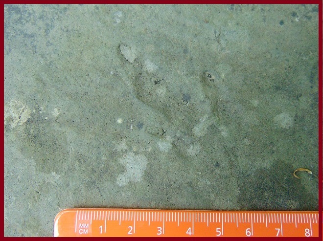
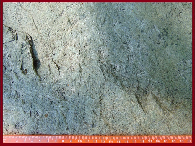
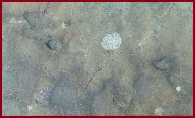
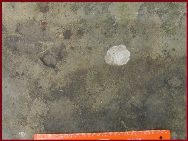
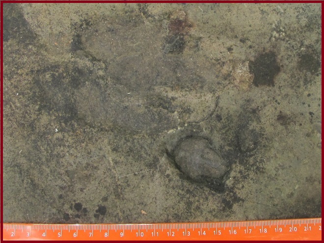
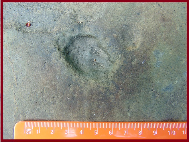
As fossilized footprints in the Gettysburg Formation of the Gettysburg Basin, we find evidence of the emergence of bipedal dinosaurs during the Late Triassic—220 to 200 million years ago.
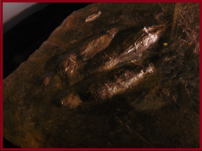
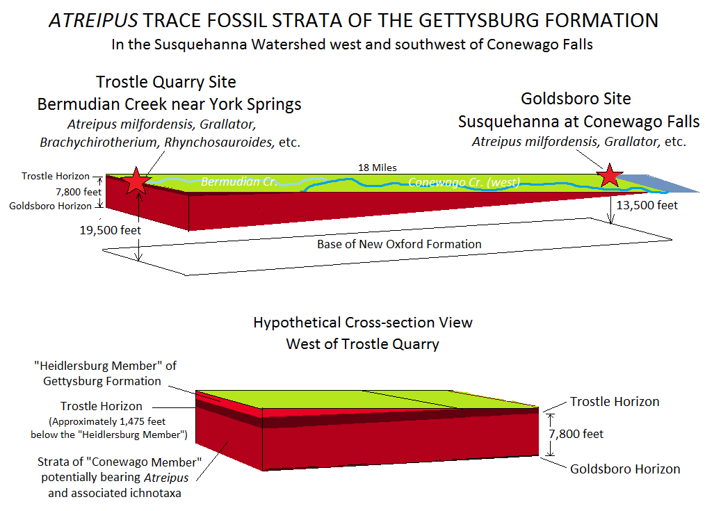
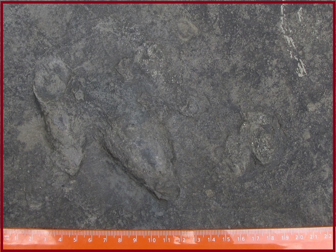
Gettysburg Formation (“Conewago Member”)- The trace fossil Atreipus milfordensis (positive cast of hind-foot track). Due to the uncertainty of the identity of the animal that left the impression, the name, known as the ichnotaxon, describes the track, not the species that made it. Some trace fossils, including those of Atreipus, are evidence that many dinosaurs were transitioning to three-toed bipeds, traveling mostly upright and losing use of the outer two of the five toes on each foot. Trostle Quarry, York Springs, Adams County, PA. (Specimen: State Museum of Pennsylvania, Harrisburg)Prior to 1889, while surveying Gettysburg shale in a borrow pit along the Susquehanna south of Goldsboro, York County, Atreus Wanner uncovered, along with other trace fossils, the footprints eventually known as Atreipus milfordensis. In recognition of his discovery, the genus Atreipus was later named in his honor. Because each layer of sediment continued to subside within the Gettysburg Basin half-graben at a southeast to northwest tilt after being deposited, both the Trostle Quarry and the Goldboro borrow pit horizons can be found near the present-day ground surface, despite the latter being located in strata more than a mile deeper than the former.Gettysburg Formation- The dinosaur Coelophysis bauri. The three-toed tracks of the Atreipus-Grallator “plexus” are believed to have been made by this or similar bipedal dinosaurs of the Late Triassic epoch. Coelophysis genera dinosaurs were members of Theropoda, the suborder of hollow-boned dinosaurs that would in time include great predators like Tyrannosaurus, and dinosaurs that would evolve into birds. (Exhibit: State Museum of Pennsylvania, Harrisburg)Gettysburg Formation (“Conewago Member”)- Atreipus milfordensis trace fossil of hind-foot (left) and front-foot (right) impressions. Trostle Quarry, York Springs, Adams County, PA. (Specimen in cap rock on Plum Run Bridge, Confederate Avenue, Gettysburg National Military Park)Gettysburg Formation (“Conewago Member”)- A trace fossil identified as Anchisauripus (Eubrontes) sillimani (positive cast of hind-foot track). Trostle Quarry, York Springs, Adams County, PA. (Specimen in cap rock on Plum Run Bridge, Confederate Avenue, Gettysburg National Military Park)Gettysburg Formation (“Conewago Member”)- A small footprint trace fossil identified as Grallator tenuis. Trostle Quarry, York Springs, Adams County, PA. (Specimen in cap rock on Plum Run Bridge, Confederate Avenue, Gettysburg National Military Park)Gettysburg Formation (“Conewago Member”)- A trace fossil of vague hind-foot impressions tentatively identified as Otozoum minus (toes pointed toward the bottom of the image along an axis from the upper left to bottom right). Trostle Quarry, York Springs, Adams County, PA. (Specimen in cap rock on Plum Run Bridge, Confederate Avenue, Gettysburg National Military Park)Gettysburg Formation (“Conewago Member”)- Trace fossil of the footprints of one or more unidentified reptiles. Trostle Quarry, York Springs, Adams County, PA. (Specimen in cap rock on Plum Run Bridge, Confederate Avenue, Gettysburg National Military Park)Gettysburg Formation (“Conewago Member”)- Closer view of the previous image showing trace fossil of the footprints of one or more unidentified reptiles. Trostle Quarry, York Springs, Adams County, PA. (Specimen in cap rock on Plum Run Bridge, Confederate Avenue, Gettysburg National Military Park)Gettysburg Formation (“Conewago Member”)- Trace fossil of footprints left by one or more reptiles (close-up of the previous image). The large impression to the upper left appears consistent with the hind foot of Atreipus milfordensis, however the smaller impression(s) to the lower right are not typical of the A. milfordensis forelimbs. Trostle Quarry, York Springs, Adams County, PA. (Specimen in cap rock on Plum Run Bridge, Confederate Avenue, Gettysburg National Military Park)Gettysburg Formation (“Conewago Member”)- Trace fossil of footprints left by one or more unidentified reptiles (close-up of impressions visible in the previous image). Trostle Quarry, York Springs, Adams County, PA. (Specimen in cap rock on Plum Run Bridge, Confederate Avenue, Gettysburg National Military Park)
A single dinosaur skeleton fossil has been found in the Lower Susquehanna River Watershed. It is of Late Triassic origin and was preserved in Hammer Creek Formation shale to the east of the Gettysburg Basin in the neighboring Newark Basin near Bowmansville in northeastern Lancaster County, Pennsylvania.
Hammer Creek Formation in Newark Basin- The fossilized skeleton of the dinosaur Sphodrosaurus pennsylvanicus. It is currently being called a “…fossil reptile of uncertain relationships…” Bowmansville, Lancaster County, PA. (Cast of the holotype specimen in the North Museum, Lancaster, PA, collection: State Museum of Pennsylvania, Harrisburg)
TIME SINCE THE GETTYSBURG BASIN
Fossil Evidence of
JURASSIC LIFE
in the Lower Susquehanna River Watershed
The global increase in volcanic activity that accompanied the separation of supercontinent Pangea is believed to have contributed to the extinction event that defines the boundary between the Triassic and Jurassic Periods (201.3 million years ago). The timing of Early Jurassic igneous diabase intrusions into the sediments of the Gettysburg and Newark Basins coincides with this volcanic activity and may have contributed to its collective effect.
Within the present-day lower Susquehanna valley, diabase sills and dikes that intruded the Triassic formations of the Gettysburg and Newark Basins more than 190 million years ago are the only remaining rock from the Jurassic Period. In several locations, diabase dikes intruded faults in bordering formations of a much earlier origin. Because diabase is in a molten igneous state and is subterranean when deposited, it contains no fossil record of life. Any layers of sediments that may have been deposited during the Jurassic Period, including those which may have preserved the remains of enormous dinosaurs as fossils, have since eroded away. There is evidence of but one gigantic dinosaur from this time—”Dinosaur Rock”.
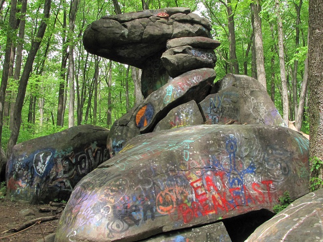
Dinosaur Rock on State Game Lands #145 near Colebrook in Lebanon County, Pennsylvania, is the unique remnant of a subterranean Early Jurassic diabase intrusion, a sill, around which softer Triassic Hammer Creek sediments (sandstone and conglomerate) have eroded away. Spheroidal weathering has left the diabase boulders with rounded edges. Dinosaur Rock is in an area known as “Narrow Neck”, a thin strip of Triassic-Jurassic deposits linking the Gettysburg Basin to the west and the Newark Basin to the east.
The beginning of the rift between North America and Africa that would become the Atlantic Ocean is evident in this illustration of the early stages of the separation of supercontinent Pangea. The Late Triassic rift that includes the Gettysburg and Newark Basins had, by this time, stabilized and was being intruded by igneous Jurassic Diabase. (Plate Tectonics Map by C. R. Scotese, PALEOMAP Project [www.scotese.com])By the Late Jurassic, the early Atlantic Ocean is clearly defined. In the area that is the present-day Lower Susquehanna River Watershed, the tectonic activity that created the Gettysburg and Newark Basins had ended and the area entered the extended period of erosion that continues to this day. (Plate Tectonics Map by C. R. Scotese, PALEOMAP Project [www.scotese.com])
Fossil Evidence of
CRETACEOUS LIFE
in the Lower Susquehanna River Watershed
More to follow on this topic soon.
THE FOSSIL RECORD OF THE CENOZOIC ERA
“The Age of Mammals”
During the Cenozoic Era, a time that began with the mass extinctions that eliminated the colossal dinosaurs (66 million years ago) and extends to the present day, a stream slowly enlarged a path through the faulted rocks of towering mountains to capture the flows of neighboring waterways and become a great river. It found passage to the sea—a “new” and expanding Atlantic Ocean—by eroding a channel through a low saddle in a faulted formation of diabase, washing away Triassic redbeds and other rock while leaving terraces of alluvium surrounding its path. After the impact of a mile-wide meteor that left a crater 56 miles in diameter and a mile deep in the ocean floor near the present-day location of Norfolk, Virginia, it collected new tributaries and carved a steep-sided passage to the edge of the Continental Shelf. It became the Susquehanna, and it created the topographic features we know today as Conewago Falls, the Gettysburg Basin Archipelago (including Three Mile Island), Haldeman Riffles, and the great gorge that meanders from the river’s present-day mouth at Havre de Grace to Norfolk Canyon—its mouth during times of low sea level. During the current interglacial centuries, we call the inland portion of this flooded and silt-filled gorge by a familiar name—Chesapeake Bay. These features are but the current geomorphology of a landscape undergoing a continuous natural process of change.
Approximately 35.5 million years ago, a mile-wide meteor traveling 50,000 miles per hour slammed into the continental shelf at Cape Charles, the present-day location of the mouth of Chesapeake Bay. The area we presently call the lower Susquehanna valley, much of it inundated by the high sea levels of the time, was subjected to a supersonic shock wave, a storm of debris and seawater vapor, and a tidal wave. The event probably eradicated all flora and fauna then living in the region. The fractured bedrock that resulted from its impact helped steer the erosive path of the Susquehanna and its tributaries as they scoured a gorge extending all the way east to Norfolk Canyon, the river’s mouth on the edge of the continental shelf during lowest sea levels. (United States Geological Survey image)
Fossil Evidence of
TERTIARY LIFE
in the Lower Susquehanna River Watershed
More to follow on this topic soon.
Fossil Evidence of
QUATERNARY LIFE
in the Lower Susquehanna River Watershed
More to follow on this topic soon.
The plants, animals, and other life forms found in the basin today have slowly evolved and adapted to ecosystems millions of years in the making. They are the lone legacy of the earlier flora and fauna for which we have no geological record. They are the migrants and movers, species that successfully colonized and recolonized the Lower Susquehanna River Watershed as ecosystems transitioned due to climate cycles and sometimes violent geological events. They have time invested here, and their ancestry predates the basin itself. They are the survivors. Their lineage has overcome everything a changing planet could send their way—then came the humans.
September 10, 2011. Eroded sediments flow through the Gettysburg Basin Archipelago en route to the Chesapeake Bay following the torrential rains and flooding of Tropical Storm Lee. And the beat goes on. (NASA Earth Observatory Image)
TIME BEFORE THE GETTYSBURG BASIN AND THE EMERGENCE OF DINOSAURS
“Pre-Mesozoic/Pre-Triassic Life in the Lower Susquehanna River Watershed”
THE FOSSIL RECORD OF THE PROTEROZOIC EON
Fossil Evidence of
“PRECAMBRIAN ERA” LIFE
in the Lower Susquehanna River Watershed
More to follow on this topic soon.
THE FOSSIL RECORD OF THE PALEOZOIC ERA
Fossil Evidence of
“LOWER PALEOZOIC” LIFE
in the Lower Susquehanna River Watershed
“The Age of Invertebrates”
More to follow on this topic soon.
Fossil Evidence of
CAMBRIAN LIFE
in the Lower Susquehanna River Watershed
“The Age of Invertebrates”
More to follow on this topic soon.
Fossil Evidence of
CAMBRIAN-ORDOVICIAN LIFE
in the Lower Susquehanna River Watershed
“The Age of Invertebrates”
More to follow on this topic soon.
Fossil Evidence of
ORDOVICIAN LIFE
in the Lower Susquehanna River Watershed
“The Age of Invertebrates”
More to follow on this topic soon.
Fossil Evidence of
SILURIAN LIFE
in the Lower Susquehanna River Watershed
More to follow on this topic soon.
Fossil Evidence of
DEVONIAN LIFE
in the Lower Susquehanna River Watershed
“The Age of Fishes”
More to follow on this topic soon.
Fossil Evidence of
MISSISSIPPIAN LIFE
in the Lower Susquehanna River Watershed
More to follow on this topic soon.
Fossil Evidence of
PENNSYLVANIAN LIFE
in the Lower Susquehanna River Watershed
More to follow on this topic soon.
Fossil Evidence of
PERMIAN LIFE
in the Lower Susquehanna River Watershed
“The Age of Amphibians”
More to follow on this topic soon.
SOURCES
Cuffey, Roger J. 2008. “Stop 8—Dinosaur Footprints on the Plum Run Bridge”. Geology of the Gettysburg Mesozoic Basin and Military Geology of the Gettysburg Campaign: Annual Field Conference of Pennsylvania Geologists, 73rd, Gettysburg, Pennsylvania, Guidebook. pp. 130-132.
Donehoo, Dr. George P. 1928. A History of the Indian Villages and Place Names in Pennsylvania. Wennawoods Publishing (1998 reprint). Lewisburg, PA.
Glaeser, J. Douglas. 1966. Provenance, Dispersal, and Depositional Environments of Triassic Sediments in the Newark-GettysburgBasin. Pennsylvania Geological Survey. Fourth Series. General Geology Report 43.
Haldeman, Samuel Steman. 1844. “Geology of Lancaster County”. I. Daniel Rupp’s History of Lancaster County. Gilbert Hills. Lancaster, PA. p.466.
Johnston, Herbert E. 1966. Hydrology of the New Oxford Formation in Lancaster County, Pennsylvania. Pennsylvania Geological Survey. Fourth Series. Bulletin W 23.
Jones, Jeri L., Cuffey, Roger J., and Gordon, Kathy. 2017. “A Probable Protosuchian (Crocodilian) Footprint from the Late Triassic in South-Central Pennsylvania”. Pennsylvania Geology. 47(1):3-7.
Olsen, Paul E., and Baird, Donald. 1986. “The Ichnogenus Atreipus and Its Significance for Triassic Biostratigraphy”: In K. Padian (ed.), The Beginning of the Age of the Dinosaurs, Faunal Change Across the Triassic-Jurassic Boundary. Cambridge University Press. New York, NY. pp. 61-87.
Pennsylvania Geologic Data Exploration (PaGEODE) mapping website. Pennsylvania Geological Survey. www.gis.dcnr.state.pa.us/geology/index.html as accessed June 29, 2019.
Poag, C. W. 1998. The Chesapeake Bay Bolide Impact—A New View of Coastal Plain Evolution. U. S. Geological Survey Fact Sheet 049-98, 2 pp.
Root, Samuel I. 1977. Geology and Mineral Resources of the Harrisburg West Area, Cumberland and York Counties, Pennsylvania. Pennsylvania Geological Survey. Fourth Series. Atlas 148ab.
Stose, George W. and Jonas, Anna I. 1939. Geology and Mineral Resources of York County, Pennsylvania. Pennsylvania Geological Survey. Fourth Series. Bulletin C 67.
Van Diver, Bradford B. 1990. Roadside Geology of Pennsylvania. Mountain Press Publishing Company. Missoula, MT.
Wanner, Atreus. and Fontaine, William M. 1900. “Triassic Flora of York County, Pennsylvania”. In Lester F. Ward (ed.), Status of the Mesozoic Floras of the United States. Extract from the Twentieth Annual Report. United States Geological Survey. Washington, D.C. pp.231-255. (Including Plates XXI-XXXIV, pp.431-458).