
Photo of the Day

LIFE IN THE LOWER SUSQUEHANNA RIVER WATERSHED
A Natural History of Conewago Falls—The Waters of Three Mile Island
As we begin the second half of October, frosty nights have put an end to choruses of annual cicadas in the lower Susquehanna valley. Though they are gone for yet another year, they are not forgotten. Here’s an update on one of our special finds in 2025.
During late June of 1863, the beginning of the third summer of the American Civil War, there was great consternation among the populous of the lower Susquehanna region. Hoping to bring about Union capitulation and an end to the conflict, General Robert E. Lee and his 70,000-man Army of Northern Virginia were marching north into the passes and valleys on the west side of the river. The uncontested Confederate advances posed an immediate threat to Pennsylvania’s capital in Harrisburg and cities to the east. Marching north in pursuit of Lee was the First Corps of the Army of the Potomac, the lead element of the 100,000-man Union force under the direction of newly appointed commander General George G. Meade.
Upon belatedly learning of Meade’s pursuit, Lee hastily ordered the widely separated corps of his army to concentrate on the crossroads town of Gettysburg. As the southern army’s Third Corps under General A. P. Hill approached Gettysburg from the west, they were met by Union cavalry under the leadership of General John Buford. Dismounted and formed up south to north across the Chambersburg Pike, Buford’s men held off Confederate infantry until relieved by the arrival of the Union First Corps. As he deployed his men, the First Corps’ commander, General John F. Reynolds of Lancaster, was struck by a bullet and killed.


If you visit the Gettysburg battlefield, you can find the General John C. Robinson monument at the site of his division’s first-day position along Doubleday Avenue at Robinson Avenue near the Eternal Light Peace Memorial. But that’s not the Robinson we went to Gettysburg to see.
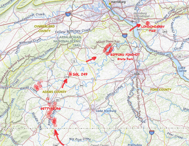
Following up on our sight and mostly sound experiences with some Robinson’s Cicadas, an annual species of singing insect we found thriving at Gifford Pinchot State Park in York County, Pennsylvania, during late July, we spent some time searching out other locations where this native invader from the southern United States could be occurring in the Lower Susquehanna River Watershed.
During mid-August, we stumbled upon a population of Robinson’s Cicadas east of the Susquehanna in the Conewago Creek (east) watershed in Londonderry Township, Dauphin County, and made some sound recordings.
After pondering this latest discovery, we decided to investigate places with habitat characteristics similar to those at both the new Londonderry Township and the earlier Gifford Pinchot State Park locations—successional growth with extensive stands of Eastern Red Cedar on the Piedmont’s Triassic Gettysburg Formation “redbeds”. We headed south towards known populations of Robinson’s Cicadas in Virginia and Maryland to look for suitable sites within Pennsylvania that might bridge the range gap.
Our search was a rapid success. On State Game Lands 249 in the Conewago Creek (west) watershed in Adams County, we found Robinson’s Cicadas to be widespread.


Following our hunch that these lower Susquehanna Robinson’s Cicadas extended their range north through the cedar thickets of the Gettysburg Basin as opposed to hopping the Appalachians from a population reported to inhabit southwest Pennsylvania, we made our way to the battlefield and surrounding lands. We found Robinson’s Cicadas to be quite common and widespread in these areas, even occurring in the town of Gettysburg itself.


The deluge of rain that soaked the lower Susquehanna watershed during last week is now just a memory. Streams to the west of the river, where the flooding courtesy of the remnants of Hurricane Debby was most severe, have reached their crest and receded. Sliding away toward the Chesapeake and Atlantic is all that runoff, laden with a brew of pollutants including but not limited to: agricultural nutrients, sediment, petroleum products, sewage, lawn chemicals, tires, dog poop, and all that litter—paper, plastics, glass, Styrofoam, and more. For aquatic organisms including our freshwater fish, these floods, particularly when they occur in summer, can compound the effects of the numerous stressors that already limit their ability to live, thrive, and reproduce.

One of those preexisting stressors, high water temperature, can be either intensified or relieved by summertime precipitation. Runoff from forested or other densely vegetated ground normally has little impact on stream temperature. But segments of waterways receiving significant volumes of runoff from areas of sun-exposed impervious ground will usually see increases during at least the early stages of a rain event. Fortunately, projects implemented to address the negative impacts of stormwater flow and stream impairment can often have the additional benefit of helping to attenuate sudden rises in stream temperature.

Of the fishes inhabiting the Lower Susquehanna River Watershed’s temperate streams, the least tolerant of summer warming are the trouts and sculpins—species often described as “coldwater fishes”. Coldwater fishes require water temperatures below 70° Fahrenheit to thrive and reproduce. The optimal temperature range is 50° to 65° F. In the lower Susquehanna valley, few streams are able to sustain trouts and sculpins through the summer months—largely due to the effects of warm stormwater runoff and other forms of impairment.


Coldwater fishes are generally found in small spring-fed creeks and headwaters runs. Where stream gradient, substrate, dissolved oxygen, and other parameters are favorable, some species may be tolerant of water warmer than the optimal values. In other words, these temperature classifications are not set in stone and nobody ever explained ichthyology to a fish, so there are exceptions. The Brown Trout for example is sometimes listed as a “coldwater transition fish”, able to survive and reproduce in waters where stream quality is exceptionally good but the temperature may periodically reach the mid-seventies.


More tolerant of summer heat than the trouts, sculpins, and daces are the “coolwater fishes”—species able to feed, grow, and reproduce in streams with a temperature of less than 80° F, but higher than 60° F. Coolwater fishes thrive in creeks and rivers that hover in the 65° to 70° F range during summer.


What are the causes of modern-day reductions in coldwater and coolwater fish habitats in the lower Susquehanna River and its hundreds of miles of tributaries? To answer that, let’s take a look at the atmospheric, cosmic, and hydrologic processes that impact water temperature. Technically, these processes could be measured as heat flux—the rate of heat energy transfer per unit area per unit time, frequently expressed as watts per meter squared (W/m²). Without getting too technical, we’ll just take a look at the practical impact these processes have on stream temperatures.
HEAT FLUX PROCESSES IN A SEGMENT OF STREAM


 Radiation")


Now that we have a basic understanding of the heat flux processes responsible for determining the water temperatures of our creeks and rivers, let’s venture a look at a few graphics from gauge stations on some of the lower Susquehanna’s tributaries equipped with appropriate United States Geological Survey monitoring devices. While the data from each of these stations is clearly noted to be provisional, it can still be used to generate comparative graphics showing basic trends in easy-to-monitor parameters like temperature and stream flow.
Each image is self-labeled and plots stream temperature in degrees Fahrenheit (bold blue) and stream discharge in cubic feet per second (thin blue).

The daily oscillations in temperature reflect the influence of several heat flux processes. During the day, solar (shortwave) radiation and convection from summer air, especially those hot south winds, are largely responsible for the daily rises of about 5° F. Longwave radiation has a round-the-clock influence—adding heat to the stream during the day and mostly shedding it at night. Atmospheric exchange including evaporative cooling may help moderate the rise in stream temperatures during the day, and certainly plays a role in bringing them back down after sunset. Along its course this summer, the West Conewago Creek absorbed enough heat to render it a warmwater fishery in the area of the gauging station. The West Conewago is a shallow, low gradient stream over almost its entire course. Its waters move very slowly, thus extending their exposure time to radiated heat flux and reducing the benefit of cooling by atmospheric exchange. Fortunately for bass, catfish, and sunfish, these temperatures are in the ideal range for warmwater fishes to feed, grow, and reproduce—generally over 80° F, and ideally in the 70° to 85° F range. Coolwater fishes though, would not find this stream segment favorable. It was consistently above the 80° F maximum and the 60° to 70° F range preferred by these species. And coldwater fishes, well, they wouldn’t be caught dead in this stream segment. Wait, scratch that—the only way they would be caught in this segment is dead. No trouts or sculpins here.

Look closely and you’ll notice that although the temperature pattern on this chart closely resembles that of the West Conewago’s, the readings average about 5 degrees cooler. This may seem surprising when one realizes that the Codorus follows a channelized path through the heart of York City and its urbanized suburbs—a heat island of significance to a stream this size. Before that it passes through numerous impoundments where its waters are exposed to the full energy of the sun. The tempering factor for the Codorus is its baseflow. Despite draining a smaller watershed than its neighbor to the north, the Codorus’s baseflow (low flow between periods of rain) was 96 cubic feet per second on August 5th, nearly twice that of the West Conewago (51.1 cubic feet per second on August 5th). Thus, the incoming heat energy was distributed over a greater mass in the Codorus and had a reduced impact on its temperature. Though the Codorus is certainly a warmwater fishery in its lower reaches, coolwater and transitional fishes could probably inhabit its tributaries in segments located closer to groundwater sources without stress. Several streams in its upper reaches are in fact classified as trout-stocked fisheries.


The Kreutz Creek gauge shows temperature patterns similar to those in the West Conewago and Codorus data sets, but notice the lower overall temperature trend and the flow. Kreutz Creek is a much smaller stream than the other two, with a flow averaging less than one tenth that of the West Conewago and about one twentieth of that in the Codorus. And most of the watershed is cropland or urban/suburban space. Yet, the stream remains below 80° F through most of the summer. The saving graces in Kreutz Creek are reduced exposure time and gradient. The waters of Kreutz Creek tumble their way through a small watershed to enter the Susquehanna within twenty-four hours, barely time to go through a single daily heating and cooling cycle. As a result, their is no chance for water to accumulate radiant and convective heat over multiple summer days. The daily oscillations in temperature are less amplified than we find in the previous streams—a swing of about three degrees compared to five. This indicates a better balance between heat flux processes that raise temperature and those that reduce it. Atmospheric exchange in the stream’s riffles, forest cover, and good hyporheic exchange along its course could all be tempering factors in Kreutz Creek. From a temperature perspective, Kreutz Creek provides suitable waters for coolwater fishes.

Muddy Creek is a trout-stocked fishery, but it cannot sustain coldwater species through the summer heat. Though temperatures in Muddy Creek may be suitable for coolwater fishes, silt, nutrients, low dissolved oxygen, and other factors could easily render it strictly a warmwater fishery, inhabited by species tolerant of significant stream impairment.

A significant number of stream segments in the Chiques watershed have been rehabilitated to eliminate intrusion by grazing livestock, cropland runoff, and other sources of impairment. Through partnerships between a local group of watershed volunteers and landowners, one tributary, Donegal Creek, has seen riparian buffers, exclusion fencing, and other water quality and habitat improvements installed along nearly ever inch of its run from Donegal Springs through high-intensity farmland to its mouth on the main stem of the Chiques just above its confluence with the Susquehanna. The improved water quality parameters in the Donegal support native coldwater sculpins and an introduced population of reproducing Brown Trout. While coldwater habitat is limited to the Donegal, the main stem of the Chiques and its largest tributary, the Little Chiques Creek, both provide suitable temperatures for coolwater fishes.


Despite its meander through and receipt of water from high-intensity farmland, the temperature of the lower Conewago (East) maxes out at about 85° F, making it ideal for warmwater fishes and even those species that are often considered coolwater transition fishes like introduced Smallmouth Bass, Rock Bass, Walleye, and native Margined Madtom. This survivable temperature is a testament to the naturally occurring and planted forest buffers along much of the stream’s course, particularly on its main stem. But the Conewago suffers serious baseflow problems compared to other streams we’ve looked at so far. Just prior to the early August storms, flow was well below 10 cubic feet per second for a drainage area of more than fifty square miles. While some of this reduced flow is the result of evaporation, much of it is anthropogenic in origin as the rate of groundwater removal continues to increase and a recent surge in stream withdraws for irrigation reaches its peak during the hottest days of summer.


A little side note—the flow rate on the Conewago at the Falmouth gauge climbed to about 160 cubic feet per second as a result of the remnants of Hurricane Debby while the gauge on the West Conewago at Manchester skyrocketed to about 20,000 cubic feet per second. Although the West Conewago’s watershed (drainage area) is larger than that of the Conewago on the east shore, it’s larger only by a multiple of two or three, not 125. That’s a dramatic difference in rainfall!

The temperatures at the Bellaire monitoring station, which is located upstream of the Conewago’s halfway point between its headwaters in Mount Gretna and its mouth, are quite comparable to those at the Falmouth gauge. Although a comparison between these two sets of data indicate a low net increase in heat absorption along the stream’s course between the two points, it also suggests sources of significant warming upstream in the areas between the Bellaire gauge and the headwaters.

The waters of the Little Conewago are protected within planted riparian buffers and mature woodland along much of their course to the confluence with the Conewago’s main stem just upstream of Bellaire. This tributary certainly isn’t responsible for raising the temperature of the creek, but is instead probably helping to cool it with what little flow it has.

Though mostly passing through natural and planted forest buffers above its confluence with the Little Conewago, the main stem’s critically low baseflow makes it particularly susceptible to heat flux processes that raise stream temperatures in segments within the two or three large agricultural properties where owners have opted not to participate in partnerships to rehabilitate the waterway. The headwaters area, while largely within Pennsylvania State Game Lands, is interspersed with growing residential communities where potable water is sourced from hundreds of private and community wells—every one of them removing groundwater and contributing to the diminishing baseflow of the creek. Some of that water is discharged into the stream after treatment at the two municipal sewer plants in the upper Conewago. This effluent can become quite warm during processing and may have significant thermal impact when the stream is at a reduced rate of flow. A sizeable headwaters lake is seasonally flooded for recreation in Mount Gretna. Such lakes can function as effective mid-day collectors of solar (shortwave) radiation that both warms the water and expedites atmospheric exchange.
 Watershed")
Though Conewago Creek (East) is classified as a trout-stocked fishery in its upper reaches in Lebanon County, its low baseflow and susceptibility to warming render it inhospitable to these coldwater fishes by late-spring/early summer.


The removal of two water supply dams on the headwaters of Hammer Creek at Rexmont eliminated a large source of temperature fluctuation on the waterway, but did little to address the stream’s exposure to radiant and convective heat flux processes as it meanders largely unprotected out of the forest cover of Pennsylvania State Game Lands and through high-intensity farmlands in the Lebanon Valley. Moderating the temperature to a large degree is the influx of karst water from Buffalo Springs, located about two miles upstream from this gauging station, and other limestone springs that feed tributaries which enter the Hammer from the east and north. Despite the cold water, the impact of the stream’s nearly total exposure to radiative and other warming heat flux processes can readily be seen in the graphic. Though still a coldwater fishery by temperature standards, it is rather obvious that rapid heating and other forms of impairment await these waters as they continue flowing through segments with few best management practices in place for mitigating pollutants. By the time Hammer Creek passes back through the Furnace Hills and Pennsylvania State Game Lands, it is leaning toward classification as a coolwater fishery with significant accumulations of sediment and nutrients. But this creek has a lot going for it—mainly, sources of cold water. A core group of enthusiastic landowners could begin implementing the best management practices and undertaking the necessary water quality improvement projects that could turn this stream around and make it a coldwater treasure. An organized effort is currently underway to do just that. Visit Trout Unlimited’s Don Fritchey Chapter and Donegal Chapter to learn more. Better yet, join them as a volunteer or cooperating landowner!


For coldwater fishes, the thousands of years since the most recent glacial maximum have seen their range slowly contract from nearly the entirety of the once much larger Susquehanna watershed to the headwaters of only our most pristine streams. Through no fault of their own, they had the misfortune of bad timing—humans arrived and found coldwater streams and the groundwater that feeds them to their liking. Some of the later arrivals even built their houses right on top of the best-flowing springs. Today, populations of these fishes in the region we presently call the Lower Susquehanna River Watershed are seriously disconnected and the prospect for survival of these species here is not good. Stream rehabilitation, groundwater management, and better civil planning and land/water stewardship are the only way coldwater fishes, and very possibly coolwater fishes as well, will survive. For some streams like Hammer Creek, it’s not too late to make spectacular things happen. It mostly requires a cadre of citizens, local government, project specialists, and especially stakeholders to step up and be willing to remain focused upon project goals so that the many years of work required to turn a failing stream around can lead to success.


You’re probably glad this look at heat flux processes in streams has at last come to an end. That’s good, because we’ve got a lot of work to do.


County Conservation District Tree Sales are underway throughout the Lower Susquehanna River Watershed. Now is the time to order for pickup in April. The prices are a bargain and the selection is fabulous. For species descriptions and more details, visit each tree sale web page (click the sale name highlighted in blue). And don’t forget to order bundles of evergreens for planting in mixed clumps and groves to provide winter shelter and summertime nesting sites for our local birds. They’re only $12.00 for a bundle of 10—can’t beat that deal!
Cumberland County Conservation District Annual Tree Seedling Sale—
Orders due by: Friday, March 24, 2023
Pickup on: Thursday, April 20, 2023 or Friday, April 21, 2023


Dauphin County Conservation District Seedling Sale—
Orders due by: Monday, March 20, 2023
Pickup on: Thursday, April 20, 2023 or Friday, April 21, 2023

Lancaster County Annual Tree Seedling Sale—
Orders due by: Friday, March 10, 2023
Pickup on: Thursday, April 13, 2023

Lebanon County Conservation District Tree and Plant Sale—
Orders due by: Wednesday, March 8, 2023
Pickup on: Friday, April 7, 2023

Perry County Conservation District Tree Sale—(click on 2023 Tree Sale Brochure tab when it scrolls across the page)
Orders due by: March 22, 2023
Pickup on: Thursday, April 13, 2023


To learn more about this project and others, you’ll want to check out the LandStudies website.
The Pennsylvania Department of Environmental Protection has issued a “drought watch” for much of the state’s Susquehanna basin including Dauphin, Lebanon, and Perry Counties—plus those counties to their north. Residents are asked to conserve water in the affected areas.

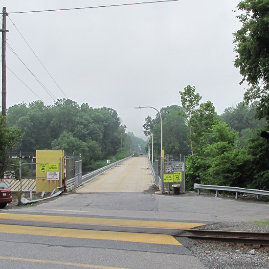
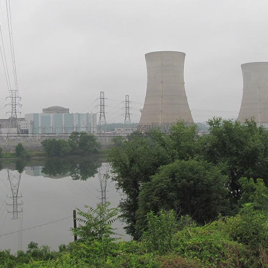
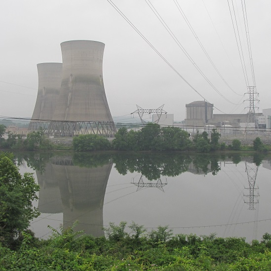
Fifty years ago this week, the remnants of Hurricane Agnes drifted north through the Susquehanna River basin as a tropical storm and saturated the entire watershed with wave after wave of torrential rains. The storm caused catastrophic flooding along the river’s main stem and along many major tributaries. The nuclear power station at Three Mile Island, then under construction, received its first major flood. Here are some photos taken during the climax of that flood on June 24, 1972. The river stage as measured just upstream of Three Mile Island at the Harrisburg gauge crested at 33.27 feet, more than 10 feet above flood stage and almost 30 feet higher than the stage at present. At Three Mile Island and Conewago Falls, the river was receiving additional flow from the raging Swatara Creek, which drains much of the anthracite coal region of eastern Schuylkill County—where rainfall from Agnes may have been the heaviest.


Pictures capture just a portion of the experience of witnessing a massive flood. Sometimes the sounds and smells of the muddy torrents tell us more than photographs can show.
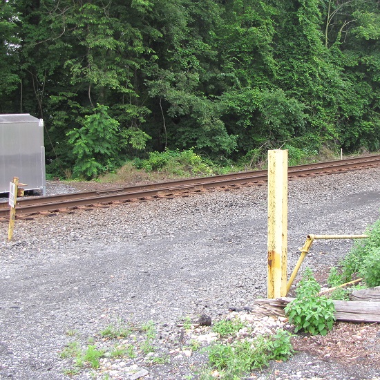
Aside from the booming noise of the fuel tank banging along the rails of the south bridge, there was the persistent roar of floodwaters, at the rate of hundreds of thousands of cubic feet per second, tumbling through Conewago Falls on the downstream side of the island. The sound of the rapids during a flood can at times carry for more than two miles. It’s a sound that has accompanied the thousands of floods that have shaped the falls and its unique diabase “pothole rocks” using abrasives that are suspended in silty waters after being eroded from rock formations in the hundreds of square miles of drainage basin upstream. This natural process, the weathering of rock and the deposition of the material closer to the coast, has been the prevailing geologic cycle in what we now call the Lower Susquehanna River Watershed since the end of the Triassic Period, more than two hundred million years ago.
More than the sights and sounds, it was the smell of the Agnes flood that warned witnesses of the dangers of the non-natural, man-made contamination—the pollution—in the waters then flowing down the Susquehanna.
Because they float, gasoline and other fuels leaked from flooded vehicles, storage tanks, and containers were most apparent. The odor of their vapors was widespread along not only along the main stem of the river, but along most of the tributaries that at any point along their course passed through human habitations.
Blended with the strong smell of petroleum was the stink of untreated excrement. Flooded treatment plants, collection systems overwhelmed by stormwater, and inundated septic systems all discharged raw sewage into the river and many of its tributaries. This untreated wastewater, combined with ammoniated manure and other farm runoff, gave a damaging nutrient shock to the river and Chesapeake Bay.
Adding to the repugnant aroma of the flood was a mix of chemicals, some percolated from storage sites along watercourses, and yet others leaking from steel drums seen floating in the river. During the decades following World War II, stacks and stacks of drums, some empty, some containing material that is very dangerous, were routinely stored in floodplains at businesses and industrial sites throughout the Susquehanna basin. Many were lifted up and washed away during the record-breaking Agnes flood. Still others were “allowed” to be carried away by the malicious pigs who see a flooding stream as an opportunity to “get rid of stuff”. Few of these drums were ever recovered, and hundreds were stranded along the shoreline and in the woods and wetlands of the floodplain below Conewago Falls. There, they rusted away during the next three decades, some leaking their contents into the surrounding soils and waters. Today, there is little visible trace of any.
During the summer of ’72, the waters surrounding Three Mile Island were probably viler and more polluted than at any other time during the existence of the nuclear generating station there. And little, if any of that pollution originated at the facility itself.
The Susquehanna’s floodplain and water quality issues that had been stashed in the corner, hidden out back, and swept under the rug for years were flushed out by Agnes, and she left them stuck in the stinking mud.
It’s that time of year when one may expect to find migratory Neotropical songbirds feeding among the foliage of trees and shrubs in the forests, woodlots, and thickets of the lower Susquehanna valley.
During a late afternoon stroll through a headwaters forest east of Conewago Falls outside Mount Gretna, I was pleased to finally come upon a noisy gathering of about two dozen birds. It had, previous to that, been a quiet two hours of walking, only the rumble of an approaching thunderstorm punctuated the silence. Among this little flock were some chickadees, robins, Gray Catbirds, an Eastern Towhee (Pipilo erythrophthalmus), and a Hairy Woodpecker (Dryobates villosus). Besides the catbirds, there were two other species of Neotropical migrants; both were warblers. No less than six Black-throated Blue Warblers (Setophaga caerulescens) were vying for positions in the trees from which they could investigate the stranger on the footpath below. And among the understory shrubs there were at least as many Ovenbirds (Seiurus aurocapilla) satisfying a similar curiosity.
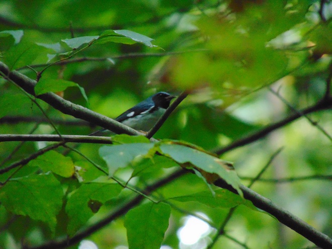
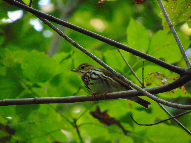
When they depart the Susquehanna valley, these two warbler species will be southbound for wintering ranges that include Florida, many of the Caribbean Islands, Central America, and, for the Ovenbirds, northern South America. Their flights occur at night. During the breeding season and while migrating, both feed primarily on insects and other arthropods . On the wintering grounds, they will consume some fruit. It is during their time in the tropics that the Black-throated Blue Warbler sometimes visits feeding stations that offer grape jelly, much to the delight of bird enthusiasts.
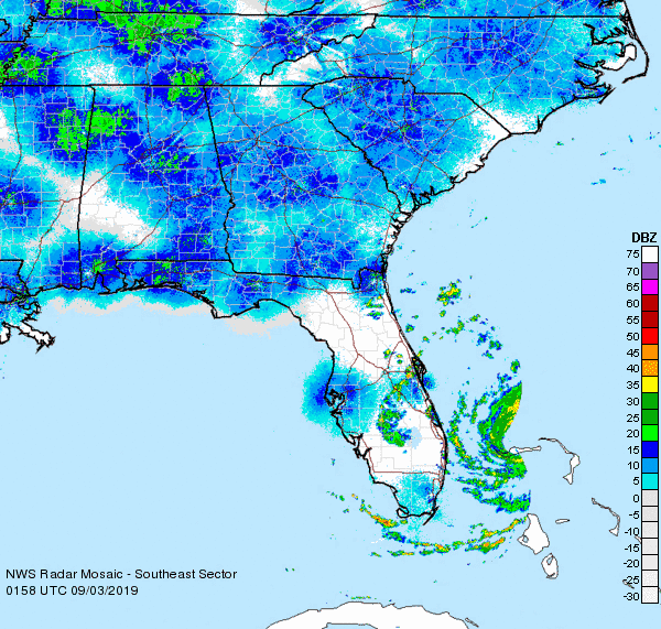
Black-throated Blue Warblers and Ovenbirds commonly winter on the Florida peninsula and in the Bahamas. With the major tropical cyclone Hurricane Dorian presently ripping through the region, these birds are better off taking their time getting there. There’s no need to hurry. The longer they and the other Neotropical migrants hang around, the more we get to enjoy them anyway. So get out there to see them before they go—and remember to look up.

There are two Conewago Creek systems in the Lower Susquehanna River Watershed. One drains the Gettysburg Basin west of the river, mostly in Adams and York Counties, then flows into the Susquehanna at the base of Conewago Falls. The other drains the Gettysburg Basin east of the river, flowing through Triassic redbeds of the Gettysburg Formation and York Haven Diabase before entering Conewago Falls near the south tip of Three Mile Island. Both Conewago Creeks flow through suburbia, farm, and forest. Both have their capacity to support aquatic life impaired and diminished by nutrient and sediment pollution.
This week, some of the many partners engaged in a long-term collaboration to restore the east shore’s Conewago Creek met to have a look at one of the prime indicators of overall stream habitat health—the fishes. Kristen Kyler of the Lower Susquehanna Initiative organized the effort. Portable backpack-mounted electrofishing units and nets were used by crews to capture, identify, and count the native and non-native fishes at sampling locations which have remained constant since prior to the numerous stream improvement projects which began more than ten years ago. Some of the present-day sample sites were first used following Hurricane Agnes in 1972 by Stambaugh and Denoncourt and pre-date any implementation of sediment and nutrient mitigation practices like cover crops, no-till farming, field terracing, stormwater control, nutrient management, wetland restoration, streambank fencing, renewed forested stream buffers, or modernized wastewater treatment plants. By comparing more recent surveys with this baseline data, it may be possible to discern trends in fish populations resulting not only from conservation practices, but from many other variables which may impact the Conewago Creek Warmwater Stream ecosystem in Dauphin, Lancaster, and Lebanon Counties.
So here they are. Enjoy these shocking fish photos.


SOURCES
Normandeau Associates, Inc. and Gomez and Sullivan. 2018. Muddy Run Pumped Storage Project Conowingo Eel Collection Facility FERC Project 2355. Prepared for Exelon.
Stambaugh, Jr., John W., and Robert P. Denoncourt. 1974. A Preliminary Report on the Conewago Creek Faunal Survey, Lancaster County, Pennsylvania. Proceedings of the Pennsylvania Academy of Sciences. 48: 55-60.