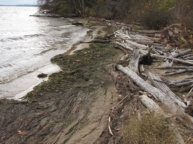
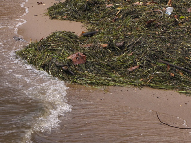
As they travel between coastal wintering ranges and breeding territories in Canada and Alaska, vast numbers of shorebirds pass through the lower Susquehanna region each spring and fall—though few stop here to rest, feed, and provide us with an opportunity to observe them. Prior to the construction of man-made dams and other alterations on our lotic (flowing) waterways including the river, shorebirds took advantage of lateral bars, stream deltas, and other alluvial deposits as places to loaf and re-energize. Before they were drained and filled, some of the valley’s wetlands probably included sparsely vegetated flats where shorebirds could drop in for a brief visit. Previous to their extirpation from our region, North American Beavers were the primary providers of quality habitat for shorebirds and other migrating waders on our lotic waters. Their widespread network of dams, pools, and marshes maximized floodplain function by keeping streams thoroughly connected to their wetlands, nurturing plant communities that not only provided food and shelter for the beavers and other wildlife, but provided superb buffering against erosion while protecting against sediment and nutrient imbalances in lower Susquehanna waterways.
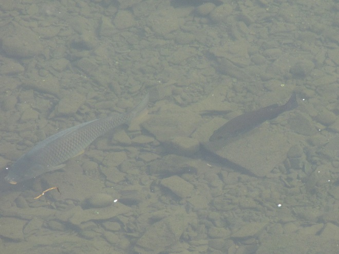
Beaver dams need not be large, particularly on low-gradient streams where a structure like this is sufficient to create a pool with depth adequate for building and maintaining a lodge and transporting leafy branches and other food items by water.A beaver lodge assembled in a pool with less than three feet of water, deep enough to provide the family with a measure of protection against terrestrial predators.Beaver pool ecosystems provide homes for hundreds of species of plants and animals, including migrating shorebirds and other waders.Mud flats in the margins between emergent shrubs and herbaceous plant growth attract migrating shorebirds like this Solitary Sandpiper to the abundance of invertebrate life. Seasonal movements of migrating shorebirds regularly coincide with the reductions of water levels in beaver pools which typically occur between May and September each year.During its southbound migration in September, a Least Sandpiper searches for arthropods and annelids as it visits a food-rich puddle along the periphery of a beaver pool.A Pectoral Sandpiper feeds in shallow water near a stand of Common Cattails in a beaver pool.During migration, rails including the Sora are attracted to dense emergent vegetation in beaver pools. Some will nest in these rodent-managed refugia.Green Herons visit beaver pools during migration and, due to the reliability of the food supply, will often nest in their vicinity.
So how did this happen? How did the North American Beaver become a keystone species—an animal upon which the majority of other life forms within its ecosystem are so reliant? Well, it’s largely due to the fact that our beavers aren’t particularly fond of a constant stream of noise. More specifically, they don’t like the sound of running water in places where they intend to build and maintain a lodge. And so, as they begin to place sticks, mud, limbs, stones, and other materials within a noisy riffle on a stream, they create a dam, and behind it a pool—a pool that is particularly advantageous for protecting their home and providing a means of conveyance for their construction materials and food supplies.
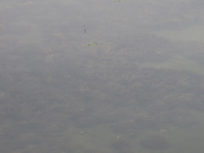
On a high-gradient segment of stream, beavers will create a cascading series of pools. Because water filters through a beaver dam instead of spilling over it, the work of these meticulous rodents soon silences the sounds of water changing altitude. No more sonorous riffle.Quiet please. High seasonal stream flow and damage from storms may create areas where water begins to erode the structure of the dam. Where this condition persists, an adult beaver will soon mend the breach, just to quiet things down. Why would beavers demand such a hush upon their domain? Well, they have poor eyesight, but their hearing is excellent, and they rely upon it to detect danger.The Louisiana Waterthrush (Parkesia motacilla), one of our earliest-arriving warblers, nests in forests along clear, high-gradient streams. In mid-April, we found this individual and three others squabbling over a breeding territory adjacent to the series of cascading beaver pools shown in the previous images.Native denizens of coldwater streams, neither the Brook Trout nor the Eastern Blacknose Dace has any difficulty finding its way through the voids in beaver dams to ascend and descend the sequence of pools.On a low-gradient segment of stream, a dam just over a foot in height may be sufficient to create a beaver pool of considerable size. Resembling the water-logged muskeg of the far north, well-established beaver pools form boggy habitats familiar to migrating shorebirds.Water levels in the pools usually drop along with the stream’s base flow as soon as the effects of the spring thaw and rain showers subside. Feeding areas in shallow water and on muddy ground are often revealed just in time for northbound shorebirds and other waders to stop by in late April and May. These conditions often persist through the growing season and the fall migration of these birds which begins as early as late June and sometimes extends into October.Where the pool inundates standing timber such as Red Maple and other species not used by beavers, the dead snags provide vital feeding areas for birds and other wildlife. Cavity nesters like this Tree Swallow seldom find suitable natural housing elsewhere.The mosaic of marshlands and braided stream channels within the beaver pool complex supports an abundance of aquatic life including these breeding Eastern Newts, seen here surrounded by the exuvia left behind following a massive hatch of alderflies (Sialinae). Alderflies are a stream inhabitant during their larval stage and are indicator of clean water conditions.A modern-day example of the way fully functional stream floodplains used to look in the Lower Susquehanna River Watershed. Though the pools may appear pond-like during the cooler and wetter months of the year, by summer the water levels behind the beaver dams recede as the base flow of the stream wanes. Now the true nature of the marsh, shallow pool, and braided stream complex is revealed. Unlike most man-made dams that set a fixed pool elevation regardless of flow by discharging water over the top of the structure or through a spillway or gate, beaver dams merely throttle the flow through their porous construction. Unless the beaver begins plugging small leaks as fast as the stream flow ebbs, the water level in the pools will drop. So they’re not left high and dry, lodges are located in the deepest pools, usually in close proximity to the dam and/or one of the stream courses. Though not inundated during the dry season, the soil in the pool complex is almost always damp and plants grow vigorously there, sequestering nutrients and retaining sediments in beneficial deposition patterns that actually inhibit erosion of the riparian landscape. These streams and floodplains retain their hyporheic zone and freely exchange water with the underlying water table and aquifer. It’s the ultimate floodplain management system, and the beavers don’t even know their doing all the work. (Google Maps base image)Where another high-gradient segment of stream enters the main pool complex, beavers have created an additional series of cascading pools. The impoundments created by these dams help diffuse stormwater energy and process more nutrients and sediments within the floodplain’s wetland vegetation system. (Google Maps base image)Beaver pools often refill as stream flows increase following autumn rains. The stockpiles of vegetative foods that grew within the beaver’s domain through the summer then become flooded and are a prime source of nutrition for not only the beavers, but waterfowl during both their autumn and spring migrations. Gleaning and probing Sandhill Cranes often find these habitats to their liking as well.
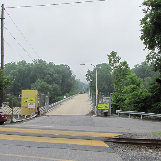
While North American Beavers have returned to the region, most live as “bank beavers”, residing in the river and larger creeks of the valley where they excavate shelters among the roots of Black Willows and other shoreline trees and shrubs. Floodplain encroachment, legacy sediment deposits, and just plain human intolerance have all conspired to prohibit North American Beavers from performing their magic on smaller local streams. For migrating shorebirds, this continued absence of beaver dam ecosystems has turned much of the lower Susquehanna valley into “flyover country”. Those travelers that do stop to rest and feed concentrate at the few favorable locations such as the lateral bars and the hydroelectric dam-created delta at the Conejohela Flats on the river in Lancaster County. But centralization has its drawbacks. Migrants spending time at concentration points may have a greater chance of contracting and spreading disease. Protracted heavy foraging can degrade these habitats. And over time, features such the lateral bars and delta deposits, including those on the Conejohela Flats, transition into other habitats—riparian forests. A more widespread selection of favorable stopover points for shorebirds, waders, waterfowl, and other migrants is certainly desirable.
IMITATION IS THE SINCEREST FORM OF FLATTERY
Until public sentiment sways in favor of the North American Beaver, wildlife managers are mimicking some of the attributes of their sound-inspired installations.
Created by excavating a depression in heavy clay soils, this new impoundment at the Pennsylvania Game Commission’s Middle Creek Wildlife Management Area collects water directly from rainfall and from surface runoff. Its depth at no point is greater than about two or three feet. During the driest times of the year, this space will be a mudflat, and a haven for migrating shorebirds.
Shallow-water conservation impoundments designed, constructed, and managed for migratory waterfowl and waders including shorebirds are not what we typically refer to as ponds—though they are lentic (still) waters. Similar shallow freshwater impoundments at our National Wildlife Refuges are referred to as pools by the United States Fish and Wildlife Service, but smaller versions like this example at Middle Creek very closely resemble the prairie potholes created by glacial scour in the north-central United States and adjacent portions of Canada. Many populations of migratory birds are familiar with pothole ecosystems and, like the beaver pools and marshes, have relied upon them as waypoints along their journeys for centuries.
Impoundments most beneficial to migrating waterfowl and waders including shorebirds are shallow in depth. They lack the deeper waters of a pond or lake and thus have no limnetic (open water) or aphotic zones. Managed throughout as a littoral zone, impoundments grow plants in shallow water or on damp soil through the summer months to chew up nutrients accumulated in waste deposited by visiting birds. This vegetation is then flooded from late fall through early spring as forage habitat for migratory waterfowl. The timing of the fluctuations in water levels approximates those of the beaver pools and marshes on lotic (flowing) waters.A gate assembly is a water control structure installed to provide seasonal management of the water levels in a conservation impoundment. More than once, beavers have heard the sounds of tumbling waters inside these types of devices and tried to dam them up!
You’ve heard the line, “If you build it, they will come.” Well, it’s true. Here is a sample of the activity witnessed during the past two weeks at the new impoundment completed just several months ago at Middle Creek Wildlife Management Area along the tour route just beyond the “Stop 3” overlook.
The ubiquitous Snow Geese were among the first migratory occupants of the new impoundment. A few are currently lingering in the vicinity.Ducks soon followed. These Blue-winged Teal were among the last to pass through earlier this month.Wilson’s Snipe were among the first species of migratory shorebirds to visit the new impoundment at Middle Creek……as were Killdeer, a species which nests nearby.Then, earlier this month, flocks of shorebirds including these Least Sandpipers were arriving to feed and rest.Least Sandpipers search for small invertebrates in shallow water and exposed soil.A Least Sandpiper (left) and a Semipalmated Sandpiper (right).Not all shorebirds seen by themselves are alone, and that includes the Solitary Sandpiper.Here’s a Solitary Sandpiper (right) feeding alongside a Least Sandpiper (center) and a White-rumped Sandpiper (left).A Least Sandpiper (left) and a White-rumped Sandpiper (right).Rare in our area during spring, the White-rumped Sandpiper (Calidris fuscicollis) flies north using the central flyway, then heads south along the Atlantic flyway in the fall, when it tends to be more regular here.Rocking and teetering along as it looks for food, the Spotted Sandpiper may be one of the easiest of shorebirds to identify.Chunky little Dunlin (Calidris alpina) with their conspicuously down-curved bills are another easy-to-identify species, particularly in the spring when their breeding (alternate) plumage includes a black belly.Black-bellied Plovers acquire a handsome set of plumage in the spring as well.Killdeer too are plovers and this pair appears to have taken up residence on barren ground along the periphery of the new impoundment.The Semipalmated Plover doesn’t have nearly the flair for ornament its close relatives the Killdeer do; these little shorebirds wear only one ring around their neck instead of two. Think this plover is cute?,……then check out this newly hatched Killdeer. It starts life with just one necklace too, but acquires a second as it grows. Look at those legs! (If you visit the new impoundment at Middle Creek, drive slowly and please watch where you’re going. Baby Killdeer and other young birds, as well as mammals and turtles, are commonly crossing the paved surfaces right now.)Speaking of legs, here’s one of dozens of Lesser Yellowlegs that visited the new impoundment during their recent northbound travels.Though less numerous than the smaller Lesser Yellowlegs, a Greater Yellowlegs seldom goes unnoticed when dropping by the man-made pothole habitat.Have trouble telling a Greater Yellowlegs like this one from a Lesser Yellowlegs? Look for the heavier, longer bill on the former, as well as dark barring along its flanks below the wings while the bird is in breeding (alternate) plumage during the spring migration.Everyone likes to see something unusual every now and then, and this impoundment delivers. Just yesterday, we photographed this migrating Wilson’s Phalarope (top center) among two Least Sandpipers (top left and right), a Lesser Yellowlegs (left and slightly forward of the phalarope), and a White-rumped Sandpiper (foreground).Renowned for spinning in circles as they feed in shallow water, Wilson’s Phalaropes (Phalaropus tricolor) passing through the lower Susquehanna basin are headed toward nesting areas in the prairie wetlands, including potholes, of the northern United States and adjacent sections of southern Canada.
Species of wildlife in addition to shorebirds and waterfowl have already found the new impoundment favorable…
Pairs of breeding Spot-winged Gliders (Pantala hymenaea), seen here in tandem while ovipositing, were swarming the impoundment after arriving earlier this week. These dragonflies are ofttimes unpredictable nomads and are similar in appearance to the usually more numerous Wandering Gliders. To recolonize seasonal portions of their range, both are famous for hitching a ride en masse on storm systems. They share the behavior of finding ephemeral and new bodies of water favorable for egg laying due to their low density of aquatic predators.We watched this Snapping Turtle arrive to apparently find the newly created waters to its liking. Snapping Turtles are important consumers in a wetland ecosystem. Larger specimens may fill the role of an upper trophic level or apex predator, eliminating vulnerable mid-level consumers including other Snapping Turtles.Because it bounces its tail up and down like a Spotted Sandpiper, you may at first glance mistake an American Pipit for a shorebird. Long known as the Water Pipit, these songbirds have been visiting the impoundment while migrating north and stopping to feed in nearby croplands.Seen here with Least Sandpipers is a visiting Glossy Ibis.Sometimes twenty or more of these mostly coastal waders have made a pit stop at the “new Middle Creek pothole”, though none have thus far chosen to remain long. Apparently, food sources sufficient to sustain a bird of their size have yet to develop in its benthos.Western Cattle Egrets visiting Middle Creek this spring have been frequenting the new impoundment.With still little in the way of insects such as grasshoppers available in the surrounding landscape,……cattle egrets are looking to find prey like this Green Frog.Many have been observed hunting the adjacent grasslands..Where small mammals, mostly Meadow Voles, are being taken in abundance.
Managing saturation levels in shallow-water impoundments to resemble the seasonal variations in beaver pool and marsh systems can create lush growth and wildlife-rich environments. Take a look at some images from a project in a headwaters area of a tributary to Conewago Creek (west)…
By late July, southbound shorebirds were already using these mudflats to feed and rest. Other sections of the impoundment were dense with emergent and aquatic plants, the latter kept hydrated in deeper pools of the project by the inflow from several captured springs that supplement direct rainfall and sheet runoff to supply its water. During a seasonal drawdown, the exposure of the impoundment’s soils to direct sunlight can provide a measure of disinfection to reduce the chances of disease transmission among its populations of visiting birds and other animals.In the deeper pools of the impoundment, water lilies and other aquatic plants grow in lush mats to provide cover and feeding areas for resident populations of breeding reptiles and amphibians.An abundance of foods are available for waders including this Green Heron……and this immature Little Blue Heron, a wanderer typical of more southern latitudes.While walking the road among tall grasses in the supporting landscape surrounding this impoundment, we were at first startled when these Sandhill Cranes strode by going the other direction. We quietly kept moving,……then spotted them again as we looked across the impoundment to realize they weren’t alone, but were escorting a colt.The hatching of this colt is testimony to the vital role wetland ecosystems play in the lives of hundreds of species. Whether they be beaver pools and marshes on lotic waters or man-made shallow lentic waters, each of these habitats is filling a void that left floodplains and other critical lowland biomes faltering. While they can’t replace the full-function floodplain management provided by an active beaver colony, shallow-water impoundments can provide relief for habitat-starved populations of the animals and plants that rely upon them. A constellation of these projects on lands public or private across the lower Susquehanna watershed could help provide refuge for many of our flora and fauna with the most desperately fragmented of ranges.
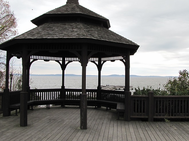
So that you can relax while observing the comings and goings at a pair of the lower Susquehanna valley’s man-made impoundments, the Pennsylvania Game Commission has erected two viewing pavilions for public use on its lands…
The Haldeman Island observation pavilion is located on State Game Lands 290 just upstream from the Juniata River’s mouth on the Susquehanna at Clark’s Ferry in Dauphin County.It overlooks not only the island’s man-made shallow-water impoundments and neighboring grasslands, but the hacking tower used in the 1970s to reintroduce Bald Eagles from Saskatchewan to the lower Susquehanna. Interpretive signs explain the conservation stories of habitats and the eagle reintroduction program.The observation pavilion at Middle Creek Wildlife Management Area is of similar construction to the one at Haldeman Island. It is accessed from the parking pull-off along the tour road at its intersection with Chapel Road, just before the right turn and incline that leads to the “Stop 3” grassland overlook.It too includes numerous interpretive signs to help visitors understand impoundment management.
During the next two weeks, the exodus of migrating shorebirds now staged and feeding upon Atlantic Horseshoe Crab eggs on Delaware Bay will commence. During the evening of their departure from the bay, many of these birds cross portions of the Lower Susquehanna River Watershed, particularly east of the river. Stormy weather and other climatic conditions may force some of them to seek a place to put down temporarily, so keeping a close eye on the new pothole-like impoundment at Middle Creek may be a prudent move. After that, waders known as “post-breeding wanderers” can show up at any time. Then, beginning as early as late June, shorebirds begin moving south on a migration that can provide us with viewing opportunities into September and beyond. See you out there!
Some comparative attributes of unspoiled lotic vs. lentic freshwater ecosystems. Low-gradient (slow-moving) lotic waters often create, and remain connected to, accompanying riverine wetlands (a lentic freshwater ecosystem). These swamps, marshes, and ditches absorb, purify, and infiltrate flood waters while supporting a diverse number of plant and animal species.
We frequently perceive all waterfowl migration to be synchronized with the conspicuous movements of familiar species like Snow Geese, Tundra Swans, and Canada Geese—big flights coming south in October and November, then a return to the north in late February and March. And we’re all quite aware of the occurrence of large gatherings of some of these migrants while they make stopovers on some of our largest lentic (still) waters—the man-made lakes and reservoirs created by damming local streams. But did you know that there are populations of colorful waterfowl with dynamic migrations that extend throughout the winter and early spring with movements that are often continuous. Under favorable conditions, these birds favor the lotic (flowing) waters of the river and its larger tributaries as they transit the lower Susquehanna valley. That’s because unpolluted lotic freshwater ecosystems support a greater diversity of plants and animals than lentic waters, and therefore offer more opportunities for hungry migrating waterfowl to find food. Let’s have a look at some of the species that visit the river during their seasonal journeys…
While the urge to head south in the autumn is largely stimulated by the shortening of the photoperiod, it is the presence of ice, particularly on glacial lakes throughout the lands to the north of the lower Susquehanna River basin, that pushes many diving ducks to finally make their way south toward the guarantee of open-water feeding areas along the coast. This movement may occur at anytime between November and late February or, as we have seen during some of the mild winters of recent decades, it may scarcely be noticed at all.Common Mergansers often lead they way when it comes to migratory diving ducks. They regularly move south in conspicuous numbers by late November and December and are regularly pushing north as soon as the ice begins to melt. During a typical year, it is not unusual for some populations of these large diving birds to remain north of us during the winter. Then, in the days after a sudden rush of frigid polar air, an appreciable increase in ice cover will force a mid-winter movement of birds down the Susquehanna.Temperatures in lotic fresh waters vary over the length of the stream or river. They are largely determined by the collective impact of the numerous sources of heat flux depicted in this graphic. (Environmental Protection Agency image)Buffleheads begin passing through the lower Susquehanna region in Novemeber on their way to coastal saltwater bays for the winter. Lingering populations feed by diving in the river’s pools and riffles for benthic invertebrates including snails and insect larvae. Lesser quantities of aquatic plant matter supplement their diet.Many Common Goldeneyes will remain on shallow, ice-free waters of the northern lakes and rivers sculpted by the most recent glacial event, but only until they are forced south into and through the lower Susquehanna valley by the encroachment of freezing conditions. On the river, they are among the dozen or so species of diving ducks we see visiting or passing through during the typical late fall and early river.
During their visits to the lotic (also known as riverine) fresh waters of the Susquehanna and its largest tributaries, benthic-feeding waterfowl make short dives to take advantage of the plants, small fish, invertebrates, and other food sources inhabiting the stream bottom in the riffles and pools of the free-flowing waterway. Substrates, listed here by size (in descending order), along with other parameters influenced by this flow regime zonation determine the variety and abundance of the forage available to migrating waterfowl and other consumers. Ice or high water and poor visibility due to flooding can render the riffles and pools of the channel unusable for feeding. The birds must then choose to either linger and rest without feeding or leave the lotic freshwater habitat to seek sustenance. During a flood, this may require relocation to a nearby lentic (still) body of fresh water such as a lake or reservoir. The presence of ice will almost invariably force the birds to fly on to the Atlantic Coastal Plain and the tidal waters of its bays and estuaries.Hooded Mergansers are one of the few species of diving ducks likely to utilize flooded shoreline timber and riverine (fluvial) wetlands as refuge from high water on Susquehanna.A Pied-billed Grebe and a pair of Canvasbacks on an ice-free stretch of the lower Susquehanna in mid-winter feed and loaf in a riffle-flanked pool where a large mat of American Eelgrass, a submerged aquatic plant also known as Tapegrass or Wild Celery, grows during the summer. The vast mosaic of riffles and pools in a river this size offers tremendous opportunities for a diverse array of aquatic species to find their niche wherein they can survive and flourish.The presence of ice forces Buffleheads and other diving ducks to gather in turbulent open water, often below a riffle or dam. Another alternative is to continue on toward the salty bays and estuaries of the coast. High water may push these birds into the shallows among the flooded woods to feed, but they seldom utilize heavily forested riparian wetlands as a refuge due to their need for a running start to get airborne.
Riffle and Pool Characteristics of High Gradient (A) and Low Gradient (B) Streams. This graphic illustrates the change in deposition characteristics of a stream or river as its gradient decreases. A high-gradient stream (A) has a rapid velocity, often forms falls, and tends to carry away a high volume of all but the largest of particles of potential substrates as they erode from the surrounding landscape. On a low-gradient stream, the loss in water velocity reduces the water column’s ability to transport even the smallest of substrate particles. Deposition of this gravel, sand, silt, and clay forms lateral bars that over time create the familiar meandering path of a naturally flowing lowland stream. (National Park Service image)Benthic substrates in lotic freshwater pools and riffles support an abundance of life forms ranging from colorful diatoms on rocks and cobble, to invertebrates including snails and insect larvae, to fishes like this young Channel Catfish. Free of accumulations of sediment, this river bottom not only provides habitat for a healthy fishery, it facilitates the bidirectional exchange of water between the Susquehanna and its underlying aquifer.On the lower Susquehanna, populations of young Quillback suckers are found almost exclusively in clear, high-gradient pools.The Harlequin Duck winters along the rocky shores and man-made jetties of the Atlantic coast. In summer, they nest on fast-moving, headwater streams well to our north. Very rare on the Susquehanna, this is the first of two individuals found during March and April of 2025. It was observed feeding in the swift waters of the high-gradient riffles and pools where the river cuts through Blue Mountain north of Harrisburg. During previous weeks, Harlequin Ducks were being seen along the coast as far south as the mouth of the Chesapeake at Cape Charles, Virginia. It’s very possible that some of these birds traveled north through the bay area and up the Susquehanna on their way north.
Fluvial Geomorphology of a Stream. Many of the Susquehanna’s tributaries pass through each of these three erosional zones. Along the way, they carry out the process of breaking down the mountains formed by the Allegheny orogeny, the collision of North America and Africa that created the supercontinent Pangea about 325 to 260 million years ago (during portions of both the Carboniferous and Permian periods). Today’s main stem of the lower Susquehanna passes through a transfer zone (Zone 2), carrying eroded materials to a depositional zone (Zone 3) located within the ancient Susquehanna canyon stretching from Havre de Grace, Maryland, to Norfolk Canyon on the edge of the continental shelf. Within this zone, more than a 10,000-year accumulation of post-glacial sediments lies submerged by the rising waters of the Atlantic Ocean and Chesapeake Bay. Although the present-day lower Susquehanna is largely a transfer zone, some deposition occurs along low-gradient segments of the river, particularly where its course parallels the watershed’s ridges both above and below the high-gradient rapids where its path has eroded passage through the highlands. (National Park Service image)Although the present-day lower Susquehanna is largely a transfer zone, some deposition occurs along low-gradient segments of the river, particularly where its course parallels the watershed’s ridges both above and below the high-gradient rapids where its path continues to erode passage through the bedrock. On this 1908 map of the Susquehanna at Conewago Falls, alluvial terraces of gravel, sand, silt, and clay can readily been seen as pale areas nearly lacking brown contour lines along the shorelines and islands of the river. Deposits within most of these terraces date back to the melt period following the most recent glacial event and beyond. The delta shown at the mouth of Conewago Creek (west) includes massive volumes of material deposited by both the creek and the river. This delta is currently known as Brunner Island, much of it developed as the site of a coal/gas-fired electric generating station. Terrace deposits along the Susquehanna’s shorelines created extensive perched marshes and swamps (wooded marshes) fed by rains, high river water, small streams, and springs, the latter often seeping from the base of the rocky escarpments carved by the ancient Susquehanna and defining the present-day inland border of the floodplain. We call these sites “Alluvial Terrace Wetlands”. Few of these critical components of river morphology survive. Those not drained for farmland were obliterated by urbanization and canal, railroad, and highway construction. (United States Geological Survey base image: Middletown, PA, quadrangle, 1908)Water Willow is a familiar emergent plant that colonizes lateral bars and other alluvial deposits in low-gradient segments of the Susquehanna.The fine roots of Water Willow collect sediment and absorb nutrients while creating dense cover for young fish and numerous species of invertebrates including the Virginian River Horn Snails seen here.
Prior to the nineteenth century, the low-gradient flow regime of the river both above and below the riffles at Chiques/Chickies Rock (lower right on map) created prime wildlife habitat. The natural accumulations of nutrients and substrates carried into and through the lotic waterway’s pools and riffles were cycled into an ideal growing medium for extensive mats of American Eelgrass and other aquatic plants. This underwater forest hosted a seemingly endless abundance of invertebrates and fishes (both resident and migratory)—supporting a variety of consumer species including various populations of humans. But soon after the mass clearing of much of the watershed’s land for farming and lumber, the mill ponds created by dams constructed on streams to power saw and grain mills became brimful with sediments eroded from the unprotected ground. During storm events, torrents of these sediments then flowed full bore toward the Susquehanna, and began accumulating in the low-gradient segments of the river.
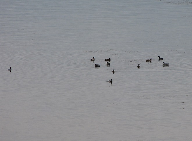
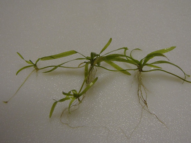
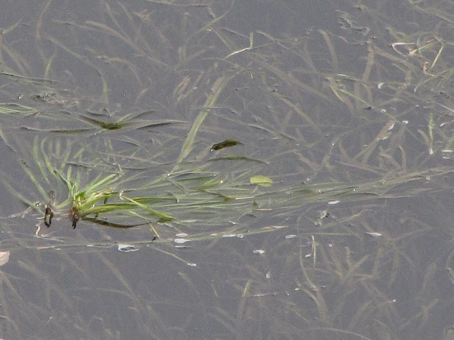
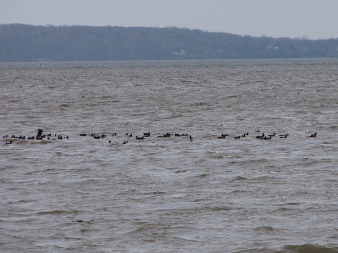
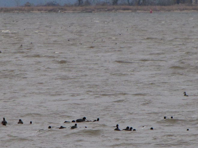
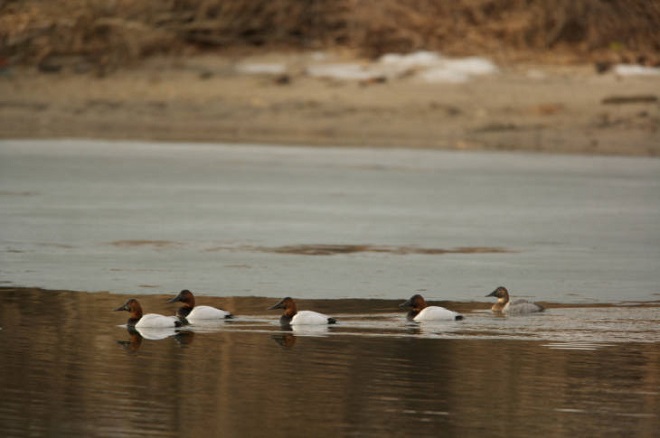
Sediments left behind after the removal of mill dams are known as legacy sediments. They disconnect the stream from its historic floodplain and riverine (fluvial) wetlands, thus intensifying the impact of high water in the surrounding landscape. As these nutrient-charged deposits wash away, they become a source of pollution in the waters of the Susquehanna and Chesapeake.A mat of American Eelgrass growing in the flowing waters of the Susquehanna below Conewago Falls. Eelgrass and other submerged aquatic plants provide essential habitat for a wide variety of small fish and invertebrates while also consuming nutrients deposited in the cobble, gravel, and sand substrate of the river’s pools. Excess quantities of smaller particles of silt and clay can clog the substrate and thus inhibit the hyporheic exchange of water between the stream channel and the underlying aquifer, often diminishing the biomass and diversity of organisms inhabiting this benthic habitat. Buried in these life-choking sediments, the river bottom becomes inhospitable to growth of submerged aquatics including eelgrass.This low-gradient stretch of the Susquehanna at Marietta flows parallel to the Chickies Quartzite “Hellam Hills” before making a sharp right turn to punch through the ridge as a series of rapids at Chiques Rock. Formerly a fully functional lotic ecosystem and a paradise for migrating waterfowl, this river segment is now impaired by accumulations of nutrient-laden sediments from agricultural and urban runoff.Nutrient and sediment-loaded flood waters roar across the diabase boulders at the York Haven Dam and Conewago Falls, a high-gradient segment of the Susquehanna.They continue past Brunner Island (left power plant stacks) and through Haldeman Riffles and the Shocks Mills Railroad Bridge……into the stretch of river known as the “Marietta broads” along the base of the Chickies Quartzite “Hellam Hills”. The low stream gradient here produces a slower current and increased deposition of sediments.As the flood surges through the riffle and pool complex at Chiques Rock, the high stream gradient maintains a velocity in the water column sufficient to keep additional sediments in suspension until they reach the low-gradient river segment just downstream at Washington Boro, site of a naturally occurring lateral bar area known as the Conejohela Flats. These bars now lie within the man-made depositional zone known as “Lake Clarke”. Created nearly a century ago by construction of the Safe Harbor Dam, this impoundment is accumulating astounding volumes of nutrient-loaded sediments that continue to encapsulate the flats within a stream-impairing delta.Anytime from November to April on the lower Susquehanna, a group of Redheads, Canvasbacks (3 birds to right of the middle of the picture), and a Horned Grebe (lower left) is a welcome sight in a riverine pool known to have a summertime growth of American Eelgrass. Noted Dr. Herbert Beck in 1924 when describing the Canvasback, “Like all ducks, …, it stops to feed within the county (Lancaster) less frequently than formerly, principally because the vast beds of wild celery which existed earlier on broads of the Susquehanna, as at Marietta and Washington Borough, have now been almost entirely wiped out by sedimentation of culm. Prior to 1875 the four or five square miles of quiet water off Marietta were often as abundantly spread with wild fowl as the Susquehanna Flats are now. Sometimes there were as many as 500,000 ducks of various kinds on the Marietta broad at one time.”Today, seeing just dozens of Aythya genus ducks (Redheads, Canvasbacks, scaup) on the lower Susquehanna is a notable event. If they happen to be forced down by inclement weather while migrating through, you might get lucky enough to see several hundred.While the recovery of eelgrass/wild celery beds on the Susquehanna is trivial in scale and offers little support for numbers of waterfowl to return to historic levels, restorations on the upper Chesapeake in the vicinity of the Susquehanna Flats between Havre de Grace and Aberdeen Proving Grounds may have helped refuel a gathering of mostly Aythya genus ducks during the final days of February. This mass of ducks, many of which were forced south from the frozen Great Lakes during the previous weeks (some by way of the ice-choked Susquehanna) were apparently making an abrupt turn to make their way back north. Their stay was brief, but estimates by local birders put their numbers as high as one half million. The vast majority of the concentration consisted of Aythya species: Redheads, Canvasbacks, Ring-necked Ducks, and both Lesser and Greater Scaup. It probably included a mix of birds including both northbound migrants from further down the coast and the aforementioned refugees that had just arrived to pay a quick visit while escaping the late-season ice before turning around.During the past two centuries, as food supplies in the Susquehanna grew increasingly compromised for benthic feeders like these Lesser Scaup and other diving ducks, a change in distribution was necessary for survival.As individual species, Lesser Scaup and other waterfowl that fail to adapt to natural or man-made changes in their habitats and food supplies may see their overall global numbers falter.
Despite being located in the transfer zone, the lower Susquehanna has become a significant depositional zone along much of its length, mostly courtesy of the placement of sediment-trapping man-made dams.
Following construction of the mill dams and ponds on nearly every mile of the lower Susquehanna’s low-gradient tributary streams, enterprising parties moved on to the river. The first significant spans were constructed using wide timber cribs filled with large rock. They were placed to create water deep enough to allow canal boats to cross the Susquehanna at both Clark’s Ferry at the mouth of the Juniata River in Dauphin County and at Columbia/Wrightsville. These dams also diverted water into the newly excavated canals—the Pennsylvania Eastern Division Canal (completed in 1833) which followed the river’s east shore from Clark’s Ferry to Columbia, and the Susquehanna and Tidewater Canal (completed in 1840) along the west shore from Wrightsville to Havre de Grace, Maryland. Placement of these sediment-trapping man-made dams began a process of converting vast mileage of the lower Susquehanna from a transfer zone into a deposition zone. In addition, layout of the canals and locks followed the contours along the base of the riverside ridges, seriously altering most of the alluvial terrace wetlands that the river had created as a feature of its floodplain during the post-glacial period.
Construction of the canal dams was just the beginning. During the twentieth century, more massive dams would be added to the main stem of the river for hydroelectric energy production at York Haven, Safe Harbor, Holtwood, and Conowingo. Upon their completion, the days of unassisted anadromous fish migrations were over. On both the river and its tributaries, smaller dams including dangerous low-head dams maintain water levels for boating and recreation. They too create current-diminishing, pseudo-lentic waters that blanket the lotic riffle and pool substrates with polluted sediments.
MAN-MADE DAMS TURN LOTIC WATERS INTO UNFLUSHED TOILETS
The construction of dams on the lower Susquehanna has converted vast mileage of the river from a lotic freshwater system into a series of man-made lentic freshwater reservoirs. These areas have lost their function as a lotic transfer zone and are now a sort of dysfunctional series of depositional zones collecting vast volumes of sediment containing nutrients and other pollutants. Within each impoundment, the reduced velocity of the river causes it to drop suspended sand first, then the finer particles of silt and clay closer to the dam. The flow regime of riffles and pools is lost and the hyporheic zone that exchanges water between the river and the underlying aquifer is clogged. These impaired segments of river become ripe for eutrophication: algal blooms followed by die offs that can lead to a fatal reduction of dissolved oxygen in the water column.Deposits of lateral bars of sediment in low-gradient segments of the Susquehanna can create shallow water feeding habitat for puddle/dabbling ducks like these Gadwall. Where sediment pollution is severe, benthic foods in these areas often consist mostly of invertebrates and plant matter deposited by the current, the buried substrates devoid of a functioning ecosystem and the waters subject to eutrophication.Common Goldeneyes on a patch of open water on an otherwise ice-covered “Lake Clarke”, the impoundment created by Safe Harbor Dam. While they may find this spot advantageous for loafing, the food supply over the sediment-buried substrate will be limited.
Dredging of sections of the lower Susquehanna for spilled, discarded, and washed-out anthracite coal sediment went on for nearly 100 years and was a particularly active enterprise in the Harrisburg area and in Lake Clarke until 1973. The recurrent substrate disturbances that accompanied waste coal recovery in these segments of the river repetitively damaged habitat for benthic life and may have been the catastrophic factor leading to the extirpation of two species of freshwater mussels: the Eastern Lampmussel (Lampsilis radiata) and the Dwarf Wedgemussel (Alasmidonta heterodon).
By the end of the twentieth century, accumulations of polluted sediments behind lower Susquehanna dams were nearing capacity. There is no working plan to attenuate the massive release of these pollutants that may be triggered by a catastrophic flood. The effort to reduce nutrient and sediment runoff remains the focus so that new loading is kept to a minimum and won’t add to the capacity problems at the dams or continue downriver to the Chesapeake at full strength when the dams are full. Alleviating the sediment aggregation problem within the river’s impoundments is a tall order and a dilemma not easily solved. (United States Geological Survey image)Common Mergansers will feed where benthic substrate supports the small fish and invertebrates they prefer. They will, however, gather in extraordinary numbers on the “lakes” created by riverine dams. Though they can only feed on what floats in with the current, hundreds or sometimes thousands of Common Mergansers will concentrate on “Conowingo Pond” during the late fall or early winter. There, safety in numbers gives them some guarantee of protection against the multitudes of eagles that simultaneously frequent the vicinity. Another advantage of staging on “Conowingo Pond” is its close proximity to favorable feeding areas on upper Chesapeake Bay and stretches of the Susquehanna where lotic riffles and pools offer abundant opportunities below the river’s dams.Fortunately for everything else living in the benthos, Common Mergansers are big enough to devour invasive, non-native Rusty Crayfish when they find them in our lotic waterways.
TIME TO CLEAN UP OUR ACT
WHERE DOES YOUR STORMWATER GO?
Channelized Urban/Suburban Streams Function as Sewers. They have no attached lowlands or floodplains to absorb, purify, and infiltrate runoff from rain events. Pollutants including litter, pet waste, lawn chemicals, tire-wear particles, hazardous fluids, and sometimes untreated human excrement flush unchecked from the municipal storm drainage system into the waterway. Thermal shock from summer downpours washing across sun-heated pavements can kill temperature sensitive fishes and other aquatic life. Nutrient and sediment loads from these impaired tributaries later accumulate downstream in low-gradient segments of the Susquehanna, turning the river into an open-air cesspool. Aggressively working to implement projects that eliminate these sources of pollution are the only effective way to keep the problem from getting worse. Making things better requires a lot more dedication and effort. (United States Geological Survey image by Frank Ippolito)
RIPARIAN BUFFERS MAKE A DIFFERENCE…WIDER IS BETTER
To sequester sediment and cycle nutrients (primarily nitrogen and phosphorus) contained in farm runoff, the U.S.D.A. recommends installing riparian buffers between streams and lands used for grazing and raising crops. To protect pollinating species including bees and butterflies from pesticide drift and eroding soils rich in fertilizers, they further recommend installing a stand of wind-pollinating plants such as conifers, oaks, and birches between the field and streamside plantings. These same conservation practices improve water quality and wildlife habitat on waterways located in residential and commercial areas as well. (United States Department of Agriculture image, click to enlarge)
FLOODPLAIN RESTORATION
Regardless OF HOW LONG YOU’VE BEEN CONDITIONED TO THINK OTHERWISE, THIS IS A DYSFUNCTIONAL, POLLUTED CREEK—AND IT NEEDS HELP
A channelized low-gradient stream eroding a path through deposits of legacy sediments displaces flood waters into previously unaffected areas and provides a continuing source of nutrient and sediment pollution during storm events. These impaired waters have a diminished capacity for supporting aquatic life including fishes.
RESTORED TO ITS HISTORIC FUNCTIONS
On an adjacent segment of the same creek, this legacy sediment removal project restored a braided meandering channel and connected it to its newly liberated, historic floodplain. In just their second year, the fluvial wetlands are effectively absorbing stormwater and sequestering nutrients as an attached component of the stream’s riffle and pool complex. During our visit earlier this week, we found American Toads, Northern Leopard Frogs (Lithobates pipiens), and Northern Spring Peepers breeding here. It’s just as Castor canadensis would have it!
“STOP HEMMING AND HAWING AROUND ALREADY”
“HEY COWBOY, HOW ‘BOUT GETTIN’ THEM FILTHY LITTLE DOGIES OUTTA DAT CRICK?”
Here’s a polluted stream in a pasture with grazing livestock. The site is a former mill pond within which the creek eroded a channel following removal of the dam. The animals defecate and urinate where access to water is gained at a broken down embankment of the nutrient-loaded legacy sediments deposited in the pond more than a century ago. It’s a haphazard form of animal husbandry and a reminder that all it takes is just one stubborn jackass to foul up the whole waterway.
DIRECT SOURCES OF NITROGEN (AMMONIA) POLLUTION IN STREAMS
DID YOU KNOW that a dairy cow produces about 80 pounds of waste (excrement and urine) every day?
DID YOU KNOW that a horse produces about 50 pounds of waste (excrement and urine) every day?
DID YOU KNOW that a human produces about 3 to 4 pounds of waste (excrement and urine) every day? The exceptions, of course, are those who continue to insist that raising farm animals in and alongside a body of water is okey-doke—a harmless practice. These individuals tend to retain the former constituent of human waste and are thus full of it.
“ATTABOY TEX, THAT’S MORE LIKE IT!”
Now that’s better. Legacy sediments have been removed to reconnect the stream to its floodplain. A livestock crossing and exclusion fencing has been installed, and a nutrient-consuming riparian buffer has been planted. This creek segment’s pollution woes have been mitigated. Do you have a neighbor needing this type of remedial work on their farm? Encourage them to contact your local county conservation district office or volunteer waterways restoration organization for assistance. Various programs provide financial assistance covering all or most of the costs of stream improvement as well as monetary incentives for helping to clean up the water.
AND FINALLY
WHEN IT COMES TO BUILDING DAMS ON LOTIC FRESH WATERS…
…LEAVE IT TO THE BEAVERS
North American Beavers (Castor canadensis) create habitats that connect the riffle and pool regime of a low-gradient stream to a surrounding fluvial wetland that retains sediments, cycles nutrients, and provides essential habitat for hundreds of plant and animal species. Floodplains are for flooding, and if a beaver floods an area, you can be guaranteed that it was already part of a floodplain. You see, beavers don’t encroach upon humans, it’s humans engaging in the encroachment upon beavers. (National Park Service image)
MAD HATTERS
DID YOU KNOW that even before the landscape was cleared for farms and a supply of timber, and before mill dams on local creeks began accumulating soil runoff from the consequently barren hillsides, all the North American Beavers, the keystone species of lower Susquehanna stream ecology, were killed and sold to make hats? It’s no wonder things are fubar!
COMING SOON…
Horned Grebes are regular migrants and sometimes winter residents on ice-free stretches of the lower Susquehanna. They spend their time plying the benthic substrate of the river’s clear riffles and pools for a variety of invertebrates and small fish. Look for them moving north in coming days sporting this beautiful breeding plumage.April and early May are prime time for observing Common Loons on the Susquehanna as they undertake a journey from the Atlantic surf where they spent the winter to nesting sites on northern lakes. For this migrant in breeding plumage, clear water for sighting plenty of benthic life in the river’s riffles and pools assures a successful dive in search of energy-replenishing forage.
Soon after their arrival during the late 1600s, the earliest trans-Atlantic human migrants to settle the Lower Susquehanna River Watershed began the process of eliminating many of our largest native fish species. They started by extirpating nature’s steward of lowland streams and wetlands, the North American Beaver. The beaver’s meticulously maintained dams and fisheries-friendly pools were promptly replaced by man-made impoundments designed to permanently divert water for powering lumber and grain mills. Behind these structures, silt deposits accumulated as the forests were clear cut and the land subjected to highly erosive farming methods. Mill dams would eventually be located on nearly every mile of suitable low-gradient stream in the basin. Populations of native coldwater fishes including Brook Trout were quickly lost or left isolated in scattered headwaters.
With their navigation of creeks blocked by nearly impenetrable mill dams, seasonally migratory freshwater and anadromous fish were denied access to their traditional spawning waters. The latter then had their populations seriously depleted, and in some cases extirpated, following construction of hydroelectric dams on the lower Susquehanna during the first half of the twentieth century. The loss these latter species, including the herrings, Striped Bass, and sturgeons, all of which attain great size only because of their ability to make a sea run to access the year-round food energy available in the Atlantic, constitute a tremendous reduction in the numbers, variety, and mass of fish occurring in the river and its tributaries.
Add to these events the various sources of pollution entering the lower Susquehanna’s waterways during the intervening years including acid mine drainage, agricultural nutrients and sediments, stormwater runoff, untreated domestic and industrial sewage, illegal dumping, pesticides, etc., and one can easily understand how the watershed’s native fishery was lost as a commercial, food, and recreational resource.
Presently, the effort to restore populations of self-sustaining anadromous fishes to the lower Susquehanna is stalled due to the presence of introduced invasive species, particularly Northern Snakeheads, in the river’s waters below Conowingo Dam. Lifts that carry migrating fishes over the lower river’s hydroelectric dams during the spring run are shut down to avoid extending the range of the hoards of non-native snakeheads to waters upstream of their present location. Any translocation of anadromous fish must now be completed by manually separating desired species from among the invaders and loading them into a tank truck for transport to waters upstream of the dams. But Northern Snakeheads are currently so prevalent at Conowingo that they are overwhelming the lift used for collecting and sorting fish as well.
Any slight hope that had existed for a return of harvestable stocks of American Shad or other sea-run native species to the Susquehanna and its tributaries seems to be fading. And widespread improvements to water quality that would promote reestablishment of sustained populations of native coldwater fishes like Brook Trout are strictly a long-range goal.
Recreational anglers, however, still remain in the game—but their reward is a bit of a booby prize. To compensate fisherman for the loss of their quarry on the river and in streams, and to promote an interest in the fishing pastime and conserving waterways, the stocking of various species of “game fish” has been a continuous undertaking, particular since the middle decades of the twentieth century. Some of these introductions are planned, others, like the release of Northern Snakeheads, are unsanctioned and outright illegal. The one thing most introductions have in common is that they consist of hardy, aggressive, predatory fishes that are non-native species (or native transplants from watersheds such as the Mississippi). Their presence, especially in large concentrations and particularly during the time immediately following introduction, can have a deleterious impact on native stream inhabitants. Some introduced fish, the Flathead Catfish for example, are upon discovery deemed invasive species; others, like the Smallmouth Bass, escape such a label not because they lack negative impacts on stream communities and ecosystems, but because they have been present for extended periods of time and have thus been accepted as part of the local fishing culture.
Hatchery-raised Rainbow Trout stocked by the hundreds in a lower Susquehanna valley creek for angling. The Rainbow Trout is native to the streams and rivers of the Pacific coast of North America. An anadromous form is known as the “Steelhead”. These sea-run trout with access to marine food sources during their growth years attain more than twice the size of freshwater forms and acquire oversized hooked jaws before ascending waterways to spawn.
The creation of recreational fisheries comprised of introduced species has certainly helped maintain an interest in the fishing hobby and in the conservation of waterways. It has even been a driving force for spectacular restorations of streams that otherwise would have languished in an impaired condition with little in the way of diversity of species—native or non-native. As anglers, we are especially indebted to those who’ve devoted their time, energies, and, in some cases, a lot of money to projects that specifically seek to reestablish native waterways within the challenging landscape of the Lower Susquehanna River Watershed. With an eye on the future, perhaps now is a good time to join them and focus our passion for freshwater angling on steering fisheries management more toward the native ecosystems approach—quality instead of quantity.
In that spirit, here are three items we can add to our tackle boxes this season to be better fisheries conservationists, instead of our own worst enemies.
Lead-free Weights- Replace the lead in your tackle box with tungsten or other lead-free alternatives to eliminate the potential impact this poisonous metal can have on you and wildlife like waterfowl and Bald Eagles. Make a special effort to rid your inventory of small pieces of shot that can easily be ingested by animals as they feed. Realistic Lures- Add sport to your fishing by using artificial lures. Today’s selections include very realistic versions of native fishes, crayfish, frogs, and other aquatic creatures. Use these life-like imitations and you won’t need to harvest native minnows and other wildlife from populations that are already being subjected to negative impacts from stocked legions of predatory “game fish”. You’ll also eliminate the risk of introducing non-native bait species into your favorite fishing waters!Trash Bag- Always bring a trash bag and carry out your litter. Be especially vigilant about monofilament fishing line.Fishermen are their own worst enemies, so you’ll need to pick up after the other guy too. Show the landowners and land managers who are our hosts a little consideration.
Best of luck this fishing season. We hope your time outdoors will motivate you to get involved with efforts to keep your local waterways clean. You might even be inspired to assist with projects that are planned or currently underway in the Lower Susquehanna River Watershed to restore stream segments, wetlands, and floodplains. Many of these projects are grassroots efforts and they’d love to have your participation. Your local county conservation district can steer you towards an active restoration group near you. Give them a ring.
Hatchery-raised Rainbow Trout and a “Golden Rainbow Trout” stocked for anglers in a restored segment of a stream in Lebanon County, Pennsylvania. The “Golden Rainbow Trout”, also known as the “Banana Trout”, is a Rainbow Trout color variant developed through multi-generational selective breeding of offspring produced by crossing a typical male with a yellow-mottled female mutant discovered in a hatchery in West Virginia in 1955. Today, “Golden Rainbow Trout” breed true, golden males crossed with golden females yielding golden young. The less colorful “Palomino Rainbow Trout” is produced by crossing a “Golden Rainbow Trout” with a typical Rainbow Trout.
The deluge of rain that soaked the lower Susquehanna watershed during last week is now just a memory. Streams to the west of the river, where the flooding courtesy of the remnants of Hurricane Debby was most severe, have reached their crest and receded. Sliding away toward the Chesapeake and Atlantic is all that runoff, laden with a brew of pollutants including but not limited to: agricultural nutrients, sediment, petroleum products, sewage, lawn chemicals, tires, dog poop, and all that litter—paper, plastics, glass, Styrofoam, and more. For aquatic organisms including our freshwater fish, these floods, particularly when they occur in summer, can compound the effects of the numerous stressors that already limit their ability to live, thrive, and reproduce.
(Environmental Protection Agency image)
One of those preexisting stressors, high water temperature, can be either intensified or relieved by summertime precipitation. Runoff from forested or other densely vegetated ground normally has little impact on stream temperature. But segments of waterways receiving significant volumes of runoff from areas of sun-exposed impervious ground will usually see increases during at least the early stages of a rain event. Fortunately, projects implemented to address the negative impacts of stormwater flow and stream impairment can often have the additional benefit of helping to attenuate sudden rises in stream temperature.
While a row of trees along a creek can help provide protection from the thermal impact of the sun, a vegetative riparian buffer must be much wider to be effective for absorbing, cooling, and treating runoff from fields, lawns, and paved surfaces. This buffer is too narrow to prevent surface runoff from polluting the water.
Of the fishes inhabiting the Lower Susquehanna River Watershed’s temperate streams, the least tolerant of summer warming are the trouts and sculpins—species often described as “coldwater fishes”. Coldwater fishes require water temperatures below 70° Fahrenheit to thrive and reproduce. The optimal temperature range is 50° to 65° F. In the lower Susquehanna valley, few streams are able to sustain trouts and sculpins through the summer months—largely due to the effects of warm stormwater runoff and other forms of impairment.
Sculpins, including the Blue Ridge Sculpin (Cottus caeruleomentum) seen here, are native coldwater fishes which, during the 11,000 years since the last glacial maximum, have had the availability of their favored habitat sharply reduced by warming water temperatures and a rising Atlantic. During this interval, seawater has inundated the path of the “Late” Pleistocene lower Susquehanna which passed through the section of flooded river watershed we now call Chesapeake Bay and continued across the continental shelf to what was, during the glacial maximum, the river’s mouth at Norfolk Canyon. Today, cut off from neighboring drainage basins, sculpins survive exclusively in cold headwaters, and only in those where human alterations including pollution, dams, channelization, and reduced base flow haven’t yet eliminated their isolated populations. Formerly believed to be composed of two widespread North American species, the Slimy Sculpin (Cottus cognatus) and the Mottled Sculpin (Cottus bairdii), study in recent decades is discovering that sculpin populations in the present-day lower Susquehanna and neighboring Potomac headwaters consist of at least three newly delineated species: Blue Ridge Sculpin, Potomac Sculpin (Cottus gerardi), and Checkered Sculpin (Cottus sp.), the latter an as yet undescribed species found only in the refugium of limestone springs in the Potomac drainage in West Virginia; Frederick and Washington Counties, Maryland; and Franklin County, Pennsylvania. (United States Geological Survey image)Stare at this for a little while, you’ll figure it out…………More than 11,000 years ago, during the end of the last glacial period, when sea level was about 275 feet lower than it is today, there was no Chesapeake Bay, just a great Susquehanna River that flowed to the edge of the continental shelf and its mouth at Norfolk Canyon. It was a river draining taiga forests of pine, spruce , and fir, and it carried along the waters of all the present-day bay’s tributaries and more. The section of the river’s watershed we presently call the lower Susquehanna was, at the time, the upper Susquehanna watershed. Brook Trout and sculpins had the run of the river and its tributaries back then. And the entire watershed was a coldwater fishery, with limestone and other groundwater springs providing not refuge from summer heat, but a place to escape freezing water. (United States Geological Survey base image)Norfolk Canyon, the mouth of the Susquehanna River during the most recent glacial maximum, now lies more than 275 feet below the surface of the ocean and plunges to more than a mile in depth along the finger of out wash from the gorge. (United States Geological Survey image)Tens of thousands of trout are raised in state-operated and cooperative nurseries for stocking throughout the lower Susquehanna valley. These rearing facilities are located on spring-fed headwaters with sufficient flow to assure cold temperatures year round. While the Rainbow Trout and Brown Trout (Salmo trutta) are the most commonly stocked species, the Brook Trout (Salvelinus fontinalis) is the only one native to American waters. It is the least tolerant of stream warming and still reproduces in the wild only in a few pristine headwaters streams in the region. During spring, all three of these species have been observed on rare occasions entering the fish lift facilities at the hydroelectric dams on the river, presumably returning to the Susquehanna as sea-run trout.
Coldwater fishes are generally found in small spring-fed creeks and headwaters runs. Where stream gradient, substrate, dissolved oxygen, and other parameters are favorable, some species may be tolerant of water warmer than the optimal values. In other words, these temperature classifications are not set in stone and nobody ever explained ichthyology to a fish, so there are exceptions. The Brown Trout for example is sometimes listed as a “coldwater transition fish”, able to survive and reproduce in waters where stream quality is exceptionally good but the temperature may periodically reach the mid-seventies.
The Eastern Blacknose Dace is sometimes classified as a “coldwater transition fish”. It can be found in headwaters runs as well as in creeks with good water quality.The Longnose Dace is another “coldwater transition fish” known only from clear, clean, flowing waters.
More tolerant of summer heat than the trouts, sculpins, and daces are the “coolwater fishes”—species able to feed, grow, and reproduce in streams with a temperature of less than 80° F, but higher than 60° F. Coolwater fishes thrive in creeks and rivers that hover in the 65° to 70° F range during summer.
The Creek Chub is a familiar species of “coolwater fish” seldom found remaining in waters exceeding 80 degrees Fahrenheit.The Yellow Perch (Perca flavescens) was perhaps the most frequently targeted coolwater “gamefish” in the Lower Susquehanna River Watershed prior to the introduction of the Northern Pike (Esox lucius) and Muskellunge (Esox masquinongy). Today’s prevalence of warmwater streams and the dozens of species of non-native predatory fishes now naturalized within them have left the Yellow Perch populations greatly reduced and all but forgotten by anglers. Out of sight, out of mind. (National Park Service image)
What are the causes of modern-day reductions in coldwater and coolwater fish habitats in the lower Susquehanna River and its hundreds of miles of tributaries? To answer that, let’s take a look at the atmospheric, cosmic, and hydrologic processes that impact water temperature. Technically, these processes could be measured as heat flux—the rate of heat energy transfer per unit area per unit time, frequently expressed as watts per meter squared (W/m²). Without getting too technical, we’ll just take a look at the practical impact these processes have on stream temperatures.
HEAT FLUX PROCESSES IN A SEGMENT OF STREAM
Heat Flux Processes on Stream and River Segments. These processes could be measured as heat flux—the rate of heat energy transfer per unit area per unit time. (Environmental Protection Agency image)
INCOMING TEMPERATURE AND FLOW—The baseline temperature of stream water entering a given segment of waterway is obviously the chief factor determining its temperature when exiting that segment. Incoming temperature and flow also determine the water’s susceptibility to heat absorption or loss while transiting the segment. Lower flows may subject the given volume of water to a greater loss or gain of heat energy during the time needed to pass through the segment than the same volume at a higher flow. Lower flows may also reduce stream velocity and extend a given volume of water’s exposure time to the exchange of heat energy while moving through the segment. Generally speaking…
…the higher the stream flow, the less a given volume of that stream’s water may be impacted by the effects of the heat flux processes within the segment.
…the lower the stream flow, the more a given volume of that stream’s water may be impacted by the effects of the heat flux processes within that segment.
…the temperature and flow rate of precipitation entering the segment are factors that determine the impact of its heat energy transfer to or from a given volume of the stream’s waters.
…the temperature and flow rate of runoff and point-source discharges entering the segment are factors that determine the impact of their heat energy transfer to or from a given volume of the stream’s waters.
Stormwater from impervious surfaces including roads, parking lots, roofs, and lawns quickly impacts temperatures in small creeks. Channelized streams are availed few of the positive attributes provided by many of the heat flux processes we’re about to see. They therefore suffer from severe impairment and are exposed to temperature extremes that few aquatic organisms can survive. Runoff from sun-heated pavement during a summer thunderstorm can often exceed 100 degrees Fahrenheit and can, at sufficient flow rate, quickly raise the temperature of a small stream to well over 90 degrees.Stormwater runoff not only poses a thermal threat to waterways, its a significant source of a wide variety of pollutants.
GROUNDWATER INPUT—In streams connected to the aquifer, the temperature in a flowing segment can be impacted by the influx of cold groundwater. With temperatures ranging from about 52° to 60° Fahrenheit, groundwater will absorb heat from the stream in summer, and warm it in the winter. In warmwater streams, coldwater and coolwater fishes will often seek areas of the substrate where groundwater is entering for use as refugium from the summer heat. Yellow Perch in the lower Susquehanna are known to exhibit this behavior.
Creeks and rivers connected to the aquifer and receiving supplemental flow from it are known as “gaining streams”. These streams frequently feed water into the aquifer as well. (United States Geological Survey image)When flowing through an area experiencing drought or an excessive removal of groundwater (lots of wells, etc.), a waterway can become a “losing stream”, one that surrenders a portion of its flow to recharge the aquifer. Further downstream, the reduced flow can make such a creek or river more susceptible to the effects of heat flux processes. (United States Geological Survey image)Seriously depleted aquifers can lead to a “disconnected stream”. Smaller waterways subjected to these conditions will sometimes lose all their flow to the ground, often causing a catastrophic failure of the aquatic ecosystem supported therein. (United States Geological Survey image)Urban runoff overwhelms this small stream with polluted water than can reach temperatures of 100 degrees or more (left), then lets it high and dry with no baseflow during periods of dry weather (right) as the waterway becomes disconnected from the much-depleted aquifer.Well-designed and properly constructed stormwater retention basins not only recharge groundwater supplies for wells and streams, they can also help prevent thermal pollution in waterways. Planted with native wetland species and allowed to thrive, they can become treasured wildlife islands in otherwise inhospitable environs. The benefits don’t stop there; plants also help sequester nutrients contained in the runoff.
HYPORHEIC EXCHANGE—Related to groundwater input, hyporheic exchange is the slow movement of water through the rock, sand, gravel, and soils composing the streambed, saturated shoreline, shallow aquifer, and connected floodplain of a creek or river. As a heat flux process, hyporheic exchange helps moderate extremes in seasonal water temperatures by conducting energy between the solid materials in the zone and the flowing water. Hyporheic zones are important habitats for many species of aquatic invertebrates and spawning fish. Natural chemical processes within these zones convert ammonia-producing wastes into nitrite, then nitrate, allowing it to be absorbed as food by plants growing in the stream or in the alluvium within the zone. Vegetation removal, channelization, legacy sediments, silt deposits, and man-made walls and dams can negate the benefits of hyporheic exchange.
Exchange of surface and ground water within the hyporheic zone is most directly associated with high-gradient (left) and meandering (right) segments of streams. (United States Geological Survey image)Very common on streams in the lower Susquehanna valley are these accumulations of legacy sediments at the sites of former mill ponds. After the dams were removed, the creeks began eroding their way down through the mire as they tried to reestablish their floodplains and find their native substrate. These trapped waterways are not only cut off from their hyporheic zones, they’re now a major source of nutrient and sediment pollution. Misguided landowners like this one frequently dump fill into these sites to “save their land” and “control flooding”. The fill and materials added to “shore up the banks” do nothing to fix what ails the creek, but instead displace more water to make the impact of flooding even more widespread.Rehabilitation projects that remove legacy sediments help restore hyporheic exchange by reconnecting the stream to its underlying geology, its floodplain, and its wetlands. Rising waters remain in the floodplain where they get a good bio-scrubbing and help replenish the creek and groundwater supply. As the experts say, “floodplains are for flooding.”
ATMOSPHERIC EXCHANGE (CONVECTION, EVAPORATION)—Primarily a process by which a stream loses heat energy and cools its waters, atmospheric exchange is also a means by which a warm air mass can relinquish heat to cooler waters and thus increase their temperature. This phenomenon can be dramatically enhanced when a stream passes through a so-called urban heat island where air temperatures remain warm through the night. Convection, the movement of heat energy through a fluid (liquid or gas), causes warmer, less-dense water to rise to the surface of a stream, particularly where there is minimal turbulence. When the air above is cooler than the water’s surface layer, the stream will conduct heat energy across the water/atmosphere interface causing the warmed air molecules to rise in a convection column. If the atmospheric relative humidity is less than 100%, some surface water will vaporize—a process that expends more of the stream’s heat energy. The rate of convective and evaporative cooling in a given stream segment is directly related to the degree of difference between the water temperature and air temperature, and to the relative humidity in the air mass above the lake, creek, or river. The mechanical action of stream turbulence including rapids, riffles, and falls increases the contact area between air and water to maximize the atmospheric exchange of heat energy. The convective air current we call surface wind has a turbulent wave-producing effect on water that can also maximize atmospheric exchange; think of a cold autumn wind robbing heat energy from a warm lake or river or a hot summer wind imparting its heat to a cooler creek. These exchanges are both conductive in nature (air-to-water/water-to-air) and evaporative, the latter being expedited by the movement of dry air over warm water.
Usually classified as one of the coolwater fishes, the bottom-dwelling Tessellated Darter can thrive in the warmer creeks and in the main stem of the Susquehanna by inhabiting riffles where atmospheric exchange in the form of increased evaporation helps reduce temperatures and convective currents carry the cooler, well-oxygenated water to the streambed.Humans utilize the concept of atmospheric exchange, adopting the phenomena of evaporation and convection to cool the hot waters produced during electric generation and other industrial processes before discharge into a lake or river.
STREAMBED CONDUCTIVE EXCHANGE—In the lower Susquehanna watershed, there may be no better natural example of streambed conductive exchange than the Triassic-Jurassic diabase pothole bedrocks of Conewago Falls on the river at the south end of Three Mile Island.
During sunny days, the massive diabase pothole rocks at Conewago Falls absorb solar (shortwave) radiation, then conduct that heat energy into the flowing water, often continuing to pass the accumulated warmth into the river during the night. On cloudy days, the riverbed collects longwave atmospheric radiation, a heat flux process that yields significantly less energy for conduction into the rapids, riffles, and pools of the falls. During periods of low river flow, the heating effect of streambed conductive exchange can become magnified. Compared to conditions that prevail when torrents of turbid water are rushing through the falls, partially exposed bedrock surrounded by clear water collects radiated energy much more efficiently, then conducts the heat to a greatly reduced volume of passing water. During summer and autumn, this process can create a mix of temperature zones within the falls with warmer water lingering in slow-moving pools and cooler water flowing in the deeper fast-moving channels. Along the falls’ mile-long course, a haven is created for aquatic organisms including warmwater and some coolwater fishes, oft times attracting anglers and a variety of hungry migrating birds as well.Classified as one of our coolwater fishes, the Fallfish finds favorable conditions for feeding, growing, and spawning in the well-oxygenated waters of Conewago Falls.Though the lower Susquehanna River is classified as a warmwater fishery, the Northern Hog Sucker (Hypentelium nigricans), another of our native coolwater fishes, finds the fast-moving waters of Conewago Falls to its liking. Northern Hog Suckers are known to inhabit streams cold enough to host trout. They exhibit remarkable home range fidelity, sometimes spending their entire lives occupying the same several hundred feet of waterway. Northern Hog Suckers are often designated an indicator of good water quality, intolerant of many stream impairment parameters. Their presence in Conewago Falls provides testament to the quality of the warmwater fishery there.An unnatural example. The reduced base flow in this channelized and severely impaired creek has been rendered vulnerable to the negative impacts of several heat flux processes including streambed conductive exchange. Urban stormwater/surfacewater inflow, solar (shortwave) radiation, and heat conducted into the stream from the masonry walls, curbs, and raceway can all conspire to cook aquatic organisms with life-quenching summer water temperatures exceeding 90 degrees Fahrenheit.
SOLAR (SHORTWAVE) RADIATION—The sun provides the energy that fuels the earth’s complex climate. The primary heat flux process that heats our planet is the absorption of solar radiation in the shortwave spectrum, which includes ultraviolet, visible, and infrared frequencies at the upper end of the longwave spectrum. Streams and other bodies of water absorb the greatest amounts of solar (shortwave) radiation during the weeks around summer solstice when the sun at mid-day is closer to zenith than at any other time of the year. However, the heating impact of the radiation may be greatest when the volume of water in the creek, river, or lake is at its minimum for the year—often during early fall.
The rate, measured in watts per square meter, at which solar (shortwave) energy is directly radiated to a given area on the earth’s surface (including streams and other waters) is determined by: solar activity, the angle of the sun in the sky, aspect (slope) of the receiving surface, the opacity of the overlying atmosphere, and the distance of the earth from the sun. The former varies with the year’s seasons, the time of day, and the latitude of a given area. The latter is currently at its annual minimum when earth is at perihelion during the early days of January, thus providing the northern hemisphere with a little bump in radiation during the shortest days of the year when the sun is at its lowest angle in the sky. (NASA image)A varying portion of the solar (shortwave) radiation reaching the earth is reflected back into space by clouds. A smaller share is absorbed by the atmosphere, thus heating it. An even lesser quantity is reflected back into space by water and land. The remainder of the energy is absorbed by the planet’s surfaces, its water and land. (NASA image)
INCIDENT SHORTWAVE RADIATION—Also known as insolation (incoming solar radiation), incident shortwave radiation is the sum total energy of both the direct solar radiation that travels to the earth’s surface unaffected by the atmosphere and the diffuse radiation, waves that have been weakened and scattered by constituents of the atmosphere before reaching the planet’s surface. On a cloudy day, the warming of terrestrial surfaces including streams and other bodies of water is the result of diffuse radiation. On days with any amount of sunshine at all, both direct and diffuse radiation heat our waters and lands.
Warmwater fishes such as the native Pumpkinseed (Lepomis gibbosus) thrive in sun-drenched 70-to-85-degree waters as long as other heat flux processes prevent sudden temperature increases and oxygen depletion.Mowed stream banks offer a waterway no protection from incoming solar (shortwave) radiation, nor terrestrial forms of impairment including nutrient-rich stormwater runoff and silt.
REFLECTED SHORTWAVE RADIATION—known as albedo, reflected solar (shortwave) radiation is energy directed away from the earth’s surface before being absorbed. A surface’s albedo value is basically determined by its color, black having little reflective value, white and silvery surfaces reflecting nearly all solar (shortwave) radiation away. A surface with no reflective properties has an albedo value of 0, while a totally reflective surface has a value of 1. Clean snow with a value of about 0.85 to 0.9 (85% to 90%) is a highly reflective surface; yellow snow isn’t as good. A stream, river, or lake blanketed with ice and snow will absorb very little solar energy and will rely upon other heat flux processes to trigger a melt and thaw. The surface of open water has a varying albedo value determined mostly by the angle of the sun. Solar radiation striking the water’s surface at a low angle is mostly reflected away, while that originating at an angle closer to zenith is more readily absorbed.
To avoid the heating effects of solar (shortwave) and atmospheric longwave radiation, coldwater and coolwater fishes require streams offering protection from full exposure to direct sunlight and cloud cover. Runs and creeks flowing beneath a closed canopy of forest trees are shielded from 25% or more of incoming radiation and are thus able to better maintain thermal stability during the most vulnerable period of the year for temperature-sensitive fishes, May through October.
LONGWAVE RADIATION—Radiation in the longwave spectrum is composed of infrared waves at frequencies lower than those of the shortwave spectrum. Longwave radiation, sometimes just called infrared radiation, is produced by the earth and its atmosphere and is propagated in all directions, day and night. It warms mostly the lower atmosphere which in turn warms the earth’s surface including its waters. Some longwave energy can even be radiated into the waterway from its own streambed—and the stream can return the favor. Other forms of mass surrounding a stream such as a rocky shoreline or a man-made structure such as bridge pier can trade longwave radiation with a waterway. The effect of these latter exchanges is largely trivial and never rivals the heat flux transfer of warm to cold provided by conduction.
Longwave radiation emissions slow as the temperature of the emitting mass decreases, just as they also increase with temperature of the mass. Longwave radiation emissions therefore decrease with altitude along with the temperature of the water vapor, carbon dioxide, methane, and other gases that produce them. As such, the highest reaches of the atmosphere have a greatly reduced capability of shedding longwave radiation into space. At ground level, lakes, creeks, and streams receive their greatest dose of longwave radiation while beneath the cover of low-lying clouds or fog. (NASA image)
CANOPY RADIATION—Trees emit longwave radiation that may have a limited heat flux impact on waterway temperature. This radiation is diffuse, of scattered effect, and scarcely detectable, particularly beneath multilayered dense canopies. Some of the infrared energy transmitted by the tree canopy is radiated skyward as well.
WATER RADIATION—Water, like all earthly matter composed of vibrating molecules, emits longwave radiation. This heat flux process provides an ongoing cooling effect to streams, rivers, lakes, and oceans—warmer ones shedding infrared energy at a faster rate than those that are cold.
Now that we have a basic understanding of the heat flux processes responsible for determining the water temperatures of our creeks and rivers, let’s venture a look at a few graphics from gauge stations on some of the lower Susquehanna’s tributaries equipped with appropriate United States Geological Survey monitoring devices. While the data from each of these stations is clearly noted to be provisional, it can still be used to generate comparative graphics showing basic trends in easy-to-monitor parameters like temperature and stream flow.
Each image is self-labeled and plots stream temperature in degrees Fahrenheit (bold blue) and stream discharge in cubic feet per second (thin blue).
The West Conewago Creek drains much of the Gettysburg Basin’s Triassic redbeds in Adams and northern York Counties in Pennsylvania and includes a small headwaters area in northern Maryland. The gauge station is located just a over a mile upstream from the waterway’s mouth on the Susquehanna just below Conewago Falls. Right through the summer heatwave, this 90-day graph shows a consistent daily pattern of daytime rises in temperature and nighttime cooling. To the right, a rapid cool down can be seen coinciding with two periods of high water, the first from a series of heavy thundershowers, the second from flooding caused by the remnants of Hurricane Debby. Notice that the early August downpours were so heavy that they cooled the hot surface runoff and waterway quickly, without creating a rise in stream temperature at the gauging station. Had this monitoring device been located on a small tributary in an area with an abundance of impervious surfaces, there would probably have been a brief rise in stream temperature prior to the cooldown. (United States Geological Survey image)
The daily oscillations in temperature reflect the influence of several heat flux processes. During the day, solar (shortwave) radiation and convection from summer air, especially those hot south winds, are largely responsible for the daily rises of about 5° F. Longwave radiation has a round-the-clock influence—adding heat to the stream during the day and mostly shedding it at night. Atmospheric exchange including evaporative cooling may help moderate the rise in stream temperatures during the day, and certainly plays a role in bringing them back down after sunset. Along its course this summer, the West Conewago Creek absorbed enough heat to render it a warmwater fishery in the area of the gauging station. The West Conewago is a shallow, low gradient stream over almost its entire course. Its waters move very slowly, thus extending their exposure time to radiated heat flux and reducing the benefit of cooling by atmospheric exchange. Fortunately for bass, catfish, and sunfish, these temperatures are in the ideal range for warmwater fishes to feed, grow, and reproduce—generally over 80° F, and ideally in the 70° to 85° F range. Coolwater fishes though, would not find this stream segment favorable. It was consistently above the 80° F maximum and the 60° to 70° F range preferred by these species. And coldwater fishes, well, they wouldn’t be caught dead in this stream segment. Wait, scratch that—the only way they would be caught in this segment is dead. No trouts or sculpins here.
The Codorus Creek drains primarily the carbonate valleys of York County to the south of the West Conewago watershed. This gauge station is located about a mile upstream from the creek’s mouth on the Susquehanna just below Haldeman Riffles. The graphic pattern is very similar to that of the West Conewago’s: daily heating and cooling cycles and a noticeable drop in stream temperature in early August caused by a day of thundershowers followed by the remnants of Hurricane Debby. (United States Geological Survey image)
Look closely and you’ll notice that although the temperature pattern on this chart closely resembles that of the West Conewago’s, the readings average about 5 degrees cooler. This may seem surprising when one realizes that the Codorus follows a channelized path through the heart of York City and its urbanized suburbs—a heat island of significance to a stream this size. Before that it passes through numerous impoundments where its waters are exposed to the full energy of the sun. The tempering factor for the Codorus is its baseflow. Despite draining a smaller watershed than its neighbor to the north, the Codorus’s baseflow (low flow between periods of rain) was 96 cubic feet per second on August 5th, nearly twice that of the West Conewago (51.1 cubic feet per second on August 5th). Thus, the incoming heat energy was distributed over a greater mass in the Codorus and had a reduced impact on its temperature. Though the Codorus is certainly a warmwater fishery in its lower reaches, coolwater and transitional fishes could probably inhabit its tributaries in segments located closer to groundwater sources without stress. Several streams in its upper reaches are in fact classified as trout-stocked fisheries.
This is a zoomed-in look at the previous graph showing the impact of a rainfall event on the water temperatures in Codorus Creek. Unlike the sharp declines accompanying the deluge of flood waters during the two events in early August, these lesser storms in late June generated just enough runoff to capture heat energy from impervious surfaces and warm the creek, temporarily breaking the daily heating/cooling cycle. Upstream in the immediate area of the runoff, the impact on the stream and/or its tributaries was probably much more dramatic, certainly raising temperatures into the nineties or above. (United States Geological Survey image)Kreutz Creek drains a carbonate bedrock area of York County and flows parallel to the Lincoln Highway (US 30) to enter the Susquehanna at Wrightsville. The gauging station is about one mile upstream from the creek’s mouth. (United States Geological Survey image)
The Kreutz Creek gauge shows temperature patterns similar to those in the West Conewago and Codorus data sets, but notice the lower overall temperature trend and the flow. Kreutz Creek is a much smaller stream than the other two, with a flow averaging less than one tenth that of the West Conewago and about one twentieth of that in the Codorus. And most of the watershed is cropland or urban/suburban space. Yet, the stream remains below 80° F through most of the summer. The saving graces in Kreutz Creek are reduced exposure time and gradient. The waters of Kreutz Creek tumble their way through a small watershed to enter the Susquehanna within twenty-four hours, barely time to go through a single daily heating and cooling cycle. As a result, their is no chance for water to accumulate radiant and convective heat over multiple summer days. The daily oscillations in temperature are less amplified than we find in the previous streams—a swing of about three degrees compared to five. This indicates a better balance between heat flux processes that raise temperature and those that reduce it. Atmospheric exchange in the stream’s riffles, forest cover, and good hyporheic exchange along its course could all be tempering factors in Kreutz Creek. From a temperature perspective, Kreutz Creek provides suitable waters for coolwater fishes.
Muddy Creek drains portions of southern York County through rolling farmland and woodlots. There are no large impoundments or widespread urban impacts in the watershed, which may help explain its slightly lower temperature trends. (United States Geological Survey image)
Muddy Creek is a trout-stocked fishery, but it cannot sustain coldwater species through the summer heat. Though temperatures in Muddy Creek may be suitable for coolwater fishes, silt, nutrients, low dissolved oxygen, and other factors could easily render it strictly a warmwater fishery, inhabited by species tolerant of significant stream impairment.
Chiques Creek drains mostly limestone farmland in northwestern Lancaster County. The gauging station is located near the stream’s mouth on the Susquehanna at Chiques (Chickies) Rock. Oscillations in temperature again resemble the other waterways, but daily highs remain almost entirely below 80 degrees. (United States Geological Survey image)
A significant number of stream segments in the Chiques watershed have been rehabilitated to eliminate intrusion by grazing livestock, cropland runoff, and other sources of impairment. Through partnerships between a local group of watershed volunteers and landowners, one tributary, Donegal Creek, has seen riparian buffers, exclusion fencing, and other water quality and habitat improvements installed along nearly ever inch of its run from Donegal Springs through high-intensity farmland to its mouth on the main stem of the Chiques just above its confluence with the Susquehanna. The improved water quality parameters in the Donegal support native coldwater sculpins and an introduced population of reproducing Brown Trout. While coldwater habitat is limited to the Donegal, the main stem of the Chiques and its largest tributary, the Little Chiques Creek, both provide suitable temperatures for coolwater fishes.
Streams in the Chiques Creek and similar limestone watersheds often pass through areas with significant bedrock formations. Heat flux processes including groundwater input, hyporheic exchange, and streambed conductive exchange can have a greater influence on water temperature along these segments.A breeding condition Eastern Balcknose Dace, one of the coldwater transition fishes found in the Chiques and its tributaries.The Common Shiner (Luxilus cornutus), a fish tolerant of warmwater streams, prefers cool, clear waters for spawning. For protection from late-spring and summer heat, breeding males may seek a section of creek with a streambed inflow of limestone groundwater to defend as their nesting territory.A closeup of the Chiques Creek graph showing what appears to be a little bump in temperature caused by surface runoff during a couple of late-May showers. Stream rehabilitation is an ongoing process and the pressures of land disturbances both old and new present challenges to those who make it their passion to fix the wrongs that have been inflicted upon our local waters. Even the exemplary Donegal Creek faces new threats from urbanization in one of its headwater areas several miles to the northwest of the historic springs. (United States Geological Survey image)Conewago Creek (East) drains primarily Triassic redbed farmlands in Dauphin, Lancaster, and Lebanon Counties. Much of the headwaters area is forested but is experiencing an increasing rate of encroachment by housing and some commercial development. Conewago Creek (East) enters the Susquehanna on the east side of Conewago Falls at Three Mile Island. The watershed is equipped with three U.S.G.S. gauge stations capable of providing temperature data. This first one is located just over a mile upstream of the creek’s mouth. (United States Geological Survey image)
Despite its meander through and receipt of water from high-intensity farmland, the temperature of the lower Conewago (East) maxes out at about 85° F, making it ideal for warmwater fishes and even those species that are often considered coolwater transition fishes like introduced Smallmouth Bass, Rock Bass, Walleye, and native Margined Madtom. This survivable temperature is a testament to the naturally occurring and planted forest buffers along much of the stream’s course, particularly on its main stem. But the Conewago suffers serious baseflow problems compared to other streams we’ve looked at so far. Just prior to the early August storms, flow was well below 10 cubic feet per second for a drainage area of more than fifty square miles. While some of this reduced flow is the result of evaporation, much of it is anthropogenic in origin as the rate of groundwater removal continues to increase and a recent surge in stream withdraws for irrigation reaches its peak during the hottest days of summer.
A juvenile Rock Bass.A juvenile Margined Madtom.A closer look at the Conewago Creek (East) graphic shows the temperature drop associated with a series of thundershowers and the remnants of Hurricane Debby in early August. Despite the baseflow being below five cubic feet per second, the cooling effect of the downpours as measured in the area of the gauge was significant enough to overwhelm any heating of runoff that may have occurred as precipitation drained across hardened soils or man-made impervious surfaces. (United States Geological Survey image)
A little side note—the flow rate on the Conewago at the Falmouth gauge climbed to about 160 cubic feet per second as a result of the remnants of Hurricane Debby while the gauge on the West Conewago at Manchester skyrocketed to about 20,000 cubic feet per second. Although the West Conewago’s watershed (drainage area) is larger than that of the Conewago on the east shore, it’s larger only by a multiple of two or three, not 125. That’s a dramatic difference in rainfall!
The Bellaire monitoring station on Conewago Creek (East) is located on the stream’s main stem just downstream from the mouth of Little Conewago Creek, a tributary with its origins in farmland and woodlots. (United States Geological Survey image)
The temperatures at the Bellaire monitoring station, which is located upstream of the Conewago’s halfway point between its headwaters in Mount Gretna and its mouth, are quite comparable to those at the Falmouth gauge. Although a comparison between these two sets of data indicate a low net increase in heat absorption along the stream’s course between the two points, it also suggests sources of significant warming upstream in the areas between the Bellaire gauge and the headwaters.
Data from the gauge site on the Little Conewago Creek shows a temperature averaging about five degrees cooler than the gauge several miles downstream on the main stem of the Conewago at Bellaire. (United States Geological Survey image)
The waters of the Little Conewago are protected within planted riparian buffers and mature woodland along much of their course to the confluence with the Conewago’s main stem just upstream of Bellaire. This tributary certainly isn’t responsible for raising the temperature of the creek, but is instead probably helping to cool it with what little flow it has.
A stream like the Little Conewago Creek with daily temperatures that remain mostly below 80 degrees and retreat to 75 degrees or less during the night can be suitable for coldwater transition fishes like these juvenile Eastern Blacknose Dace (top) and Longnose Dace.
Though mostly passing through natural and planted forest buffers above its confluence with the Little Conewago, the main stem’s critically low baseflow makes it particularly susceptible to heat flux processes that raise stream temperatures in segments within the two or three large agricultural properties where owners have opted not to participate in partnerships to rehabilitate the waterway. The headwaters area, while largely within Pennsylvania State Game Lands, is interspersed with growing residential communities where potable water is sourced from hundreds of private and community wells—every one of them removing groundwater and contributing to the diminishing baseflow of the creek. Some of that water is discharged into the stream after treatment at the two municipal sewer plants in the upper Conewago. This effluent can become quite warm during processing and may have significant thermal impact when the stream is at a reduced rate of flow. A sizeable headwaters lake is seasonally flooded for recreation in Mount Gretna. Such lakes can function as effective mid-day collectors of solar (shortwave) radiation that both warms the water and expedites atmospheric exchange.
The Conewago Creek (East) Watershed from the Bellaire U.S.G.S. Gauging Station (lower left) upstream to the headwaters in Mount Gretna. (United States Geological Survey image)
Though Conewago Creek (East) is classified as a trout-stocked fishery in its upper reaches in Lebanon County, its low baseflow and susceptibility to warming render it inhospitable to these coldwater fishes by late-spring/early summer.
Despite being considered a warmwater fish, the River Chub (Nocomis micropogon) will ascend streams like the Conewago to seek cooler, gravel-bottomed waters for spawning. Reduced baseflow has probably rendered the stream currently too small for this species on Pennsylvania State Game Lands in Colebrook where this specimen was photographed in 2018.The Golden Shiner, another warmwater fish, often ascends streams to enter cooler water. Juvenile Golden Shiners like this one will move into shallower headwaters not only to seek reduced temperatures, but to escape large predatory fishes as well.Irrigation of agricultural fields using a large portion of the already diminished baseflow in the Conewago Creek (East) just downstream of the Bellaire gauging station. Despite millions of dollars in investment to rehabilitate this Susquehanna valley stream, the riparian buffers and other practices can have little effect when the creek gets sucked down to just a trickle. Low baseflow is a hard nut to crack. It’s best prevented, not corrected.Hammer Creek, a trout-stocked fishery, originates, in part, within Triassic conglomerate in the Furnace Hills of Lebanon County, then flows north into the limestone Lebanon Valley where it picks up significant flow from other tributaries before working its way south back through the Furnace Hills into the limestone farmlands of Lancaster County. From there the stream merges with the Cocalico Creek, then the Conestoga River, and at last the Susquehanna. Note the tremendous daily temperature oscillations on this headwaters stream as it surges about 15 degrees each day before recovering back close to groundwater temperature by sunrise the next day. (United States Geological Survey image)Headwaters of Hammer Creek including Buffalo Springs, a significant source of cold groundwater feeding the western leg of the stream. The large dams on this section that created the Lebanon and Rexmont Reservoirs have been removed. (United States Geological Survey base image)
The removal of two water supply dams on the headwaters of Hammer Creek at Rexmont eliminated a large source of temperature fluctuation on the waterway, but did little to address the stream’s exposure to radiant and convective heat flux processes as it meanders largely unprotected out of the forest cover of Pennsylvania State Game Lands and through high-intensity farmlands in the Lebanon Valley. Moderating the temperature to a large degree is the influx of karst water from Buffalo Springs, located about two miles upstream from this gauging station, and other limestone springs that feed tributaries which enter the Hammer from the east and north. Despite the cold water, the impact of the stream’s nearly total exposure to radiative and other warming heat flux processes can readily be seen in the graphic. Though still a coldwater fishery by temperature standards, it is rather obvious that rapid heating and other forms of impairment await these waters as they continue flowing through segments with few best management practices in place for mitigating pollutants. By the time Hammer Creek passes back through the Furnace Hills and Pennsylvania State Game Lands, it is leaning toward classification as a coolwater fishery with significant accumulations of sediment and nutrients. But this creek has a lot going for it—mainly, sources of cold water. A core group of enthusiastic landowners could begin implementing the best management practices and undertaking the necessary water quality improvement projects that could turn this stream around and make it a coldwater treasure. An organized effort is currently underway to do just that. Visit Trout Unlimited’s Don Fritchey Chapter and Donegal Chapter to learn more. Better yet, join them as a volunteer or cooperating landowner!
The male Creek Chub, one of our coolwater fishes, develops head tubercles and becomes flushed with color during spawning season. Hammer Creek not only provides a home for the Creek Chub, its cold headwaters provide refuge for a population of native Brook Trout too.Like no other example we’ve looked at so far, this closeup of the Hammer Creek graphic shows temperature bumps correlating with the stormwater runoff from early August’s rains. Because the stream flow is small and the precipitation rate was not as great at this location, the effect of heat flux from runoff is more readily apparent. (United States Geological Survey image)Brook Trout adult and juvenile. (United States Fish and Wildlife Service image by Ryan Hagerty)
For coldwater fishes, the thousands of years since the most recent glacial maximum have seen their range slowly contract from nearly the entirety of the once much larger Susquehanna watershed to the headwaters of only our most pristine streams. Through no fault of their own, they had the misfortune of bad timing—humans arrived and found coldwater streams and the groundwater that feeds them to their liking. Some of the later arrivals even built their houses right on top of the best-flowing springs. Today, populations of these fishes in the region we presently call the Lower Susquehanna River Watershed are seriously disconnected and the prospect for survival of these species here is not good. Stream rehabilitation, groundwater management, and better civil planning and land/water stewardship are the only way coldwater fishes, and very possibly coolwater fishes as well, will survive. For some streams like Hammer Creek, it’s not too late to make spectacular things happen. It mostly requires a cadre of citizens, local government, project specialists, and especially stakeholders to step up and be willing to remain focused upon project goals so that the many years of work required to turn a failing stream around can lead to success.
Riparian buffers with fences to exclude livestock can immediately begin improving water quality. With establishment of such vegetative buffers, the effects of stressors that otherwise eliminate coldwater and coolwater fishes from these segments will begin to diminish.Within five to ten years, a riparian buffer planted with native trees is not only helping to reduce nutrient and sediment loads in the stream, it is also shielding the waters from heat flux processes including the solar (shortwave) radiation that raises water temperatures to levels not tolerated by coldwater and coolwater fishes.A well-established riparian buffer.A forested stream.
You’re probably glad this look at heat flux processes in streams has at last come to an end. That’s good, because we’ve got a lot of work to do.
Add one more benefit to the wildflower meadow, it infiltrates stormwater to recharge the aquifer much better than mowed grass. And another related plus, it reduces runoff and its thermal pollution. Besides, you don’t have time to mow grass, because we have work to do!Our native coldwater fishes including the Potomac Sculpin will survive only if we protect and expand the scattered few habitats where they have taken refuge. They have no choice but to live in these seriously threatened places, but we do. So let’s give ’em some space. How ’bout it? (United States Fish and Wildlife Service image by Ryan Hagerty)
Heavy rains and snow melt have turned the main stem of the Susquehanna and its larger tributaries into a muddy torrent. For fish-eating (piscivorous) ducks, the poor visibility in fast-flowing turbid waters forces them to seek better places to dive for food. With man-made lakes and ponds throughout most of the region still ice-free, waterfowl are taking to these sources of open water until the rivers and streams recede and clear.
The Common Merganser is a species of diving duck with a primary winter range that, along the Atlantic Coast, reaches its southern extreme in the lower Susquehanna and Potomac watersheds. Recently, many have left the main stem of the muddy rivers to congregate on waters with better visibility at some of the area’s larger man-made lakes.Common Mergansers dive to locate and capture prey, primarily small fish. During this century, their numbers have declined along the southern edge of their winter range, possibly due to birds remaining to the north on open water, particularly on the Great Lakes. In the lower Susquehanna valley, some of these cavity-nesting ducks can now be found year-round in areas where heavy timber again provides breeding sites in riparian forests. After nesting, females lead their young to wander widely along our many miles of larger rivers and streams to feed.The behavior of these mergansers demonstrates the stiff competition for food that can result when predators are forced away from ideal habitat and become compressed into less favorable space. On the river, piscivores can feed on the widespread abundance of small fish including different species of minnows, shiners, darters, and more. In man-made lakes stocked for recreational anglers with sunfish, bass, and other predators (many of them non-native), small forage species are usually nonexistent. As a result, fish-eating birds can catch larger fish, but are successful far less often. Seen here are several mergansers resorting to intimidation in an effort to steal a young bass away from the male bird that just surfaced with it. While being charged by the aggressors, he must quickly swallow his oversize catch or risk losing it.
With a hard freeze on the way, the fight for life will get even more desperate in the coming weeks. Lakes will ice over and the struggle for food will intensify. Fortunately for mergansers and other piscivorous waterfowl, high water on the Susquehanna is expected to recede and clarify, allowing them to return to their traditional environs. Those with the most suitable skills and adaptations to survive until spring will have a chance to breed and pass their vigor on to a new generation of these amazing birds.
Imagine a network of brooks and rivulets meandering through a mosaic of shrubby, sometimes boggy, marshland, purifying water and absorbing high volumes of flow during storm events. This was a typical low-gradient stream in the valleys of the Lower Susquehanna River Watershed in the days prior to the arrival of the waves of trans-Atlantic human migrants that started to inundate the area during the seventeenth century. Then, a frenzy of trapping, tree chopping, mill building, and stream channelization accompanied the east to west surge of settlement across the region. The first casualty: the indispensable lowlands manager, the North American Beaver (Castor canadensis).
Nineteenth-century beaver traps on display in the collection of the State Museum of Pennsylvania in Harrisburg. Soon after their arrival, trans-Atlantic migrants (Europeans) established trade ties to the “trans-Beringia”/”Pacific-rim” migrants (“Indians”) already living in the lower Susquehanna valley and recruited them to cull the then-abundant North American Beavers. By the early 1700s, beaver populations (as well as numbers of other “game” animals) were seriously depleted, prompting the Conoy, the last of the Indian peoples to reside on the lower Susquehanna, to disperse to the north. The traps pictured here are samples of the types which were subsequently used by the European settlers to eventually extirpate the North American Beaver from the Lower Susquehanna River Watershed during the 1800s.
Without the widespread presence of beavers, stream ecology quickly collapsed. Pristine waterways were all at once gone, as were many of their floral and faunal inhabitants. It was a streams-to-sewers saga completed in just one generation. So, if we really want to restore our creeks and rivers, maybe we need to give the North American Beaver some space and respect. After all, we as a species have yet to build an environmentally friendly dam and have yet to fully restore a wetland to its natural state. The beaver is nature’s irreplaceable silt deposition engineer and could be called the 007 of wetland construction—doomed upon discovery, it must do its work without being noticed, but nobody does it better.
North American Beaver diorama on display in the State Museum of Pennsylvania in Harrisburg. Beavers were reintroduced to the Susquehanna watershed during the second half of the twentieth century.A beaver dam and pool on a small stream in the Lower Susquehanna River Watershed.Beaver dams not only create pools, they also maintain shallow water levels in adjacent areas of the floodplain creating highly-functional wetlands that grow the native plants used by the beaver for food. These ecosystems absorb nutrients and sediments. Prior to the arrival of humans, they created some of the only openings in the vast forests and maintained essential habitat for hundreds of species of plants as well as animals including fish, amphibians, reptiles, and birds. Without the beaver, many of these species could not, and in their absence did not, exist here.Their newly constructed lodge provides shelter from the elements and from predators for a family of North American Beavers.Floodplains managed by North American Beavers can provide opportunities for the recovery of the uncommon, rare, and extirpated species that once inhabited the network of streamside wetlands that stretched for hundreds of miles along the waterways of the Lower Susquehanna River Watershed.A wintering Great Blue Heron is attracted to a beaver pond by the abundance of fish in the rivulets that meander through its attached wetlands.Beaver pools and their attached wetlands provide nesting habitat for uncommon birds like this Sora rail.Lesser Duckweed grows in abundance in beaver ponds and Wood Ducks are particularly fond of it during their nesting cycle.Beaver dams maintain areas of wet soil along the margins of the pool where plants like Woolgrass sequester nutrients and contain runoff while providing habitat for animals ranging in size from tiny insects to these rare visitors, a pair of Sandhill Cranes (Antigone canadensis).Sandhill Cranes feeding among Woolgrass in a floodplain maintained by North American Beavers.
Few landowners are receptive to the arrival of North American Beavers as guests or neighbors. This is indeed unfortunate. Upon discovery, beavers, like wolves, coyotes, sharks, spiders, snakes, and so many other animals, evoke an irrational negative response from the majority of people. This too is quite unfortunate, and foolish.
North American Beavers spend their lives and construct their dams, pools, and lodges exclusively within floodplains—lands that are going to flood. Their existence should create no conflict with the day to day business of human beings. But humans can’t resist encroachment into beaver territory. Because they lack any basic understanding of floodplain function, people look at these indispensable lowlands as something that must be eliminated in the name of progress. They’ll fill them with soil, stone, rock, asphalt, concrete, and all kinds of debris. You name it, they’ll dump it. It’s an ill-fated effort to eliminate these vital areas and the high waters that occasionally inundate them. Having the audacity to believe that the threat of flooding has been mitigated, buildings and poorly engineered roads and bridges are constructed in these “reclaimed lands”. Much of the Lower Susquehanna River Watershed has now been subjected to over three hundred years-worth of these “improvements” within spaces that are and will remain—floodplains. Face it folks, they’re going to flood, no matter what we do to try to stop it. And as a matter of fact, the more junk we put into them, the more we displace flood waters into areas that otherwise would not have been impacted! It’s absolute madness.
By now we should know that floodplains are going to flood. And by now we should know that the impacts of flooding are costly where poor municipal planning and negligent civil engineering have been the norm for decades and decades. So aren’t we tired of hearing the endless squawking that goes on every time we get more than an inch of rain? Imagine the difference it would make if we backed out and turned over just one quarter or, better yet, one half of the mileage along streams in the Lower Susquehanna River Watershed to North American Beavers. No more mowing, plowing, grazing, dumping, paving, spraying, or building—just leave it to the beavers. Think of the improvements they would make to floodplain function, water quality, and much-needed wildlife habitat. Could you do it? Could you overcome the typical emotional response to beavers arriving on your property and instead of issuing a death warrant, welcome them as the talented engineers they are? I’ll bet you could.
To pass the afternoon, we sat quietly along the edge of a pond, or more accurately a pool, created recently by North American Beavers (Castor canadensis). They first constructed their dam on this small stream about five years ago. Since then, a flourishing wetland has become established. Have a look.
Vegetation surrounding the inundated floodplain helps sequester nutrients and sediments to purify the water while also providing excellent wildlife habitat.The beaver lodge was built among shrubs growing in shallow water in the middle of the pond.Woolgrass (Scirpus cyperinus) is a bulrush that thrives as an emergent and as a terrestrial plant in moist soils bordering the pond.A male Common Whitetail dragonfly keeping watch over his territory.A Twelve-spotted Skimmer perched on Soft Rush.A Blue Dasher dragonfly seizing a Fall Field Cricket (Gryllus pennsylvanicus).A Spicebush Swallowtail visiting a Cardinal Flower.A Green Heron looking for small fish, crayfish, frogs, and tadpoles.The Green Heron stalking potential prey.A Wood Duck feeding on the tiny floating plant known as Lesser Duckweed (Lemna minor).A Least Sandpiper poking at small invertebrates along the muddy edge of the beaver pool.A Solitary Sandpiper.A Solitary Sandpiper testing the waters for proper feeding depth.A Pectoral Sandpiper searches for its next morsel of sustenance.The Sora (Porzana carolina) is a seldom seen rail of marshlands including those created by North American Beavers. Common Cattails, sedges, and rushes provide these chicken-shaped wetland birds with nesting and loafing cover.
Isn’t that amazing? North American Beavers build and maintain what human engineers struggle to master—dams and pools that reduce pollution, allow fish passage, and support self-sustaining ecosystems. Want to clean up the streams and floodplains of your local watershed? Let the beavers do the job!
Your best bet for finding migrating shorebirds in the lower Susquehanna region is certainly a visit to a sandbar or mudflat in the river. The Conejohela Flats off Washington Boro just south of Columbia is a renowned location. Some man-made lakes including the one at Middle Creek Wildlife Management Area are purposely drawn down during the weeks of fall migration to provide exposed mud and silt for feeding and resting sandpipers and plovers. But with the Susquehanna running high due to recent rains and the cost of fuel trending high as well, maybe you want to stay closer to home to do your observing.
Fortunately for us, migratory shorebirds will drop in on almost any biologically active pool of shallow water and mud that they happen to find. This includes flooded portions of fields, construction sites, and especially stormwater retention basins. We stopped by a new basin just west of Hershey, Pennsylvania, and found more than two dozen shorebirds feeding and loafing there. We took each of these photographs from the sidewalk paralleling the south shore of the pool, thus never flushing or disturbing a single bird.
Designed to prevent stream flooding and pollution, this recently installed stormwater retention basin along US 322 west of Hershey, Pennsylvania, has already attracted a variety of migrating plovers and sandpipers.Killdeer stick close to exposed mud as they feed.Two of more than a dozen Least Sandpipers found busily feeding in the inch-deep water.A Lesser Yellowlegs searching for small invertebrates.Two Lesser Yellowlegs work out a disagreement.Male Twelve-spotted Skimmers patrol the airspace above a pair of Least Sandpipers. Dragonflies and other aquatic insects are quick to colonize the waters held in well-engineered retention basins. Proper construction and establishment of a functioning food chain/web in these man-made wetlands prevents them from becoming merely temporary cesspools for breeding mosquitos.
So don’t just drive by those big puddles, stop and have a look. You never know what you might find.
A Semipalmated Sandpiper (middle right) joins a flock of Least Sandpipers.Pectoral Sandpipers (two birds in the center) are regular fall migrants on the Susquehanna at this time of year. They are most frequently seen on gravel and sand bars adjacent to the river’s grassy islands, but unusually high water for this time of year prevents them from using this favored habitat. As a result, you might be lucky enough to discover Pectoral Sandpipers on almost any mudflat in the area.Two Pectoral Sandpipers and five smaller, but otherwise very similar, Least Sandpipers.A Killdeer (right), a Semipalmated Plover (upper right), and Least and Pectoral Sandpipers (left).
This linear grove of mature trees, many of them nearly one hundred years old, is a planting of native White Oaks (Quercus alba) and Swamp White Oaks (Quercus bicolor).
Imagine the benefit of trees like this along that section of stream you’re mowing or grazing right now. The Swamp White Oak in particular thrives in wet soils and is available now for just a couple of bucks per tree from several of the lower Susquehanna’s County Conservation District Tree Sales. These and other trees and shrubs planted along creeks and rivers to create a riparian buffer help reduce sediment and nutrient pollution. In addition, these vegetated borders protect against soil erosion, they provide shade to otherwise sun-scorched waters, and they provide essential wildlife habitat. What’s not to love?
Autumn leaf of a Swamp White Oak
The following native species make great companions for Swamp White Oaks in a lowland setting and are available at bargain prices from one or more of the County Conservation District Tree Sales now underway…
The Red Maple is an ideal tree for a stream buffer project. They do so well that you should limit them to 10% or less of the plants in your project so that they don’t overwhelm slower-growing species.The River Birch (Betula nigra) is a multi-trunked tree of lowlands. Large specimens with arching trunks help shade waterways and provide a source of falling insects for surface-feeding fish. Its peeling bark is a distinctive feature.The Common Winterberry with its showy red winter-time fruit is a slow-growing shrub of wet soils. Only female specimens of this deciduous holly produce berries, so you need to plant a bunch to make sure you have both genders for successful pollination.An American Robin feeding on Common Winterberry.Common Spicebush is a shrub of moist lowland soils. It is the host plant for the Spicebush Swallowtail butterfly and produces small red berries for birds and other wildlife. Plant it widely among taller trees to provide native vegetation in the understory of your forest.Common Spicebush foliage and berries in the shade beneath a canopy of tall trees.The Common Pawpaw a small shade-loving tree of the forest understory.Common Pawpaw is a colony-forming small tree which produces a fleshy fruit. It is the host plant for the caterpillars of the Zebra Swallowtail.The Buttonbush is a shrub of wet soils. It produces a round flower cluster, followed by this globular seed cluster.And don’t forget the Eastern Sycamore, the giant of the lowlands. At maturity, the white-and-tan-colored bark on massive specimens makes them a spectacular sight along stream courses and river shores. Birds ranging from owls, eagles, and herons to smaller species including the Yellow-throated Warbler rely upon them for nesting sites.Yellow-crowned Night Herons, an endangered species in Pennsylvania, nesting in an Eastern Sycamore.
So don’t mow, do something positive and plant a buffer!
Act now to order your plants because deadlines are approaching fast. For links to the County Conservation District Tree Sales in the Lower Susquehanna River Watershed, see our February 18th post.
This stream restoration project is currently underway along a one-mile-long segment of Lancaster Conservancy lands along Conewago Creek. The mountain of dirt is one of several stockpiles of legacy sediments removed to reestablish the floodplain’s historic geomorphology. After eroding from cropland during the years prior to soil conservation, legacy sediments accumulated behind mill dams on waterways throughout the lower Susquehanna watershed. After removal of the dams, creeks were left trapped within the sediment-choked bottomlands, incising steep muddy banks as they cut a new path through the former mill ponds. Excavating legacy sediments from these sites eliminates creek banks and allows floodwaters to again spill directly into wetlands along the stream course. With floodplain and wetland functions restored, nutrients are sequestered, high water is infiltrated to recharge aquifers, sediment loads from collapsing banks are eliminated, and much-needed habitat is created for native plants and animals.
To learn more about this project and others, you’ll want to check out the LandStudies website.
At this very moment, your editor is comfortably numb and is, if everything is going according to plans, again having a snake run through the plumbing in his body’s most important muscle. It thus occurs to him how strange it is that with muscles as run down and faulty as his, people at one time asked him to come speak about and display his marvelous mussels. And some, believe it or not, actually took interest in such a thing. If the reader finds this odd, he or she would not be alone. But the peculiarities don’t stop there. The reader may find further bewilderment after being informed that the editor’s mussels are now in the collection of a regional museum where they are preserved for study by qualified persons with scientific proclivities. All of this show and tell was for just one purpose—to raise appreciation and sentiment for our mussels, so that they might be protected.
Click on the “Freshwater Mussels and Clams” tab at the top of this page to see the editor’s mussels, and many others as well. Then maybe you too will want to flex your muscles for our mussels. They really do need, and deserve, our help.
Fifty years ago this week, the remnants of Hurricane Agnes drifted north through the Susquehanna River basin as a tropical storm and saturated the entire watershed with wave after wave of torrential rains. The storm caused catastrophic flooding along the river’s main stem and along many major tributaries. The nuclear power station at Three Mile Island, then under construction, received its first major flood. Here are some photos taken during the climax of that flood on June 24, 1972. The river stage as measured just upstream of Three Mile Island at the Harrisburg gauge crested at 33.27 feet, more than 10 feet above flood stage and almost 30 feet higher than the stage at present. At Three Mile Island and Conewago Falls, the river was receiving additional flow from the raging Swatara Creek, which drains much of the anthracite coal region of eastern Schuylkill County—where rainfall from Agnes may have been the heaviest.
1972- From the river’s east shore at the mouth of Conewago Creek, Three Mile Island’s “south bridge” crosses the Susquehanna along the upstream edge of Conewago Falls. The flood crested just after covering the roadway on the span. Floating debris including trees, sections of buildings, steel drums, and rubbish began accumulating against the railings on the bridge’s upstream side, leading observers to speculate that the span would fail. When a very large fuel tank, thousands of gallons in capacity, was seen approaching, many thought it would be the straw that would break the camel’s back. It wasn’t, but the crashing sounds it made as it struck the bridge then turned and began rolling against the rails was unforgettable. (Larry L. Coble, Sr. image)1972- In this close-up of the preceding photo, the aforementioned piles of junk can be seen along the upstream side of the bridge (behind the sign on the right). The fuel tank struck and was rolling on the far side of this pile. (Larry L. Coble, Sr. image)2022- Three Mile Island’s “south bridge” as it appeared this morning, June 24,2022.1972- The railroad along the east shore at Three Mile Island’s “south bridge” was inundated by rising water. This flooded automobile was one of many found in the vicinity. Some of these vehicles were overtaken by rising water while parked, others were stranded while being driven, and still others floated in from points unknown. (Larry L. Coble, Sr. image)2022- A modern view of the same location.1972- At the north end of Three Mile Island, construction on Unit 1 was halted. The completed cooling towers can be seen to the right and the round reactor building can be seen behind the generator building to the left. The railroad grade along the river’s eastern shore opposite the north end of the island was elevated enough for this train to stop and shelter there for the duration of the flood. (Larry L. Coble, Sr. image)2022- Three Mile Island Unit 1 as it appears today: shut down, defueled, and in the process of deconstruction.1972- In March of 1979, the world would come to know of Three Mile Island Unit 2. During Agnes in June of 1972, flood waters surrounding the plant resulted in a delay of its construction. In the foreground, note the boxcar from the now defunct Penn Central Railroad. (Larry L. Coble, Sr. image)2022- A current look at T.M.I. Unit 2, shut down since the accident and partial meltdown in 1979.
Pictures capture just a portion of the experience of witnessing a massive flood. Sometimes the sounds and smells of the muddy torrents tell us more than photographs can show.
Aside from the booming noise of the fuel tank banging along the rails of the south bridge, there was the persistent roar of floodwaters, at the rate of hundreds of thousands of cubic feet per second, tumbling through Conewago Falls on the downstream side of the island. The sound of the rapids during a flood can at times carry for more than two miles. It’s a sound that has accompanied the thousands of floods that have shaped the falls and its unique diabase “pothole rocks” using abrasives that are suspended in silty waters after being eroded from rock formations in the hundreds of square miles of drainage basin upstream. This natural process, the weathering of rock and the deposition of the material closer to the coast, has been the prevailing geologic cycle in what we now call the Lower Susquehanna River Watershed since the end of the Triassic Period, more than two hundred million years ago.
More than the sights and sounds, it was the smell of the Agnes flood that warned witnesses of the dangers of the non-natural, man-made contamination—the pollution—in the waters then flowing down the Susquehanna.
Because they float, gasoline and other fuels leaked from flooded vehicles, storage tanks, and containers were most apparent. The odor of their vapors was widespread along not only along the main stem of the river, but along most of the tributaries that at any point along their course passed through human habitations.
Blended with the strong smell of petroleum was the stink of untreated excrement. Flooded treatment plants, collection systems overwhelmed by stormwater, and inundated septic systems all discharged raw sewage into the river and many of its tributaries. This untreated wastewater, combined with ammoniated manure and other farm runoff, gave a damaging nutrient shock to the river and Chesapeake Bay.
Adding to the repugnant aroma of the flood was a mix of chemicals, some percolated from storage sites along watercourses, and yet others leaking from steel drums seen floating in the river. During the decades following World War II, stacks and stacks of drums, some empty, some containing material that is very dangerous, were routinely stored in floodplains at businesses and industrial sites throughout the Susquehanna basin. Many were lifted up and washed away during the record-breaking Agnes flood. Still others were “allowed” to be carried away by the malicious pigs who see a flooding stream as an opportunity to “get rid of stuff”. Few of these drums were ever recovered, and hundreds were stranded along the shoreline and in the woods and wetlands of the floodplain below Conewago Falls. There, they rusted away during the next three decades, some leaking their contents into the surrounding soils and waters. Today, there is little visible trace of any.
During the summer of ’72, the waters surrounding Three Mile Island were probably viler and more polluted than at any other time during the existence of the nuclear generating station there. And little, if any of that pollution originated at the facility itself.
The Susquehanna’s floodplain and water quality issues that had been stashed in the corner, hidden out back, and swept under the rug for years were flushed out by Agnes, and she left them stuck in the stinking mud.
You say you really don’t want to take a look back at 2020? Okay, we understand. But here’s something you may find interesting, and it has to do with the Susquehanna River in 2020.
As you may know, the National Weather Service has calculated the mean temperature for the year 2020 as monitored just upriver from Conewago Falls at Harrisburg International Airport. The 56.7° Fahrenheit value was the highest in nearly 130 years of monitoring at the various stations used to register official climate statistics for the capital city. The previous high, 56.6°, was set in 1998.
Though not a prerequisite for its occurrence, record-breaking heat was accompanied by a drought in 2020. Most of the Susquehanna River drainage basin experienced drought conditions during the second half of the year, particularly areas of the watershed upstream of Conewago Falls. A lack of significant rainfall resulted in low river flows throughout late summer and much of the autumn. Lacking water from the northern reaches, we see mid-river rocks and experience minimal readings on flow gauges along the lower Susquehanna, even if our local precipitation happens to be about average.
Back in October, when the river was about as low as it was going to get, we took a walk across the Susquehanna at Columbia-Wrightsville atop the Route 462/Veteran’s Memorial Bridge to have a look at the benthos—the life on the river’s bottom.
As we begin our stroll across the river, we quickly notice Mallards and a Double-crested Cormorant (far left) feeding among aquatic plants. You can see the leaves of the vegetation just breaking the water’s surface, particularly behind the feeding waterfowl. Let’s have a closer look.An underwater meadow of American Eelgrass (Vallisneria americana) as seen from atop the Veteran’s Memorial Bridge at Columbia-Wrightsville. Also known as Freshwater Eelgrass, Tapegrass, and Wild Celery, it is without a doubt the Susquehanna’s most important submerged aquatic plant. It grows in alluvial substrate (gravel, sand, mud, etc.) in river segments with moderate to slow current. Water three to six feet deep in bright sunshine is ideal for its growth, so an absence of flooding and the sun-blocking turbidity of muddy silt-laden water is favorable.Plants in the genus Vallisneria have ribbon-like leaves up to three feet in length that grow from nodes rooted along the creeping stems called runners. A single plant can, over a period of years, spread by runners to create a sizable clump or intertwine with other individual plants to establish dense meadows and an essential wildlife habitat.An uprooted segment of eelgrass floats over a thick bed of what may be parts of the same plant. Eelgrass meadows on the lower Susquehanna River were decimated by several events: deposition of anthracite coal sediments (culm) in the late-nineteenth and early-twentieth centuries, dredging of the same anthracite coal sediments during the mid-twentieth century, and the ongoing deposition of sediments from erosion occurring in farm fields, logged forests, abandoned mill ponds, and along denuded streambanks. Not only has each of these events impacted the plants physically by either burying them or ripping them out by the roots, each has also contributed to the increase in water turbidity (cloudiness) that blocks sunlight and impairs their growth and recovery.A submerged log surrounded by beds of eelgrass forms a haven for fishes in sections of the river lacking the structure found in rock-rich places like Conewago Falls. A period absent of high water and sediment runoff extended through the growing season in 2020 to allow lush clumps of eelgrass like these to thrive and further improve water quality by taking up nutrients, particularly nitrogen and phosphorus. Nutrients used by vascular plants including eelgrass become unavailable for feeding detrimental algal blooms in downstream waters including Chesapeake Bay.Small fishes and invertebrates attract predatory fishes to eelgrass beds. We watched this Smallmouth Bass leave an ambush site among eelgrass’s lush growth to shadow a Common Carp as it rummaged through the substrate for small bits of food. The bass would snatch up crayfish that darted away from the cover of stones disturbed by the foraging carp.Sunfishes are among the species taking advantage of eelgrass beds for spawning. They’ll build a nest scrape in the margins between clumps of plants allowing their young quick access to dense cover upon hatching. The abundance of invertebrate life among the leaves of eelgrass nourishes feeding fishes, and in turn provides food for predators including Bald Eagles, this one carrying a freshly-caught Bluegill.
These improvements in water quality and wildlife habitat can have a ripple effect. In 2020, the reduction in nutrient loads entering Chesapeake Bay from the low-flowing Susquehanna may have combined with better-than-average flows from some of the bay’s lesser-polluted smaller tributaries to yield a reduction in the size of the bay’s oxygen-deprived “dead zones”. These dead zones typically occur in late summer when water temperatures are at their warmest, dissolved oxygen levels are at their lowest, and nutrient-fed algal blooms have peaked and died. Algal blooms can self-enhance their severity by clouding water, which blocks sunlight from reaching submerged aquatic plants and stunts their growth—making quantities of unconsumed nutrients available to make more algae. When a huge biomass of algae dies in a susceptible part of the bay, its decay can consume enough of the remaining dissolved oxygen to kill aquatic organisms and create a “dead zone”. The Chesapeake Bay Program reports that the average size of this year’s dead zone was 1.0 cubic miles, just below the 35-year average of 1.2 cubic miles.
Back on a stormy day in mid-November, 2020, we took a look at the tidal freshwater section of Chesapeake Bay, the area known as Susquehanna Flats, located just to the southwest of the river’s mouth at Havre de Grace, Maryland. We wanted to see how the restored American Eelgrass beds there might have fared during a growing season with below average loads of nutrients and life-choking sediments spilling out of the nearby Susquehanna River. Here’s what we saw.
We followed the signs from Havre de Grace to Swan Harbor Farm Park.Harford County Parks and Recreation’s Swan Harbor Farm Park consists of a recently-acquired farming estate overlooking the tidal freshwater of Susquehanna Flats.Along the bay shore, a gazebo and a fishing pier have been added. Both provide excellent observation points.The shoreline looked the way it should look on upper Chesapeake Bay, a vegetated buffer and piles of trees and other organic matter at the high-water line. There was less man-made garbage than we might find following a summer that experienced an outflow from river flooding, but there was still more than we should be seeing.Judging by the piles of fresh American Eelgrass on the beach, it looks like it’s been a good year. Though considered a freshwater plant, eelgrass will tolerate some brackish water, which typically invades upper Chesapeake Bay each autumn due to a seasonal reduction in freshwater inflow from the Susquehanna and other tributaries. Saltwater can creep still further north when the freshwater input falls below seasonal norms during years of severe drought. The Susquehanna Flats portion of the upper bay very rarely experiences an invasion by brackish water; there was none in 2020.As we scanned the area with binoculars and a spotting scope, a raft of over one thousand ducks and American Coots (foreground) could be seen bobbing among floating eelgrass leaves and clumps of the plants that had broken away from their mooring in the mud. Waterfowl feed on eelgrass leaves and on the isopods and other invertebrates that make this plant community their home.While coots and grebes seemed to favor the shallower water near shore, a wide variety of both diving and dabbling ducks were widespread in the eelgrass beds more distant. Discernable were Ring-necked Ducks, scaup, scoters, Long-tailed Ducks, Redheads, American Wigeons, Gadwall, Ruddy Ducks, American Black Ducks, and Buffleheads.
We noticed a few Canvasbacks (Aythya valisineria) on the Susquehanna Flats during our visit. Canvasbacks are renowned as benthic feeders, preferring the tubers and other parts of submerged aquatic plants (a.k.a. submersed aquatic vegetation or S.A.V.) including eelgrass, but also feeding on invertebrates including bivalves. The association between Canvasbacks and eelgrass is reflected in the former’s scientific species name valisineria, a derivitive of the genus name of the latter, Vallisneria.
Canvasbacks on Chesapeake Bay. (United States Fish and Wildlife Service image by Ryan Hagerty)
The plight of the Canvasback and of American Eelgrass on the Susquehanna River was described by Herbert H. Beck in his account of the birds found in Lancaster County, Pennsylvania, published in 1924:
“Like all ducks, however, it stops to feed within the county less frequently than formerly, principally because the vast beds of wild celery which existed earlier on broads of the Susquehanna, as at Marietta and Washington Borough, have now been almost entirely wiped out by sedimentation of culm (anthracite coal waste). Prior to 1875 the four or five square miles of quiet water off Marietta were often as abundantly spread with wild fowl as the Susquehanna Flats are now.”
Beck quotes old Marietta resident and gunner Henry Zink:
“Sometimes there were as many as 500,000 ducks of various kinds on the Marietta broad at one time.”
The abundance of Canvasbacks and other ducks on the Susquehanna Flats would eventually plummet too. In the 1950s, there were an estimated 250, 000 Canvasbacks wintering on Chesapeake Bay, primarily in the area of the American Eelgrass, a.k.a. Wild Celery, beds on the Susquehanna Flats. When those eelgrass beds started disappearing during the second half of the twentieth century, the numbers of Canvasbacks wintering on the bay took a nosedive. As a population, the birds moved elsewhere to feed on different sources of food, often in saltier estuarine waters.
Canvasbacks were able to eat other foods and change their winter range to adapt to the loss of habitat on the Susquehanna River and Chesapeake Bay. But not all species are the omnivores that Canvasbacks happen to be, so they can’t just change their diet and/or fly away to a better place. And every time a habitat like the American Eelgrass plant community is eliminated from a region, it fragments the range for each species that relied upon it for all or part of its life cycle. Wildlife species get compacted into smaller and smaller suitable spaces and eventually their abundance and diversity are impacted. We sometimes marvel at large concentrations of birds and other wildlife without seeing the whole picture—that man has compressed them into ever-shrinking pieces of habitat that are but a fraction of the widespread environs they once utilized for survival. Then we sometimes harass and persecute them on the little pieces of refuge that remain. It’s not very nice, is it?
By the end of 2020, things on the Susquehanna were getting back to normal. Near normal rainfall over much of the watershed during the final three months of the year was supplemented by a mid-December snowstorm, then heavy downpours on Christmas Eve melted it all away. Several days later, the Susquehanna River was bank full and dishing out some minor flooding for the first time since early May. Isn’t it great to get back to normal?
The rain-and-snow-melt-swollen Susquehanna from Chickies Rock looking upriver toward Marietta during the high-water crest on December 27th.Cresting at Columbia as seen from the Route 462/Veteran’s Memorial Bridge. A Great Black-backed Gull monitors the waters for edibles.All back to normal on the Susquehanna to end 2020.Yep, back to normal on the Susquehanna. Maybe 2021 will turn out to be another good year, or maybe it’ll just be a Michelin or Firestone.
SOURCES
Beck, Herbert H. 1924. A Chapter on the Ornithology of Lancaster County, Pennsylvania. The Lewis Historical Publishing Company. New York, NY.
White, Christopher P. 1989. Chesapeake Bay, Nature of the Estuary: A Field Guide. Tidewater Publishers. Centreville, MD.
Within the last few years, the early-summer emergence of vast waves of mayflies has caused great consternation among residents of riverside towns and motorists who cross the bridges over the lower Susquehanna. Fishermen and others who frequent the river are familiar with the phenomenon. Mayflies rise from their benthic environs where they live for a year or more as an aquatic larval stage (nymph) to take flight as a short-lived adult (imago), having just one night to complete the business of mating before perishing by the following afternoon.
In 2015, an emergence on a massive scale prompted the temporary closure of the mile-long Columbia-Wrightsville bridge while a blizzard-like flight of huge mayflies reduced visibility and caused road conditions to deteriorate to the point of causing accidents. The slimy smelly bodies of dead mayflies, probably millions of them, were removed like snow from the normally busy Lincoln Highway. Since then, to prevent attraction of the breeding insects, lights on the bridge have been shut down from about mid-June through mid-July to cover the ten to fourteen day peak of the flight period of Hexagenia bilineata, sometimes known as the Great Brown Drake, the species that swarms the bridge.
An adult (imago) male Great Brown Drake (Hexagenia bilineata) burrowing mayfly. Adult mayflies are also known as spinners.A sub-adult (based on the translucence of the wings) female burrowing mayfly (Hexagenia species). The sub-adult (subimago or dun) stage lasts less than a day. Normally within 18 hours of leaving the water and beginning flight, it will molt into an adult, ready to breed during its final night of life.
After so many years, why did the swarms of these mayflies suddenly produce the enormous concentrations seen on this particular bridge across the lower Susquehanna? Let’s have a look.
Following the 2015 flight, conservation organizations were quick to point out that the enormous numbers of mayflies were a positive thing—an indicator that the waters of the river were getting cleaner. Generally, assessments of aquatic invertebrate populations are considered to be among the more reliable gauges of stream health. But some caution is in order in this case.
Prior to the occurrence of large flights several years ago, Hexagenia bilineata was not well known among the species in the mayfly communities of the lower Susquehanna and its tributaries. The native range of the species includes the southeastern United States and the Mississippi River watershed. Along segments of the Mississippi, swarms such as occurred at Columbia-Wrightsville in 2015 are an annual event, sometimes showing up on local weather radar images. These flights have been determined to be heaviest along sections of the river with muddy bottoms—the favored habitat of the burrowing Hexagenia bilineata nymph. This preferred substrate can be found widely in the Susquehanna due to siltation, particularly behind dams, and is the exclusive bottom habitat in Lake Clarke just downstream of the Columbia-Wrightsville bridge.
Native mayflies in the Susquehanna and its tributaries generally favor clean water in cobble-bottomed streams. Hexagenia bilineata, on the other hand, appears to have colonized the river (presumably by air) and has found a niche in segments with accumulated silt, the benthic habitats too impaired to support the native taxa formerly found there. Large flights of burrowing mayflies do indicate that the substrate didn’t become severely polluted or eutrophic during the preceding year. And big flights tell us that the Susquehanna ecosystem is, at least in areas with silt bottoms, favorable for colonization by the Great Brown Drake. But large flights of Hexagenia bilineata mayflies don’t necessarily give us an indication of how well the Susquehanna ecosystem is supporting indigenous mayflies and other species of native aquatic life. Only sustained recoveries by populations of the actual native species can tell us that. So, it’s probably prudent to hold off on the celebrations. We’re a long way from cleaning up this river.
In the absence of man-made lighting, male Great Brown Drakes congregate over waterways lit often by moonlight alone. The males hover in position within a swarm, often downwind of an object in the water. As females begin flight and pass through the swarm, they are pursued by the males in the vicinity. The male response is apparently sight motivated—anything moving through their field of view in a straight line will trigger a pursuit. That’s why they’re so pesky, landing on your face whenever you approach them. Mating takes place as males rendezvous with airborne females. The female then drops to the water surface to deposit eggs and later die—if not eaten by a fish first. Males return to the swarm and may mate again and again. They die by the following afternoon. After hatching, the larvae (nymphs) burrow in the silt where they’ll grow for the coming year. Feathery gills allow them to absorb oxygen from water passing through the U-shaped refuge they’ve excavated.
Several factors increase the likelihood of large swarms of Great Brown Drakes at bridges. Location is, of course, a primary factor. Bridges spanning suitable habitat will, as a minimum, experience incidental occurrences of the flying forms of the mayflies that live in the waters below. Any extraordinarily large emergence will certainly envelop the bridge in mayflies. Lights, both fixed and those on motor vehicles, enhance the appearance of movement on a bridge deck, thus attracting hovering swarms of male Hexagenia bilineata and other species from a greater distance, leading to larger concentrations. Concrete walls along the road atop the bridge lure the males to try to hover in a position of refuge behind them, despite the vehicles that disturb the still air each time they pass. The walls also function as the ultimate visual attraction as headlamp beams and shadows cast by moving vehicles are projected onto them over the length of the bridge. Vast numbers of dead, dying, and maimed mayflies tend to accumulate along these walls for this reason.
The absence of illumination from fixed lighting on the deck of the bridge reduces the density of Great Brown Drake swarms. Some communities take mayfly countermeasures one step further. Along the Mississippi, some bridges are fitted with lights on the underside of the deck to attract the mayflies to the area directly over the water, concentrating the breeding mayflies and fishermen alike. The illumination below the bridge is intended to draw mayflies away from light created by headlamps on motor vehicles passing by on the otherwise dark deck above. Lights beneath the bridge also help prevent large numbers of mayflies from being drawn away from the water toward lights around businesses and homes in neighborhoods along the shoreline—where they can become a nuisance.
Lights out on the Columbia-Wrightsville bridge. Dousing the lights to eliminate fixed illumination on bridges is an effective method of reducing the density of Hexagenia bilineata swarms.With the bridge lights darkened, male Great Brown Drakes, their cellophane-like wings illuminated by headlamps to appear as white spots on the road, number in the hundreds instead of hundreds of thousands in swarms on the bridge near the east and west shorelines.Swarms of Great Brown Drake mayflies are still present at the Columbia-Wrightsville bridge, they’re just not concentrated there in enormous numbers. Evidence includes their bodies found in cobwebs along the entire length of the span.The aptly-named Bridge Orb Weaver (Larinioides sclopetarius) constructs webs along the entire length of the Columbia-Wrightsville bridge, and on many of the buildings at both ends. The abundance of victims tangled in silk must overwhelm their appetite, or maybe they actually consume only the smaller insects. They have their choice. Of the Bridge Orb Weaver, Uncle Ty Dyer says, “When you live along the river, it’s your friendly neighborhood spider, man.”The native Eastern Dobsonfly (Corydalus cornutus) is among the reliable indicators of stream quality in the Susquehanna at the Columbia-Wrightsville bridge. Winged adults, which live for about a week, are clumsy fliers attracted to lights. The aquatic larvae are known as hellgrammites, which require clean flowing water over rocky or pebbly substrate to thrive. Two adults were found on the bridge last evening. It would be encouraging to find more. Maybe we’ll stop back to have another look when the lights are back on.
SOURCES
Edsall, Thomas A. 2001. “Burrowing Mayflies (Hexagenia) as Indicators of Ecosystem Health.” Aquatic Ecosystem Health and Management. 43:283-292.
Fremling, Calvin R. 1960. Biology of a Large Mayfly, Hexagenia bilineata (Say), of the Upper Mississippi River. Research Bulletin 482. Agricultural and Home Economics Experiment Station, Iowa State University. Ames, Iowa.
McCafferty, W. P. 1994. “Distributional and Classificatory Supplement to the Burrowing Mayflies (Ephemeroptera: Ephimeroidea) of the United States.” Entomological News. 105:1-13.


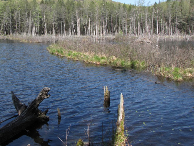


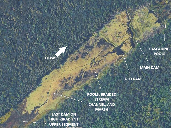
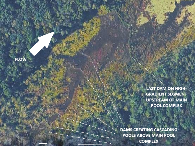


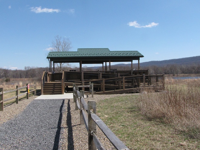


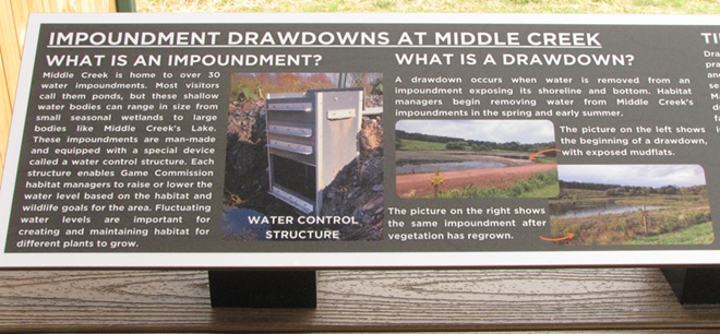


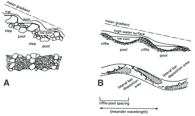


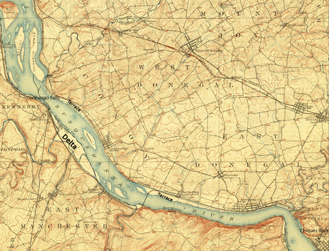


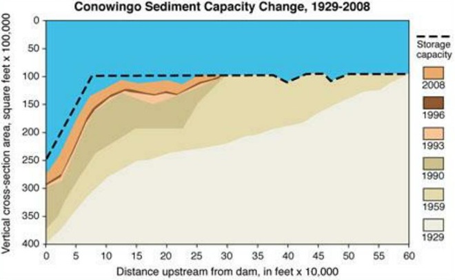


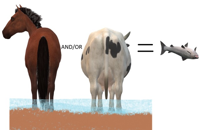


 Radiation")


 Watershed")