It all started rather innocently as a typically cold early January with sheets of ice covering the river and with soils on the lands in the remainder of the lower Susquehanna watershed frozen solid. Then came the “Blizzard of ’96”, blanketing much of the valley with between 20 and 30 inches of wind-driven snow.
Snowfall totals for the “Blizzard of ’96”, January 6-8, 1996. (NOAA/National Weather Service image)
In affected areas of Pennsylvania, Governor Tom Ridge closed all state roads for the duration of the snowfall event. Many would remain closed for much of the following week as drifting hampered exhaustive efforts to get impassable routes open.
In congested, high-density neighborhoods, cars remained buried for lack of anywhere to go with the snow. (Vintage 35 mm image)In more suburban areas, it was often a day-long chore to excavate a path to the street. (Vintage 35 mm image)
Just as the recovery entered its second week, a change in the weather pattern took hold as milder air and spring-like rains hastened the melt. Clogged by snow often several feet in depth, storm sewer inlets and other drainage features failed to collect the runoff. Street and urban flooding became widespread. Some buildings, particular those with large flat roofs, experienced structural damage due to any remaining snow soaking up the additional weight of the rain. As local creeks swelled to stain snowy meadows brown, attention shifted to the icy river.
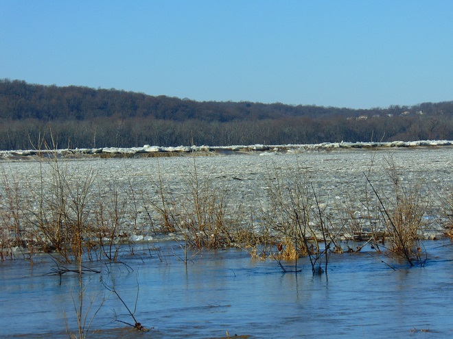
On the Susquehanna, rising waters started moving ice into accumulating piles of car-sized chunks behind dams and at choke points along the river’s course. During warmer weather, stream gauges provide a depth of water reference known as a stage (measured in feet) that corresponds to a rate of flow passing the gauge site (measured in cubic feet per second). On occasions when ice and debris block river channels during winter, these readings can fluctuate wildly and the relationship between stage and flow can become dubious. When the water is running ice-free at Harrisburg for example, a gauge reading of about 11.1 feet is indicated when the river flow rate is approximately 162,000 cubic feet per second. But due to its impact on the capability of the river channels to pass water, the presence of slow-moving and jammed ice can cause rapid and sometimes unpredictable variations in gauge readings, even when the flow rate remains steady. Impaired by an ice jam at the gauging station or just downriver, a flow of 162,000 cubic feet per second could lead to a stage measurement significantly higher than 11.1 feet, and the area of adjacent floodplain inundated by rising waters will increase to a corresponding degree. Conversely, a jam upstream of the gauging station could cause the reading to drop below 11.1 feet—at least temporarily—then look out, a dangerous surge could be forthcoming!
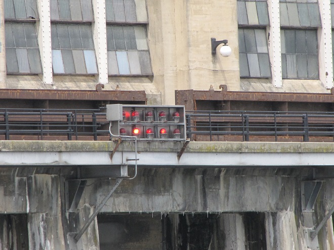
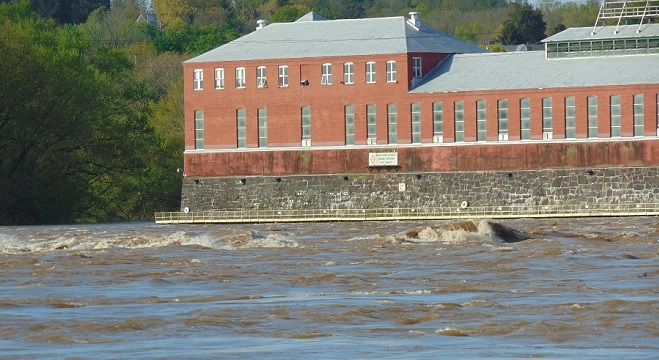
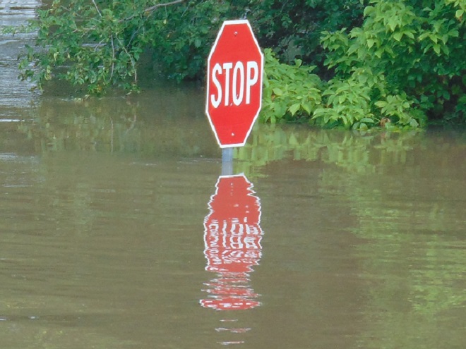
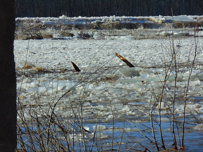
At Harrisburg, the ice jam behind the Dock Street Dam in January, 1996, caused devastating flooding in the city’s Shipoke neighborhood, on City Island, and in low-lying areas along the river’s west shore.
Just upriver from the Dock Street Dam at Harrisburg, the Susquehanna at the United States Geological Survey gauging station on the east side of City Island crested at 25.08 feet on January 20, 1996. As the rising waters finally began heaving the jammed ice up and over the dam, the scouring energy of the departing glacier-like mounds would carry away two spans of the truss-construction Walnut Street Bridge on the west side of the island, and eventually collapse a third. After receding during the remainder of the day and through the night, yet another aggregation of chunked ice would cause the river to crest again on January 21st, this time at 24.66 feet. Under free-flowing conditions, these readings would correspond to a river flow of just under 600,000 cubic feet per second; that’s more than 250 million gallons per minute!
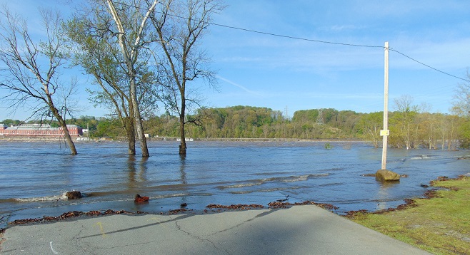
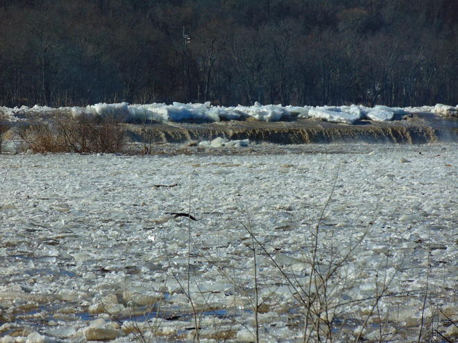
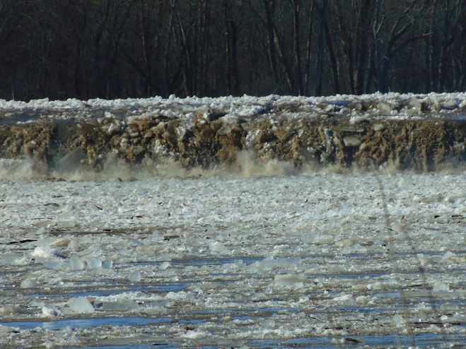
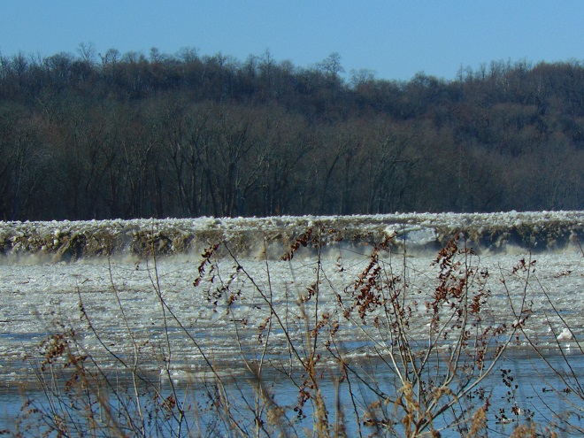
Downriver at Conewago Falls, ice jams behind the York Haven Dam and at several choke points within the riverine archipelago that extends from Haldeman Island to Haldeman Riffles in Lancaster County would be relieved as the river crested there during the afternoon of January 21st. The following photograph accurately relates the scene, minus the stench of mammalian feces and petroleum emanating from the polluted water of course.
Our friends (L to R) Rick Morton, Bob Zeager, Dan Seitz and his daughter Sierra witness the ice-choked Susquehanna River cresting below Conewago Falls on January 21, 1996. Bob awoke the previous morning inside his mobile home (left rear) to discover he was rapidly being surrounded by fast-rising water. With the ice-covered road now submerged in over three feet of river, he had no hope of getting out with his van, so he started removing clothing and a few other essentials by canoe. Dan soon arrived to move a few of his things to higher ground and de-energize both properties. We did our best to lend a hand, then we all got out of the floodplain. A short time after we had departed, Rick arrived and became concerned when he saw Bob’s van, now in almost four feet of water alongside his home. Rick parked his conveyance, also a van, on a rise in the lowland terrain, then made his way back the old Pennsylvania Canal towpath to make sure Bob wasn’t stranded. After concluding that he had already evacuated, Rick returned via the towpath to his van. He then discovered that yet another surge of quickly rising water had inundated the ice-covered section of access road by which he had arrived, so he was forced to wade out, leaving his vehicle behind. A short time later, he reached us by telephone proclaiming, “I’m out!”, and filled us in on the details. As the flood receded, Rick was able to retrieve his van on January 22nd. Bob’s van was totally destroyed and both his and Dan’s mobile homes were left uninhabitable. Though by no means their first experience with river flooding, this event proved particularly costly and stressful for Bob and Dan…the effects life-altering. The moral of the story: floodplains are for flooding, not filling, not building, and certainly not dwelling. Floodplains happen to make outstanding wildlife preserves, and that’s what this water-purifying alluvial terrace wetland is today. (Vintage 35 mm image)
You may find this hard to believe, but during the colder months in the lower Susquehanna valley, gulls aren’t as numerous as they used to be. In the years since their heyday in the late twentieth century, many of these birds have chosen to congregate in other areas of the Mid-Atlantic region where the foods they crave are more readily available.
As you may have guessed, the population boom of the 1980s and 1990s was largely predicated on human activities. These four factors were particularly beneficial for wintering gulls…
Disposal of food-bearing waste in open landfills
High-intensity agriculture with disc plowing
Gizzard Shad population boom in nutrient-impaired river/Hydroelectric power generation
Fumbled Fast Food
Earthworms lifted to the soil’s surface by plowing attracted Ring-billed Gulls by the thousands to Susquehanna Valley farmlands during the late twentieth century. (Vintage 35 mm image)Filter-feeding Gizzard Shad populations thrive in nutrient-rich waters like the Susquehanna. Their rambunctious feeding style stirs up benthic sediment deposits to release more nutrients into the water column and promote the algal blooms that often lead to detrimental eutrophic conditions. Decades ago, hundreds and sometimes thousands of gulls gathered below the river’s hydroelectric dams to feed on the seemingly endless supply of small Gizzard Shad disoriented by their passage through the turbines during electric generation. (Vintage 35 mm image)
So what happened? Why are wintering gulls going elsewhere and no longer concentrating on the Susquehanna? Well, let’s look at what has changed with our four man-made factors…
A larger percentage of the lower Susquehanna basin’s household and food industry waste is now incinerated/Landfills practice “cover as you go” waste burial.
Implementation of “no-till” farming has practically eliminated availability of earthworms and other sub-surface foods for gulls.
The population explosion of invasive Asiatic Clams has reduced the Gizzard Shad’s relative abundance and biomass among filter feeders.
Hold on tight! Fast food has become too expensive to waste.
The non-native population of Asiatic Clams in the Susquehanna and most of its larger tributaries exploded during the last two decades of the twentieth century. Its present-day biomass in the river is exceeded by no other macroinvertebrate species. The share of plankton and other tiny foods that the Asiatic Clam harvests from the water column is no longer available to native filter-feeders including Gizzard Shad. Hence, Gizzard Shad biomass has been reduced and far fewer are available to attract amazingly enormous flocks of hungry gulls to hydroelectric dams. (Vintage 35 mm image)
GULLS THIS WINTER
Despite larid abundance on the lower Susquehanna not being the spectacle it was during the man-made boom days, an observer can still find a variety of medium and large-sized gulls wintering in the region. We ventured out to catch a glimpse of some of the species being seen both within the watershed and very nearby.
By far, most of the gulls you’ll encounter in the Lower Susquehanna River Watershed right now are Ring-billed Gulls. Some of them still drop by at the business end of the drive-thru lane looking for a lost order of fries and maybe a cheeseburger in paradise.First-winter (left), second-winter (center), and adult Ring-billed Gulls on the Susquehanna.Nearly every flock of gulls found in our area right now is composed exclusively of Ring-billed Gulls. The trick to finding other species, particularly rarities, is to look for slightly larger birds mixed among them, particularly American Herring Gulls like the first-winter (back row left) and third-winter (back row right) birds seen here. Herring and other species of similar-sized gulls seem to prefer each other’s company while on the wintering grounds.Five American Herring Gulls with smaller Ring-billed Gulls. The bird to the upper left and the bird hunkered down to its right are adult American Herring Gulls, the three brownish birds are in their first winter.Non-adult American Herring Gulls in flight. Always look for birds with all-pale wing tips when encountering herring gulls in flight.Midway in size between the Ring-billed Gulls in the foreground and the first-winter American Herring Gulls in the upper left and middle right of this image is a Lesser Black-backed Gull (dark-mantled bird resting at center). The similar-sized bird in the water behind it is a first-winter Iceland Gull (Larus glaucoides), a rare visitor from the arctic.Another look at the first-winter Iceland Gull from the previous image. Did you notice the all-white primary feathers and compare them to the dark wing tips on the Ring-billed Gulls seen here in its company?The conspicuously pale wings of the first-winter Iceland Gull, seen here bathing in the presence of two first-winter American Herring Gulls.Both this first-winter Iceland Gull and the bird from the previous three images are currently being seen just east of the Susquehanna watershed at Blue Marsh Lake in Berks County, Pennsylvania. Additional Iceland Gulls are currently being reported in Maryland on the Susquehanna at Conowingo Dam; on upper Chesapeake Bay in Baltimore County, Maryland; and in southeastern-most Bucks County, near Tullytown, Pennsylvania, at a busy landfill site that attracts tens of thousands of gulls each winter. Double-digit numbers of Iceland Gulls have been reported at this latter site during recent weeks.Lesser Black-backed Gulls like this one observed at Blue Marsh Lake are uncommon in the Lower Susquehanna River Watershed. They are progressively more likely as you travel east toward the aforementioned Bucks County landfills where hundreds of these birds make up a core Atlantic seaboard population.Great Black-backed Gulls are the most frequently encountered large gull on the Susquehanna. They’re easily identified by their enormous size and, as adults, their dark mantle.Rivaling the Great Black-backed Gull in size is the Glaucous Gull (Larus hyperboreus), another rare arctic visitor with pale wing tips. There are numerous reports of these unusual winter visitors from sites on Delaware Bay north to the Tullytown landfills on Delaware River where half a dozen or more have been occurring. Seen near the mouth of the Susquehanna on Chesapeake Bay at North East, Maryland, has been a first-winter bird similar to this one that we photographed at Blue Marsh Lake in Berks County, Pennsylvania.
For us, seeing a Glaucous Gull brought back memories of the last time we saw the species. It was forty-five years ago on New Year’s Day 1981 that we discovered two first-winter birds feeding on Gizzard Shad in open water on an otherwise ice-choked Susquehanna below the York Haven Dam powerhouse at Conewago Falls. Hey Doc Robert, do you remember that day?
As the Flowering Dogwoods remind us, it’s time for adult sea-run shad and other fishes to ascend the Susquehanna to spawn. So yep, we’re off to Fisherman’s Park on the river’s west shoreline below Conowingo Dam in Harford County, Maryland, to check it out.
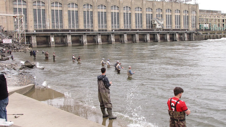
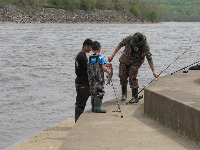
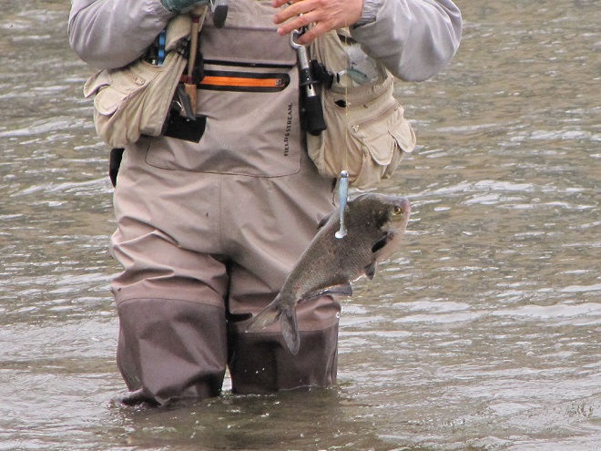
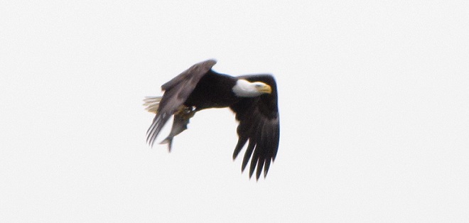
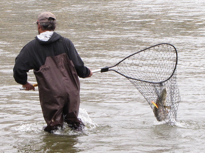
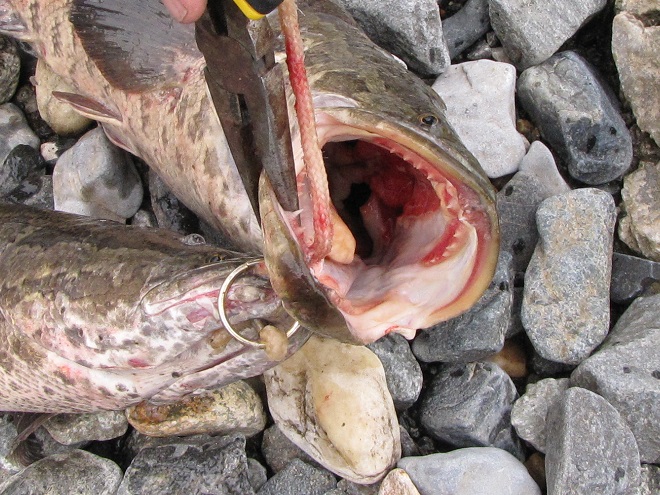
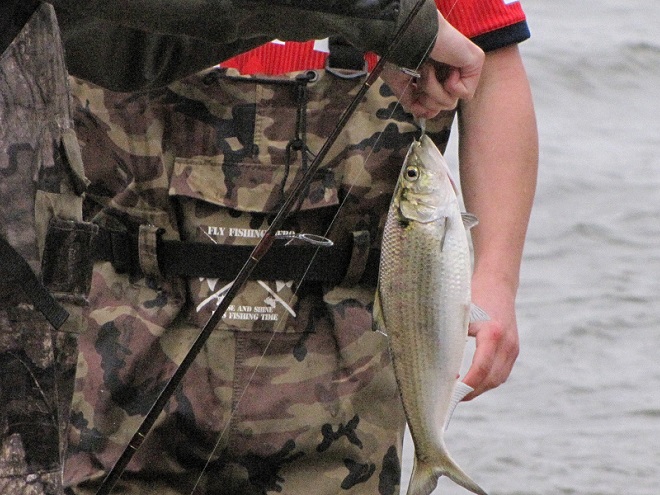
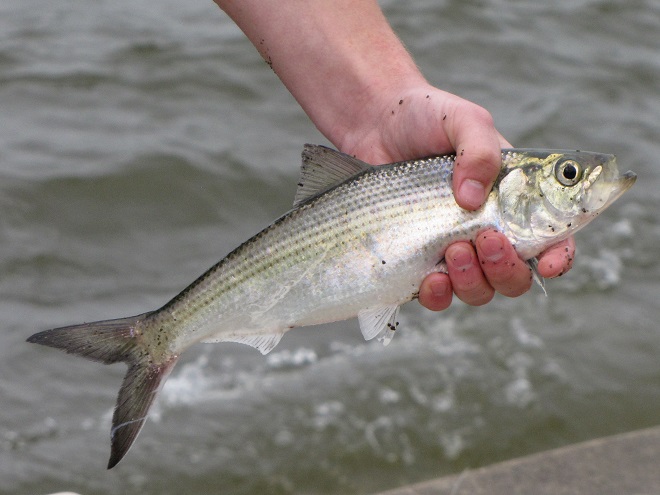
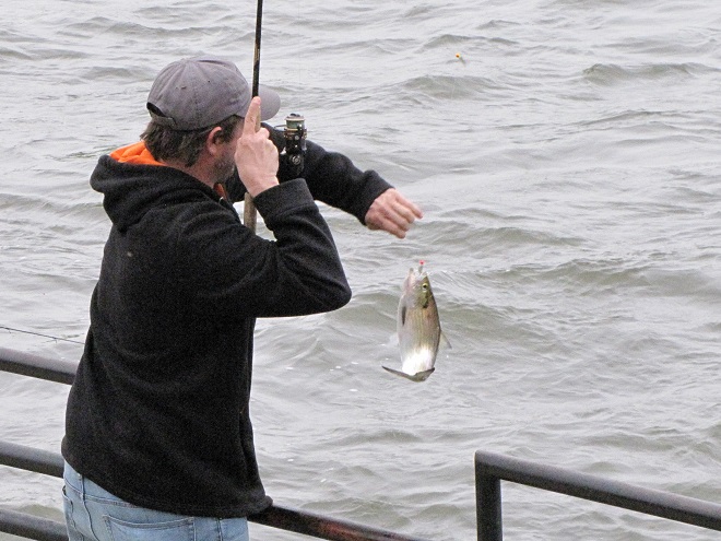
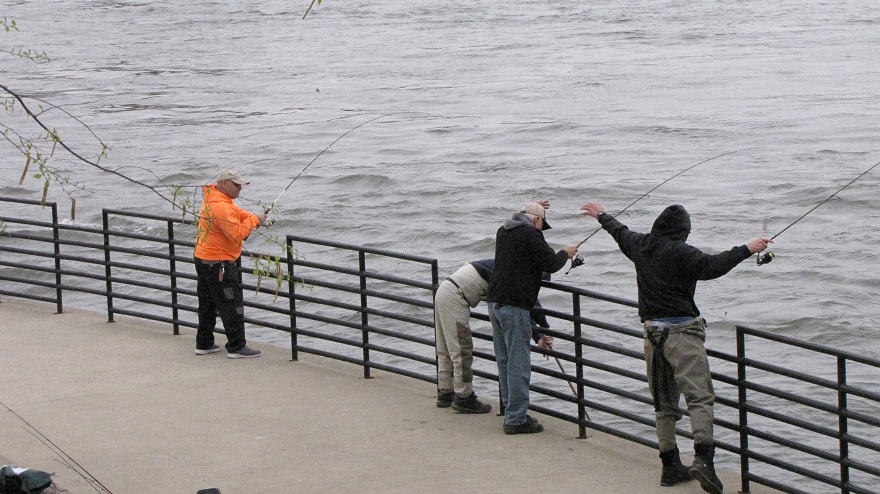
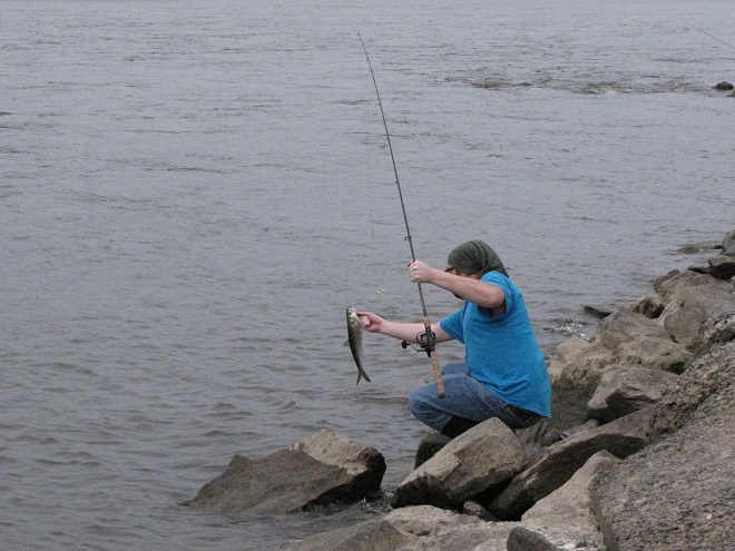
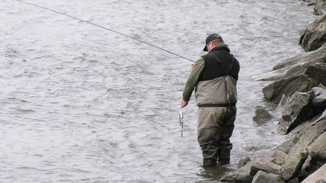
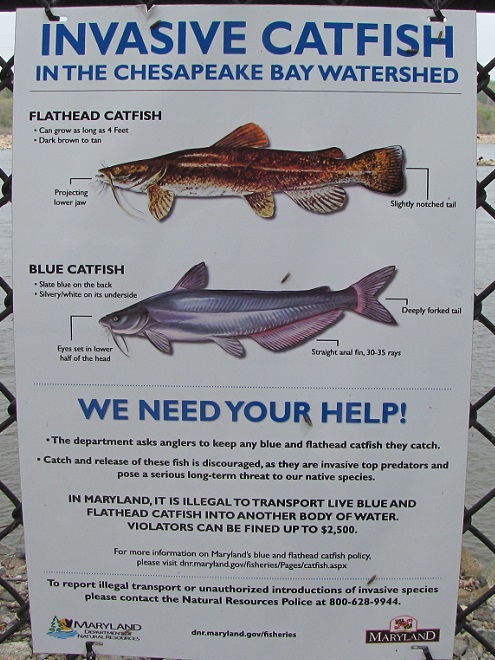
Anglers were in the water and seeing action as we arrived below Conowingo Dam’s powerhouse at Fisherman’s Park. The east lift, which was constructed during the 1990s to raise American Shad and other migratory fish over the dam during their spring spawning runs, sits idle at the impoundment end of the wing wall in the distance.The entrance to the idle east fish lift at Conowingo Dam.Within minutes, we watched one of the culprits responsible for the lift’s shutdown being reeled in. The invasive population of introduced Northern Snakeheads continues to thrive in the waters of the Susquehanna and its tributaries below the dam. To prevent it from expanding its range to upriver sections of the watershed, all American Shad are being manually separated from among the snakeheads and other fish species deposited into sorting tanks using the west lift near the powerhouse.One of several specialized transport vehicles returns from a “shad run” to the waters of the Susquehanna above York Haven Dam at Conewago Falls after delivering and releasing American Shad sorted from among the fish collected at Conowingo’s west lift earlier in the day.American Shad began their run up the Susquehanna as water temperatures reached 60 degrees Fahrenheit…just about the time the Flowering Dogwoods started to bloom within the river’s riparian woodlands. Later this month, spawning activity peaks when the water warms to about 65 degrees. Earlier in the season, when the water reached about 55 degrees, another anadromous species, the Hickory Shad (seen here), began their spring spawning run from sea to freshwater rivers and streams.While American Shad are seldom caught on hook and line, Hickory Shad are a popular catch-and-release target. Though they will energetically strike baits like the small shad dart seen here, Hickory Shad are very cautious while ascending the river; they very rarely enter the fish lifts to join the dozens of other species that readily accept their use. With water temperatures now in the sixties, an angler is seen here bringing in what may be among the last of this season’s Hickory Shad. Their spawning run is presently drawing to a close for the year.The most commonly caught herring at Fisherman’s Park is the Gizzard Shad. This plankton feeder seldom takes bait; it is instead foul-hooked. Though not a sea-run species, Gizzard Shad by the tens of thousands leave open waters to seek shallower flowing riffles and pools to spawn.Unlike the other herring occurring in the Susquehanna, the Gizzard Shad has a blunt, snub-nosed appearance to the snout. The mouth is small and often unnoticeable.The Gizzard Shad is the only species of Susquehanna herring that can legally be harvested. All others are sea-run migrants in varying degrees of population peril and must be returned to the water without delay.Note the elongated last ray on the dorsal fin of this foul-hooked Gizzard Shad. It’s a not-often-visible but nevertheless tell-tale field mark.Humans aren’t the only creatures attracted by the fish migration on the lower Susquehanna. This is just one of hundreds of Double-crested Cormorants we watched during our visit.Hungry cormorants gather along the base of the dam where ascending fish congregate and become further disoriented by water turbulence.Fishing efforts here can bring great success to these accomplished piscivores.Latching onto an oversize Gizzard Shad can make you very popular with your peers.So popular that you may never have the opportunity to eat your lunch.Take it from this old bird: you’ve gotta swallow ’em fast, head first, tail and all.A Bald Eagle hauls off a Gizzard Shad.An Osprey saw this Gizzard Shad swimming close enough to the water’s surface to dive in and snag it with its talons.And yet another successful Bald Eagle calls out to its mate as it approaches its nest and hungry young.An angler releases a small Striped Bass caught on a shad dart while fishing for Hickory Shad. To reduce pressure on their populations during the spring spawning run, the “Striper” harvest is presently closed. The fishing season resumes later this month in some areas, in June within others. On the Susquehanna Flats and other Chesapeake Bay waters, Striped Bass are also known as “Rockfish”.This angler is reeling in a big one.A nice Channel Catfish weighed in at about six pounds and was released.This angler brought in yet another interesting catch.The White Perch (Morone americana) is a bay species that ascends the Chesapeake’s tributaries to spawn during the spring. On the lower Susquehanna, numbers of this relative of the Striped Bass are falling, very possibly due to depredation by invasive snakeheads, Blue Catfish, and Flathead Catfish.A Double-crested Cormorant does its duty and snatches up an invasive Blue Catfish. Very large Blue Catfish exceeding 24 inches in length are becoming increasingly plentiful on the upper Chesapeake and its tributaries resulting in a significant negative impact on the aquatic ecosystems there. Like the Northern Snakehead and Flathead Catfish, these invasive species are very palatable and anglers are encouraged to catch and keep as many as they like.Maryland DNR sign at Fisherman’s Park.What can we do about the plague of Northern Snakeheads (Channa argus) in the Susquehanna? Well, let’s start by answering a question with a question…Why deplete ocean stocks when you can follow this angler’s example and harvest excellent fillets while helping to control an invasive species at the same time? And no, you don’t have to call them “Chesapeake Channa” if you don’t want to. Though you will make us laugh if you start calling them “Susquehanna Channa” or just “Susquechanna” from time to time.
As week-old snow and ice slowly disappears from the Lower Susquehanna River Watershed landscape, we ventured out to see what might be lurking in the dense clouds of fog that for more than two days now have accompanied a mid-winter warm spell.
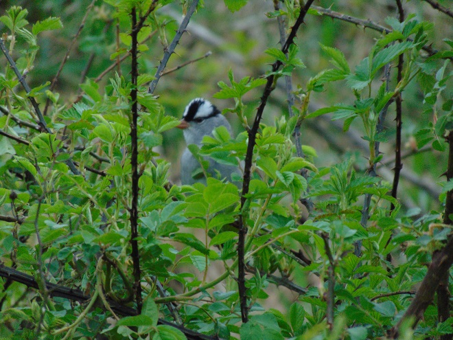
After freezing to a slushy consistency earlier this week, the Susquehanna is already beginning to thaw. Below the York Haven Dam at Conewago Falls, the water is open and ice-free.On frozen man-made lakes and ponds, geese and ducks like these Mallards and American Wigeon are presently concentrated around small pockets of open water.During the past ten days, American Robin numbers have exploded throughout the lower Susquehanna valley. The majority of these birds may be a mix of both those coming south to escape the late onset of wintry conditions to our north and those inching north into our region as early spring migrants.The January thaw has melted the snow from lawns and fields to provide thousands of visiting robins with a chance to forage for earthworms.A visit by this young Cooper’s Hawk to the susquehannnawildlife.net headquarters garden sent songbirds scrambling……but did nothing to unnerve our resident Eastern Gray Squirrels,……which promptly went into tail-waving mode to advertise their presence.But earlier in the week, when heavy snow cover in the rural areas surrounding our urbanized neighborhood made it difficult for rodent-eating raptors to find food, we received brief visits from both a Red-tailed Hawk……and this young Red-shouldered Hawk, an uncommon bird of prey most often found in wet woods and other lowlands.To escape notice during visits by these larger raptors, our squirrels remained motionless and commenced performance of their best bump-on-a-log impressions.Unimpressed, each of our visiting buteos remained for just a few minutes before moving on in search of more favorable hunting grounds and prey.As snow melted and exposed bare ground in fields of early successional growth, we encountered……a flock of White-crowned Sparrows, most in first-winter plumage……and at least a dozen American Tree Sparrows. During the twentieth century, these handsome songbirds were regular winter visitors to the lower Susquehanna region. During recent decades, they’ve become increasingly more difficult to find. Currently, moderate numbers appear to be arriving to escape harsher weather to our north.What could be more appropriate on a foggy, gray evening than finding a “gray ghost” (adult male Northern Harrier) patrolling the fields in search of mice and voles.
If scenes of a January thaw begin to awaken your hopes and aspirations for all things spring, then you’ll appreciate this pair of closing photographs…
The maroon-red flower buds of Silver Maples are beginning to swell. And woodpeckers including Pileated Woodpeckers are beginning to drum, a timber-pounding behavior they use to establish breeding territories in habitats with suitable sites for cavity nesting.In wet soil surrounding spring seeps and streams, Skunk Cabbage is rising through the leaf litter to herald the coming of a new season. Spring must surely be just around the corner.
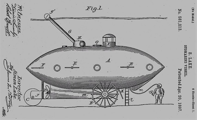
First there was the Nautilus. Then there was the Seaview. And who can forget the Yellow Submarine? Well, now there’s the S. S. Haldeman, and today we celebrated her shakedown cruise and maiden voyage. The Haldeman is powered by spent fuel that first saw light of day near Conewago Falls at a dismantled site that presently amounts to nothing more than an electrical substation. Though antique in appearance, the vessel discharges few emissions, provided there aren’t any burps or hiccups while underway. So, climb aboard as we take a cruise up the Susquehanna at periscope depth to have a quick look around!
Brunner Island as seen from the east channel.Close-in approach to emergent Water Willow growing on an alluvial Island.The approach to York Haven Dam and Conewago Falls from the west channel.A pair of Powdered Dancers on a midriver log.
Watertight and working fine. Let’s flood the tanks and have a peek at the benthos. Dive, all dive!
American Eelgrass, also known as Tapegrass, looks to be growing well in the channels. Historically, vast mats of this plant were the primary food source for the thousands of Canvasback ducks that once visited the lower Susquehanna each autumn.As is Water Stargrass (Heteranthera dubia). When mature, both of these native plants provide excellent cover for young fish. Note the abundance of shells from deceased Asiatic Clams (Corbicula fluminea) covering the substrate.A three-tailed mayfly (Ephemeroptera) nymph and a several exoskeletons cling to the downstream side of a rock.This hollowed-out stick may be a portable protective shelter belonging to a Comb-lipped Casemaker Caddisfly larva (Calamoceratidae). The larva itself appears to be extending from the end of the “case” in the upper right of the image. Heteroplectron americanum, a species known for such behavior, is a possibility. In the Susquehanna and its tributaries, the Rusty Crayfish (Faxonius rusticus) is an introduced invasive species. It has little difficulty displacing native species due to its size and aggressiveness.A Rusty Crayfish.Summers with conditions that promote eelgrass and stargrass growth tend to be big years for Virginian River Horn Snails (Elimia virginica). 2022 appears to be one of those years. They’re abundant and they’re everywhere on the rocks and gravel substrate in midriver. Feeding almost incessantly on algae and detritus, these snails are an essential component of the riverine ecosystem, breaking down organic matter for final decomposition by bacteria and fungi.Bits of debris suspended in the flowing water streak by this Virginian River Horn Snail. The spire-shaped shell is a streamlining adaptation for maneuvering and holding fast in the strong current.A young Virginian River Horn Snail following a mature adult. Note the green algae growing among the decaying plant and animal remains that blanket the river bottom.Two of a population that may presently include millions of Virginian River Horn Snails living downstream of Conewago Falls.Virginian River Horn Snails with Lesser Mystery Snails (Campeloma decisum), another native species commonly encountered at Conewago Falls and in surrounding waters.A River Snail (Leptoxis carinata), also known as a Crested Mudalia, hitching a ride on a Virginian River Horn Snail. The two species are frequently found together.A River Snail cleaning the shell of a native freshwater Unionidae mussel, Lampsilis cariosa, commonly called the Yellow Lampmussel or Carried Lampmussel. Because of their general decline in abundance and range, all Unionidae mussels are protected in Pennsylvania.The Banded Darter (Etheostoma zonale) is a member of the perch family (Percidae).A Smallmouth Bass in strong current.Along the edge of an alluvial island at midriver, Cyprinella (Spotfin or Satinfin) Shiners gather in the cover of an emergent stand of Water Willow. The closely related Spotfin Shiner (Cyprinella spiloptera) and Satinfin Shiner (Cyprinella analostanus) are nearly impossible to differentiate in the field.A breeding condition male Cyprinella (Spotfin or Satinfin) Shiner.A juvenile Channel Catfish.
We’re finding that a sonar “pinger” isn’t very useful while running in shallow water. Instead, we should consider bringing along a set of Pings—for the more than a dozen golf balls seen on the river bottom. It appears they’ve been here for a while, having rolled in from the links upstream during the floods. Interestingly, several aquatic species were making use of them.
River Snail cleaning a golf ball.A golf ball used as an anchor point for silk cases woven by Net-spinning Caddisfly (Hydropsychidae) larvae to snare food from the water column.A Creeping Ancylid (Ferrissia species), a tiny gastropod also known as a Coolie Hat Snail, River Limpet, or Brook Freshwater Limpet, inhabits the dimple on a “Top Flight”.A closeup view of the Creeping Ancylid. The shell sits atop the snail’s body like a helmet.We now know why your golf balls always end up in the drink, it’s where they go to have their young.
Well, it looks like the skipper’s tired and grumpy, so that’s all for now. Until next time, bon voyage!
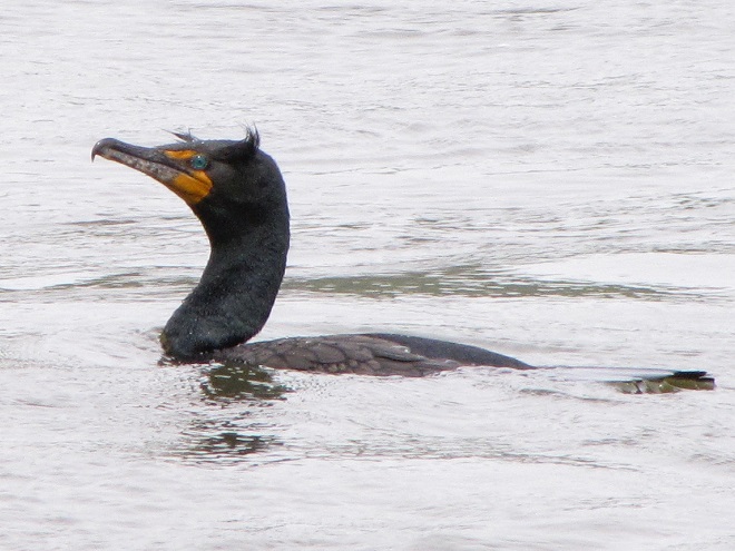
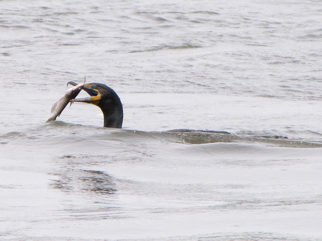
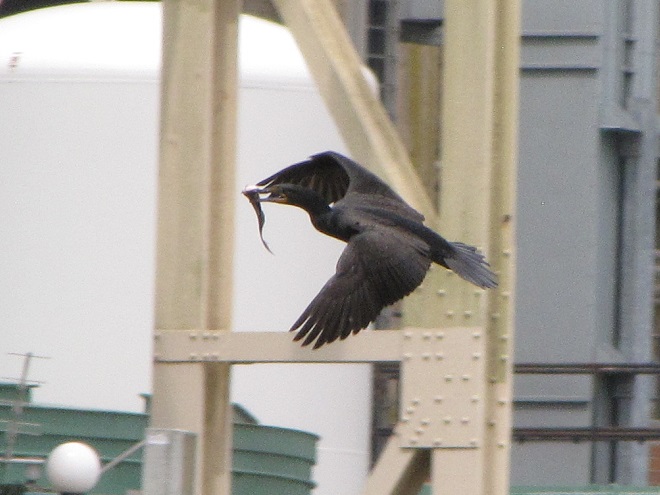
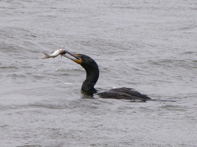
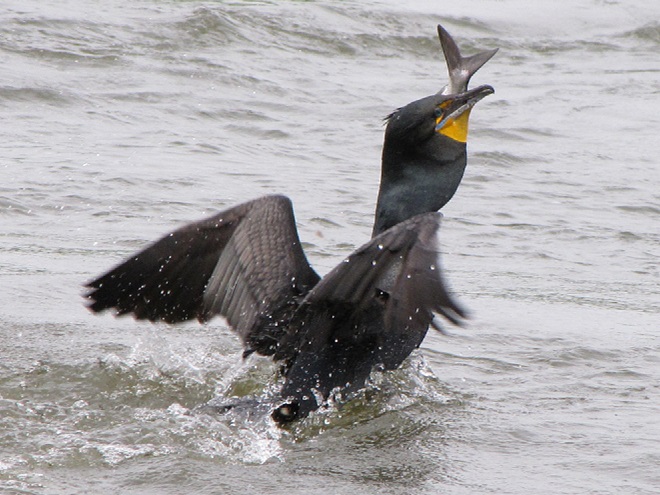
Meet the Double-crested Cormorant, a strangely handsome bird with a special talent for catching fish. You see, cormorants are superb swimmers when under water—using their webbed feet to propel and maneuver themselves with exceptional speed in pursuit of prey.
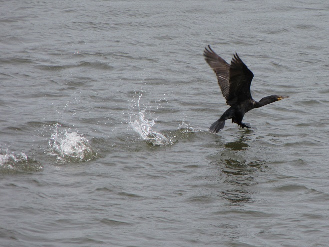
Like many species of birds that dive for their food, Double-crested Cormorants run across the surface of the water to gain speed for a takeoff. Smaller wings may make it more difficult to get airborne, but when folded, they provide improved streamlining for submerged swimming.
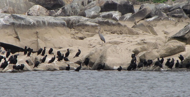
Double-crested Cormorants, hundreds of them, are presently gathered along with several other species of piscivorous (fish-eating) birds on the lower Susquehanna River below Conowingo Dam near Rising Sun, Maryland. Fish are coming up the river and these birds are taking advantage of their concentrations on the downstream side of the impoundment to provide food to fuel their migration or, in some cases, to feed their young.
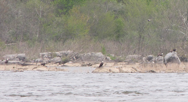
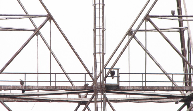
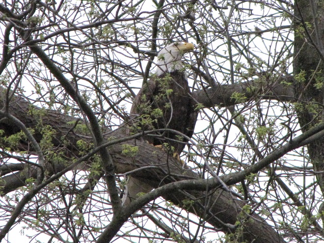
Double-crested Cormorants, mostly adult birds migrating toward breeding grounds to the north, are gathered on the rocks on the east side of the river channel below Conowingo Dam. A Great Blue Heron from a nearby rookery can be seen at the center of the image.Bald Eagles normally gather in large numbers at Conowingo Dam in the late fall and early winter. Presently there are more than 50 there, and the majority of them are breeding age adults. Presumably they are still on their way north to nest. Meanwhile, local pairs are already feeding young, so it seems these transient birds are running a bit late. Many of them can be seen on the rocks along the east side of the river channel,……on the powerline trestles on the island below the dam……in the trees along the east shore,……and in the trees surrounding Fisherman’s Park on the west shore.
In addition to the birds, the movements of fish attract larger fish, and even larger fishermen.
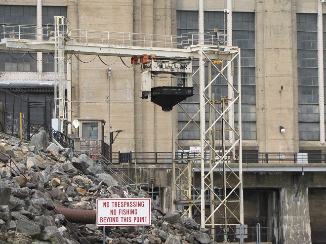
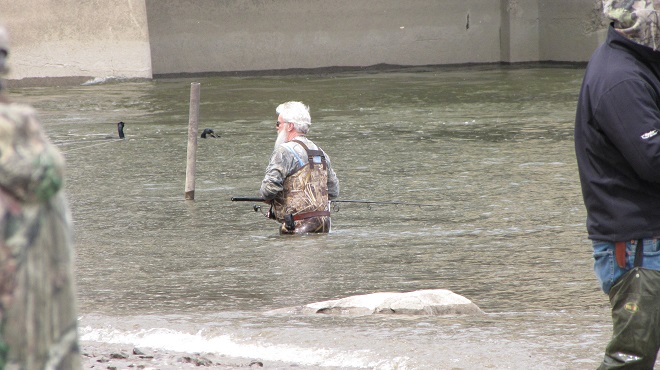
Anglers gather to fish the placid waters below the dam’s hydroelectric powerhouse . Only a few of the generating turbines are operating, so the flow through the dam is minimal.Some water is being released along the west shoreline to attract migratory river herring to the west fish lift for sorting and retention as breeding stock for a propagation program. The east lift, the passage that hoists American Shad (Alosa sapidissima) to a trough that allows them to swim over the top of the dam to waters upriver, will begin operating as soon as these larger migratory fish begin arriving.
The excitement starts when the sirens start to wail and the red lights begin flashing. Yes friends, it’s showtime.
Red lights and sirens are a warning that additional flow is about to be released from the dam. Boaters should anticipate rough water and persons in and along the river need to seek higher ground immediately.Gates are opened at mid-river to release a surge of water through the dam.The wake from the release quickly reaches the shoreline, raising the water level in moments.Experienced anglers know that the flow through the dam gets fish moving and can improve the catch significantly, especially in spring when many species are ascending the river.
Within minutes of the renewed flow, birds are catching fish.
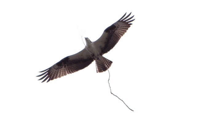
A Double-crested Cormorant with a young Channel Catfish (Ictalurus punctatus).A Double-crested Cormorant fleeing others trying to steal its Channel Catfish.Another Double-crested Cormorant eating a Channel Catfish. Did you realize that Channel Catfish were an introduced species in the Susquehanna River system?An Osprey with a stick, it’s too busy building a nest right now to fish.Great Blue Herons swallow their prey at the spot of capture, then fly back to the nest to regurgitate a sort of “minced congealed fish product” to their young.
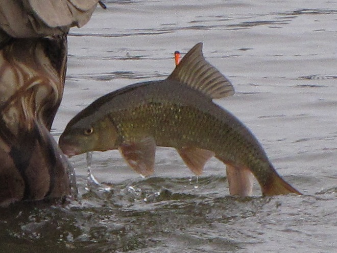
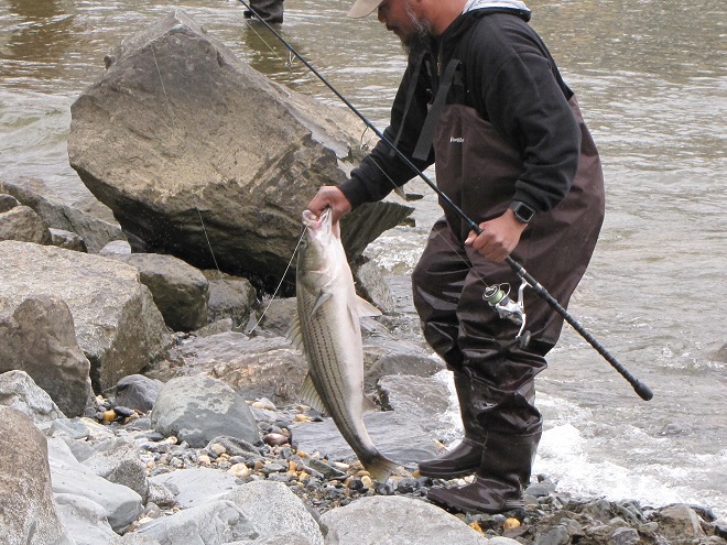
Then the anglers along the wave-washed shoreline began catching fish too.
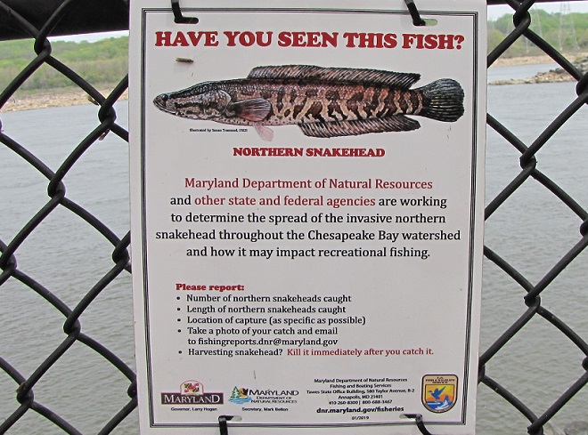
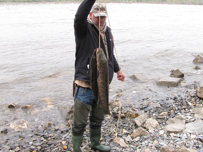
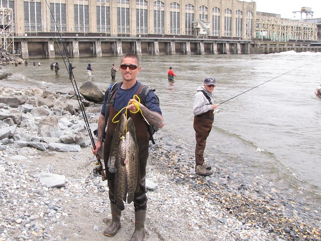
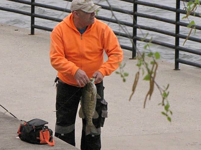
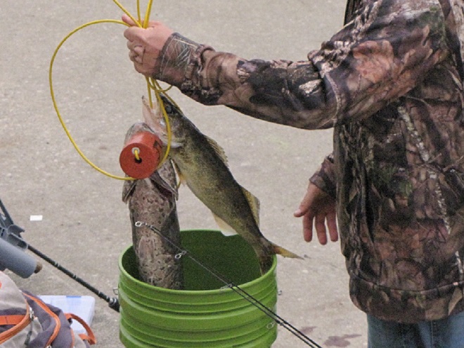
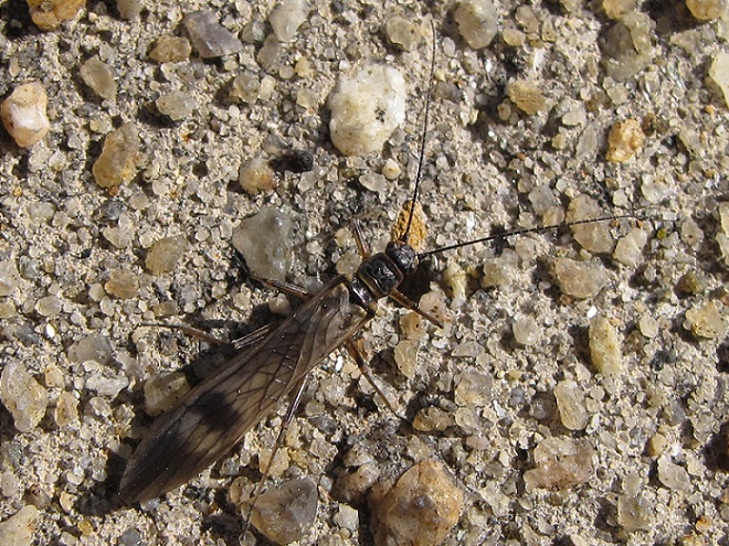
This young man led off a flurry of catches that would last for the remainder of the afternoon.Though Gizzard Shad are filter feeders that don’t readily take baits and lures, they are regularly foul-hooked and reeled in from the large schools that ascend the river in spring.Gizzard Shad are very abundant in the lower Susquehanna, providing year-round forage for many species of predatory animals including Bald Eagles.A Double-crested Cormorant swallowing a Gizzard Shad.This angler soon helped another fisherman by landing his large catch, a Northern Snakehead (Channa argus).The teeth of a Northern Snakehead are razor sharp. It is an aggressive non-native invasive species currently overtaking much of the Lower Susquehanna River Watershed. Anglers are encouraged to fish for them, catch them, keep them, and kill them at the site of capture. Never transport a live Northern Snakehead anywhere at any time. It is illegal in both Maryland and Pennsylvania to possess a live snakehead. Northern Snakehead advisory sign posted at Exelon Energy’s Conowingo Fishermen’s Park.A stringer of Northern Snakeheads. This species was imported from Asia as a food fish, so it has excellent culinary possibilities. It’s better suited for a broiler or frying pan than a river or stream.Another stringer of Northern Snakeheads. It’s pretty safe to say that they have quickly become one of the most abundant predatory fish in the river. Their impact on native species won’t be good, so catch and eat as many as you can. Remember, snakeheads swim better in butter and garlic than in waters with native fish.This foul-hooked Shorthead Redhorse (Moxostoma macrolepidotum), a native species of sucker, was promptly released.Striped Bass are anadromous fish that leave the sea in spring to spawn in fresh water. They ascend the Susquehanna in small numbers, relying upon the operation of the fish passages at the Conowingo, Holtwood, Safe Harbor, and York Haven Dams to continue their journey upstream. During spring spawning, Striped Bass in the Susquehanna River and on the Susquehanna Flats portion of the upper Chesapeake Bay are not in season and may not be targeted, even for catch-and-release. This accidental catch was immediately turned loose.After removal from the hook, this hefty Smallmouth Bass was returned to the river. Many anglers are surprised to learn that Smallmouth Bass are not native to the Susquehanna basin.This angler’s creel contains a Northern Snakehead (left) and a Walleye (right). Did you know that the Walleye (Sander vitreus) is an introduced species in the Susquehanna watershed?By late afternoon, anglers using shad darts began hooking into migrating Hickory Shad (Alosa mediocris), a catch-and-release species in Maryland.Hickory Shad are recognized by their lengthy lower jaw. They are anadromous herring that leave the sea to spawn in freshwater streams. Hickory Shad ascend the Susquehanna as far as Conowingo Dam each year, but shy away from the fish lifts. Downriver from the dam, they do ascend Deer Creek along the river’s west shore and Octoraro Creek on the east side. In Pennsylvania, the Hickory Shad is an endangered species.A Hickory Shad angled on a dual shad dart rig. During the spring spawning run, they feed mostly on small fish, and are the most likely of the Susquehanna’s herring to take the hook.Simultaneous hook-ups became common after fours hours worth of release water from the dam worked its way toward the mouth of the river and got the schools moving. Water temperatures in the mid-to-upper-fifties trigger the ascent of Hickory Shad. On the Susquehanna, those temperatures were slow to materialize in the spring of 2021, so the Hickory Shad migration is a bit late.Catch-and-release fishing for Hickory Shad appears to be in full swing not only at the dam, but along the downstream shoreline to at least the mouth of Deer Creek at Susquehanna State Park too.Many Hickory Shad could be seen feeding on some of the millions of caddisflies (Trichoptera) swarming on the river. These insects, along with earlier hatches of Winter Stoneflies (Taeniopterygidae), not only provide forage for many species of fish, but are a vital source of natural food for birds that migrate up the river in March and April each year. Swallows, Ring-billed Gulls, and Bonaparte’s Gulls are particularly fond of snatching them from the surface of the water.A Winter Stonefly (Taeniopterygidae) from an early-season hatch on the Susquehanna River at the Veteran’s Memorial Bridge at Columbia/Wrightsville, Pennsylvania. (March 3, 2021)Just below Conowingo Dam, a lone fly fisherman was doing a good job mimicking the late-April caddisfly hatch, successfully reeling in numerous surface-feeding Hickory Shad.You may have noticed the extraordinary number of introduced fish species listed in this account of a visit to Conowingo Dam. Sorry to say that there are two more: the Flathead Catfish (Pylodictis olivaris) and the Blue Catfish (Ictalurus furcatus). Like the Northern Snakehead, each has become a plentiful invasive species during recent years. Unlike the Northern Snakehead, these catfish are “native transplants”, species introduced from populations in the Mississippi River and Gulf Slope drainages of the United States. So if you visit the area, consider getting a fishing license and catching a few. Like the snakeheads, they too are quite palatable.
The arrival of migrating Hickory Shad heralds the start of a movement that will soon include White Perch, anadromous American Shad, and dozens of other fish species that swim upstream during the springtime. Do visit Fisherman’s Park at Conowingo Dam to see this spectacle before it’s gone. The fish and birds have no time to waste, they’ll soon be moving on.
To reach Exelon’s Conowingo Fisherman’s Park from Rising Sun, Maryland, follow U.S. Route 1 south across the Conowingo Dam, then turn left onto Shuresville Road, then make a sharp left onto Shureslanding Road. Drive down the hill to the parking area along the river. The park’s address is 2569 Shureslanding Road, Darlington, Maryland.
A water release schedule for the Conowingo Dam can be obtained by calling Exelon Energy’s Conowingo Generation Hotline at 888-457-4076. The recording is updated daily at 5 P.M. to provide information for the following day.
And remember, the park can get crowded during the weekends, so consider a weekday visit.
You need to get outside and go for a walk. You’ll be sorry if you don’t. It’s prime time to see wildlife in all its glory. The songs and colors of spring are upon us!
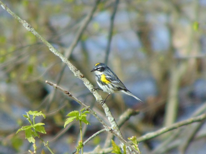
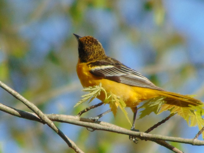
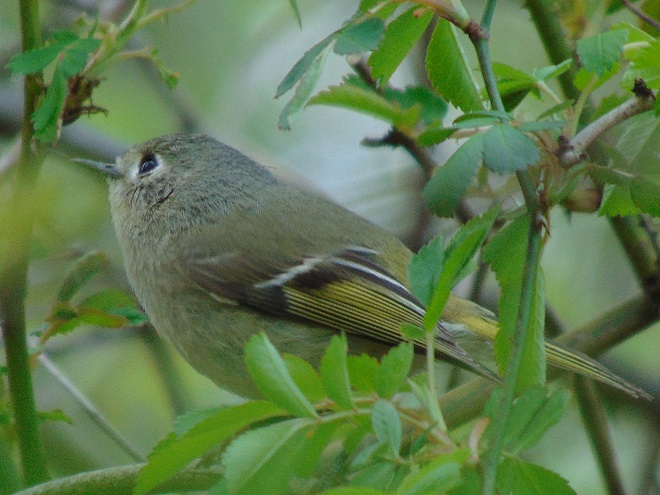
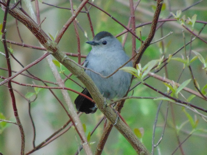
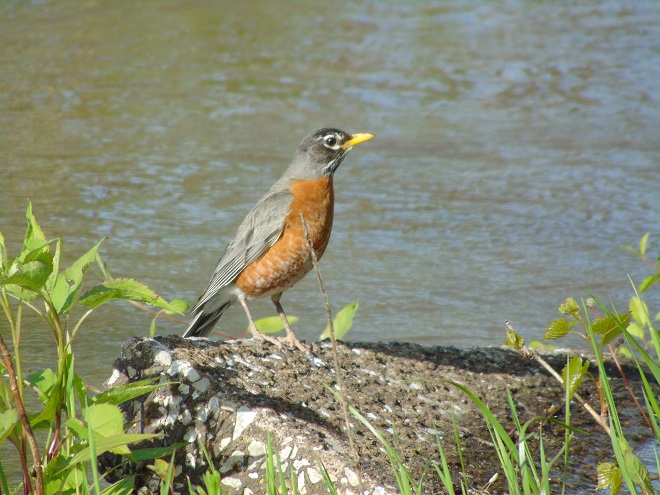
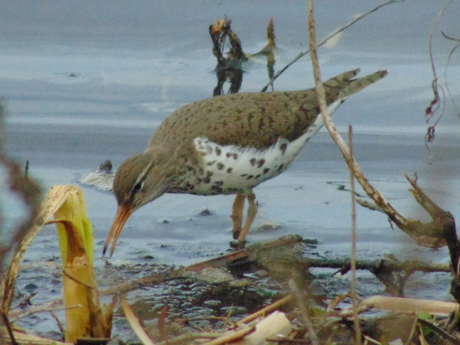
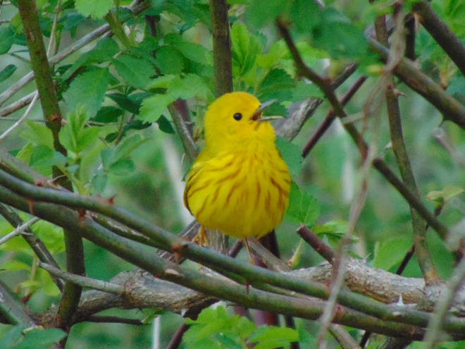
Flooding that resulted from mid-week rains is subsiding. The muddy torrents of Conewago Falls are seen here racing by the powerhouse at the York Haven Dam.Receding waters will soon leave the parking area at Falmouth and other access points along the river high and dry.Migrating Yellow-rumped Warblers are currently very common in the riparian woodlands near Conewago Falls. They and all the Neotropical warblers, thrushes, vireos, flycatchers are moving through the Susquehanna watershed right now.A Baltimore Oriole feeds in a riverside maple tree.Ruby-crowned Kinglets are migrating through the Susquehanna valley. These tiny birds may be encountered among the foliage of trees and shrubs as they feed upon insects .Gray Catbirds are arriving. Many will stay to nest in shrubby thickets and in suburban gardens.American Robins and other birds take advantage of rising flood waters to feed upon earthworms and other invertebrates that are forced to the soil’s surface along the inundated river shoreline.Spotted Sandpipers are a familiar sight as they feed along water’s edge.The Yellow Warbler (Setophaga petechia) is a Neotropical migrant that nests locally in wet shrubby thickets. Let your streamside vegetation grow and in a few years you just might have these “wild canaries” singing their chorus of “sweet-sweet-sweet-I’m-so-sweet” on your property.
If you’re not up to a walk and you just want to go for a slow drive, why not take a trip to Middle Creek Wildlife Management Area and visit the managed grasslands on the north side of the refuge. To those of us over fifty, it’s a reminder of how Susquehanna valley farmlands were before the advent of high-intensity agriculture. Take a look at the birds found there right now.
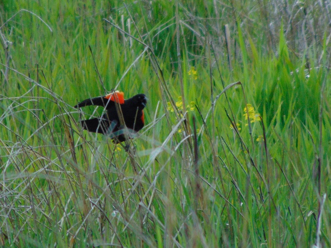
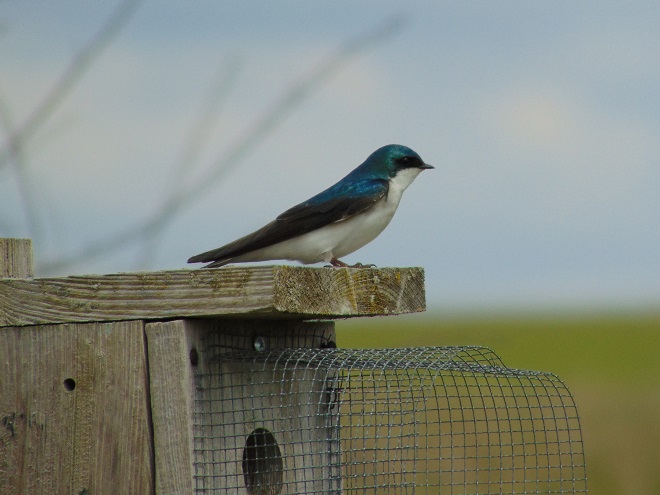
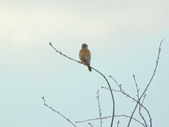
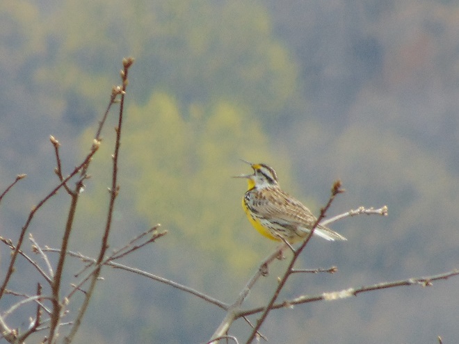
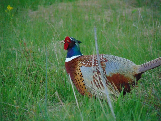
Red-winged Blackbirds commonly nest in cattail marshes, but are very fond of untreated hayfields, lightly-grazed pastures, and fallow ground too. These habitats are becoming increasingly rare in the lower Susquehanna region. Farmers have little choice, they either engage in intensive agriculture or go broke.Nest boxes are provided for Tree Swallows at the refuge.Numbers of American Kestrels have tumbled with the loss of grassy agricultural habitats that provide large insects and small rodents for them to feed upon.White-crowned Sparrows (Zonotrichia leucophrys) are a migrant and winter resident species that favors small clumps of shrubby cover in pastures and fallow land.When was the last time you saw an Eastern Meadowlark (Sturnella magna) singing “spring-of-the-year” in a pasture near your home?And yes, the grasslands at Middle Creek do support nesting Ring-necked Pheasants (Phasianus colcichus). If you stop for a while and listen, you’ll hear the calls of “kowk-kuk” and a whir of wings. Go check it out.
And remember, if you happen to own land and aren’t growing crops on it, put it to good use. Mow less, live more. Mow less, more lives.
It was a routine occurrence in many communities along tributaries of the lower Susquehanna River during the most recent two months. The rain falls like it’s never going to stop—inches an hour. Soon there is flash flooding along creeks and streams. Roads are quickly inundated. Inevitably, there are motorists caught in the rising waters and emergency crews are summoned to retrieve the victims. When the action settles, sets of saw horses are brought to the scene to barricade the road until waters recede. At certain flood-prone locations, these events are repeated time and again. The police, fire, and Emergency Medical Services crews seem to visit them during every torrential storm—rain, rescue, rinse, and repeat.
We treat our local streams and creeks like open sewers. Think about it. We don’t want rainwater accumulating on our properties. We pipe it away and grade the field, lawn, and pavement to roll it into the neighbor’s lot or into the street—or directly into the waterway. It drops upon us as pure water and we instantly pollute it. It’s a method of diluting all the junk we’ve spread out in its path since the last time it rained. A thunderstorm is the big flush. We don’t seem too concerned about the litter, fertilizer, pesticides, motor fluids, and other consumer waste it takes along with it. Out of sight, out of mind.
Failure to retain and infiltrate stormwater to recharge aquifers can later result in well failures and reduced base flow in streams. (Conoy Creek’s dry streambed in June, 2007)
Perhaps our lack of respect for streams and creeks is the source of our complete ignorance of the function of floodplains.
Floodplains are formed over time as hydraulic forces erode bedrock and soils surrounding a stream to create adequate space to pass flood waters. As floodplains mature they become large enough to reduce flood water velocity and erosion energy. They then function to retain, infiltrate, and evaporate the surplus water from flood events. Microorganisms, plants, and other life forms found in floodplain wetlands, forests, and grasslands purify the water and break down naturally-occurring organic matter. Floodplains are the shock-absorber between us and our waterways. And they’re our largest water treatment facilities.
Why is it then, that whenever a floodplain floods, we seem motivated to do something to fix this error of nature? Man can’t help himself. He has a compulsion to fill the floodplain with any contrivance he can come up with. We dump, pile, fill, pave, pour, form, and build, then build some more. At some point, someone notices a stream in the midst of our new creation. Now it’s polluted and whenever it storms, the darn thing floods into our stuff—worse than ever before. So the project is crowned by another round of dumping, forming, pouring, and building to channelize the stream. Done! Now let’s move all our stuff into our new habitable space.
Natural Floodplain- Over a period of hundreds or thousands of years, the stream (dark blue) has established a natural floodplain including wetlands and forest. In this example, buildings and infrastructure are located outside the zone inundated by high water (light blue) allowing the floodplain to function as an effective water-absorbing buffer.Impaired Floodplain- Here the natural floodplain has been filled for building (left) and paved for recreation area parking (right). The stream has been channelized. Flood water (light blue) displaced by these alterations is likely to inundate areas not previously impacted by similar events. Additionally, the interference with natural flow will create new erosion points that could seriously damage older infrastructure and properties.
The majority of the towns in the lower Susquehanna valley with streams passing through them have impaired floodplains. In many, the older sections of the town are built on filled floodplain. Some new subdivisions highlight streamside lawns as a sales feature—plenty of room for stockpiling your accoutrements of suburban life. And yes, some new homes are still being built in floodplains.
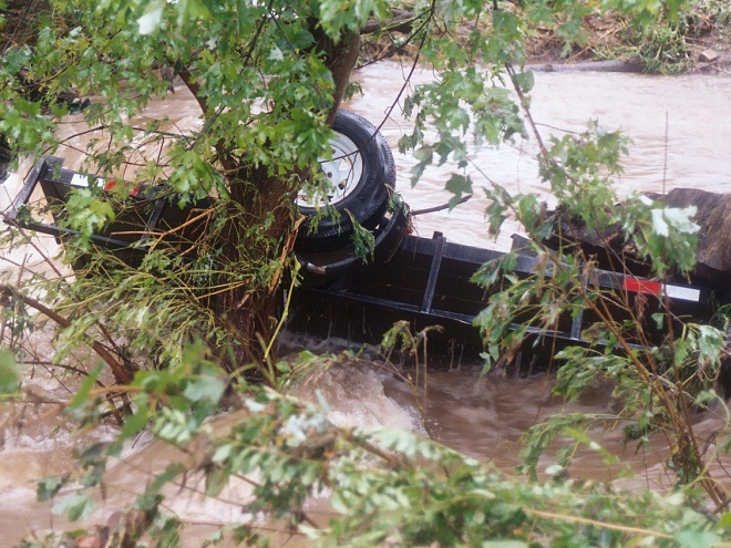
When high water comes, it drags tons of debris with it. The limbs, leaves, twigs, and trees are broken down by natural processes over time. Nature has mechanisms to quickly cope with these organics. Man’s consumer rubbish is another matter. As the plant material decays, the embedded man-made items, particularly metals, treated lumber, plastics, Styrofoam, and glass, become more evident as an ever-accumulating “garbage soil” in the natural floodplains downstream of these impaired areas. With each storm, some of this mess floats away again to move ever closer to Chesapeake Bay and the Atlantic. Are you following me? That’s our junk from the curb, lawn, highway, or parking lot bobbing around in the world’s oceans.
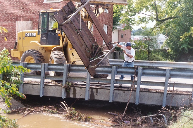
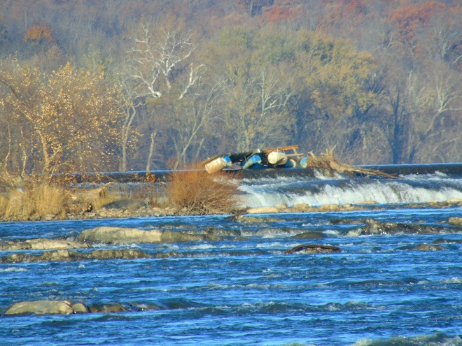
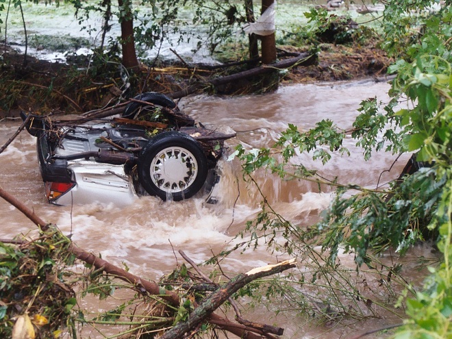
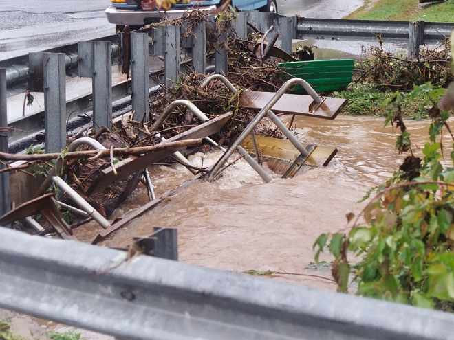
A shed, mobile home, or house can be inundated or swept away during a flood. Everything inside (household chemicals, gasoline, fuel oil, pesticides, insulation, all those plastics, etc.) instantly pollutes the water. Many communities that rely on the Susquehanna River for drinking water are immediately impacted, including Lancaster, PA and Baltimore, MD. This dumpster was swept away from a parking lot in a floodplain. It rolled in the current, chipping away at the bridge before spilling the rubbish into the muddy water. After the flood receded, the dumpster was found a mile downstream. Its contents are still out there somewhere.Floodplains along the lower Susquehanna River are blanketed with a layer of flotsam that settles in place as high water recedes. These fresh piles can be several feet deep and stretch for miles. Nature decomposes the organic twigs and driftwood to build soil-enriching humus. However, the plastics and other man-made materials that do not readily decay or do not float away toward the sea during the next flood are incorporated into the alluvium and humus creating a “garbage soil”. Over time, the action of abrasives in the soil will grind small particles of plastics from the larger pieces. These tiny plastics can become suspended in the water column each time the river floods. What will be the long-term impact of this type of pollution?Anything can be swept away by the powerful hydraulic forces of flowing water. Large objects like this utility trailer can block passages through bridges and escalate flooding problems.The cost of removing debris often falls upon local government and is shared by taxpayers.Here, a junked boat dock is snagged on the crest of the York Haven Dam at Conewago Falls. Rising water eventually carried it over the dam and into the falls where it broke up. This and tons of other junk are often removed downstream at the Safe Harbor Dam to prevent damage to turbine equipment. During periods of high water, the utility hauls debris by the truck-load to the local waste authority for disposal. For the owners of garbage like this dock, it’s gone and it’s somebody else’s problem now.Motor vehicles found after floating away from parking areas in floodplains can create a dangerous dilemma for police, fire, and E.M.S. personnel, particularly when no one witnesses the event. Was someone driving this car or was it vacant when it was swept downstream? Should crews be put at risk to locate possible victims?
Beginning in 1968, participating municipalities, in exchange for having coverage provided to their qualified residents under the National Flood Insurance Program, were required to adopt and enforce a floodplain management ordinance. The program was intended to reduce flood damage and provide flood assistance funded with premiums paid by potential victims. The program now operates with a debt incurred during severe hurricanes. Occurrences of repetitive damage claims and accusations that the program provides an incentive for rebuilding in floodplains have made the National Flood Insurance Program controversial.
In the Lower Susquehanna River Watershed there are municipalities that still permit new construction in floodplains. Others are quite proactive at eliminating new construction in flood-prone zones, and some are working to have buildings removed that are subjected to repeated flooding.
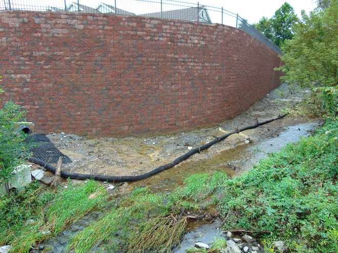
Another Wall— Here’s an example of greed by the owner, engineer, and municipality… placing their financial interests first. The entire floodplain on the north side of this stream was filled, then the wall was erected to contain the material. A financial institution’s office and parking lot was constructed atop the mound. This project has channelized the stream and completely displaced half of the floodplain to a height of 15 to 20 feet. Constructed less than five years ago, the wall failed already and has just been totally reconstructed. The photo reveals how recent flooding has begun a new erosion regime where energy is focused along the base of the wall. Impairment of a floodplain to this degree can lead to flooding upstream of the site and erosion damage to neighboring infrastructure including roads and bridges.The floodplain along this segment of the lower Swatara Creek in Londonderry Township, Dauphin County is free to flood. Ordinances prohibit new construction here and 14 older houses that repeatedly flooded were purchased, dismantled, and removed using funding from the Federal Emergency Management Agency (F.E.M.A). A riparian buffer was planted and some wetland restorations were incorporated into stormwater management installations along the local highways. When the waters of the Swatara rise, the local municipality closes the roads into the floodplain. Nobody lives or works there anymore, so no one has any reason to enter. There’s no need to rescue stubborn residents who refused advice to evacuate. Sightseers can park and stand on the hill behind the barricades and take all the photographs they like.A new Pennsylvania Turnpike bridge across Swatara Creek features wide passage for the stream below. Water flowing in the floodplain can pass under the bridge without being channelized toward the path where the stream normally flows in the center. The black asterisk-shaped floats spin on the poles to help deflect debris away from the bridge piers. (flood crest on July 26, 2018)People are curious when a waterway floods and they want to see it for themselves. Wouldn’t it be wise to anticipate this demand for access by being ready to accommodate these citizens safely? Isn’t a parking lot, picnic area, or manicured park safer and more usable when overlooking the floodplain as opposed to being located in it? Wouldn’t it be a more prudent long-term investment, both financially and ecologically, to develop these improvements on higher ground outside of flood zones?Now would be a good time to stop the new construction and the rebuilding in floodplains. Aren’t the risks posed to human life, water quality, essential infrastructure, private property, and ecosystems too great to continue?Isn’t it time to put up the white flag and surrender the floodplains to the floods? That’s why they’re there. Floodplains are for flooding.
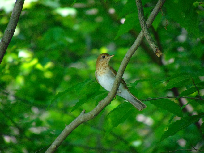
One can get a stiff neck looking up at the flurry of bird activity in the treetops at this time of year. Many of the Neotropical migrants favor rich forests as daytime resting sites after flying through the night. For others, these forests are a destination where they will nest and raise their young.
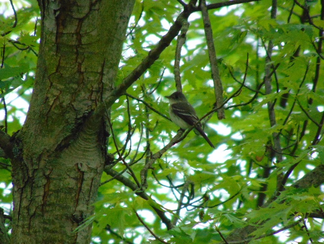
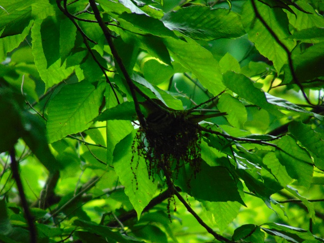
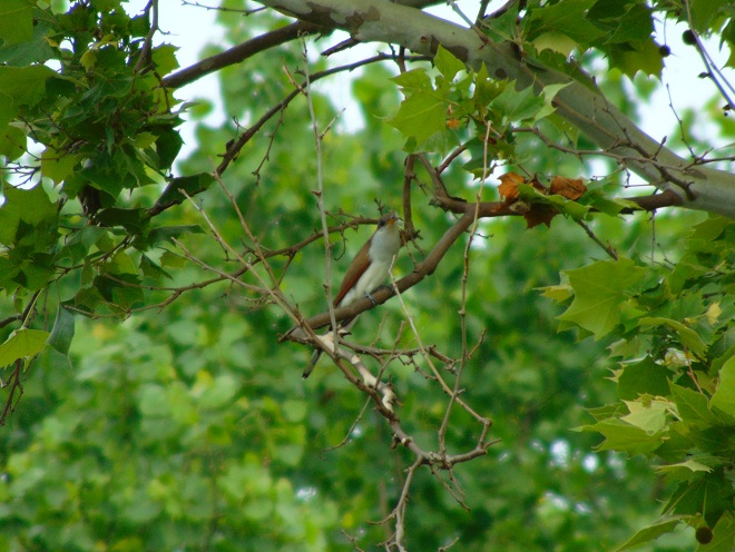
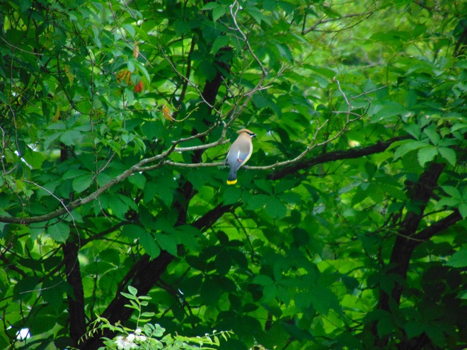
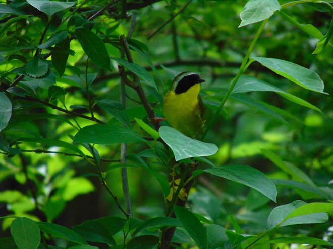
The Veery (Catharus fuscescens) is a Neotropical thrush that breeds in extensive mature forest on the dampest slopes of the Diabase ridges in the Gettysburg Basin. Their rolling flute-like songs echo through the understory as newly arrived birds establish nesting territories.The whistled song of the Baltimore Oriole is often heard long before this colorful Neotropical is seen among the foliage of a treetop. Some dead branches allow us a glimpse of this curious beauty.The “Pee-a-wee……..Pee-urr” song of the Eastern Wood-Pewee (Contopus virens), a small flycatcher, is presently heard in the Riparian Woodlands at Conewago Falls. It breeds in forested tracts throughout the lower Susquehanna valley. The vocalizations often continue through the summer, ending only when the birds depart to return to the tropics for the winter.While constructing a nest beneath a tree canopy, an Eastern Wood-Pewee form-fits the cup where eggs will soon be laid.The Yellow-billed Cuckoo (Coccyzus americana) nests in the treetops of Riparian Woodlands along the Susquehanna and its tributaries. Most arrive during the second half of May for their summer stay. It is a renowned consumer of caterpillars.The Cedar Waxwing is a notorious wanderer. Though not a Neotropical migrant, it is a very late nester. Flocks may continue moving for another month before pairs settle on a place to raise young.Of the more than twenty species of warblers which regularly migrate through the lower Susquehanna Valley, the Common Yellowthroat (Geothlypis trichas) is among those which breeds here. It is particularly fond of streamside thickets.
For the birds that arrive earlier in spring than the Neotropical migrants, the breeding season is well underway. The wet weather may be impacting the success of the early nests.
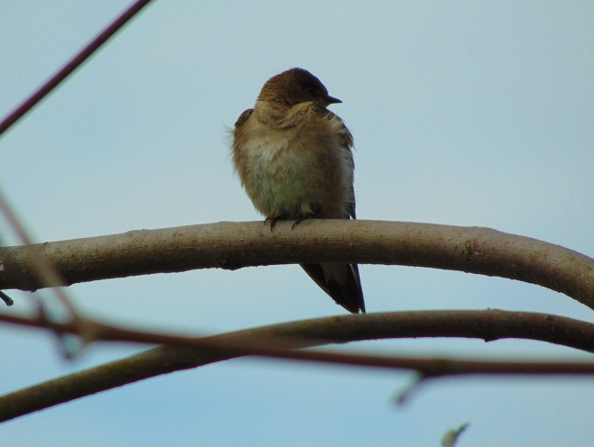
Northern Rough-winged Swallows arrived back in April. At traditional nest sites, including the York Haven Dam and local creek bridges, small groups of adults were seen actively feeding and at times perching in dead treetops during recent days. There was an absence of visits to the actual nest cavities where they should be feeding and fledging young by now. It’s very possible that these nests failed due to the wet weather and flooding. Another nest attempt may follow if drier conditions allow stream levels to subside and there is an increase in the mass of flying insects available for the adults to feed to their young..A Carolina Chickadee, a resident species, is seen atop a hollow stump where it and a mate are constructing a new nest for a second brood. Did the first brood fail? Not sure.Common Mergansers are an uncommon but regular nesting species of waterfowl on the lower Susquehanna River. They nest in cavities, requiring very large trees to accommodate their needs. It was therefore encouraging to see this pair on a forested stream in northern Lancaster County during the weekend. However, a little while after this photograph was taken the pair flew away, indicating that they are not caring for young which by now should be out of the nest and on the move under the watchful care of the female.
So long for now, if you’ll excuse me please, I have a sore neck to tend to.
Two days ago, widespread rain fell intermittently through the day and steadily into the night in the Susquehanna drainage basin. The temperature was sixty degrees, climbing out of a three-week-long spell of sub-freezing cold in a dramatic way. Above the ice-covered river, a very localized fog swirled in the southerly breezes.
By yesterday, the rain had ended as light snow and a stiff wind from the northwest brought sub-freezing air back to the region. Though less than an inch of rain fell during this event, much of it drained to waterways from frozen or saturated ground. Streams throughout the watershed are being pushed clear of ice as minor flooding lifts and breaks the solid sheets into floating chunks.
Today, as their high flows recede, the smaller creeks and runs are beginning to freeze once again. On larger streams, ice is still exiting with the cresting flows and entering the rising river.
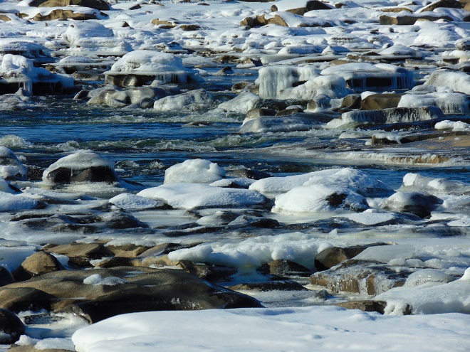
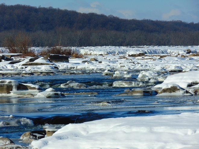
Ice chunks on Swatara Creek merge into a dense flow of ice on the river in the distance. Swatara Creek is the largest tributary to enter the Susquehanna in the Gettysburg Basin. The risk of an ice jam impounding the Swatara here at its mouth is lessened because rising water on the river has lifted and broken the ice pack to keep it moving without serious impingement by submerged obstacles. Immovable ice jams on the river can easily block the outflow from tributaries, resulting in catastrophic flooding along these streams.Fast-moving flows of jagged ice race toward Three Mile Island and Conewago Falls. The rising water began relieving the compression of ice along the shoreline during the mid-morning. Here on the river just downstream of the mouth of Swatara Creek, ice-free openings allowed near-shore piles to separate and begin floating away after 10:30 A.M. E.S.T. Moving masses of ice created loud rumbles, sounding like a distant thunderstorm.Ice being pushed and heaved over the crest of the York Haven Dam at Conewago Falls due to compression and rising water levels.Enormous chunks of ice being forced up and over the York Haven Dam into Conewago Falls and the Pothole Rocks below.Ice scours Conewago Falls, as it has for thousands of years.The action of ice and suspended abrasives has carved the York Haven Diabase boulders and bedrock of Conewago Falls into the amazing Pothole Rocks.The roaring torrents of ice-choked water will clear some of the woody growth from the Riverine Grasslands of Conewago Falls.To the right of center in this image, a motorcar-sized chunk of ice tumbles over the dam and crashes into the Pothole Rocks. It was one of thousands of similar tree-and-shrub-clearing projectiles to go through the falls today.
The events of today provide a superb snapshot of how Conewago Falls, particularly the Diabase Pothole Rocks, became such a unique place, thousands of years in the making. Ice and flood events of varying intensity, duration, and composition have sculpted these geomorphologic features and contributed to the creation of the specialized plant and animal communities we find there. Their periodic occurrence is essential to maintaining the uncommon habitats in which these communities thrive.
Fish Crows (Corvus ossifragus) gather along the flooding river shoreline. Soon there’ll be plenty of rubbish to pick through, some carrion maybe, or even a displaced aquatic creature or two to snack upon.
Is this the same Conewago Falls I visited a week ago? Could it really be? Where are all the gulls, the herons, the tiny critters swimming in the potholes, and the leaping fish? Except for a Bald Eagle on a nearby perch, the falls seems inanimate.
Yes, a week of deep freeze has stifled the Susquehanna and much of Conewago Falls. A hike up into the area where the falls churns with great turbulence provided a view of some open water. And a flow of open water is found downstream of the York Haven Dam powerhouse discharge. All else is icing over and freezing solid. The flow of the river pinned beneath is already beginning to heave the flat sheets into piles of jagged ice which accumulate behind obstacles and shallows.
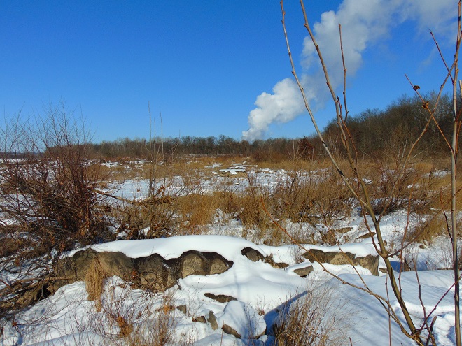
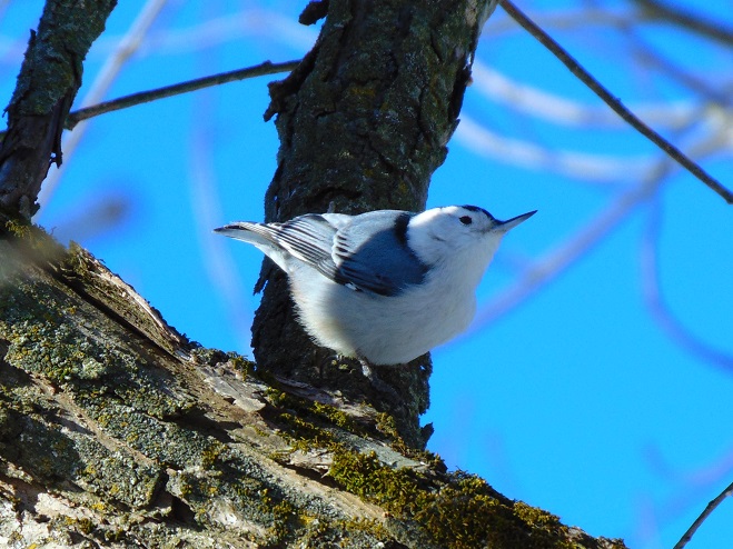
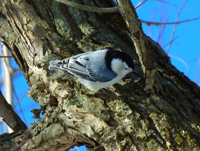
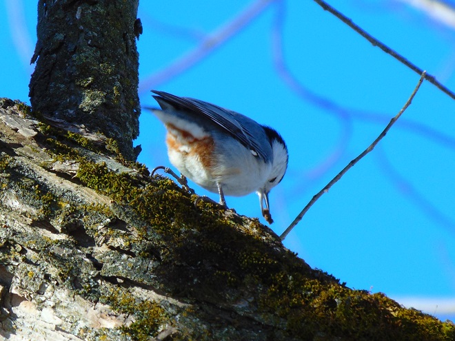
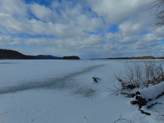
Ice and snow surround a small zone of open water in a high-gradient area of Conewago Falls.Ice chunks and sheets accumulate atop the York Haven Dam. The weight of miles of ice backed up behind the dam eventually forces the accumulation over the top and into the Pothole Rocks below. The popping and cracking sounds of ice both above and below the dam could be heard throughout the day as hydraulic forces continuously break and move ice sheets.Steam from the Unit 1 cooling towers at the Three Mile Island Nuclear Generating Station rises above the frozen Riverine Grasslands at Conewago Falls. The scouring action of winter ice keeps the grasslands clear of substantial woody growth and prevents succession into forest.Despite a lack of activity on the river, mixed flocks of resident and wintering birds, including this White-breasted Nuthatch (Sitta carolinensis), were busy feeding in the Riparian Woodlands. The White-breasted Nuthatch is a cavity nester and year-round denizen of hardwoods, often finding shelter during harsh winter nights in small tree holes.The White-breasted Nuthatch is often seen working its way head-first down a tree trunk as it probes with its well-adapted bill for insects among the bark.Jackpot!Looking upstream from the river’s east shore at ice and snow cover on the Susquehanna above Conewago Falls and the York Haven Dam. The impoundment, known as Lake Frederic, and its numerous islands of the Gettysburg Basin Archipelago were locked in winter’s frosty grip today. Hill Island (Left) and Poplar Island (Center) consist of erosion-resistant York Haven Diabase, as does the ridge on the far shoreline seen rising in the distance between them. To the right of Poplar Island in this image, the river passes by the Harrisburg International Airport. At the weather station there, the high temperature was eighteen degrees Fahrenheit on this first day of 2018.
It was one of the very first of my memories. From the lawn of our home I could look across the road and down the hill through a gap in the woodlands. There I could see water, sometimes still with numerous boulders exposed, other times rushing, muddy, and roaring. Behind these waters was a great stone wall and beyond that a wooded hillside. I recall my dad asking me if I could see the dam down there. I couldn’t see a dam, just fascinating water and the gray wall behind it. I looked and searched but not a trace of a structure spanning the near to far shore was to be seen. Finally, at some point, I answered in the affirmative to his query; I could see the dam…but I couldn’t.
We lived in a small house in the village of Falmouth along the Susquehanna River in the northwest corner of Lancaster County over fifty years ago. A few years after we had left our riverside domicile and moved to a larger town, the little house was relocated to make way for an electric distribution sub-station and a second set of electric transmission wires in the gap in the woodlands. The Brunner Island coal-fired electric generating station was being upgraded downstream and, just upstream, a new nuclear-powered generating station was being constructed on Three Mile Island. To make way for the expanding energy grid, our former residence was trucked to a nearby boat landing where there were numerous other river shacks and cabins. Because it was placed in the floodplain, the building was raised onto a set of wooden stilts to escape high water. It didn’t help. The record-breaking floods of Hurricane Agnes in June of 1972 swept the house away.
The view through the cut in the woodland, a little wider than in the early 1960s with the addition of the newer electric transmission wire towers. The “Wall” is the same.
During the time we lived along the Susquehanna, the river experienced record-low flow rates, particularly in the autumn of 1963 and again in 1964. My dad was a dedicated 8mm home-movie photographer. Among his reels was film of buses parked haphazardly along the road (PA Route 441 today) near our home. Sightseers were coming to explore the widely publicized dry riverbed and a curious moon-like landscape of cratered rocks and boulders. It’s hard to fathom, but people did things like that during their weekends before Sunday-afternoon football was invented. Scores of visitors climbed through the rocks and truck-size boulders inspecting this peculiar scene. My dad, his friends, and so many others with camera in hand were experiencing the amazing geological feature known as the Pothole Rocks of Conewago Falls.
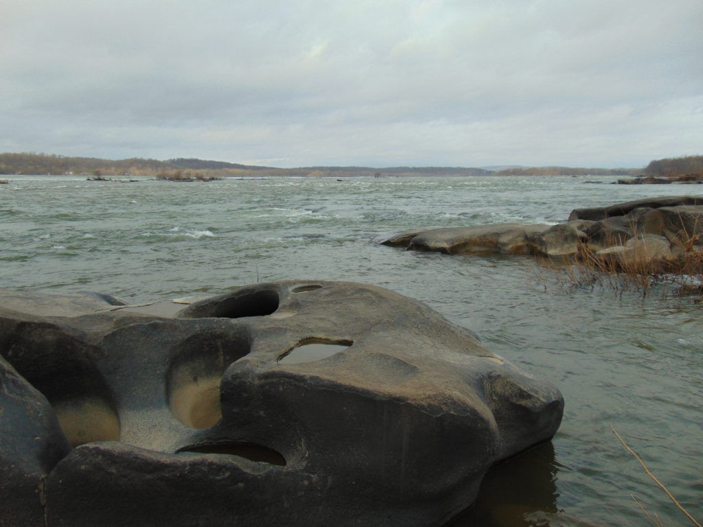
Conewago Falls on the Susquehanna River and several exposed York Haven Diabase Pothole Rocks. Lancaster (foreground) and Dauphin (center) Counties meet along a southwest to northeast borderline through the rapids. Lands on the west shoreline in the background are in York County. Three Mile Island is seen in the upper right.
The river here meets serious resistance as it pushes its way through the complex geology of south-central Pennsylvania. These hard dark-gray rocks, York Haven Diabase, are igneous in origin. Diabase sheets and sills intruded the Triassic sediments of the Gettysburg Formation here over 190 million years ago. It may be difficult to visualize, but these sediments were eroded from surrounding mountains into the opening rift valley we call the Gettysburg Basin. This rift and others in a line from Nova Scotia to Georgia formed as the supercontinent Pangaea began dividing into the continents we know today. Eventually the Atlantic Ocean rift would dominate as the active dynamic force and open to separate Africa from North America. The inactive Gettysburg Basin, filled with sediments and intruded by igneous diabase, would henceforth, like the mountainous highlands surrounding it, be subjected to millions of years of erosion. Of the regional rocks, the formations of Triassic redbeds, sandstones, and particularly diabase in the Gettysburg Basin are among the more resistant to the forces of erosion. Many less resistant older rocks, particularly those of surrounding mountains, are gone. Today, the remains of the Gettysburg Basin’s rock formations stand as rolling highlands in the Piedmont Province.
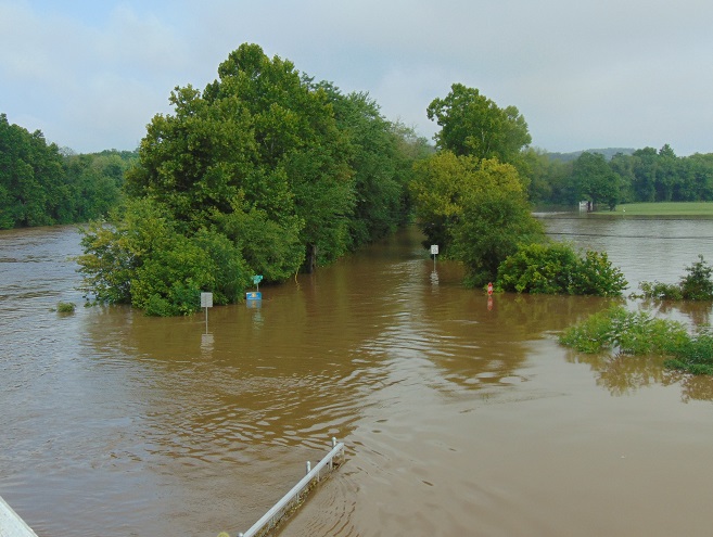
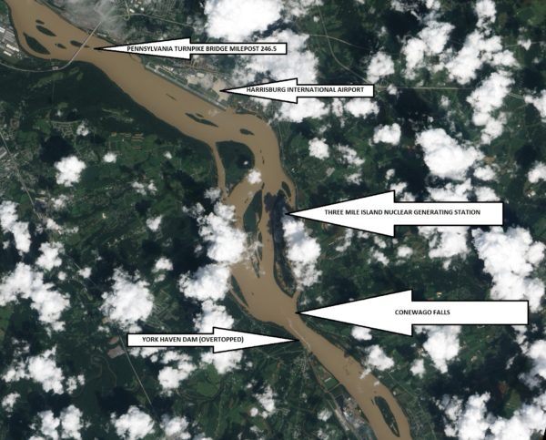
Flooded from the heavy rains of Tropical Storm Lee, the sediment-laden Susquehanna River flows through the Gettysburg Basin just south of Harrisburg, PA, September 10, 2011. The “Wall” as seen from space. (NASA Earth Observatory Image)
The weekend visitors in 1963 and 1964 marveled at evidence of the river’s fight to break down the hard York Haven Diabase. Scoured bedrock traced the water’s turbulent flow patterns through the topography of the falls. Meltwater from the receding glaciers of the Pleistocene Ice Ages thousands to tens of thousands of years ago raged in high-volume, abrasive-loaded torrents to sculpt the Pothole Rocks into the forms we see today. Our modern floodwaters with ice and fine suspended sediments continue to wear at the smooth rocks and boulders, yet few are broken or crumbled to be swept away. It’s a very slow process. The river elevation here drops approximately 19 feet in a quarter of a mile, a testament to the bedrock’s persisting resistance to erosion. Conewago Falls stands as a natural anomaly on a predominantly uniform gradient along the lower Susquehanna’s downhill path from the Appalachian Mountains to the Chesapeake Bay.
Normally the scene of dangerous tumbling rapids, the drought and low water of 1963 and 1964 had left the falls to resemble a placid scene—a moonscape during a time when people were obsessed with mankind’s effort to visit earth’s satellite. Visitors saw the falls as few others had during the twentieth century. Dr. Herbert Beck of Franklin and Marshall College described an earlier period of exposure, “…pot holes…were uncovered during the third week in October, 1947, for the first time in the memory of man, when the drought parched Susquehanna River retreated far below its normal low stage”. Then, as in 1963 and on occasions more recent, much of it was due to the presence of the wall. I had to be a bit older than four years old to grasp it. You see the wall and the dam are one and the same. The wall is the York Haven Dam. And it is responsible for channeling away the low flow of the Susquehanna during periods of drought so that we might have the opportunity to visit and explore the Pothole Rocks of Conewago Falls along the river’s east shore.
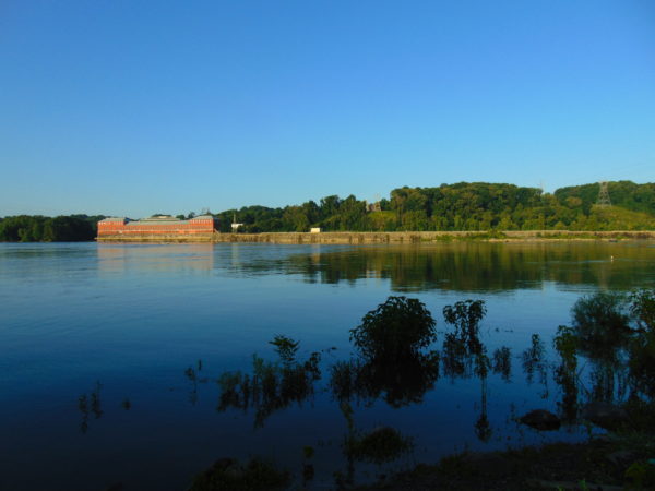
The initial segment of the dam, a crib structure built in 1885 by the York Haven Paper Company to supply water power to their mill, took advantage of the geomorphic features of the diabase bedrock of Conewago Falls to divert additional river flow into the abandoned Conewago Canal. The former canal, opened in 1797 to allow passage around the rapids along the west shore, was being used as a headrace to channel water into the grinding mill’s turbines. Strategic placement of this first wall directed as much water as possible toward the mill with the smallest dam practicable. The York Haven Power Company incorporated the paper mill’s crib dam into the “run-of-the-river” dam built through the falls from the electric turbine powerhouse they constructed on the west shore to the southern portion of Three Mile Island more than a mile away. The facility began electric generation in 1904. The construction of the “Red Hill Dam” from the east shore of Three Mile Island to the river’s east shore made York Haven Dam a complete impoundment on the Susquehanna. The pool, “Lake Frederic”, thus floods that portion of the Pothole Rocks of Conewago Falls located behind the dam. On the downstream side, water spilling over or through the dam often inundates the rocks or renders them inaccessible.
During the droughts of the early 1960s, diversion of nearly all river flow to the York Haven Dam powerhouse cleared the way for weekend explorers to see the Pothole Rocks in detail. Void of water, the intriguing bedrock of Conewago Falls below the dam greeted the curious with its ripples, cavities, and oddity. It was an opportunity nature alone would not provide. It was all because of the wall.
York Haven Dam and powerhouse. The “Wall” traverses Conewago Falls upstream to Three Mile Island to direct water to the powerhouse on the west shore of the Susquehanna River.
SOURCES
Beck, Herbert H. 1948. “The Pot Holes of Conewago Falls”. Proceedings of the Pennsylvania Academy of Science. Penn State University Press. 22: pp. 127-130.
Smith, Stephen H. 2015. #6 York Haven Paper Company; on the Site of One of the Earliest Canals in America. York Past website www.yorkblog.com/yorkpast/2015/02/17/6-york-haven-paper-company-on-the-site-of-one-of-the-earliest-canals-in-america/ as accessed July 17, 2017.
Stranahan, Susan Q. 1993. Susquehanna, River of Dreams. The Johns Hopkins University Press. Baltimore, Maryland.
Van Diver, Bradford B. 1990. Roadside Geology of Pennsylvania. Mountain Press Publishing Company. Missoula, Montana.