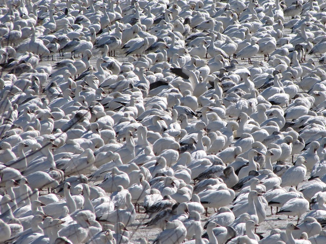
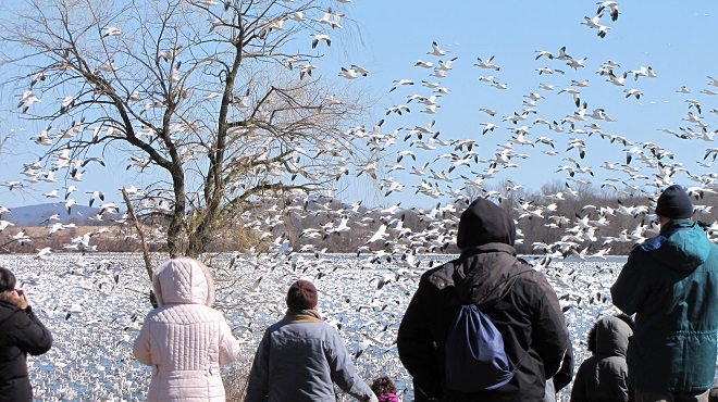
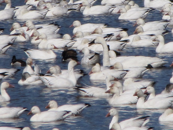
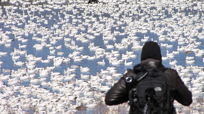
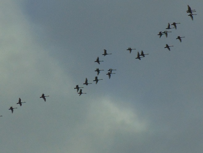
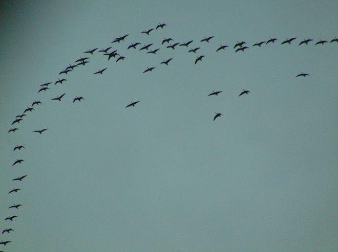
For those of you who may be wondering if there are Snow Geese at Middle Creek Wildlife Management Area, the answer is yes—just one!
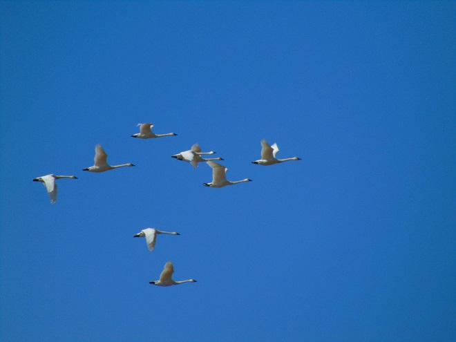
A lone Snow Goose was seen earlier today among about 100 Canada Geese, two dozen Tundra Swans, and a couple of American Black Ducks clustered around a small opening in the ice on the main impoundment at Middle Creek.
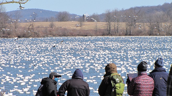
So where are the thousands of Snow Geese we’ve grown accustomed to seeing during recent decades as they gather at the refuge in February while preparing to fly north for the summer?
With much of the river and nearly all of the lower Susquehanna basin’s lakes and ponds frozen, Snow Geese and many other migratory waterfowl remain concentrated on the Atlantic Coastal Plain where salty tidewater provides ice-free conditions for feeding and loafing. In fact, some ducks, particularly diving species, may still be evacuating freshwater locations to our north such as the Eastern Great Lakes where, during the past week, even more surface area has succumbed to freezing. Look for migrants to begin pushing north in bigger numbers as soon as rising temperatures start to melt local ice. (NOAA/U.S. National Ice Center image)Freezing of the Great Lakes has not been this extensive since 2019. New lake ice (shown in pink) has completed coverage of Lake Erie (lower left), isolated open water from the shorelines of Lake Huron (upper left), and now covers a large portion of the nearshore waters of Lake Ontario (right). (NOAA/U.S. National Ice Center image)
As we begin the second half of October, frosty nights have put an end to choruses of annual cicadas in the lower Susquehanna valley. Though they are gone for yet another year, they are not forgotten. Here’s an update on one of our special finds in 2025.
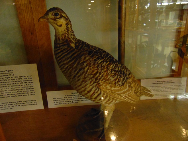
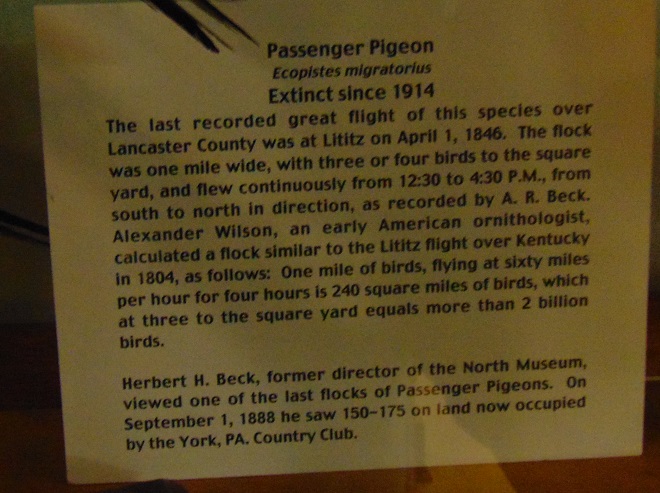
During late June of 1863, the beginning of the third summer of the American Civil War, there was great consternation among the populous of the lower Susquehanna region. Hoping to bring about Union capitulation and an end to the conflict, General Robert E. Lee and his 70,000-man Army of Northern Virginia were marching north into the passes and valleys on the west side of the river. The uncontested Confederate advances posed an immediate threat to Pennsylvania’s capital in Harrisburg and cities to the east. Marching north in pursuit of Lee was the First Corps of the Army of the Potomac, the lead element of the 100,000-man Union force under the direction of newly appointed commander General George G. Meade.
Upon belatedly learning of Meade’s pursuit, Lee hastily ordered the widely separated corps of his army to concentrate on the crossroads town of Gettysburg. As the southern army’s Third Corps under General A. P. Hill approached Gettysburg from the west, they were met by Union cavalry under the leadership of General John Buford. Dismounted and formed up south to north across the Chambersburg Pike, Buford’s men held off Confederate infantry until relieved by the arrival of the Union First Corps. As he deployed his men, the First Corps’ commander, General John F. Reynolds of Lancaster, was struck by a bullet and killed.
During the first day’s fighting at Gettysburg on July 1, 1863, the northernmost position in the Union First Corps’ line was held by its Second Division commanded by General John C. Robinson. His men would defend their right flank against attacks from Confederate General Richard S. Ewell’s Second Corps as they arrived from the north to face off against the Union Eleventh Corps which had arrived to take positions north of the town. During the afternoon, upon becoming outnumbered and overwhelmed, the Union forces would retreat south through the town to take up positions on Cemetery Hill by nightfall. Deployments extending south and east of Cemetery Hill would ultimately prove victorious for Union forces during the battle’s final day on July 3.John C. Robinson’s Second Division “invaded” Pennsylvania as one of Meade’s lead elements charged with intercepting Lee’s Confederate Army. (National Park Service image)
If you visit the Gettysburg battlefield, you can find the General John C. Robinson monument at the site of his division’s first-day position along Doubleday Avenue at Robinson Avenue near the Eternal Light Peace Memorial. But that’s not the Robinson we went to Gettysburg to see.
Following up on our sight and mostly sound experiences with some Robinson’s Cicadas, an annual species of singing insect we found thriving at Gifford Pinchot State Park in York County, Pennsylvania, during late July, we spent some time searching out other locations where this native invader from the southern United States could be occurring in the Lower Susquehanna River Watershed.
During mid-August, we stumbled upon a population of Robinson’s Cicadas east of the Susquehanna in the Conewago Creek (east) watershed in Londonderry Township, Dauphin County, and made some sound recordings.
After pondering this latest discovery, we decided to investigate places with habitat characteristics similar to those at both the new Londonderry Township and the earlier Gifford Pinchot State Park locations—successional growth with extensive stands of Eastern Red Cedar on the Piedmont’s Triassic Gettysburg Formation “redbeds”. We headed south towards known populations of Robinson’s Cicadas in Virginia and Maryland to look for suitable sites within Pennsylvania that might bridge the range gap.
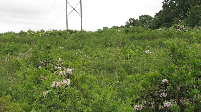
Our search was a rapid success. On State Game Lands 249 in the Conewago Creek (west) watershed in Adams County, we found Robinson’s Cicadas to be widespread.
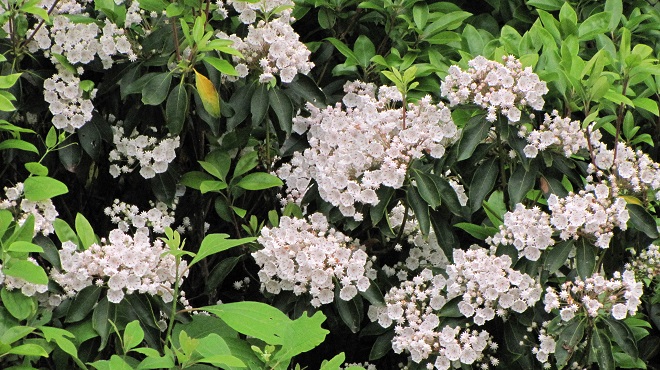
Eastern Red Cedar, a probable host tree for Robinson’s Cicada nymphs, among successional growth on State Game Lands 249. Cedar thickets often become established on shallow or depleted soils on lands originally cleared for farming. They provide excellent cover as well as much needed breeding and feeding areas for birds, mammals, insects, and other wildlife.A male Robinson’s Cicada singing at State Game Lands 249 in Adams County, Pennsylvania.
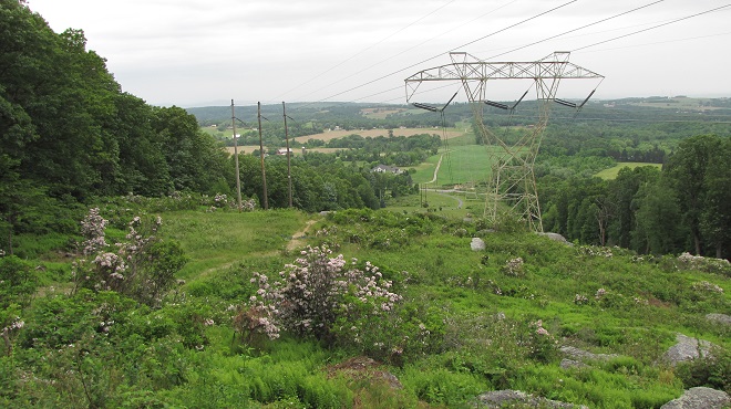
Following our hunch that these lower Susquehanna Robinson’s Cicadas extended their range north through the cedar thickets of the Gettysburg Basin as opposed to hopping the Appalachians from a population reported to inhabit southwest Pennsylvania, we made our way to the battlefield and surrounding lands. We found Robinson’s Cicadas to be quite common and widespread in these areas, even occurring in the town of Gettysburg itself.
Populations of Robinson’s Cicadas (red) in the lower Susquehanna valley and adjacent areas of the Potomac watershed near Gettysburg. The Triassic Gettysburg Basin is shown in white with intrusions of igneous Triassic-Jurassic diabase in dark green. (United States Geological Survey base image)Robinson’s Cicadas are common on much of the Gettysburg National Military Park property, particularly in the southern reaches where outlying areas are dense with Eastern Red Cedar growth to within several miles of the Mason-Dixon Line. In these tall walnuts and cedars along Confederate Avenue (that’s Little Round Top and its diabase boulders in the background) we recorded the following sound clip of a singing male.Robinson’s Cicada probably extended its range into the lower Susquehanna valley in much the same way General John C. Robinson and the rest of the Army of the Potomac marched into Pennsylvania to meet Lee’s Confederates, by following the terrain of the Triassic Gettysburg Basin. Got a big stand of cedars near you? Be sure to have a listen for Robinson’s Cicadas next summer! (United States Geological Survey base image)
Today’s NOAA/GOES satellite image serves as a little reminder of the big three. That’s right, it’s the three big “natural” disasters—wildfires, inland flooding, and coastal flooding (lucky for us, our region is at present millions of years removed from severe threats posed by the tectonic disasters—earthquakes, volcanoes, and tsunamis—and is not particularly prone to frequent tornadoes). Each continues to cause an increasing volume of property damage and threaten a greater number of lives because of where and how we choose to make our homes and erect our structures.
Earlier today, smoke from forest fires in central Canada sweeps through the skies of the Great Lakes, New England, and the Mid-Atlantic States north of the Mason-Dixon Line. Meanwhile off North Carolina, Tropical Storm Dexter is seen developing over warm ocean waters east of the Gulf Stream. (NOAA/GOES satellite image)
For all of human existence, the dynamics of the atmosphere have been shaping the topography and the ecosystems of the planet. In recent times, we’ve had the advantage of satellite technologies to show us spectacular images of atmospheric events as they happen. And through the various branches of science, we’ve come to understand the impact these events have upon the landscape and the people who live and/or work there.
Forestry sciences have helped us to understand how natural fuels, humidity, temperature, rainfall, soil moisture, wind, and human encroachment influence the frequency and severity of wildfires. These discoveries have led to changes in forest management and implementation of practices such as prescribed burns to reduce accumulated fuel loads. Because human development typically lowers soil moisture and brings along with it additional sources of ignition, many land managers and fire departments have warned of the ever increasing dangers of wildland-urban interface fires. These warnings have gone largely unheeded for more than four decades as millions of homes and other combustible structures have been erected within areas prone to fires capable of uncontrollable growth into disastrous conflagrations. The tinderbox wildlands—they’re a nice place to visit, but we ought not to live there!
Tropical storms and other sources of heavy precipitation bring about quite the hubbub over flooding. Meteorologists spend a lot of time explaining it all, but it’s almost as if no one pays any mind. For a people who check the weather forecast several times a day, every day of our adult life, just to get a leg up on how that weather is going to change day by day and hour by hour, you would think we would better anticipate the climatic events that happen over the long term. In particular, you would think we would have an awareness of our own individual susceptibility to flooding— a grasp of how, where, and why floods occur. You would think that repeated episodes of flooding would compel society to embrace an ethic that treated water as the valuable commodity it is. Yet, we all seem to follow the same patterns of behavior. First, we drain, dump, pipe, curb, channel, ditch, grade, pave, and pump to get the rain that falls upon our property off of our property. Then, the chump downstream gets really mad that we sent our water his way and flooded him out, so he takes the same measures to send even more water to the next poor slob down the line until finally the now polluted slurry of runoff floods the street, a cellar, a house, a business, or a stream—a stream that has been channelized so it no longer has a floodplain to absorb, hold, purify, and infiltrate the stormwater. Why was the stream channelized? So we could fill in the floodplain and build upon it of course. Two things come to mind here. First, if we’re going to be selfish enough to flood out our neighbors, then why shouldn’t we be totally selfish and keep for ourselves all the water that falls upon our place. After all, we’re going to need that water some day. And second, the floodplain is a nice place to visit, but we ought not to build there. Floodplains are for flooding; thousands of years of erosion have shaped them that way—it’s a gravity thing!
Next, we look at the lessons from geology, more specifically coastal geomorphology. Through these disciplines we know that the coastal plain—the flat land that spent most of the last 35.5 million years (the time since the meteor strike at the present-day mouth of Chesapeake Bay) as a beach or a tidal marsh—today stands mostly less than three dozen feet above sea level. We know that the sands forming barrier islands along the Atlantic seaboard, which are only several feet above sea level, shift their shape and position with the tides. Over the decades and centuries, these islands migrate and compensate for changes in climate and tidal patterns as well as sea levels. Behind their shifting dunes, vast tidal marshes are protected from seasonal storms including the periodic nor’easter or hurricane. Despite the importance of barrier island dynamics to the integrity of the bays and estuaries they protect, and despite their vulnerability to coastal storm surges, winds, and flooding, we choose to build there. In fact, the greatest population densities in the United States, and in many other countries of the world, are on the beach. It’s not because these hundreds of millions of people are fishing or loading/unloading ships for a living—it’s mostly for the view. Despite their importance to fisheries and other coastal life, we continue to alter and destroy the near-tidal areas of the the barrier islands and bays. We go to great expense to “save” for our uses the lands that should be getting inundated by rising sea levels to create new shallow tidewater zones. We waste spectacular amounts of money pumping sand back onto beaches to keep naturally migrating sediments from changing their shape and position in response to the tides. We keep putting more people and more capital at risk by urbanizing these low-lying areas. Building on the beach is absolute madness. It’s an ecological catastrophe from day one and a human catastrophe soon after.
All of the lands impacted by these natural events have two things in common. Each becomes a potential disaster area if people choose to construct their homes or businesses there. And each, if left in its wild state and given a buffer space from human activity, reacts with natural time-derived mechanisms in response to the same events. These mechanisms are often essential for provision of the unique ecosystems required by many of our most threatened wildlife species. Human encroachment into floodplains, wetlands, tidal marshes, beaches, and xeric uplands is a double-edged sword. It first decimates populations of these uncommon species by destroying and fragmenting their specialized habitats. Then, it sets the stage for the fires, floods, and other disasters that endanger the lives and property of the people living there. Considering the ramifications of building in these fire and flood susceptible areas, we can and should live somewhere else, especially when the wildlife requiring these places often can’t.
This evening’s smoky sunset over the Susquehanna at Chiques Rock was courtesy of Canadian wildfires.
We’ve seen worse, but this winter has been particularly tough for birds and mammals in the Lower Susquehanna River Watershed. Due to the dry conditions of late summer and fall in 2024, the wild food crop of seeds, nuts, berries, and other fare has been less than average. The cold temperatures make insects hard to come by. Let’s have a look at how some of our local generalist and specialist species are faring this winter.
House Sparrows (bottom) and House Finches (top) are generalists. To survive and thrive, they are adapted to a variety of habitats and types of food. House Sparrows live almost anywhere man-made structures are found. They are true omnivores and will eat almost anything, especially if they see something else try to eat it first. The House Sparrow’s close association with humans has allowed it to become the most widespread and successful living avian dinosaur. On a cold night, they’ll take shelter either within dense vegetation alongside a building or within the structure itself. Though not nearly as cosmopolitan, the House Finch has successfully colonized much of the eastern United States after escaping from captivity as a cage bird in New York during the middle of the twentieth century. Upon being trans-located here from the arid southwest, they adapted to suburbs and farmlands consuming primarily a granivore diet of seeds supplemented with seasonally available berries. They quickly became accustomed to offerings at bird-feeding stations as well. To survive the harsh winters in the northern sections of their range, eastern populations of House Finches are developing a pattern of migration. These movements are most evident in late fall when dozens or sometimes hundreds can be seen heading south over regional hawk-counting stations.Though they require dead trees for nesting and as places to find the grubs and adult insects upon which they primarily feed, woodpeckers including the Northern Flicker are generalists, seldom passing by a supply of fruits like these Poison Ivy berries as a source of winter food. Flickers regularly visit suburban areas where they’ll drop by at bird-feeding stations for suet. During the warmer months, they are the woodpecker most frequently seen on the ground where swarms of ants garner their full attention.The Pileated Woodpecker is seldom found outside of mature forests where it digs relentlessly to remove grubs and other infestations from dead wood. But it is not a true specialist……it too finds a supply of Poison Ivy berries to be indispensable during a cold winter day.The Ruby-crowned Kinglet is a generalist, feeding mostly on insects, but also consuming small seeds and some berries, including those of Poison Ivy. It nests well to our north in tall spruces and other evergreens. During migration and in winter, the Ruby-crowned Kinglet may be found in deciduous trees, brush, and tall grass in habitats ranging from forests to parks and suburbia. This male is displaying its seldom-seen red crown.The Golden-crowned Kinglet, seen here on a Poison Ivy vine, is more of a specialist than the Ruby-crowned species, though the two will often occur in mixed groups during the winter. The Golden-crowned Kinglet nests in Spruce-Fir forests and in conifers within mixed woodlands. Even during migration, and particularly in winter, these birds are seldom found far from a stand of large evergreens within which they find shelter for the night.The Hermit Thrush’s generalist lifestyle allows it to survive cold season weather in the Lower Susquehanna River Watershed. During summer, it breeds in coniferous and mixed woods from the northern parts of our valley north into Canada and feeds primarily on worms, insects, and other arthropods. During migration and in winter, the Hermit Thrush becomes a regular visitor to deciduous forests, woody parks and suburbs, particularly where a supply of wild berries is available to supplement its diet.Iconic as it pulls earthworms from lawns during the warmer months, the generalist American Robin is fully dependent upon a crop of berries to survive winter conditions in the lower Susquehanna valley. The drought afflicted wild food crop of 2024 has led to fewer robins spending the season here and has delayed the northward push of migrating birds until the ground thaws and the earthworms make the ground rumble once again.It’s insects for the nestlings during spring and summer, then berries through the winter for the cheerful Eastern Bluebirds, another generalist species.American Crows are an excellent example of a generalist species. They’ll go anywhere to find food and they’ll eat almost anything. Like the House Sparrow and several other generalists, they adapt very well to human activity and actually thrive on it. Garbage anyone?Another career generalist is the widely worshiped White-tailed Deity, a species adapted to nearly all man-made landscapes with adequate vegetation upon which to browse. Pushed to the limit during severe weather, some individuals will consume carrion and even resort to cannibalism.You might think the Great Blue Heron is a specialist. Nope, it’s an accomplished generalist. Great blues will live, feed, and breed on almost any body of fresh or brackish water. And their diet includes almost anything that swims. In winter, you’ll even see them in fields hunting mice and voles.The Red-shouldered Hawk is a generalist with a diet ranging from amphibians and reptiles to small rodents and large insects. Mostly regarded as a species of bottomlands, they’ll frequent woodland edges, roadsides, and suburbia during the winter months.During its periodic winter visits to the region, the American Tree Sparrow feeds on seeds among the grasses and forbs of semi-open country with scattered short shrubs and trees. A generalist species, it will show up at backyard bird-feeding stations, particularly during periods of inclement weather. In summer, the American Tree Sparrow nests in tundra with growths of stunted willows and spruce and their diet includes insects as a source of protein for themselves and their young.The White-crowned Sparrow has similar winter habitat preferences to the tree sparrows……it becomes adaptable and something of a generalist when searching for food during bad winter storms.The Savannah Sparrow is an omnivore favoring insects in summer and seeds in winter. Though very closely tied to its grassland habitat year-round, snow cover can push these birds to enter woodier environs to consume fruits like these rose hips.Dusk and dawn during the short days of winter are the prime hunting times of a mammal specialist, the Short-eared Owl. Its presence in the lower Susquehanna valley is dependent on two dominant factors: extensive grassland habitat and an adequate population of the owl’s favored food, the Meadow Vole (Microtus pennsylvanicus). The Short-eared Owl’s requirements as a specialist species make finding a suitable place to live difficult. Unlike the generalist birds and mammals that often adapt to the widespread man-made disturbances in the region, populations of specialists frequently become fragmented, reduced in abundance, and subject to extirpation.The Meadow Vole is a generalist rodent that can be abundant in grasslands, early successional growth, fallow fields, marshlands, and, of course, meadows. They are primarily herbivores, but will occasionally consume insects and other arthropods. Usually nocturnal, some individuals venture out along their surface runways during daylight hours becoming vulnerable to diurnal raptors including kestrels, harriers, and buteos.A Short-eared Owl in near darkness patrolling a grassland for Meadow Voles.The eastward expansion of the Coyote (Canis latrans), a species of western North America’s grasslands and scrublands, and its progressive mixing with the Wolf (Canis lupus) in these eastern extensions of its range, has produced an expanding population of very adaptable generalists we call Eastern Coyotes (Canis latrans var.). These omnivorous canines colonized the Lower Susquehanna River Watershed during the last four decades to replace extirpated wolves as the top-tier natural predator in the region. Their primary diet includes Meadow Voles in grasslands and other small mammals along woodland edges and in successional habitats. Seasonally, they consume the berries of numerous wild plants. Slightly larger than their western ancestors, Eastern Coyotes with the admixture of Wolf genetics can subdue small ungulates. Like other apex predators, they are attracted to vulnerable prey and thus play a crucial role in culling the weak and diseased among their potential quarry species to assure the health and potential of populations of these species as long-term sources of food energy. The benefit to the prey species is however largely diluted in populous areas of the northeast; most venison consumed by Eastern Coyotes here is in the form of road kill. During periods of extended snow cover when small rodents and other foods become inaccessible, Eastern Coyotes, particularly young individuals, will wander into new areas seeking sustenance. Sometimes they venture into cities and suburbs where they explore the neighborhoods in search of garbage and pet foods placed outside the home. (Video clip courtesy of Tyler and Grace Good. Click image to view.)
Wildlife certainly has a tough time making it through the winter in the lower Susquehanna valley. Establishing and/or protecting habitat that includes plenty of year-round cover and sources of food and water can really give generalist species a better chance of survival. But remember, the goal isn’t to create unnatural concentrations of wildlife, it is instead to return the landscape surrounding us into more of a natural state. That’s why we try to use native plants as much as possible. And that’s why we try to attract not only a certain bird, mammal, or other creature, but we try to promote the development of a naturally functioning ecosystem with a food web, a diversity of pollinating plants, pollinating insects, and so on. Through this experience, we stand a better chance of understanding what it takes to graduate to the bigger job at hand—protecting, enhancing, and restoring habitats needed by specialist species. These are efforts worthy of the great resources that are sometimes needed to make them a success. It takes a mindset that goes beyond a focus upon the welfare of each individual animal to instead achieve the discipline to concentrate long-term on the projects and processes necessary to promote the health of the ecosystems within which specialist species live and breed. It sounds easier than it is—the majority of us frequently become distracted.
Being an individual from a population of a very successful generalist species is no guarantee of survival. This Eastern Gray Squirrel fell from a tall tree when the limbs became ice covered during a storm earlier this month. Just a freak accident? Maybe, but mistakes like this are often fatal in the natural world. This squirrel’s passing may seem brutal, but it provides a better opportunity for other squirrels and animals that share its food and cover requirements to make it through the winter. And those survivors that didn’t suffer such a fatal mistake or, more importantly, don’t possess a vulnerability that may have contributed to such a mishap will have a chance to pass those traits on to a new generation. This squirrel as an individual is gone, its species lives on, and may be stronger for its passing.Pennsylvania Game Commission crews maintain a grassland ecosystem for Short-eared Owls and other specialists using prescribed fire to prevent succession beyond its earliest stages. Among the additional specialist species benefiting from this management tool are Monarchs and other butterflies whose host plants survive early-season fire, but not competition with woody vines, shrubs, trees, and invasive herbaceous growth.
On the wider scale, it’s of great importance to identify and protect the existing and potential future habitats necessary for the survival of specialist species. And we’re not saying that solely for their benefit. These protection measures should probably include setting aside areas on higher ground that may become the beach intertidal zone or tidal marsh when the existing ones become inundated. And it may mean finally getting out of the wetlands, floodplains, and gullies to let them be the rain-absorbing, storm-buffering, water purifiers they spent millennia becoming. And it may mean it’s time to give up on building stick structures on tinderbox lands, especially hillsides and rocky outcrops with shallow, eroding soils that dry to dust every few years. We need to think ahead and stop living for the view. If you want to enjoy the view from these places, go visit and take plenty of pictures, or a video, that’s always nice—then live somewhere else. Each of these areas includes ecosystems that meet the narrow habitat requirements of many of our specialist species, and we’re building like fools in them. Then we feign victimhood and solicit pity when the calamity strikes: fires, floods, landslides, and washouts—again and again. Wouldn’t it be a whole lot smarter to build somewhere else? It may seem like a lot to do for some specialist animals, but it’s not. Because, you see, we should and can live somewhere else—they can’t.
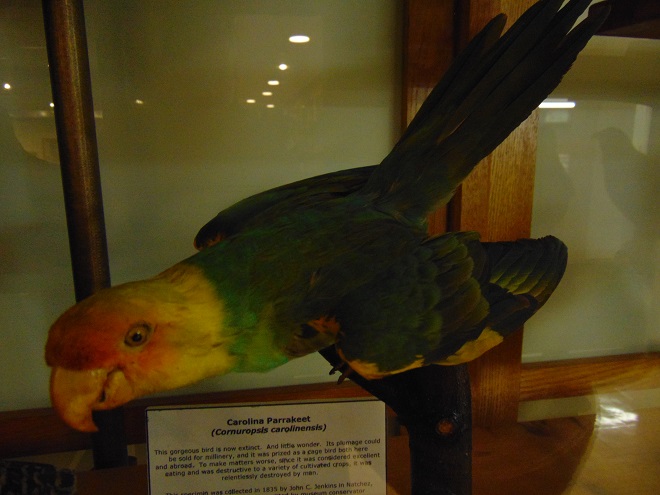
The Allegheny Woodrat (Neotoma magister), a threatened species in Pennsylvania and a critically imperiled species in Maryland, is a habitat specialist requiring the forested rocky slopes, talus-flanked ridgetops, and caves of the Ridge and Valley Province for its nest sites and survival. Isolated populations survived within similar environs in the lower Susquehanna River valley’s Piedmont Province and on South Mountain through at least the first half of the twentieth century, but have since been extirpated. Human encroachment that fragments their habitat and promotes exposure to parasite-hosting mammals including the Raccoon (Procyon lotor), carrier of the Raccoon Roundworm (Baylisascarius procyonis), could prove fatal to remaining populations of this native mammal. (National Park Service image by Rick Olsen)The American Oystercatcher (Haematopus palliatus) is a specialist species that uses its highly adapted bill to feed on marine invertebrates including mollusks, few of which are actually oysters. Reliant upon tidal ecosystems for its survival, many of the seashore animals that make up this wader’s diet are themselves specialist species. Oystercatchers spend nearly their entire lives in tidal marshes or within the intertidal zone on beaches. They also frequent rocky jetties, particularly during high tide. This individual was photographed near the mouth of Chesapeake Bay in Northhampton County, Virginia, a location that, when the waters of the Atlantic started rising over 10,000 years ago, was the lower Susquehanna valley about 60 miles from the river’s mouth at present-day Norfolk Canyon along the edge of the continental shelf. Get the drift?
As the autumn bird migration draws to a close for 2024, we’re delighted to be finding five of our favorite visitors from the coniferous and mixed forests of Canada and the northernmost continental United States.
Yellow-bellied Sapsuckers drill evenly spaced holes which they repeatedly visit to harvest “sap” and the insects that become trapped therein. These surgically small excavations penetrate only the bark and the phloem, a shallow, spongy layer of the trunk that carries sugars from the leaves to other parts of the tree. Seldom do they puncture the thin, underlying cambium layer which protects the true sapwood. After healing, sapsucker holes leave linear rows of small scars which are sometimes still discernible decades after a bird’s final visit. This adult male will probably linger in the Lower Susquehanna River Watershed until colder weather renders the tree totally dormant, the flow of “sap” ebbs, and small insects become harder to find. Then he’ll make his way off toward southern forests of oak and pine for the remainder of the winter. Sapsuckers work their way north as sugary “sap” begins flowing again in the spring.The Hermit Thrush is another denizen of coniferous and mixed forests. In habitats with dense cover and sufficient food sources like fruit-bearing shrubs and vines, some will remain through the winter. The Hermit Thrush is the only spot-breasted thrush regularly seen in our region from November through March.Almost the size of a thrush, the largest of our native sparrows, the Fox Sparrow, is currently at the peak of its southbound migration. While taking a break from their nocturnal flights, some may stray from forest edges to visit suburban feeding stations. Most leave our area by mid-December, then begin returning north as early as mid-February.Not present every year, flocks of Pine Siskins are beginning to arrive in the lower Susquehanna region. They are currently most common along the mountain tops of the Ridge and Valley Province where they are feeding on the seeds of the Sweet Birch, a tree also known as Black Birch. Look for them around niger seed feeders and on the prickly seed balls of cultivated American Sweetgum, but don’t be surprised if they quickly pass us by to spend the winter on the Atlantic Coastal Plain to our south where this native tree grows in abundance.Since late October, Purple Finches have been widespread throughout the region. These female/juvenile male types are frequently being seen at feeders, particularly near woodlands and other areas with stands of conifers.Less frequently seen are the adult male Purple Finches in their raspberry-colored plumage. What a dandy.
While right now is the best time to get out and look for these species from the northern forests, any or all of them could linger into the winter months, particularly where the food supply is sufficient and conifers and other evergreens provide cover from the blustery weather.
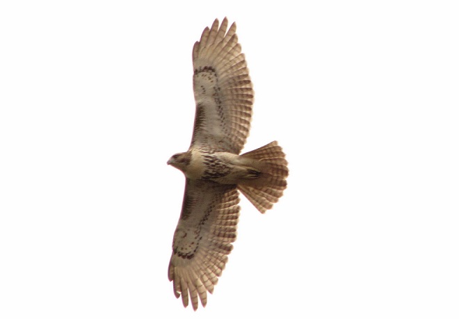
As we enter November, migratory raptor flights through the Lower Susquehanna River Watershed transition to the bigger birds. Whether you’re on the river, on a mountain, or just outside your humble abode, persistent alertness to soaring avians can yield rewarding views of a number of late-season specialties.
Red-tailed Hawks dominate the southbound raptor flights in November.Juvenile (hatch-year) Red-tailed Hawks are generally less wary and more inquisitive than the more experienced adult birds. Their curiosity frequently gets them into trouble, particularly when they try to hunt small rodents in traffic along busy roadways.Far fewer in number are migratory Red-shouldered Hawks. In our region, these denizens of bottomland forests more commonly migrate along the southern edge of the Piedmont and through the upper Atlantic Coastal Plain.A southbound hatch-year (juvenile) Red-shouldered Hawk.Mixed-race Peregrine Falcons, the descendants of birds reintroduced into the Mid-Atlantic States during the late twentieth century, often roam our region during the late-fall and winter months before settling into their nesting territories with the approach of spring. We spotted this one along a local ridge, but you may be more likely to see them in the city or near a bridge or dam on the river.As this adult peregrine passed the lookout, we noted its full crop. A sign it just completed a successful hunt.
A visit to a ridgetop on a breezy day—particularly after passage of a cold front—may give you the chance to see numerous eagles as well.
A second-year (Basic I) Bald Eagle barrel rolls while pursuing an adult Bald Eagle.
This afternoon, we got lucky and were treated to a bit of an aging clinic presented by the Bald Eagles we observed and photographed. Careful determination of the age classes of raptors counted by hawkwatchers can provide an early warning of problems in the ecosystems that support populations of these top-of-the-food-chain predators. For example: during the 1950s and early 1960s, a progressively lower percentage of juvenile and other non-adult age classes among the Bald Eagles being observed forewarned of the dangers of dichlorodiphenyltrichloroethane (DDT) pesticide in the environment. The principle effect of accumulations of the DDT toxins in eagles, Ospreys, Peregrine Falcons, and other predatory birds that consumed waterfowl and/or fish was to thin their eggs shells. The result was widespread brood failure and a near total loss of new generations of offspring. Eventually, nearly all Bald Eagles being seen in areas impacted by DDT were progressively older adults, most of which failed as nesting pairs. As the adult birds began dying off, the Bald Eagle population dwindled to numbers that raised fears of the species’ extinction. Implementation of the DDT cancellation order and the Clean Water Act in 1972, and the Endangered Species Act in 1973, helped save the Bald Eagle. But our regional “Eastern Peregrine Falcon”, a bird with a shorter life span than the Bald Eagle, was unable to endure the years of DDT use, dioxin pollution, and illegal hunting and egg collecting. Its population is gone.
A hatch-year (juvenile) Bald Eagle is typically dark headed and in a fresh set of juvenile flight feathers that exhibit no signs of molt. If the reproduction season and the months that followed were favorable for this year’s brood of new eagles, there should be nearly as many hatch-year birds as there are adults in an overall population.By November, second-year (Basic I) Bald Eagles are replacing many of their flight feathers and often show ragged trailing edges in the wings due to the retention of some of the well-worn and notably longer juvenile feathers. Varying amounts of white mottling are visible on the breast, belly, and underwing coverts. Due to mortality, there are usually fewer second-year Bald Eagles than there are hatch-year or adult birds.Another example of a second-year (Basic I) Bald Eagle.Third-year (Basic II) Bald Eagles show more yellow in the bill and an “osprey face”, a white head with a wide dark line through the eye. Most of the juvenile flight feathers have been replaced, so the wing edges appear more uniform. Like the second-year eagles, there is a varying amount of white in the breast, belly, and underwing coverts. In an overall population of eagles, birds in this age class are usually less common than those that are younger or those that are adults.Composite image of Bald Eagles in typical November plumage during their first three years. To see more images like this, be certain to click the “Hawkwatcher’s Helper: Identifying Bald Eagles and other Diurnal Raptors” tab at the top of this page.A fourth year (Basic III) Bald Eagle will often be seen with a black-bordered tail and a thin dark line through the eye. In some birds, traces of these traits can linger into the fifth year and beyond. These plumage types are usually the least frequently observed among an overall population of Bald Eagles. (Note: In these older birds, there develops significant variation in the timing of feather molt. In rare cases, fourth-year Bald Eagles may show minimal dark color in the tail or eye line and may appear to be in near definitive adult plumage.)A possible fifth-year (Basic IV) Bald Eagle.Adult Bald Eagles in definitive plumage. Birds in this plumage class are often the most frequently observed because the group includes all eagles five or six years of age and older.
While the Bald Eagles are still stealing the show, cold and gusty weather should bring an increasing number of Golden Eagles our way during the remainder of the month. Some are already trickling through…
This “before-third-year” Golden Eagle shows no visible signs of molt in its juvenile (hatch-year) plumage, but a look at the upperwing coverts is needed to properly age the bird. To learn more about the molt sequence in Golden Eagles, be sure to click the “Golden Eagle Aging Chart” tab at the top of this page.A “before-third-year” Golden Eagle (top) passing the lookout along with a second-year Bald Eagle (bottom).Another “before-third-year” Golden Eagle. More are on the way!
Later this month, Bald Eagle numbers on the lower Susquehanna below Conowingo Dam (U.S. 1) near Rising Sun, Maryland, will begin to grow. Fisherman’s Park, located along the west shoreline below the dam, is an excellent place to observe and photograph scores of these regal birds. And few places provide a better opportunity to learn to differentiate Bald Eagle age classes. If you’re really lucky, a Golden Eagle or two may drop in as well. So plan to make the trip. The best time to visit is on a weekday. The parking lot can become overcrowded on weekends and will be closed under such circumstances. It’s best to avoid the long Thanksgiving weekend as well.
For many species of terrestrial vertebrates living in the lower Susquehanna valley, it’s time to take refuge in a safe place below ground to enter a winter-long slumber. The numerous frosty nights of the past two weeks have expedited the stragglers’ efforts to find a suitable place to pass our coldest months.
Aside from the Eastern Box Turtle (Terrapene carolina carolina), the Wood Turtle (Glyptemys insculpta) is our most terrestrial species of testudine, however it is seldom found far from wet bottomlands. Last week, we found this pair preparing to burrow into alluvial soils along the edge of a floodplain wetland where they will spend the winter. In recent years, Wood Turtle numbers have plummeted due to habitat fragmentation and loss, and due to collecting by short-sighted petkeepers and profiteers.A sluggish Wood Turtle catching a few last rays of sunshine before digging in for the winter. If you encounter these or any turtles now or at any time of year, it’s important that they not be disturbed. Look and leave them be.
And now, just in time for Halloween, a look at some hibernating species that some of our more squeamish readers consider to be “scary”.
In the mountainous forests of the Ridge and Valley Province, there lives a seldom seen little mouse which, unlike the more familiar species found in the fields, farms, and homes of our valleys and Piedmont, spends almost half the year in true hibernation.
The Woodland Jumping Mouse (Napaeozapus insignis) is a nocturnal species of rodent found primarily on rocky forest slopes, particularly those with growths of Eastern White Pine and Eastern Hemlock. Unlike the similar White-footed Mouse, a species that sometimes enters homes in the fall and remains active year-round, the Woodland Jumping Mouse builds a small subterranean nest among rocks and boulders where it will enter a long winter slumber, often not emerging until the milder days of April. During the long hibernation, these mice sometimes fatally diminish the energy stored in their body fat; up to 75% may perish before spring arrives (Merritt, 1987).
In spring and fall, Eastern (Black) Ratsnakes are frequently seen basking in the sun as they absorb heat and get their metabolism going. During the hottest days of summer, when ambient air temperature is sufficient for their needs, they become nocturnal, hunting mice and other creatures that are also active at night. During October, they make their way back to a winter den where they will remain until March or April.
A last-minute Eastern (Black) Ratsnake makes a slow late-October trek across a mountain road toward a winter den on the south slope of the ridge.This Eastern Ratsnake is on its way to a cold-season hideout where it may spend the darker months in the company of other communal hibernators including……Eastern Copperheads……and Timber Rattlesnakes.
That’s right, all three of these snakes are known to cohabitate, not just during hibernation, but at other times of the year as well. And you thought they were mean and nasty to anything and everything in their path, didn’t you?
Here in the northeastern United States, fear of indigenous wild snakes is a totally irrational anxiety. It’s a figment of our indoctrination. Their wicked reputation is almost exclusively the result of a never-ending stream of demonizing propaganda from the pulpit, press, parents, panicked, and picture shows. All they want from you and I is to be left alone. Want something to really be afraid of this Halloween? Try domestic dogs. That’s right—the “friendly” pooch. In the United States, they’ll land hundreds of people in the emergency room today. Don’t like that one. How ’bout cars and trucks. They’ll kill and maim people all day long. And don’t forget about sugar. Yes friends, that sweet treat is pure poison that kills all day long. Happy Halloween!
SOURCES
Merritt, Joseph F. 1987. Guide to the Mammals of Pennsylvania. University of Pittsburgh Press. Pittsburgh, PA. pp.230-233.
Shaffer, Larry L. 1991. Pennsylvania Amphibians and Reptiles. Pennsylvania Fish Commission. Harrisburg, PA.
For the past several weeks, we’ve given you a look at the fallout of Neotropical songbirds on mornings following significant nocturnal flights of southbound migrants. Now let’s examine the diurnal (daytime) flights that have developed in recent days over parts of the lower Susquehanna basin and adjacent regions.
For those observing diurnal migrants, particularly at raptor-counting stations, the third week of September is prime time for large flights of tropics-bound Broad-winged Hawks. Winds from easterly directions during this year’s movements kept the greatest concentrations of these birds in the Ridge and Valley Province and upper areas of the Piedmont as they transited our region along a southwesterly heading. Counts topped 1,000 birds or more on at least one day at each of these lookouts during the past seven days. Meanwhile at hawk watches along the Piedmont/Atlantic Coastal Plain border, where flights topped 10,000 or more birds on the best days last fall, observers struggled to see 100 Broad-winged Hawks in a single day.
Dozens of migrating Broad-winged Hawks during a morning liftoff to the north of Blue Mountain.
Among the challenges counters faced while enumerating migratory Broad-winged Hawks this week was the often clear blue skies, a glaring sun, and the high altitude at which these raptors fly during the mid-day hours.
Large numbers of Broad-winged Hawks climbing on a thermal updraft to gain altitude can become increasingly difficult to spot in a clear blue sky.Higher and higher they go until they practically disappear from view.Cloud cover can help make locating really high-flying birds a bit easier, but they can sometimes climb into the lower portion of the cloud and vanish.
Another factor complicating the hawk counters’ tasks this week, particularly west of the Susquehanna River, was the widespread presence of another group of diurnal fliers.
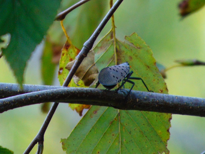
Was it the migratory Blue Jays that are beginning to move through the area? No.Was it the increasing numbers of Sharp-shinned Hawks and other raptors? No.So what was it that complicated the hawkwatchers’ efforts to find high-flying Broad-winged Hawks during this week’s flights?Is it a bird? Is it a plane? No. And it’s nobody’s superhero either. It’s the non-native Spotted Lanternfly and it is now very numerous west of the Susquehanna and common enough to the east to make even experienced observers take a second look while scanning the skies for Broad-winged Hawks and other migrating raptors. Just how many do raptor counters have to contend with? Even where these invasive insects have become less populous in the lower Susquehanna valley, hundreds still fill the skies above forest clearings around hawk-counting stations including Waggoner’s Gap, Second Mountain, and Rocky Ridge County Park.Spotted Lanternfly populations explode with great vigor as they colonize areas with plenty of tender new growth on native, non-native, and cultivated shrubs, trees, and vines. Earlier this week, National Weather Service Doppler Radar in Pittsburgh, Pennsylvania, captured enormous mid-afternoon flights of Spotted Lanternflies in recently invaded areas of southwestern Pennsylvania and eastern Ohio. (NOAA/National Weather Service Doppler Radar image)A base velocity image consisting primarily of Spotted Lanternflies in southwestern Pennsylvania and eastern Ohio. (NOAA/National Weather Service Doppler Radar image)
As the Broad-winged Hawk migration draws to a close during the coming ten days, the occurrence of the one dozen other migratory diurnal raptors will be on the upswing. They generally fly at lower altitudes, often relying upon wind updrafts on the ridges for lift instead of high-rising thermal updrafts. They therefore present better observation opportunities for visitors at hawk watch lookouts and are less frequently confused with high-flying Spotted Lanternflies.
A Merlin seen earlier this week migrating through the Lower Susquehanna River Watershed. The numbers of migrating Merlins and other falcons will peak sometime in coming weeks.
The deluge of rain that soaked the lower Susquehanna watershed during last week is now just a memory. Streams to the west of the river, where the flooding courtesy of the remnants of Hurricane Debby was most severe, have reached their crest and receded. Sliding away toward the Chesapeake and Atlantic is all that runoff, laden with a brew of pollutants including but not limited to: agricultural nutrients, sediment, petroleum products, sewage, lawn chemicals, tires, dog poop, and all that litter—paper, plastics, glass, Styrofoam, and more. For aquatic organisms including our freshwater fish, these floods, particularly when they occur in summer, can compound the effects of the numerous stressors that already limit their ability to live, thrive, and reproduce.
(Environmental Protection Agency image)
One of those preexisting stressors, high water temperature, can be either intensified or relieved by summertime precipitation. Runoff from forested or other densely vegetated ground normally has little impact on stream temperature. But segments of waterways receiving significant volumes of runoff from areas of sun-exposed impervious ground will usually see increases during at least the early stages of a rain event. Fortunately, projects implemented to address the negative impacts of stormwater flow and stream impairment can often have the additional benefit of helping to attenuate sudden rises in stream temperature.
While a row of trees along a creek can help provide protection from the thermal impact of the sun, a vegetative riparian buffer must be much wider to be effective for absorbing, cooling, and treating runoff from fields, lawns, and paved surfaces. This buffer is too narrow to prevent surface runoff from polluting the water.
Of the fishes inhabiting the Lower Susquehanna River Watershed’s temperate streams, the least tolerant of summer warming are the trouts and sculpins—species often described as “coldwater fishes”. Coldwater fishes require water temperatures below 70° Fahrenheit to thrive and reproduce. The optimal temperature range is 50° to 65° F. In the lower Susquehanna valley, few streams are able to sustain trouts and sculpins through the summer months—largely due to the effects of warm stormwater runoff and other forms of impairment.
Sculpins, including the Blue Ridge Sculpin (Cottus caeruleomentum) seen here, are native coldwater fishes which, during the 11,000 years since the last glacial maximum, have had the availability of their favored habitat sharply reduced by warming water temperatures and a rising Atlantic. During this interval, seawater has inundated the path of the “Late” Pleistocene lower Susquehanna which passed through the section of flooded river watershed we now call Chesapeake Bay and continued across the continental shelf to what was, during the glacial maximum, the river’s mouth at Norfolk Canyon. Today, cut off from neighboring drainage basins, sculpins survive exclusively in cold headwaters, and only in those where human alterations including pollution, dams, channelization, and reduced base flow haven’t yet eliminated their isolated populations. Formerly believed to be composed of two widespread North American species, the Slimy Sculpin (Cottus cognatus) and the Mottled Sculpin (Cottus bairdii), study in recent decades is discovering that sculpin populations in the present-day lower Susquehanna and neighboring Potomac headwaters consist of at least three newly delineated species: Blue Ridge Sculpin, Potomac Sculpin (Cottus gerardi), and Checkered Sculpin (Cottus sp.), the latter an as yet undescribed species found only in the refugium of limestone springs in the Potomac drainage in West Virginia; Frederick and Washington Counties, Maryland; and Franklin County, Pennsylvania. (United States Geological Survey image)Stare at this for a little while, you’ll figure it out…………More than 11,000 years ago, during the end of the last glacial period, when sea level was about 275 feet lower than it is today, there was no Chesapeake Bay, just a great Susquehanna River that flowed to the edge of the continental shelf and its mouth at Norfolk Canyon. It was a river draining taiga forests of pine, spruce , and fir, and it carried along the waters of all the present-day bay’s tributaries and more. The section of the river’s watershed we presently call the lower Susquehanna was, at the time, the upper Susquehanna watershed. Brook Trout and sculpins had the run of the river and its tributaries back then. And the entire watershed was a coldwater fishery, with limestone and other groundwater springs providing not refuge from summer heat, but a place to escape freezing water. (United States Geological Survey base image)Norfolk Canyon, the mouth of the Susquehanna River during the most recent glacial maximum, now lies more than 275 feet below the surface of the ocean and plunges to more than a mile in depth along the finger of out wash from the gorge. (United States Geological Survey image)Tens of thousands of trout are raised in state-operated and cooperative nurseries for stocking throughout the lower Susquehanna valley. These rearing facilities are located on spring-fed headwaters with sufficient flow to assure cold temperatures year round. While the Rainbow Trout and Brown Trout (Salmo trutta) are the most commonly stocked species, the Brook Trout (Salvelinus fontinalis) is the only one native to American waters. It is the least tolerant of stream warming and still reproduces in the wild only in a few pristine headwaters streams in the region. During spring, all three of these species have been observed on rare occasions entering the fish lift facilities at the hydroelectric dams on the river, presumably returning to the Susquehanna as sea-run trout.
Coldwater fishes are generally found in small spring-fed creeks and headwaters runs. Where stream gradient, substrate, dissolved oxygen, and other parameters are favorable, some species may be tolerant of water warmer than the optimal values. In other words, these temperature classifications are not set in stone and nobody ever explained ichthyology to a fish, so there are exceptions. The Brown Trout for example is sometimes listed as a “coldwater transition fish”, able to survive and reproduce in waters where stream quality is exceptionally good but the temperature may periodically reach the mid-seventies.
The Eastern Blacknose Dace is sometimes classified as a “coldwater transition fish”. It can be found in headwaters runs as well as in creeks with good water quality.The Longnose Dace is another “coldwater transition fish” known only from clear, clean, flowing waters.
More tolerant of summer heat than the trouts, sculpins, and daces are the “coolwater fishes”—species able to feed, grow, and reproduce in streams with a temperature of less than 80° F, but higher than 60° F. Coolwater fishes thrive in creeks and rivers that hover in the 65° to 70° F range during summer.
The Creek Chub is a familiar species of “coolwater fish” seldom found remaining in waters exceeding 80 degrees Fahrenheit.The Yellow Perch (Perca flavescens) was perhaps the most frequently targeted coolwater “gamefish” in the Lower Susquehanna River Watershed prior to the introduction of the Northern Pike (Esox lucius) and Muskellunge (Esox masquinongy). Today’s prevalence of warmwater streams and the dozens of species of non-native predatory fishes now naturalized within them have left the Yellow Perch populations greatly reduced and all but forgotten by anglers. Out of sight, out of mind. (National Park Service image)
What are the causes of modern-day reductions in coldwater and coolwater fish habitats in the lower Susquehanna River and its hundreds of miles of tributaries? To answer that, let’s take a look at the atmospheric, cosmic, and hydrologic processes that impact water temperature. Technically, these processes could be measured as heat flux—the rate of heat energy transfer per unit area per unit time, frequently expressed as watts per meter squared (W/m²). Without getting too technical, we’ll just take a look at the practical impact these processes have on stream temperatures.
HEAT FLUX PROCESSES IN A SEGMENT OF STREAM
Heat Flux Processes on Stream and River Segments. These processes could be measured as heat flux—the rate of heat energy transfer per unit area per unit time. (Environmental Protection Agency image)
INCOMING TEMPERATURE AND FLOW—The baseline temperature of stream water entering a given segment of waterway is obviously the chief factor determining its temperature when exiting that segment. Incoming temperature and flow also determine the water’s susceptibility to heat absorption or loss while transiting the segment. Lower flows may subject the given volume of water to a greater loss or gain of heat energy during the time needed to pass through the segment than the same volume at a higher flow. Lower flows may also reduce stream velocity and extend a given volume of water’s exposure time to the exchange of heat energy while moving through the segment. Generally speaking…
…the higher the stream flow, the less a given volume of that stream’s water may be impacted by the effects of the heat flux processes within the segment.
…the lower the stream flow, the more a given volume of that stream’s water may be impacted by the effects of the heat flux processes within that segment.
…the temperature and flow rate of precipitation entering the segment are factors that determine the impact of its heat energy transfer to or from a given volume of the stream’s waters.
…the temperature and flow rate of runoff and point-source discharges entering the segment are factors that determine the impact of their heat energy transfer to or from a given volume of the stream’s waters.
Stormwater from impervious surfaces including roads, parking lots, roofs, and lawns quickly impacts temperatures in small creeks. Channelized streams are availed few of the positive attributes provided by many of the heat flux processes we’re about to see. They therefore suffer from severe impairment and are exposed to temperature extremes that few aquatic organisms can survive. Runoff from sun-heated pavement during a summer thunderstorm can often exceed 100 degrees Fahrenheit and can, at sufficient flow rate, quickly raise the temperature of a small stream to well over 90 degrees.Stormwater runoff not only poses a thermal threat to waterways, its a significant source of a wide variety of pollutants.
GROUNDWATER INPUT—In streams connected to the aquifer, the temperature in a flowing segment can be impacted by the influx of cold groundwater. With temperatures ranging from about 52° to 60° Fahrenheit, groundwater will absorb heat from the stream in summer, and warm it in the winter. In warmwater streams, coldwater and coolwater fishes will often seek areas of the substrate where groundwater is entering for use as refugium from the summer heat. Yellow Perch in the lower Susquehanna are known to exhibit this behavior.
Creeks and rivers connected to the aquifer and receiving supplemental flow from it are known as “gaining streams”. These streams frequently feed water into the aquifer as well. (United States Geological Survey image)When flowing through an area experiencing drought or an excessive removal of groundwater (lots of wells, etc.), a waterway can become a “losing stream”, one that surrenders a portion of its flow to recharge the aquifer. Further downstream, the reduced flow can make such a creek or river more susceptible to the effects of heat flux processes. (United States Geological Survey image)Seriously depleted aquifers can lead to a “disconnected stream”. Smaller waterways subjected to these conditions will sometimes lose all their flow to the ground, often causing a catastrophic failure of the aquatic ecosystem supported therein. (United States Geological Survey image)Urban runoff overwhelms this small stream with polluted water than can reach temperatures of 100 degrees or more (left), then lets it high and dry with no baseflow during periods of dry weather (right) as the waterway becomes disconnected from the much-depleted aquifer.Well-designed and properly constructed stormwater retention basins not only recharge groundwater supplies for wells and streams, they can also help prevent thermal pollution in waterways. Planted with native wetland species and allowed to thrive, they can become treasured wildlife islands in otherwise inhospitable environs. The benefits don’t stop there; plants also help sequester nutrients contained in the runoff.
HYPORHEIC EXCHANGE—Related to groundwater input, hyporheic exchange is the slow movement of water through the rock, sand, gravel, and soils composing the streambed, saturated shoreline, shallow aquifer, and connected floodplain of a creek or river. As a heat flux process, hyporheic exchange helps moderate extremes in seasonal water temperatures by conducting energy between the solid materials in the zone and the flowing water. Hyporheic zones are important habitats for many species of aquatic invertebrates and spawning fish. Natural chemical processes within these zones convert ammonia-producing wastes into nitrite, then nitrate, allowing it to be absorbed as food by plants growing in the stream or in the alluvium within the zone. Vegetation removal, channelization, legacy sediments, silt deposits, and man-made walls and dams can negate the benefits of hyporheic exchange.
Exchange of surface and ground water within the hyporheic zone is most directly associated with high-gradient (left) and meandering (right) segments of streams. (United States Geological Survey image)Very common on streams in the lower Susquehanna valley are these accumulations of legacy sediments at the sites of former mill ponds. After the dams were removed, the creeks began eroding their way down through the mire as they tried to reestablish their floodplains and find their native substrate. These trapped waterways are not only cut off from their hyporheic zones, they’re now a major source of nutrient and sediment pollution. Misguided landowners like this one frequently dump fill into these sites to “save their land” and “control flooding”. The fill and materials added to “shore up the banks” do nothing to fix what ails the creek, but instead displace more water to make the impact of flooding even more widespread.Rehabilitation projects that remove legacy sediments help restore hyporheic exchange by reconnecting the stream to its underlying geology, its floodplain, and its wetlands. Rising waters remain in the floodplain where they get a good bio-scrubbing and help replenish the creek and groundwater supply. As the experts say, “floodplains are for flooding.”
ATMOSPHERIC EXCHANGE (CONVECTION, EVAPORATION)—Primarily a process by which a stream loses heat energy and cools its waters, atmospheric exchange is also a means by which a warm air mass can relinquish heat to cooler waters and thus increase their temperature. This phenomenon can be dramatically enhanced when a stream passes through a so-called urban heat island where air temperatures remain warm through the night. Convection, the movement of heat energy through a fluid (liquid or gas), causes warmer, less-dense water to rise to the surface of a stream, particularly where there is minimal turbulence. When the air above is cooler than the water’s surface layer, the stream will conduct heat energy across the water/atmosphere interface causing the warmed air molecules to rise in a convection column. If the atmospheric relative humidity is less than 100%, some surface water will vaporize—a process that expends more of the stream’s heat energy. The rate of convective and evaporative cooling in a given stream segment is directly related to the degree of difference between the water temperature and air temperature, and to the relative humidity in the air mass above the lake, creek, or river. The mechanical action of stream turbulence including rapids, riffles, and falls increases the contact area between air and water to maximize the atmospheric exchange of heat energy. The convective air current we call surface wind has a turbulent wave-producing effect on water that can also maximize atmospheric exchange; think of a cold autumn wind robbing heat energy from a warm lake or river or a hot summer wind imparting its heat to a cooler creek. These exchanges are both conductive in nature (air-to-water/water-to-air) and evaporative, the latter being expedited by the movement of dry air over warm water.
Usually classified as one of the coolwater fishes, the bottom-dwelling Tessellated Darter can thrive in the warmer creeks and in the main stem of the Susquehanna by inhabiting riffles where atmospheric exchange in the form of increased evaporation helps reduce temperatures and convective currents carry the cooler, well-oxygenated water to the streambed.Humans utilize the concept of atmospheric exchange, adopting the phenomena of evaporation and convection to cool the hot waters produced during electric generation and other industrial processes before discharge into a lake or river.
STREAMBED CONDUCTIVE EXCHANGE—In the lower Susquehanna watershed, there may be no better natural example of streambed conductive exchange than the Triassic-Jurassic diabase pothole bedrocks of Conewago Falls on the river at the south end of Three Mile Island.
During sunny days, the massive diabase pothole rocks at Conewago Falls absorb solar (shortwave) radiation, then conduct that heat energy into the flowing water, often continuing to pass the accumulated warmth into the river during the night. On cloudy days, the riverbed collects longwave atmospheric radiation, a heat flux process that yields significantly less energy for conduction into the rapids, riffles, and pools of the falls. During periods of low river flow, the heating effect of streambed conductive exchange can become magnified. Compared to conditions that prevail when torrents of turbid water are rushing through the falls, partially exposed bedrock surrounded by clear water collects radiated energy much more efficiently, then conducts the heat to a greatly reduced volume of passing water. During summer and autumn, this process can create a mix of temperature zones within the falls with warmer water lingering in slow-moving pools and cooler water flowing in the deeper fast-moving channels. Along the falls’ mile-long course, a haven is created for aquatic organisms including warmwater and some coolwater fishes, oft times attracting anglers and a variety of hungry migrating birds as well.Classified as one of our coolwater fishes, the Fallfish finds favorable conditions for feeding, growing, and spawning in the well-oxygenated waters of Conewago Falls.Though the lower Susquehanna River is classified as a warmwater fishery, the Northern Hog Sucker (Hypentelium nigricans), another of our native coolwater fishes, finds the fast-moving waters of Conewago Falls to its liking. Northern Hog Suckers are known to inhabit streams cold enough to host trout. They exhibit remarkable home range fidelity, sometimes spending their entire lives occupying the same several hundred feet of waterway. Northern Hog Suckers are often designated an indicator of good water quality, intolerant of many stream impairment parameters. Their presence in Conewago Falls provides testament to the quality of the warmwater fishery there.An unnatural example. The reduced base flow in this channelized and severely impaired creek has been rendered vulnerable to the negative impacts of several heat flux processes including streambed conductive exchange. Urban stormwater/surfacewater inflow, solar (shortwave) radiation, and heat conducted into the stream from the masonry walls, curbs, and raceway can all conspire to cook aquatic organisms with life-quenching summer water temperatures exceeding 90 degrees Fahrenheit.
SOLAR (SHORTWAVE) RADIATION—The sun provides the energy that fuels the earth’s complex climate. The primary heat flux process that heats our planet is the absorption of solar radiation in the shortwave spectrum, which includes ultraviolet, visible, and infrared frequencies at the upper end of the longwave spectrum. Streams and other bodies of water absorb the greatest amounts of solar (shortwave) radiation during the weeks around summer solstice when the sun at mid-day is closer to zenith than at any other time of the year. However, the heating impact of the radiation may be greatest when the volume of water in the creek, river, or lake is at its minimum for the year—often during early fall.
The rate, measured in watts per square meter, at which solar (shortwave) energy is directly radiated to a given area on the earth’s surface (including streams and other waters) is determined by: solar activity, the angle of the sun in the sky, aspect (slope) of the receiving surface, the opacity of the overlying atmosphere, and the distance of the earth from the sun. The former varies with the year’s seasons, the time of day, and the latitude of a given area. The latter is currently at its annual minimum when earth is at perihelion during the early days of January, thus providing the northern hemisphere with a little bump in radiation during the shortest days of the year when the sun is at its lowest angle in the sky. (NASA image)A varying portion of the solar (shortwave) radiation reaching the earth is reflected back into space by clouds. A smaller share is absorbed by the atmosphere, thus heating it. An even lesser quantity is reflected back into space by water and land. The remainder of the energy is absorbed by the planet’s surfaces, its water and land. (NASA image)
INCIDENT SHORTWAVE RADIATION—Also known as insolation (incoming solar radiation), incident shortwave radiation is the sum total energy of both the direct solar radiation that travels to the earth’s surface unaffected by the atmosphere and the diffuse radiation, waves that have been weakened and scattered by constituents of the atmosphere before reaching the planet’s surface. On a cloudy day, the warming of terrestrial surfaces including streams and other bodies of water is the result of diffuse radiation. On days with any amount of sunshine at all, both direct and diffuse radiation heat our waters and lands.
Warmwater fishes such as the native Pumpkinseed (Lepomis gibbosus) thrive in sun-drenched 70-to-85-degree waters as long as other heat flux processes prevent sudden temperature increases and oxygen depletion.Mowed stream banks offer a waterway no protection from incoming solar (shortwave) radiation, nor terrestrial forms of impairment including nutrient-rich stormwater runoff and silt.
REFLECTED SHORTWAVE RADIATION—known as albedo, reflected solar (shortwave) radiation is energy directed away from the earth’s surface before being absorbed. A surface’s albedo value is basically determined by its color, black having little reflective value, white and silvery surfaces reflecting nearly all solar (shortwave) radiation away. A surface with no reflective properties has an albedo value of 0, while a totally reflective surface has a value of 1. Clean snow with a value of about 0.85 to 0.9 (85% to 90%) is a highly reflective surface; yellow snow isn’t as good. A stream, river, or lake blanketed with ice and snow will absorb very little solar energy and will rely upon other heat flux processes to trigger a melt and thaw. The surface of open water has a varying albedo value determined mostly by the angle of the sun. Solar radiation striking the water’s surface at a low angle is mostly reflected away, while that originating at an angle closer to zenith is more readily absorbed.
To avoid the heating effects of solar (shortwave) and atmospheric longwave radiation, coldwater and coolwater fishes require streams offering protection from full exposure to direct sunlight and cloud cover. Runs and creeks flowing beneath a closed canopy of forest trees are shielded from 25% or more of incoming radiation and are thus able to better maintain thermal stability during the most vulnerable period of the year for temperature-sensitive fishes, May through October.
LONGWAVE RADIATION—Radiation in the longwave spectrum is composed of infrared waves at frequencies lower than those of the shortwave spectrum. Longwave radiation, sometimes just called infrared radiation, is produced by the earth and its atmosphere and is propagated in all directions, day and night. It warms mostly the lower atmosphere which in turn warms the earth’s surface including its waters. Some longwave energy can even be radiated into the waterway from its own streambed—and the stream can return the favor. Other forms of mass surrounding a stream such as a rocky shoreline or a man-made structure such as bridge pier can trade longwave radiation with a waterway. The effect of these latter exchanges is largely trivial and never rivals the heat flux transfer of warm to cold provided by conduction.
Longwave radiation emissions slow as the temperature of the emitting mass decreases, just as they also increase with temperature of the mass. Longwave radiation emissions therefore decrease with altitude along with the temperature of the water vapor, carbon dioxide, methane, and other gases that produce them. As such, the highest reaches of the atmosphere have a greatly reduced capability of shedding longwave radiation into space. At ground level, lakes, creeks, and streams receive their greatest dose of longwave radiation while beneath the cover of low-lying clouds or fog. (NASA image)
CANOPY RADIATION—Trees emit longwave radiation that may have a limited heat flux impact on waterway temperature. This radiation is diffuse, of scattered effect, and scarcely detectable, particularly beneath multilayered dense canopies. Some of the infrared energy transmitted by the tree canopy is radiated skyward as well.
WATER RADIATION—Water, like all earthly matter composed of vibrating molecules, emits longwave radiation. This heat flux process provides an ongoing cooling effect to streams, rivers, lakes, and oceans—warmer ones shedding infrared energy at a faster rate than those that are cold.
Now that we have a basic understanding of the heat flux processes responsible for determining the water temperatures of our creeks and rivers, let’s venture a look at a few graphics from gauge stations on some of the lower Susquehanna’s tributaries equipped with appropriate United States Geological Survey monitoring devices. While the data from each of these stations is clearly noted to be provisional, it can still be used to generate comparative graphics showing basic trends in easy-to-monitor parameters like temperature and stream flow.
Each image is self-labeled and plots stream temperature in degrees Fahrenheit (bold blue) and stream discharge in cubic feet per second (thin blue).
The West Conewago Creek drains much of the Gettysburg Basin’s Triassic redbeds in Adams and northern York Counties in Pennsylvania and includes a small headwaters area in northern Maryland. The gauge station is located just a over a mile upstream from the waterway’s mouth on the Susquehanna just below Conewago Falls. Right through the summer heatwave, this 90-day graph shows a consistent daily pattern of daytime rises in temperature and nighttime cooling. To the right, a rapid cool down can be seen coinciding with two periods of high water, the first from a series of heavy thundershowers, the second from flooding caused by the remnants of Hurricane Debby. Notice that the early August downpours were so heavy that they cooled the hot surface runoff and waterway quickly, without creating a rise in stream temperature at the gauging station. Had this monitoring device been located on a small tributary in an area with an abundance of impervious surfaces, there would probably have been a brief rise in stream temperature prior to the cooldown. (United States Geological Survey image)
The daily oscillations in temperature reflect the influence of several heat flux processes. During the day, solar (shortwave) radiation and convection from summer air, especially those hot south winds, are largely responsible for the daily rises of about 5° F. Longwave radiation has a round-the-clock influence—adding heat to the stream during the day and mostly shedding it at night. Atmospheric exchange including evaporative cooling may help moderate the rise in stream temperatures during the day, and certainly plays a role in bringing them back down after sunset. Along its course this summer, the West Conewago Creek absorbed enough heat to render it a warmwater fishery in the area of the gauging station. The West Conewago is a shallow, low gradient stream over almost its entire course. Its waters move very slowly, thus extending their exposure time to radiated heat flux and reducing the benefit of cooling by atmospheric exchange. Fortunately for bass, catfish, and sunfish, these temperatures are in the ideal range for warmwater fishes to feed, grow, and reproduce—generally over 80° F, and ideally in the 70° to 85° F range. Coolwater fishes though, would not find this stream segment favorable. It was consistently above the 80° F maximum and the 60° to 70° F range preferred by these species. And coldwater fishes, well, they wouldn’t be caught dead in this stream segment. Wait, scratch that—the only way they would be caught in this segment is dead. No trouts or sculpins here.
The Codorus Creek drains primarily the carbonate valleys of York County to the south of the West Conewago watershed. This gauge station is located about a mile upstream from the creek’s mouth on the Susquehanna just below Haldeman Riffles. The graphic pattern is very similar to that of the West Conewago’s: daily heating and cooling cycles and a noticeable drop in stream temperature in early August caused by a day of thundershowers followed by the remnants of Hurricane Debby. (United States Geological Survey image)
Look closely and you’ll notice that although the temperature pattern on this chart closely resembles that of the West Conewago’s, the readings average about 5 degrees cooler. This may seem surprising when one realizes that the Codorus follows a channelized path through the heart of York City and its urbanized suburbs—a heat island of significance to a stream this size. Before that it passes through numerous impoundments where its waters are exposed to the full energy of the sun. The tempering factor for the Codorus is its baseflow. Despite draining a smaller watershed than its neighbor to the north, the Codorus’s baseflow (low flow between periods of rain) was 96 cubic feet per second on August 5th, nearly twice that of the West Conewago (51.1 cubic feet per second on August 5th). Thus, the incoming heat energy was distributed over a greater mass in the Codorus and had a reduced impact on its temperature. Though the Codorus is certainly a warmwater fishery in its lower reaches, coolwater and transitional fishes could probably inhabit its tributaries in segments located closer to groundwater sources without stress. Several streams in its upper reaches are in fact classified as trout-stocked fisheries.
This is a zoomed-in look at the previous graph showing the impact of a rainfall event on the water temperatures in Codorus Creek. Unlike the sharp declines accompanying the deluge of flood waters during the two events in early August, these lesser storms in late June generated just enough runoff to capture heat energy from impervious surfaces and warm the creek, temporarily breaking the daily heating/cooling cycle. Upstream in the immediate area of the runoff, the impact on the stream and/or its tributaries was probably much more dramatic, certainly raising temperatures into the nineties or above. (United States Geological Survey image)Kreutz Creek drains a carbonate bedrock area of York County and flows parallel to the Lincoln Highway (US 30) to enter the Susquehanna at Wrightsville. The gauging station is about one mile upstream from the creek’s mouth. (United States Geological Survey image)
The Kreutz Creek gauge shows temperature patterns similar to those in the West Conewago and Codorus data sets, but notice the lower overall temperature trend and the flow. Kreutz Creek is a much smaller stream than the other two, with a flow averaging less than one tenth that of the West Conewago and about one twentieth of that in the Codorus. And most of the watershed is cropland or urban/suburban space. Yet, the stream remains below 80° F through most of the summer. The saving graces in Kreutz Creek are reduced exposure time and gradient. The waters of Kreutz Creek tumble their way through a small watershed to enter the Susquehanna within twenty-four hours, barely time to go through a single daily heating and cooling cycle. As a result, their is no chance for water to accumulate radiant and convective heat over multiple summer days. The daily oscillations in temperature are less amplified than we find in the previous streams—a swing of about three degrees compared to five. This indicates a better balance between heat flux processes that raise temperature and those that reduce it. Atmospheric exchange in the stream’s riffles, forest cover, and good hyporheic exchange along its course could all be tempering factors in Kreutz Creek. From a temperature perspective, Kreutz Creek provides suitable waters for coolwater fishes.
Muddy Creek drains portions of southern York County through rolling farmland and woodlots. There are no large impoundments or widespread urban impacts in the watershed, which may help explain its slightly lower temperature trends. (United States Geological Survey image)
Muddy Creek is a trout-stocked fishery, but it cannot sustain coldwater species through the summer heat. Though temperatures in Muddy Creek may be suitable for coolwater fishes, silt, nutrients, low dissolved oxygen, and other factors could easily render it strictly a warmwater fishery, inhabited by species tolerant of significant stream impairment.
Chiques Creek drains mostly limestone farmland in northwestern Lancaster County. The gauging station is located near the stream’s mouth on the Susquehanna at Chiques (Chickies) Rock. Oscillations in temperature again resemble the other waterways, but daily highs remain almost entirely below 80 degrees. (United States Geological Survey image)
A significant number of stream segments in the Chiques watershed have been rehabilitated to eliminate intrusion by grazing livestock, cropland runoff, and other sources of impairment. Through partnerships between a local group of watershed volunteers and landowners, one tributary, Donegal Creek, has seen riparian buffers, exclusion fencing, and other water quality and habitat improvements installed along nearly ever inch of its run from Donegal Springs through high-intensity farmland to its mouth on the main stem of the Chiques just above its confluence with the Susquehanna. The improved water quality parameters in the Donegal support native coldwater sculpins and an introduced population of reproducing Brown Trout. While coldwater habitat is limited to the Donegal, the main stem of the Chiques and its largest tributary, the Little Chiques Creek, both provide suitable temperatures for coolwater fishes.
Streams in the Chiques Creek and similar limestone watersheds often pass through areas with significant bedrock formations. Heat flux processes including groundwater input, hyporheic exchange, and streambed conductive exchange can have a greater influence on water temperature along these segments.A breeding condition Eastern Balcknose Dace, one of the coldwater transition fishes found in the Chiques and its tributaries.The Common Shiner (Luxilus cornutus), a fish tolerant of warmwater streams, prefers cool, clear waters for spawning. For protection from late-spring and summer heat, breeding males may seek a section of creek with a streambed inflow of limestone groundwater to defend as their nesting territory.A closeup of the Chiques Creek graph showing what appears to be a little bump in temperature caused by surface runoff during a couple of late-May showers. Stream rehabilitation is an ongoing process and the pressures of land disturbances both old and new present challenges to those who make it their passion to fix the wrongs that have been inflicted upon our local waters. Even the exemplary Donegal Creek faces new threats from urbanization in one of its headwater areas several miles to the northwest of the historic springs. (United States Geological Survey image)Conewago Creek (East) drains primarily Triassic redbed farmlands in Dauphin, Lancaster, and Lebanon Counties. Much of the headwaters area is forested but is experiencing an increasing rate of encroachment by housing and some commercial development. Conewago Creek (East) enters the Susquehanna on the east side of Conewago Falls at Three Mile Island. The watershed is equipped with three U.S.G.S. gauge stations capable of providing temperature data. This first one is located just over a mile upstream of the creek’s mouth. (United States Geological Survey image)
Despite its meander through and receipt of water from high-intensity farmland, the temperature of the lower Conewago (East) maxes out at about 85° F, making it ideal for warmwater fishes and even those species that are often considered coolwater transition fishes like introduced Smallmouth Bass, Rock Bass, Walleye, and native Margined Madtom. This survivable temperature is a testament to the naturally occurring and planted forest buffers along much of the stream’s course, particularly on its main stem. But the Conewago suffers serious baseflow problems compared to other streams we’ve looked at so far. Just prior to the early August storms, flow was well below 10 cubic feet per second for a drainage area of more than fifty square miles. While some of this reduced flow is the result of evaporation, much of it is anthropogenic in origin as the rate of groundwater removal continues to increase and a recent surge in stream withdraws for irrigation reaches its peak during the hottest days of summer.
A juvenile Rock Bass.A juvenile Margined Madtom.A closer look at the Conewago Creek (East) graphic shows the temperature drop associated with a series of thundershowers and the remnants of Hurricane Debby in early August. Despite the baseflow being below five cubic feet per second, the cooling effect of the downpours as measured in the area of the gauge was significant enough to overwhelm any heating of runoff that may have occurred as precipitation drained across hardened soils or man-made impervious surfaces. (United States Geological Survey image)
A little side note—the flow rate on the Conewago at the Falmouth gauge climbed to about 160 cubic feet per second as a result of the remnants of Hurricane Debby while the gauge on the West Conewago at Manchester skyrocketed to about 20,000 cubic feet per second. Although the West Conewago’s watershed (drainage area) is larger than that of the Conewago on the east shore, it’s larger only by a multiple of two or three, not 125. That’s a dramatic difference in rainfall!
The Bellaire monitoring station on Conewago Creek (East) is located on the stream’s main stem just downstream from the mouth of Little Conewago Creek, a tributary with its origins in farmland and woodlots. (United States Geological Survey image)
The temperatures at the Bellaire monitoring station, which is located upstream of the Conewago’s halfway point between its headwaters in Mount Gretna and its mouth, are quite comparable to those at the Falmouth gauge. Although a comparison between these two sets of data indicate a low net increase in heat absorption along the stream’s course between the two points, it also suggests sources of significant warming upstream in the areas between the Bellaire gauge and the headwaters.
Data from the gauge site on the Little Conewago Creek shows a temperature averaging about five degrees cooler than the gauge several miles downstream on the main stem of the Conewago at Bellaire. (United States Geological Survey image)
The waters of the Little Conewago are protected within planted riparian buffers and mature woodland along much of their course to the confluence with the Conewago’s main stem just upstream of Bellaire. This tributary certainly isn’t responsible for raising the temperature of the creek, but is instead probably helping to cool it with what little flow it has.
A stream like the Little Conewago Creek with daily temperatures that remain mostly below 80 degrees and retreat to 75 degrees or less during the night can be suitable for coldwater transition fishes like these juvenile Eastern Blacknose Dace (top) and Longnose Dace.
Though mostly passing through natural and planted forest buffers above its confluence with the Little Conewago, the main stem’s critically low baseflow makes it particularly susceptible to heat flux processes that raise stream temperatures in segments within the two or three large agricultural properties where owners have opted not to participate in partnerships to rehabilitate the waterway. The headwaters area, while largely within Pennsylvania State Game Lands, is interspersed with growing residential communities where potable water is sourced from hundreds of private and community wells—every one of them removing groundwater and contributing to the diminishing baseflow of the creek. Some of that water is discharged into the stream after treatment at the two municipal sewer plants in the upper Conewago. This effluent can become quite warm during processing and may have significant thermal impact when the stream is at a reduced rate of flow. A sizeable headwaters lake is seasonally flooded for recreation in Mount Gretna. Such lakes can function as effective mid-day collectors of solar (shortwave) radiation that both warms the water and expedites atmospheric exchange.
The Conewago Creek (East) Watershed from the Bellaire U.S.G.S. Gauging Station (lower left) upstream to the headwaters in Mount Gretna. (United States Geological Survey image)
Though Conewago Creek (East) is classified as a trout-stocked fishery in its upper reaches in Lebanon County, its low baseflow and susceptibility to warming render it inhospitable to these coldwater fishes by late-spring/early summer.
Despite being considered a warmwater fish, the River Chub (Nocomis micropogon) will ascend streams like the Conewago to seek cooler, gravel-bottomed waters for spawning. Reduced baseflow has probably rendered the stream currently too small for this species on Pennsylvania State Game Lands in Colebrook where this specimen was photographed in 2018.The Golden Shiner, another warmwater fish, often ascends streams to enter cooler water. Juvenile Golden Shiners like this one will move into shallower headwaters not only to seek reduced temperatures, but to escape large predatory fishes as well.Irrigation of agricultural fields using a large portion of the already diminished baseflow in the Conewago Creek (East) just downstream of the Bellaire gauging station. Despite millions of dollars in investment to rehabilitate this Susquehanna valley stream, the riparian buffers and other practices can have little effect when the creek gets sucked down to just a trickle. Low baseflow is a hard nut to crack. It’s best prevented, not corrected.Hammer Creek, a trout-stocked fishery, originates, in part, within Triassic conglomerate in the Furnace Hills of Lebanon County, then flows north into the limestone Lebanon Valley where it picks up significant flow from other tributaries before working its way south back through the Furnace Hills into the limestone farmlands of Lancaster County. From there the stream merges with the Cocalico Creek, then the Conestoga River, and at last the Susquehanna. Note the tremendous daily temperature oscillations on this headwaters stream as it surges about 15 degrees each day before recovering back close to groundwater temperature by sunrise the next day. (United States Geological Survey image)Headwaters of Hammer Creek including Buffalo Springs, a significant source of cold groundwater feeding the western leg of the stream. The large dams on this section that created the Lebanon and Rexmont Reservoirs have been removed. (United States Geological Survey base image)
The removal of two water supply dams on the headwaters of Hammer Creek at Rexmont eliminated a large source of temperature fluctuation on the waterway, but did little to address the stream’s exposure to radiant and convective heat flux processes as it meanders largely unprotected out of the forest cover of Pennsylvania State Game Lands and through high-intensity farmlands in the Lebanon Valley. Moderating the temperature to a large degree is the influx of karst water from Buffalo Springs, located about two miles upstream from this gauging station, and other limestone springs that feed tributaries which enter the Hammer from the east and north. Despite the cold water, the impact of the stream’s nearly total exposure to radiative and other warming heat flux processes can readily be seen in the graphic. Though still a coldwater fishery by temperature standards, it is rather obvious that rapid heating and other forms of impairment await these waters as they continue flowing through segments with few best management practices in place for mitigating pollutants. By the time Hammer Creek passes back through the Furnace Hills and Pennsylvania State Game Lands, it is leaning toward classification as a coolwater fishery with significant accumulations of sediment and nutrients. But this creek has a lot going for it—mainly, sources of cold water. A core group of enthusiastic landowners could begin implementing the best management practices and undertaking the necessary water quality improvement projects that could turn this stream around and make it a coldwater treasure. An organized effort is currently underway to do just that. Visit Trout Unlimited’s Don Fritchey Chapter and Donegal Chapter to learn more. Better yet, join them as a volunteer or cooperating landowner!
The male Creek Chub, one of our coolwater fishes, develops head tubercles and becomes flushed with color during spawning season. Hammer Creek not only provides a home for the Creek Chub, its cold headwaters provide refuge for a population of native Brook Trout too.Like no other example we’ve looked at so far, this closeup of the Hammer Creek graphic shows temperature bumps correlating with the stormwater runoff from early August’s rains. Because the stream flow is small and the precipitation rate was not as great at this location, the effect of heat flux from runoff is more readily apparent. (United States Geological Survey image)Brook Trout adult and juvenile. (United States Fish and Wildlife Service image by Ryan Hagerty)
For coldwater fishes, the thousands of years since the most recent glacial maximum have seen their range slowly contract from nearly the entirety of the once much larger Susquehanna watershed to the headwaters of only our most pristine streams. Through no fault of their own, they had the misfortune of bad timing—humans arrived and found coldwater streams and the groundwater that feeds them to their liking. Some of the later arrivals even built their houses right on top of the best-flowing springs. Today, populations of these fishes in the region we presently call the Lower Susquehanna River Watershed are seriously disconnected and the prospect for survival of these species here is not good. Stream rehabilitation, groundwater management, and better civil planning and land/water stewardship are the only way coldwater fishes, and very possibly coolwater fishes as well, will survive. For some streams like Hammer Creek, it’s not too late to make spectacular things happen. It mostly requires a cadre of citizens, local government, project specialists, and especially stakeholders to step up and be willing to remain focused upon project goals so that the many years of work required to turn a failing stream around can lead to success.
Riparian buffers with fences to exclude livestock can immediately begin improving water quality. With establishment of such vegetative buffers, the effects of stressors that otherwise eliminate coldwater and coolwater fishes from these segments will begin to diminish.Within five to ten years, a riparian buffer planted with native trees is not only helping to reduce nutrient and sediment loads in the stream, it is also shielding the waters from heat flux processes including the solar (shortwave) radiation that raises water temperatures to levels not tolerated by coldwater and coolwater fishes.A well-established riparian buffer.A forested stream.
You’re probably glad this look at heat flux processes in streams has at last come to an end. That’s good, because we’ve got a lot of work to do.
Add one more benefit to the wildflower meadow, it infiltrates stormwater to recharge the aquifer much better than mowed grass. And another related plus, it reduces runoff and its thermal pollution. Besides, you don’t have time to mow grass, because we have work to do!Our native coldwater fishes including the Potomac Sculpin will survive only if we protect and expand the scattered few habitats where they have taken refuge. They have no choice but to live in these seriously threatened places, but we do. So let’s give ’em some space. How ’bout it? (United States Fish and Wildlife Service image by Ryan Hagerty)
It’s that time of year. Your local county conservation district is taking orders for their annual tree sale and it’s a deal that can’t be beat. Order now for pickup in April.
The prices are a bargain and the selection includes the varieties you need to improve wildlife habitat and water quality on your property. For species descriptions and more details, visit each tree sale web page (click the sale name highlighted in blue). And don’t forget to order packs of evergreens for planting in mixed clumps and groves to provide winter shelter and summertime nesting sites for our local native birds. They’re only $12.00 for a bundle of 10.
It’s the most desirable block in town, not because the houses are any different from others built during the post-war years of the mid-twentieth century, but because the first owners of these domiciles had the good taste and foresight to plant long-lived trees on their lots, the majority of them native species. Pin Oak, Northern Red Oak, Yellow Poplar, Flowering Dogwood (Cornus florida), Eastern Red Cedar, Eastern White Pine, Eastern Hemlock, Norway Spruce, and American Holly dominate the landscape and create excellent habitat for birds and other wildlife. These 75-year-old plantings provide an abundance of shade in summer and thermal stability in winter, making it a “cool” place to live or take a stroll at any time of the year.
Pickup on: Thursday, April 18, 2024 or Friday, April 19, 2024
Cumberland County Conservation District is taking orders for Common Winterberry, the ideal small shrub for wet soil anywhere on your property. To get berries, you’ll need both males and females, so buy a bunch and plant them in a clump or scattered group.To live for a century or more like this towering giant, a Pin Oak needs to grow in well-drained soils with adequate moisture. These sturdy shade providers do well along streams and on low ground receiving clean runoff from hillsides, roofs, streets, and parking areas. As they age, Pin Oaks can fail to thrive and may become vulnerable to disease in locations where rainfall is not adequately infiltrated into the soil. Therefore, in drier areas such as raised ground or slopes, avoid the Pin Oak and select the more durable Northern Red Oak for planting. This year, Pin Oaks are available from the Cumberland and Lancaster County Conservation Districts, while Dauphin, Lancaster, Lebanon, and York Counties are taking orders for Northern Red Oaks.The Cumberland County Conservation District is again offering a “Showy Northeast Native Wildflower and Grass Mix” for seeding your own pollinator meadow or garden. It consists of more than twenty species including this perennial favorite, Purple Coneflower.
Pickup on: Thursday, April 18, 2024 or Friday, April 19, 2024
The Eastern Redbud is small tree native to our forest edges, particularly in areas of the Piedmont Province with Triassic geology (Furnace Hills, Conewago Hills, Gettysburg/Hammer Creek Formations, etc.) Also known as the Judas Tree, the redbud’s brilliant flowers are followed by heart-shaped leaves. As seen here, it is suitable for planting near houses and other buildings. Eastern Redbud seedlings are being offered through tree sales in Dauphin, Cumberland, and Lancaster Counties.
The Yellow Poplar, often called Tuliptree or Tulip Poplar for its showy flowers, is a sturdy, fast-growing deciduous tree native to forests throughout the Lower Susquehanna River Watershed. Its pole-straight growth habit in shady woodlands becomes more spreading and picturesque when the plant is grown as a specimen or shade tree in an urban or suburban setting. The Yellow Poplar can live for hundreds of years and is a host plant for the Eastern Tiger Swallowtail butterfly. It is available this year from the Lancaster County Conservation District.The American Sweetgum, also known as Sweet Gum, is a large, long-lived tree adorned with a mix of vibrant colors in autumn.Ever wonder where all the American Goldfinches and particularly the Pine Siskins go after passing through our region in fall? Well, many are headed to the lowland forests of the Atlantic Coastal Plain where they feed on an abundance of seeds contained in spiky American Sweetgum fruits. In the Piedmont and Ridge and Valley Provinces of the Lower Susquehanna River Watershed, American Sweetgum transplants can provide enough sustenance to sometimes lure our friendly finches into lingering through the winter.The American Sweetgum is a versatile tree. It can be planted on upland sites as well as in wet ground along streams, lakes, and rivers. In the beaver pond seen here it is the dominate tree species. This year, you can buy the American Sweetgum from the Lancaster County Conservation District.“Red-twig Dogwood” is a group of similar native shrubs that, in our region, includes Silky Dogwood and the more northerly Red-Osier Dogwood (Cornus sericea). Both have clusters of white flowers in spring and showy red twigs in winter. They are an excellent choice for wet soils. Landscapers often ruin these plants by shearing them off horizontally a foot or two from the ground each year. To produce flowers and fruit, and to preserve winter attractiveness, trim them during dormancy by removing three-year-old and older canes at ground level, letting younger growth untouched.“Red-twig Dogwoods” make ideal mass plantings for streamside buffers and remain showy through winter, even on a gloomy day. They not only mitigate nutrient and sediment pollution, they provide excellent food and cover for birds and other wildlife. Both Silky and Red-osier Dogwoods are available for sale through the Lancaster County Conservation District as part of their special multi-species offers, the former is included in its “Beauty Pack” and the latter in its “Wildlife Pack”. The similar Gray Dogwood (Cornus racemosa) is being offered for sale by the York County Conservation District.
The unique maroon flowers of the Common Pawpaw produce banana-like fruits in summer. These small native trees grow best in damp, well-drained soils on slopes along waterways, where they often form clonal understory patches. To get fruit, plant a small grove to increase the probability of pollination. The Common Pawpaw is a host plant for the Zebra Swallowtail butterfly. It is available through both the Lebanon and Lancaster County sales.The Eastern Red Cedar provides excellent food, cover, and nesting sites for numerous songbirds. Planted in clumps of dozens or groves of hundreds of trees, they can provide winter shelter for larger animals including deer and owls. The Eastern Red Cedar is being offered for purchase through both the Lebanon and Lancaster County Conservation Districts.Care to try your hand at raising some chestnuts? Lebanon County Conservation District has hybrid American Chestnut seedlings for sale.Lebanon County Conservation District is offering Common Winterberry and Eastern White Pine during their 2024 Tree and Plant Sale. Plant them both for striking color during the colder months. Eastern White Pine is also available from the Cumberland, Dauphin, Lancaster, and York County sales.
In addition to a selection of trees and shrubs, the Perry County Conservation District is again selling wildflower seed mixes for starting your own pollinator meadow or garden. For 2024, they have both a “Northeast Perennials and Annuals Mix” and a “Butterfly and Hummingbird Seed Mix” available. Give them a try so you can give up the mower!
Again this year, Perry County is offering bluebird nest boxes for sale. The price?—just $12.00.
Wait, what?,…twelve bucks,…that’s cheaper than renting!
The Buttonbush, a shrub of wet soils, produces a cosmic-looking flower. It grows well in wetlands, along streams, and in rain gardens. Buttonbush seedlings are for sale from both the York and Lancaster County Conservation Districts.
To get your deciduous trees like gums, maples, oaks, birches, and poplars off to a safe start, conservation district tree sales in Cumberland, Dauphin, Lancaster, and Perry Counties are offering protective tree shelters. Consider purchasing these plastic tubes and supporting stakes for each of your hardwoods, especially if you have hungry deer in your neighborhood.
Tree shelters protect newly transplanted seedlings from browsing deer, klutzy hikers, visually impaired mower operators, and other hazards.
There you have it. Be sure to check out each tree sale’s web page to find the selections you like, then get your order placed. The deadlines will be here before you know it and you wouldn’t want to miss values like these!
Where should you go this weekend to see vibrantly colored foliage in our region? Where are there eye-popping displays of reds, oranges, yellows, and greens without so much brown and gray? The answer is Michaux State Forest on South Mountain in Adams, Cumberland, and Franklin Counties.
South Mountain is the northern extension of the Blue Ridge Section of the Ridge and Valley Province in Pennsylvania. Michaux State Forest includes much of the wooded land on South Mountain. Within or adjacent to its borders are located four state parks: King’s Gap Environmental Education Center, Pine Grove Furnace State Park, Caledonia State Park, and Mont Alto State Park. The vast network of trails on these state lands includes the Appalachian Trail, which remains in the mountainous Blue Ridge Section all the way to its southern terminus in Georgia.
In Pennsylvania, the forested highlands of the Blue Ridge Section of the Ridge and Valley Province are known as South Mountain. Much of South Mountain lies within the boundaries of Michaux State Forest. Stars indicate the locations of 1) King’s Gap Environmental Education Center, 2) Pine Grove Furnace State Park, 3) Caledonia State Park, and 4) Mont Alto State Park. A drive on US 30 between Gettysburg and Chambersburg will take you right through Michaux State Forest along an east to west axis while a scenic northbound or southbound trip along PA 233 will bring you in proximity to each of the state parks located therein. (Base image from NASA Earth Observatory Collection)
If you want a closeup look at the many species of trees found in Michaux State Forest, and you want them to be labeled so you know what they are, a stop at the Pennsylvania State University’s Mont Alto arboretum is a must. Located next door to Mont Alto State Park along PA 233, the Arboretum at Penn State Mont Alto covers the entire campus. Planting began on Arbor Day in 1905 shortly after establishment of the Pennsylvania State Forest Academy at the site in 1903. Back then, the state’s “forests” were in the process of regeneration after nineteenth-century clear cutting. These harvests balded the landscape and left behind the combustible waste which fueled the frequent wildfires that plagued reforestation efforts for more than half a century. The academy educated future foresters on the skills needed to regrow and manage the state’s woodlands.
Online resources can help you plan your visit to the Arboretum at Penn State Mont Alto. More than 800 trees on the campus are numbered with small blue tags. The “List of arboretum trees by Tag Number” can be downloaded to tell you the species or variety of each. The interactive map provides the locations of individual trees plotted by tag number while the Grove Map displays the locations of groups of trees on the campus categorized by region of origin. A Founder’s Tree Map will help you find some of the oldest specimens in the collection and a Commemorative Tree Map will help you find dedicated trees. There is also a species list of the common and scientific tree names.
The Yellow Buckeye (Aesculus flava) is a tree found in the forests of the Blue Ridge Section of the Ridge and Valley Province in West Virginia, Virginia, North Carolina and Georgia. You can see it in Pennsylvania by visiting the collection of trees in the Arboretum at Penn State Mont Alto.The American Chestnut can be difficult to find due to the impact of chestnut blight, but you can see it in the Arboretum at Penn State Mont Alto.Shagbark Hickory is a common tree in the forests of South Mountain.The Sweet Cherry (Prunus avium), a native of Europe, is naturalized throughout eastern and south-central Pennsylvania and is one of the more than 150 species of trees in the arboretum’s collection.Sweet Birch (Betula lenta) foliage is particularly bright yellow on South Mountain this autumn. It really “pops” against the backdrop of the evergreen Eastern White Pines and Eastern Hemlocks. During less-than-ideal years, Sweet Birch leaves can subtly transition from green to drab brown without much fanfare before falling.You might have a difficult time finding a Common Persimmon (Diospyros virginiana) growing wild in Pennsylvania, but you can find it in the Arboretum at Penn State Mont Alto.
The autumn leaves will be falling fast, so make it a point this weekend to check out the show on South Mountain.
With nearly all of the Neotropical migrants including Broad-winged Hawks gone for the year, observers and counters at eastern hawk watches are busy tallying numbers of the more hardy species of diurnal raptors and other birds. The majority of species now coming through will spend the winter months in temperate and sub-tropical areas of the southern United States and Mexico.
Here is a quick look at the raptors seen this week at two regional counting stations: Kiptopeke Hawk Watch near Cape Charles, Virginia, and Second Mountain Hawk Watch at Fort Indiantown Gap, Pennsylvania.
The hawk-watching platform at Kiptopeke State Park is located along Chesapeake Bay near the southern tip of Delmarva Peninsula. In autumn, thousands of raptors and other birds migrate through the Atlantic Coastal Plain Province. Those that follow the shorelines south frequently concentrate in spectacular numbers before crossing the mouths of the bays they encounter. This phenomenon makes both Cape May, New Jersey, on Delaware Bay and Kiptopeke, Virginia, on Chesapeake Bay exceptional places to experience fall flights of migrating birds.A Sharp-shinned Hawk is counted as it swoops by the owl decoy at Second Mountain Hawk Watch at Fort Indiantown Gap Military Reservation. Migrating raptors save energy by riding updrafts of air created by winds blowing against the slopes of the mountainsides in the Ridge and Valley Province.A Sharp-shinned Hawk passes the lookout at Second Mountain Hawk Watch. “Sharp-shins” are currently the most numerous migrants both on the coast and at inland counting stations.A Sharp-shinned Hawk nearly passes observers unnoticed as it skims the treetops.A Sharp-shinned Hawk eyes up an owl decoy. Under cover of darkness, nocturnal owls could rather easily prey upon young and small adult hawks and falcons, both on the nest or at roost. Accordingly, many diurnal raptors instinctively harass owls to drive them from their presence. An owl decoy at the lookout helps attract migrating birds for a closer look.An adult Cooper’s Hawk flaps its way past a counting station. Like the similar Sharp-shinned Hawk, the larger Cooper’s Hawk is a member of the genus Accipiter. As a proportion of the annual fall Accipiter flight, the Cooper’s Hawk is more numerous at coastal hawk watches than at inland sites. (Editor’s Update: As of autumn, 2024, the Cooper’s Hawk and the American Goshawk have been placed in the genus Astur. The Sharp-shinned Hawk remains in the genus Accipiter. Though the Cooper’s Hawk and Sharp-shinned Hawk are oft times confused by observers due to their like appearance, it turns out that the two are not as closely related as originally believed. Neither is an offshoot of the other, nor do they descend from an immediate common ancestor. Their resemblance may instead be a case of convergent evolution, most readily characterized by acquisition of similar physical traits due to shared demands for survival within their environment.)The majority of Osprey migrate along the coast, but a few are still being seen at inland hawk watches.Bald Eagles are commonly seen at both coastal and inland lookouts. Their movements continue well into late fall.A Northern Harrier illuminated by a setting sun. Northern Harriers are often still flying when many other species have gone to roost for the day.An adult male Northern Harrier, the “gray ghost”, flying in misty weather, at a time when few other birds were in the air.The American Kestrel, like our other falcons, is seen in greatest concentrations at coastal counting stations. It is our most numerous falcon.The Merlin provides only a brief observation opportunity as it passes the lookout. These falcons are dark, speedy, and easily missed as they fly by.While moving south, Merlins often accompany flights of migrating Tree Swallows, a potential food source.A Merlin consumes a dragonfly. Eating is no reason to stop moving.The “Tundra Peregrine” is an arctic-breeding Peregrine Falcon that travels a distance of over 6,000 miles to southern South America for winter. It is strictly a migratory species in our region with numbers peaking during the first two weeks of October each year. These strong fliers have little need for the updrafts from mountain ridges, inland birds often observed flying in a north to south direction. The majority of “Tundra Peregrines” are observed following coastlines, with some migrating offshore to make landfall at points as far south as Florida and the Caribbean islands before continuing across water again to reach the northern shores of Central and South America. This “Tundra Peregrine” is a juvenile bird on its first southbound trip.
During coming days, fewer and fewer of these birds will be counted at our local hawk watches. Soon, the larger raptors—Red-tailed Hawks, Red-shouldered Hawks, and Golden Eagles—will be thrilling observers. Cooler weather will bring several flights of these spectacular species. Why not plan a visit to a lookout near you? Click on the “Hawkwatcher’s Helper: Identifying Bald Eagles and other Diurnal Raptors” tab at the top of this page for site information and a photo guide to identification. See you at the hawk watch!
It’s not all hawks at the hawk watch. Even the coastal sites are now seeing fun birds like the playful Common Raven on a regular basis.Coastal locations are renowned places to see migrating songbirds in places outside of their typical habitat. Here a flock of Eastern Meadowlarks has set down in the top of a Loblolly Pine (Pinus taeda) in downtown Cape Charles, Virginia, not far from Kiptopeke Hawk Watch.
Those mid-summer post-breeding wanders continue to delight birders throughout the Mid-Atlantic States. One colorful denizen of ponds and wetlands that has yet to put in an appearance in the Lower Susquehanna River Watershed this year is the Black-bellied Whistling Duck. You might remember this species from earlier posts describing the fortieth anniversary of your editor’s journey to the Lower Rio Grande Valley of Texas. Like many other birds, the Black-bellied Whistling Duck has been extending its range north from Texas, Florida, and other states along the Gulf Coastal Plain. Populations of these waterfowl are chiefly resident birds with some short-distance movement to find suitable habitat for feeding and nesting. They are not usually migratory, so summertime wandering may be the mechanism for their discovery of new habitats advantageous for nesting in areas north of their current home.
Presently, at least two dozen Black-bellied Whistling Ducks are being seen regularly at a stormwater retention pond in a housing subdivision along Amalfi Drive west of Smyrna, Delaware. This small population of avian tourists has spent at least two summers in the area. Just yesterday, Black-bellied Whistling Ducks were seen and photographed about ten miles to the east at Bombay Hook National Wildlife Refuge. Nine were counted there while 27 were being watched simultaneously at the Amalfi site. Earlier this week, a single Black-bellied Whistling Duck visited the John Heinz National Wildlife Refuge in Philadelphia, indicating that the influx of these vagrants has transited the entire Delmarva Peninsula and entered Pennsylvania. So while you’re out watching for those first southbound migrants of the year, be on the lookout for wayward wanderers too—wanderers like Black-bellied Whistling Ducks!
Black-bellied Whistling Ducks in a stormwater retention pond west of Smyrna, Delaware.Summertime exploration of new areas outside their resident turf may enable Black-bellied Whistling Ducks to find favorable habitats for extending their breeding range north.Black-bellied Whistling Ducks favor vegetated ponds, pools, and wetlands for feeding and nesting.Did you remember to go to the post office and buy a Federal Duck Stamp? Your purchase helps provide habitat for Black-bellied Whistling Ducks and so many other magnificent birds. And don’t forget, it’s your ticket for admission to our National Wildlife Refuges for an entire year!
Back in late May of 1983, four members of the Lancaster County Bird Club—Russ Markert, Harold Morrrin, Steve Santner, and your editor—embarked on an energetic trip to find, observe, and photograph birds in the Lower Rio Grande Valley of Texas. What follows is a daily account of that two-week-long expedition. Notes logged by Markert some four decades ago are quoted in italics. The images are scans of 35 mm color slide photographs taken along the way by your editor.
DAY FOUR—May 24, 1983
“AOK Campground—South of Kingsville, Texas”
“Arose at 6:30 A.M. to the tune of Common Nighthawks. After breakfast, we headed for Harlingen. While driving south we saw six pairs of Black-bellied Whistling Ducks. At Harlingen we phoned Father Tom, who is an expert birder for the area.”
As we drove south to Harlingen, much our 100-mile route was through the Laureles division of the King Ranch, the largest ranch in the United States. It covers over 800,000 acres and is larger than the state of Rhode Island. The road there was as straight as an arrow with wire fences on both sides and scrubland as far as the eye could see. Things really are bigger in Texas.
Once in Harlingen, we did two things no one needs to do anymore:
Find a coin-operated telephone to place a call to Father Tom.
Ask Father Tom for the latest tips on the locations of rare and/or target birds.
Today, nearly everyone traveling such distances to find birds is carrying a cellular phone and many can use theirs to access internet sites and databases such as eBird to get current sighting information. Back in 1983, Father Tom Pincelli was a dear friend to birders visiting the Lower Rio Grande Valley. Few places had a person who was willing to answer the phone and field inquiries regarding the latest whereabouts of this or that bird. To remain current, he also had to religiously (forgive me for the pun) collect sighting information from the observers with whom he had contact. For locations elsewhere across the country, a birder in 1983 was happy just to have a phone number for a hotline with a tape-recorded message listing the unusual sightings for its covered region. If you were lucky, the volunteer logging the sightings would be able to update the tape once a week. For those who dialed his number, Father Tom provided an exceptionally personal experience.
Since 1983, Father Tom Pincelli, also known as “Father Bird”, has tirelessly promoted birding and conservation throughout the Lower Rio Grande Valley. His efforts have included hosting a P.B.S. television program and writing columns for local newspapers. He has been instrumental in developing the annual Rio Grande Valley Birding Festival. The public sentiment he has generated for the birding paradise that is the Lower Rio Grande Valley has helped facilitate the acquisition and/or protection of many key parcels of land in the region.
“After receiving information on locations of Tropical Parula, Ferruginous Pygmy Owl, Hook-billed Kite, Brown Jay, and Clay-colored Robin, we went on to check out the Brownsville Airport where we will meet Harold and Steve Thursday noon.”
If we were going to see these five species in the American Birding Association listing area, then we would have to see them in the Lower Rio Grande Valley. All five were target birds for each of us, including Harold who had few other possibilities for new species on the trip. Father Tom provided us with tips for finding each.
I noticed as we began moving around Harlingen and Brownsville that Russ was swiftly getting his bearings—he had been here before and was starting to remember where things were. His ability to navigate his way around allowed us to keep moving and see a lot in a short time.
In Harlingen, we easily found Mourning Doves and the non-native Rock Pigeons, species we see regularly in Pennsylvania. We became more enthusiastic about doves and pigeons soon after when we saw the first of the several other species native to south Texas, the fragile little Inca Dove (Columbina inca), also known as the Mexican Dove.
“Next, to the Brownsville Dump to see the White-necked Ravens — Then to Mrs. Benn’s in Brownsville for the Buff-bellied Hummingbird. Both lifers for Larry.”
For birders wanting to see a White-necked Raven in the Lower Rio Grande Valley, the Brownsville Dump was the place to go. With very little effort—excluding a trip of nearly 2,000 miles to get there—we found them. Today, birders still go to the Brownsville Dump to find White-necked Ravens, though the dump is now called the Brownsville Landfill and the bird is known as the Chihuahuan Raven (Corvus cryptoleucus).
Mrs. Benn’s home was in a verdant residential neighborhood in Brownsville. She welcomed birders to come and see the Buff-bellied Hummingbirds that visited her feeder filled with sugar water. I don’t recall whether or not she kept a guest book for visitors to sign, but if she did, it would have included hundreds—maybe thousands—of names of people from all over North America who came to her garden to get a look at a Buff-bellied Hummingbird. After arriving, we waited a short time and sure enough, we watched a Buff-bellied Hummingbird (Amazilia yucatanensis) sipping Mrs. Benn’s home-brewed nectar from her glass feeder. This emerald hummingbird is primarily a Mexican species with a breeding range that extends north into the Lower Rio Grande Valley of Texas. When not breeding, a few will wander north and east along the Gulf Coastal Plain as far as Florida.
Other finds at Mrs Benn’s included White-winged Dove (Zenaida asiatica), Ash-throated Flycatcher (Myiarchus cinerascens), Brown-crested Flycatcher (Myiarchus tyrannulus), and Black-crested Titmouse (Baeolophus atricristatus), a species also known as Mexican Titmouse.
We identified this White-winged Dove at Mrs. Benn’s house in Brownsville.In Mrs. Benn’s lush subtropical garden beneath a canopy of tall trees we found this male Green Anole (Anolis carolinensis) displaying its red throat patch. (Vintage 35 mm image)
The Lower Rio Grande Valley from Rio Grande City east to the Gulf of Mexico is actually the river’s outflow delta. At least six historic channels have been delineated in Texas on the north side of the river’s present-day course. An equal number may exist south of the border in Mexico. Hundreds of oxbow lakes known as “resacas” mark the paths of the former channels through the delta. Many resacas are the centerpieces of parks, wildlife refuges, and housing developments. Still others are barely detectable after being buried in silt deposits left by the meandering river. Channelization, land disturbances related to agriculture, and a boom in urbanization throughout the valley have disconnected many of the most recently formed resacas from the river’s floodplain, preventing them from absorbing the impact of high-water events. These alterations to natural morphology can severely aggravate flooding and water pollution problems.
The Lower Rio Grande Valley is the site of a boom in urbanization. Undeveloped private holdings and government lands including numerous parks and refuges provide sanctuary for some of the valley’s unique wildlife. The parcels colored dark blue on the map are units of the Lower Rio Grande Valley National Wildlife Refuge. (United States Fish and Wildlife Service base image)
“On to Santa Ana National Wildlife Refuge. We walked to Pintail Lake and saw 6 Black-bellied Whistling Ducks and 2 Mississippi Kites and 1 Pied-billed Grebe. We drove the route thru the park with great results—Anhingas, Least Grebe, and more Black-bellied Whistling Ducks.
Santa Ana National Wildlife Refuge on the Rio Grande is not only a birder’s mecca, 300 species of butterflies have been identified there. That’s half the species known to occur in the United States! Its subtropical riparian forest and resaca lakes provide habitat for hundreds of migratory and resident bird species including many Central and South American species that reach the northern limit of their range in the Lower Rio Grande Valley. Two endangered cats occur in the park—the Ocelot (Leopardus pardalis) and the Jaguarundi (Herpailurus yagouaroundi).
In the Lower Rio Grande Valley, the secretive Ocelot, like the Jaguarundi, is at the northern limit of its eastern range. Time will tell how urban development including construction of the border wall will impact the distribution and survival of these and other terrestrial species there. (A modern digital image)Jaguarundi. (United States Fish and Wildlife Service image)
We saw no cats at Santa Ana, but did quite well with the birds. Our list included the species listed above plus Cattle Egret (Bubulcus ibis); Louisiana Heron, now known as Tricolored Heron (Egretta tricolor); Plain Chachalacas; Purple Gallinule; Common Gallinule (Gallinula galeata); American Coot; Killdeer; Greater Yellowlegs; the coastal Laughing Gull (Leucophaeus atricilla); and its close relative of the central flyway and continental interior, the Franklin’s Gull (Leucophaeus pipixcan). Others finds were White-winged Dove, Mourning Dove, Inca Dove, Yellow-billed Cuckoo, Golden-fronted Woodpecker, Ladder-backed Woodpecker (Dryobates scalaris), Brown-crested Flycatcher, Altamira Oriole, Great-tailed Grackle, and House Sparrow. A real standout was the colorful Green Jay (Cyanocorax luxosus), yet another tropical Central American species found north only as far as the Lower Rio Grande Valley.
During spring (April-May) and fall (August-September), Mississippi Kites migrate by the thousands through the skies of the Lower Rio Grande Valley. Both Santa Ana and nearby Bentsen-Rio Grande State Park have hosted formal hawk counts in recent years. (Vintage 35 mm image)A Black-necked Stilt at Santa Ana N.W.R. (Vintage 35 mm image)A Least Grebe (Tachybaptus dominicus) with young in a man-made canal that mimics flooded resaca habitat at Santa Ana National Wildlife Refuge. (Vintage 35 mm image)Black-bellied Whistling Ducks take off from a pond at Santa Ana National Wildlife Refuge. (Vintage 35 mm image)The spectacular colors of Altamira Orioles (Icterus gularis) dazzled us every time we saw them. This was my first, seen soon after arriving at Santa Ana N.W.R. where the checklist still had the species listed under its former name, Lichtenstein’s Oriole. The Altamira Oriole ranges north of Mexico only into the Lower Rio Grande Valley. (Vintage 35 mm image)
“We were unlucky not to find a campground at McAllen, so we went on to Bentsen State Park where we got a camp spot. After a sauerkraut supper, we birded till dark, then showered and wrote up the log. Very hot today.”
Bentsen-Rio Grande Valley State Park, like the Santa Ana National Wildlife Refuge, is located along the Rio Grande river and features dense subtropical riparian forest that grows in the naturally-deposited silt levees of the floodplain surrounding several lake-like oxbow resacas. Montezuma Bald Cypress (Taxodium mucronatum) is a native specialty found there but nowhere north of the Lower Rio Grande Valley. During our visit, we marveled at the epiphyte Spanish Moss (Tillandsia usneoides) adorning many of the more massive trees in the park. Willows lined much of the river shoreline.
Over time, flood control projects such as man-made dams, drainage ditches, and levees have impaired stormwater capture and aquifer recharge in the floodplain. These alterations to watershed hydrology have resulted in drier soils in many sections of the Lower Rio Grande Valley’s riparian forests. Where drier conditions persist, xeric (dry soil) scrubland plants are slowly overtaking the moisture-dependent species. As a result, the park’s woodlands are composed of trees with a variety of microclimatic requirements—Anaqua (Ehretia anacua), Cedar Elm (Ulmus crassifolia), Texas Ebony (Ebenopsis ebano), hackberry, mesquite, Mexican Ash (Fraxinus berlandieriana), retama, and tepeguaje are the principle species. The park’s subtropical Texas Wild Olive (Cordia boissieri) grows in the wild nowhere north of the Lower Rio Grande Valley.
While a majority of birders visiting Benten-Rio Grande State Park come to see the more tropical specialties of the riparian woods, searching the brushy habitat of the park’s scrubland can afford one the opportunity to see species typical of the southwestern United States and deserts of Mexico. This scrubland of the Lower Rio Grande Valley is part of the Tamaulipan Mezquital ecoregion, an area of xeric (dry soil) shrublands and deserts that extends northwest from the delta through most of south Texas and into the bordering provinces of northeastern Mexico.
Our campsite was located in prime birding habitat. We were a short walk away from one of the park’s flooded oxbow resacas and vegetation was thick along the roadsides. It was no surprise that the place abounded with birds. An evening stroll yielded Plain Chachalaca, White-winged Dove, Mourning Dove, White-fronted Dove, Golden-fronted Woodpecker, Brown-crested Flycatcher, Green Jay, Altamira Oriole, Great-tailed Grackle, and Bronzed Cowbird (Molothrus aeneus). At nightfall, we listened to the calls of an Eastern Screech Owl (Megascops asio), Common Nighthawks, and Common Pauraque (Nyctidromus albicollis), a nightjar of Central and South America that nests only as far north as the Lower Rio Grande Valley. The Common Pauraque is the tropical counterpart of the Eastern Whip-poor-will, a Neotropical migrant that nests in scattered forest locations throughout eastern North America.
The Plain Chachalaca (Ortalis vetula), a pheasant-like wildfowl of the dense riparian forest and scrubland at Bentsen-Rio Grande Valley State Park. (Vintage 35 mm image)Seldom did we see a Plain Chachalaca alone, there were always others nearby. (Vintage 35 mm image)Like the chachalacas, this White-fronted Dove was attracted to some birdseed scattered on a big log behind our campsite. This species is now known as White-tipped Dove (Leptotila verreauxi) and is at the northern tip of its range in the Lower Rio Grande Valley.
I would note that we saw no “snowbirds”—long-term vacationers from the northern states and Canada who fill the park through the cooler months of fall, winter, and spring. They were gone for the summer. But for a few other friendly folks, we had the entire campground to ourselves for the duration of our stay.
Back in late May of 1983, four members of the Lancaster County Bird Club—Russ Markert, Harold Morrrin, Steve Santner, and your editor—embarked on an energetic trip to find, observe, and photograph birds in the Lower Rio Grande Valley of Texas. What follows is a daily account of that two-week-long expedition. Notes logged by Markert some four decades ago are quoted in italics. The images are scans of 35 mm color slide photographs taken along the way by your editor.
DAY TWO—May 22, 1983
Our goal today was to continue traveling and reach western Louisiana.
“We were on our way at 6:08. Stopped for a quick lunch in the camper and drove to Vinton, Louisiana, KOA. Lots of hard rain through Tennessee, Georgia, and Alabama.
Day Two: Sweetwater, Tennessee, to Vinton, Louisiana, a distance of 786 miles. (United States Geological Survey base image)
As we crossed Mississippi and entered Louisiana, we left the rain and the Appalachians behind. Upon crossing the Mississippi River, we had arrived in the West Gulf Coastal Plain, the physiographic province that extends all the way south along the Texas coast to Mexico and includes the Lower Rio Grande Valley. West of Baton Rouge, we began seeing waders in the picturesque Bald Cypress swamps—Great Egrets, Green Herons (Butorides virescens), Little Blue Herons (Egretta caerulea), and Glossy Ibis (Plegadis falcinellus) were identified. A Pileated Woodpecker was observed as it flew above the roadside treetops.
The rains we endured earlier in the trip had left there mark in much of Louisiana and Texas. Flooding in agricultural fields was widespread and the flat landscape often appeared inundated as far as the eye could see. Along the highway near Vinton, we spotted the first two of the many southern specialties we would find on the trip, a Loggerhead Shrike (Lanius ludovicianus) and a Scissor-tailed Flycatcher (Tyrannus forficatus), both perched on utility wires and searching for a meal.
Near Vinton, Louisiana, a Loggerhead Shrike was on the lookout for either a large insect or small bird upon which it could prey. (Vintage 35 mm image)
This month, the International Union for Conservation of Nature (I.U.C.N.) added the Migratory Monarch Butterfly (Danaus plexippus plexippus) to its “Red List of Threatened Species”, classifying it as endangered. Perhaps there is no better time than the present to have a look at the virtues of replacing areas of mowed and manicured grass with a wildflower garden or meadow that provides essential breeding and feeding habitat for Monarchs and hundreds of other species of animals.
A recently arrived Monarch visits a cluster of fragrant Common Milkweed flowers in the garden at the susquehannawildlife.net headquarters. Milkweeds included among a wide variety of plants in a garden or meadow habitat can help local populations of Monarchs increase their numbers before the autumn flights to wintering grounds commence in the fall. Female Monarchs lay their eggs on milkweed leaves, then, after hatching, the larvae (caterpillars) feed on them before pupating.
If you’re not quite sure about finally breaking the ties that bind you to the cult of lawn manicuring, then compare the attributes of a parcel maintained as mowed grass with those of a space planted as a wildflower garden or meadow. In our example we’ve mixed native warm season grasses with the wildflowers and thrown in a couple of Eastern Red Cedars to create a more authentic early successional habitat.
* Particularly when native warm-season grasses are included (root depth 6′-8′)
Still not ready to take the leap. Think about this: once established, the wildflower planting can be maintained without the use of herbicides or insecticides. There’ll be no pesticide residues leaching into the soil or running off during downpours. Yes friends, it doesn’t matter whether you’re using a private well or a community system, a wildflower meadow is an asset to your water supply. Not only is it free of man-made chemicals, but it also provides stormwater retention to recharge the aquifer by holding precipitation on site and guiding it into the ground. Mowed grass on the other hand, particularly when situated on steep slopes or when the ground is frozen or dry, does little to stop or slow the sheet runoff that floods and pollutes streams during heavy rains.
What if I told you that for less than fifty bucks, you could start a wildflower garden covering 1,000 square feet of space? That’s a nice plot 25′ x 40′ or a strip 10′ wide and 100′ long along a driveway, field margin, roadside, property line, swale, or stream. All you need to do is cast seed evenly across bare soil in a sunny location and you’ll soon have a spectacular wildflower garden. Here at the susquehannawildllife.net headquarters we don’t have that much space, so we just cast the seed along the margins of the driveway and around established trees and shrubs. Look what we get for pennies a plant…
Some of the wildflowers and warm-season grasses grown from scattered seed in the susquehannawildlife.net headquarters garden.
Here’s a closer look…
Lance-leaved Coreopsis (Coreopsis lanceolata), a perennial.Black-eyed Susan, a biennial or short-lived perennial.“Gloriosa Daisy”, a variety of Black-eyed Susan, a biennial or short-lived perennial.Purple Coneflower, an excellent perennial for pollinators. The ripe seeds provide food for American Goldfinches.A short variety of Common Sunflower, an annual and a source of free bird seed.Another short variety of Common Sunflower, an annual.
All this and best of all, we never need to mow.
Around the garden, we’ve used a northeast wildflower mix from American Meadows. It’s a blend of annuals and perennials that’s easy to grow. On their website, you’ll find seeds for individual species as well as mixes and instructions for planting and maintaining your wildflower garden. They even have a mix specifically formulated for hummingbirds and butterflies.
When planted in spring and early summer, annuals included in a wildflower mix will provide vibrant color during the first year. Many varieties will self-seed to supplement the display provided by biennials and perennials in subsequent years.A northeast wildflower mix from American Meadows. There are no fillers. One pound of pure live seed easily plants 1,000 square feet.
Nothing does more to promote the spread and abundance of non-native plants, including invasive species, than repetitive mowing. One of the big advantages of planting a wildflower garden or meadow is the opportunity to promote the growth of a community of diverse native plants on your property. A single mowing is done only during the dormant season to reseed annuals and to maintain the meadow in an early successional stage—preventing reversion to forest.
For wildflower mixes containing native species, including ecotypes from locations in and near the Lower Susquehanna River Watershed, nobody beats Ernst Conservation Seeds of Meadville, Pennsylvania. Their selection of grass and wildflower seed mixes could keep you planting new projects for a lifetime. They craft blends for specific regions, states, physiographic provinces, habitats, soils, and uses. Check out these examples of some of the scores of mixes offered at Ernst Conservation Seeds…
Pipeline Mixes
Pasture, Grazing, and Hay Mixes
Cover Crops
Pondside Mixes
Warm-season Grass Mixes
Retention Basin Mixes
Wildlife Mixes
Pollinator Mixes
Wetland Mixes
Floodplain and Riparian Buffer Mixes
Rain Garden Mixes
Steep Slope Mixes
Solar Farm Mixes
Strip Mine Reclamation Mixes
We’ve used their “Showy Northeast Native Wildflower and Grass Mix” on streambank renewal projects with great success. For Monarchs, we really recommend the “Butterfly and Hummingbird Garden Mix”. It includes many of the species pictured above plus “Fort Indiantown Gap” Little Bluestem, a warm-season grass native to Lebanon County, Pennsylvania, and milkweeds (Asclepias), which are not included in their northeast native wildflower blends. More than a dozen of the flowers and grasses currently included in this mix are derived from Pennsylvania ecotypes, so you can expect them to thrive in the Lower Susquehanna River Watershed.
Swamp Milkweed, a perennial species, is included in the Ernst Seed “Butterfly and Hummingbird Garden Mix”. It is a favorite of female Monarchs seeking a location to deposit eggs.A Monarch larva (caterpillar) feeding on Swamp Milkweed.Butterfly Weed (Asclepias tuberosa) is included in the Ernst Seed “Butterfly and Hummingbird Garden Mix”. This perennial is also known as Butterfly Milkweed.Eastern Tiger Swallowtails are among the dozens of species of pollinators that will visit Butterfly Weed.
In addition to the milkweeds, you’ll find these attractive plants included in Ernst Conservation Seed’s “Butterfly and Hummingbird Garden Mix”, as well as in some of their other blends.
The perennial Wild Bergamot, also known as Bee Balm, is an excellent pollinator plant, and the tubular flowers are a favorite of hummingbirds.Oxeye is adorned with showy clusters of sunflower-like blooms in mid-summer. It is a perennial plant.Plains Coreopsis (Coreopsis tinctoria), also known as Plains Tickseed, is a versatile annual that can survive occasional flooding as well as drought.Gray-headed Coneflower (Ratibida pinnata), a tall perennial, is spectacular during its long flowering season.Goldenrods are a favorite nectar plant for migrating Monarchs in autumn. They seldom need to be sown into a wildflower garden; the seeds of local species usually arrive on the wind. They are included in the “Butterfly and Hummingbird Garden Mix” from Ernst Conservation Seeds in low dose, just in case the wind doesn’t bring anything your way.Is something missing from your seed mix? You can purchase individual species from the selections available at American Meadows and Ernst Conservation Seeds. Partridge Pea is a good native annual to add. It is a host plant for the Cloudless Sulphur butterfly and hummingbirds will often visit the flowers. It does really well in sandy soils.Indiangrass is a warm-season species that makes a great addition to any wildflower meadow mix. Its deep roots make it resistant to drought and ideal for preventing erosion.
Why not give the Monarchs and other wildlife living around you a little help? Plant a wildflower garden or meadow. It’s so easy, a child can do it.
Volunteers sow a riparian buffer on a recontoured stream bank using wildflower and warm-season grass seed blended uniformly with sand. By casting the sand/seed mixture evenly over the planting site, participants can visually assure that seed has been distributed according to the space calculations.The same seeded site less than four months later.A Monarch pupa from which the adult butterfly will emerge.
With the gasoline and gunpowder gang’s biggest holiday of the year now upon us, wouldn’t it be nice to get away from the noise and the enduring adolescence for just a little while to see something spectacular that isn’t exploding or on fire? Well, here’s a suggestion: head for the hills to check out the flowers of our native rhododendron, the Great Rhododendron (Rhododendronmaximum), also known as Rosebay.
The Great Rhododendron is an evergreen shrub found growing in the forest understory on slopes with consistently moist (mesic) soils. The large, thick leaves make it easy to identify. During really cold weather, they may droop and curl, but they still remain green and attached to the plant.
Thickets composed of our native heathers/heaths (Ericaceae) including Great Rhododendron, Mountain Laurel, and Pinxter Flower (Rhododendron periclymenoides), particularly when growing in association with Eastern Hemlock and/or Eastern White Pine, provide critical winter shelter for forest wildlife. The flowers of native heathers/heaths attract bees and other pollinating insects and those of the deciduous Pinxter Flower, which blooms in May, are a favorite of butterflies and Ruby-throated Hummingbirds.
A close relative of the Great Rhododendron is the Pinxter Flower, also known as the Pink Azalea.
Forests with understories that include Great Rhododendrons do not respond well to logging. Although many Great Rhododendrons regenerate after cutting, the loss of consistent moisture levels in the soil due to the absence of a forest canopy during the sunny summertime can, over time, decimate an entire population of plants. In addition, few rhododendrons are produced by seed, even under optimal conditions. Great Rhododendron seeds and seedlings are very sensitive to the physical composition of forest substrate and its moisture content during both germination and growth. A lack of humus, the damp organic matter in soil, nullifies the chances of successful recolonization of a rhododendron understory by seed. In locations where moisture levels are adequate for their survival and regeneration after logging, impenetrable Great Rhododendron thickets will sometimes come to dominate a site. These monocultures can, at least in the short term, cause problems for foresters by interrupting the cycle of succession and excluding the reestablishment of native trees. In the case of forests harboring stands of Great Rhododendron, it can take a long time for a balanced ecological state to return following a disturbance as significant as logging.
Ruffed Grouse (Bonasa umbellus) may be particularly sensitive to the loss of winter shelter and travel lanes provided by thickets of Great Rhododendron and other members of the heather/heath family. (Vintage 35 mm image)
In the lower Susquehanna region, the Great Rhododendron blooms from late June through the middle of July, much later than the ornamental rhododendrons and azaleas found in our gardens. Set against a backdrop of deep green foliage, the enormous clusters of white flowers are hard to miss.
Great Rhododendrons sport an attractive blossom cluster. The colors of the flower, especially the markings found only on the uppermost petal, guide pollinators to the stamens (male organs) and pistil (female organ).To this Bumble Bee (Bombus species), the yellowish spots on the uppermost petal of the Great Rhododendron may appear to be clumps of pollen and are thus an irresistible lure.
In the Lower Susquehanna River Watershed, there are but a few remaining stands of Great Rhododendron. One of the most extensive populations is in the Ridge and Valley Province on the north side of Second Mountain along Swatara Creek near Ravine (just off Interstate 81) in Schuylkill County, Pennsylvania. Smaller groves are found in the Piedmont Province in the resort town of Mount Gretna in Lebanon County and in stream ravines along the lower river gorge at the Lancaster Conservancy’s Ferncliff and Wissler’s Run Preserves. Go have a look. You’ll be glad you did.
Great Rhododendron along Route 125 along the base of the north slope of Second Mountain north of Ravine, Schuylkill County, Pennsylvania.Great Rhododendrons beginning to bloom during the second week of July along Swatara Creek north of Ravine, Schuylkill County, Pennsylvania. Note how acid mine drainage has stained the rocks in the upper reaches of this tributary of the lower Susquehanna. Mitigation of leachate pollutants from legacy mines has facilitated the return of over two dozen species of fish to this waterway, but the telltale discoloration of the stream substrate will remain for some time.
Birds that one might expect to see wintering among the surf and in tidal waters along the Atlantic coast are currently making their way up the Susquehanna on a route that will ultimately lead most to nesting sites in Canada. To see them as pass, one needs simply to find a good vantage point along the river from which to begin watching. Here are some of today’s sightings from the Veteran’s Memorial Bridge (Route 462) at Columbia/Wrightsville, Pennsylvania.
Red-breasted Mergansers spend the winter primarily on saltwater bays. They are regular springtime migrants on the lower Susquehanna in late March and early April each year.A male Red-breasted Merganser.Double-crested Cormorants spend the winter in a variety of salt and brackish water habitats. Some birds breed on the lower Susquehanna, but the vast majority nest to the north of the Great Lakes.Ring-billed Gulls winter throughout the Atlantic Coastal Plain and nest as far south as the Great Lakes region.Bonaparte’s Gulls winter on the Atlantic from the surf zone to several miles offshore. In the southern states, some pass the colder months on inland lakes.Bonaparte’s Gulls and a few Ring-billed Gulls swarm over the lower Susquehanna River at the Route 30 bridge.While in flight, Bonaparte’s Gulls can resemble terns.Bonaparte’s Gulls headed upriver.Bonaparte’s Gulls are regular spring migrants on the lower Susquehanna in late March and early April each year.
A hatch-year/juvenile Red-tailed Hawk on its first southbound migration glides on an updraft created as northwest winds strike the slope of a hillside in the Valley and Ridge Province. It’s a free ride, and this bird could easily cover one hundred miles or more in just one day of flying.
Mountain Laurel (Kalmia latifolia), designated as Pennsylvania’s state flower, is a native evergreen shrub of forests situated on dry rocky slopes with acidic soils. As the common name implies, we think of it mostly as a plant of the mountainous regions—those areas of the Susquehanna watershed north of Harrisburg. It is indeed symbolic of Appalachian forests. But Mountain Laurel can also be found to the south of the capital city in forested highlands of the Piedmont. There, currently, it happens to be in full bloom. Let’s put on a pair of sturdy shoes and take a walk in the Hellam Hills of eastern York County at Rocky Ridge County Park to have a look.
The showy flower clusters of blooming Mountain Laurel are conspicuous throughout Rocky Ridge County Park right now.Mountain Laurel flowering in the utility right-of-way south of the main parking area at Rocky Ridge……and to the north of the parking area at the hawk-watch platform.Strolling a forest trail, particularly west of the utility right-of-way, can take you on a path through a thicket of flowering Mountain Laurel.The majority of Mountain Laurels one might encounter will sport white flowers.Others vary, exhibiting shades of spectacular pink.Look closely and you’ll see flowers with curled filaments on some of the stamens. When a bee or other insect makes contact, they spring into an extended position to assure pollen transfer to the visiting pollinator.Absolutely spectacular.
Rain or shine, do get out and have a look at the blooming Mountain Laurel.
It’s that time—Snow Goose numbers are peaking at Middle Creek Wildlife Management Area in Lancaster/Lebanon Counties.
Today, migrating Snow Geese arriving from wintering areas on the Atlantic Coastal Plain blanketed the ice-free half of the lake at Middle Creek. There are probably in excess of 100,000 birds at the refuge right now.The density on the lake is relieved as geese filter out to a nearby field to graze.Periodically throughout the day, observers are thrilled by the sight of Snow Geese rising into the air in unison as a thunderously loud cloud of birds.Open water is at a premium right now, so these Ring-necked Ducks and a Tundra Swan have to squeeze in where they can.If you’re going to Middle Creek to see the Snow Geese, be certain to bring your camera and viewing optics. If you want to miss the largest crowds, the Pennsylvania Game Commission recommends visiting during the morning or on a weekday. For everyone’s safety, please remember to slow down and follow the posted parking directives. And so that the wildlife isn’t disturbed by your visit, please heed the signs designating the no-entry and propagation zones.
There was a hint of what was to come. If you were out and about before dawn this morning, you may have been lucky enough to hear them passing by high overhead. It was 5:30 A.M. when I opened the door and was greeted by that distinctive nasal whistle. Stepping through the threshold and into the cold, I peered into the starry sky and saw them, their feathers glowing orange in the diffused light from the streets and parking lots below. Their size and snow-white plumage make Tundra Swans one of the few species of migrating birds you’ll ever get to visibly discern in a dark moonless nighttime sky.
The calm air at daybreak and through the morning transitioned to a steady breeze from the south in the afternoon. Could this be it? Would this be that one day in late February or the first half of March each year when waterfowl (and other birds too) seem to take advantage of the favorable wind to initiate an “exodus” and move in conspicuous numbers up the lower Susquehanna valley on their way to breeding grounds in the north? Well, indeed it would be. And with the wind speeding up the parade, an observer at a fixed point on the ground gets to see more birds fly by.
In the late afternoon, an observation location in the Gettysburg Basin about five miles east of Conewago Falls in Lancaster County seemed to be well-aligned with a northwesterly flight path for migrating Tundra Swans. At about 5:30 P.M., the clear sky began clouding over, possibly pushing high-flying birds more readily into view. During the next several hours, over three thousand Tundra Swans passed overhead, flocks continuing to pass for a short time after nightfall. There were more than one thousand Canada Geese, the most numerous species on similar days in previous years. Sometimes on such a day there are numerous ducks. Not today. The timing, location, and conditions put Tundra Swans in the spotlight for this year’s show.
Tundra Swans flying northwest, paralleling the Susquehanna five miles distant.Tundra Swans winter on the Atlantic Coastal Plain and often stage their northbound movements on the Piedmont along the lower Susquehanna River and at the nearby Middle Creek Wildlife Management Area. The birds seen this evening are possibly coming directly from the coast or Chesapeake Bay. With five hours of favorable wind helping them along, covering one hundred miles or more in an afternoon would be no problem.High-flying Tundra Swans on their way to breeding grounds on, you guessed it, the arctic tundra in Alaska and northwestern Canada.Tundra Swans in the largest flocks, sometimes consisting of more than 200 birds, were often detected by their vocalizations as they approached.Tundra Swan flights continued after sunset and nightfall.All of the high-flying migratory Canada Geese seen this evening were on a more northerly course than the northwest-bound swans. These geese probably spent the winter on the Atlantic Coastal Plain near Chesapeake Bay and are now en route to breeding grounds in, you guessed it again, Canada. They are not part of the resident Canada Goose population we see nesting throughout the lower Susquehanna valley.
Other migrants moving concurrently with the waterfowl included Ring-billed Gulls, American Herring Gulls (6+), American Robins (50+), Red-winged Blackbirds (500+), and Common Grackles (100+).
Though I’ve only seen such a spectacle only once during a season in recent years, there certainly could be another large flight of ducks, geese, or swans yet to come. The breeze is forecast to continue from southerly directions for at least another day. Keep you eyes skyward, no matter where you might happen to be in the lower Susquehanna valley. These or other migratory species may put on another show, a “big day”, just for you.
Second Mountain Hawk Watch is located on a ridge top along the northern edge of the Fort Indiantown Gap Military Reservation and the southern edge of State Game Lands 211 in Lebanon County, Pennsylvania. The valley on the north side of the ridge, also known as St. Anthony’s Wilderness, is drained to the Susquehanna by Stony Creek. The valley to the south is drained toward the river by Indiantown Run, a tributary of Swatara Creek.
The hawk watch is able to operate at this prime location for observing the autumn migration of birds, butterflies, dragonflies, and bats through the courtesy of the Pennsylvania Game Commission and the Garrison Commander at Fort Indiantown Gap. The Second Mountain Hawk Watch Association is a non-profit organization that staffs the count site daily throughout the season and reports data to the North American Hawk Watch Association (posted daily at hawkcount.org).
Today, Second Mountain Hawk Watch was populated by observers who enjoyed today’s break in the rainy weather with a visit to the lookout to see what birds might be on the move. All were anxiously awaiting a big flight of Broad-winged Hawks, a forest-dwelling Neotropical species that often travels back to its wintering grounds in groups exceeding one hundred birds. Each autumn, many inland hawk watches in the northeast experience at least one day in mid-September with a Broad-winged Hawk count exceeding 1,000 birds. They are an early-season migrant and today’s southeast winds ahead of the remnants of Hurricane Florence (currently in the Carolinas) could push southwest-heading “Broad-wings” out of the Piedmont Province and into the Ridge and Valley Province for a pass by the Second Mountain lookout.
The flight turned out to be steady through the day with over three hundred Broad-winged Hawks sighted. The largest group consisted of several dozen birds. We would hope there are probably many more yet to come after the Florence rains pass through the northeast and out to sea by mid-week. Also seen today were Bald Eagles, Ospreys, American Kestrels, and a migrating Red-headed Woodpecker.
Migrating Broad-winged Hawks circle on a thermal updraft above Second Mountain Hawk Watch to gain altitude before gliding away to the southwest.
Migrating insects included Monarch butterflies, and the three commonest species of migratory dragonflies: Wandering Glider, Black Saddlebags, and Common Green Darner. The Common Green Darners swarmed the lookout by the dozens late in the afternoon and attracted a couple of American Kestrels, which had apparently set down from a day of migration. American Kestrels and Broad-winged Hawks feed upon dragonflies and often migrate in tandem with them for at least a portion of their journey.
Still later, as the last of the Broad-winged Hawks descended from great heights and began passing by just above the trees looking for a place to settle down, a most unwelcome visitor arrived at the lookout. It glided in from the St. Anthony’s Wilderness side of the ridge on showy crimson-red wings, then became nearly indiscernible from gray tree bark when it landed on a limb. It was the dreaded and potentially invasive Spotted Lanternfly (Lycorma delicatula). This large leafhopper is native to Asia and was first discovered in North America in the Oley Valley of eastern Berks County, Pennsylvania in 2014. The larval stage is exceptionally damaging to cultivated grape and orchard crops. It poses a threat to forest trees as well. Despite efforts to contain the species through quarantine and other methods, it’s obviously spreading quickly. Here on the Second Mountain lookout, we know that wind has a huge influence on the movement of birds and insects. The east and southeast winds we’ve experienced for nearly a week may be carrying Spotted Lanternflies well out of their most recent range and into the forests of the Ridge and Valley Province. We do know for certain that the Spotted Lanternfly has found its way into the Lower Susquehanna River Watershed.
This adult Spotted Lanternfly landed in a birch tree behind the observers at the Second Mountain Hawk Watch late this afternoon. It was first recognized by its bright red wings as it glided from treetops on the north side of the lookout.
You remember the signs of an early spring, don’t you? It was a mild, almost balmy, February. The earliest of the spring migrants such as robins and blackbirds were moving north through the Lower Susquehanna River Watershed. The snow had melted and ice on the river had passed. Everyone was outdoors once again. At last, winter was over and only the warmer months lie ahead…beginning with March.
Common Grackles are often the first perching birds to begin moving north through the lower Susquehanna valley in spring. They often winter in large roving flocks of mixed blackbird species on the nearby Atlantic Coastal Plain Province. These flocks sometimes wander the farmlands of the lower Piedmont Province near the river, but rarely stray north of the 40th parallel before February.
Ah yes, March, the cold windy month of March. We remember February fondly, but this March has startled us out of our vernal daydreams to wrestle with the reality of the season. And if you’re anywhere near the Mid-Atlantic states on this first full day of spring, you know that a long winter’s nap and visions of sugar peas would be time better spent than a stroll outdoors. Presently it’s dusk, and the snow from the 4th “Nor’easter” in a month is a foot deep and still falling.
In honor of “The Spring That Was”, here then is a sampling of some of the migratory waterfowl that have found their way to the Lower Susquehanna River Watershed during March. Some are probably lingering and feeding for a while. All will move along to their breeding grounds within a couple of weeks, regardless of the weather.
Tundra Swans will migrate in a northwest direction to reach breeding grounds west and north of Hudson Bay.Migratory Canada Geese departing the Chesapeake Bay area typically pass over the lower Susquehanna valley at high altitudes. A south wind can bring a sustained day-long flight of migrating geese and ducks over the region on a given day in late-February or March.Snow Geese (Anser caerulescens) historically wintered in the marshes of the Atlantic seaboard where the tide cycle kept vegetation primarily snow-free for feeding. Removal of hedgerows and intensive farming since the 1980s has attracted these birds to inland agricultural lands during their preparation for the move north. For nearly three decades, tens of thousands have annually begun their spring journey with a stopover at the Middle Creek Wildlife Management Area. Flocks range widely from Middle Creek to feed, commonly as far west as the fields of the Conewago Creek valley in the Gettysburg Basin to the east of Conewago Falls. American Black DucksA pair of Northern Shovelers (Anas clypeata).Ring-necked Ducks (Aythya collaris) are “diving ducks”.A male Lesser Scaup, Aythya affinis, (front center) and Ring-necked Ducks (rear and left) seen between feeding dives.A male Bufflehead (Bucephala albeola). These miniature diving ducks will sometimes winter on the Susquehanna in “rafts” of dozens of birds.Tundra Swans journey toward the “Land of the Mid-Night Sun”.
Many are wont to say that they have no capacity for scientific pursuits, and having no capacity, they consequently have no love for them. I do not believe, that as a general thing, a love for science is necessarily innate in any man. It is the subject of cultivation and is therefore acquired. There are doubtless many, whose love for these and kindred pursuits is hereditary, through the mental biases and preoccupations of their progenitors, but in the masses of mankind it is quite otherwise. In this consists its redeeming qualities, for I do not think the truly scientific mind can either be an idle, a disorderly, or a very wicked one. There may be scientific men, who, forgetful of its teachings, are imperious and ambitious–who may have foregone their fealty to their country and their God, but as a general thing they are humble, social and law-abiding. If, therefore, there is a human being who desires to break off from old and evil associations, and form new and more virtuous ones, I would advise him to turn his attention to some scientific specialty, for the cultivation of a new affection, if there are no other and higher influences more accessible. In this pursuit he will, in time, be enabled to supplant the old and heartfelt affection. The occupation of his mind in the pursuit of scientific lore will wean him from vicious, trivial, and unmanly pursuits, and point out to him a way that is pleasant and instructive to walk in, which will ultimately lead to moral and intellectual usefulness. I wish I was accessible to them, and possessed the ability to impress this truth with sufficient emphasis upon the minds of the rising generation. This fact, that in all moral reformations, a love for the opposite of any besetting evil must be cultivated, before that evil can be surely eradicated, has been too much overlooked and too little valued in moral ethics. But true progress in this direction implies that, under all circumstances, men should “act in freedom according to reason.”
-Simon S. Rathvon
In the cellar of the North Museum on the campus of Franklin and Marshall College in Lancaster, Pennsylvania, is an assemblage of natural history specimens of great antiquity. The core of the collection has its origins in the endeavors of a group of mid-to-late nineteenth-century naturalists whose diligence provided a most thorough study of the plants and animals found within what was at the time America’s most productive farming county.
The members of the Linnaean Society of Lancaster City and County shared a passion for collecting, identifying, classifying, and documenting the flora and fauna of the region. Some members were formally educated and earned a living in the field of science, but the majority were in the process of self-education and balanced their natural history occupation with an unrelated means to provide financially for their families. The latter benefited greatly from their associations with the former, gaining expertise and knowledge while participating in the functions of the group.
On February 24, 1866, Simon S. Rathvon, the society’s Treasurer, read an essay in commemoration of the group’s fourth anniversary. Rathvon earned a living as a tailor, first in Marietta, a thriving river town at the time, then in Lancaster City. In 1840, Rathvon was elected into the Marietta Natural History Lyceum where, as a collections curator, he became associated with principals Judge John J. Libhart, an amateur ornithologist, and Samuel S. Haldeman, a geologist and soon to be widely-known malacologist. Haldeman, in 1842, upon noticing the new member’s interest in beetles and other insects, provided books, guidance, and inspiration, thus intensifying Rathvon’s study of entomology. Rathvon’s steadfast dedication eventually led to his numerous achievements in the field which included the publication of over 30 papers, many on the topic of agricultural entomology. Rathvon’s scientific understanding of insect identification and taxonomy was a foundation for his practical entomology, which moved beyond mere insect collection to focus upon the study of the life histories of insects, particularly the good and bad things they do. He then applied that knowledge to help growers solve pest problems, often stressing the value of beneficial species for maintaining a balance in nature. From 1869 through 1884, Rathvon edited and published Lancaster Farmer, a monthly (quarterly from 1874) agricultural journal in which he educated patrons with his articles on “economic entomology”. Rathvon continued earning a living in the tailor business, seemingly frustrated that his financially prudent advice on insect control in Lancaster Farmer failed to entice more would-be readers to part with the one dollar annual subscription fee. For many years, Rathvon crafted articles for local newspapers and wrote reports for the United States Department of Agriculture. In recognition of his achievements, Simon Rathvon received an honorary Ph.D. from Franklin and Marshall College in 1878.
In Rathvon’s anniversary essay, he details the origins of the Linnaean Society as a natural science committee within the “Lancaster Historical, Mechanical, and Horticultural Society” founded in 1853. The members of the committee, not finding sufficient support within the parent organization for their desired mission, “the cultivation and investigation of the natural history of Lancaster County…”, sought to form an independent natural history society. In February of 1862, the “Linnaean Society of Lancaster City and County” was founded to fulfill these ambitions.
Above all else, the written works by the members of the Linnaean Society and their predecessors have provided us with detailed accounts of the plants and animals found in Lancaster County, and in the lower Susquehanna River valley, using scientific binomial nomenclature, a genus and species name, as opposed to the variable folk and common names which, when used exclusively, often confuse or mislead readers. Consider the number of common names a species could have if just one was assigned by each of the languages of the world. Binomial nomenclature assigns one designation, a genus name and species name, in Latin, to each life-form (such as Homo sapiens for Humans), and it is adopted universally.
Rathvon would say of the naming of the Linnaean Society:
“…the name which the Society has adopted is in honorable commemoration of LINNAEUS, the great Swedish naturalist—one who may be justly regarded as a father in Natural Science. To him belongs the honor of having first promulgated the “binomial system of nomenclature,” a system that has done more to simplify the study of natural science than any light that has been brought to the subject by any man in any age.”
Carl Linnaeus lived from 1707 to 1778, and published his first edition of Systema Naturae in 1735.
The names of a number of the members and corresponding members on the Linnaean Society of Lancaster City and County’s rolls remain familiar. John P. McCaskey (educator) served as Corresponding Secretary. Doctor Abram P. Garber was a prominent Lancaster botanist and society member. Professor Samuel S. Haldeman (naturalist, geologist, and philologist), Professor J. L. LeConte (entomologist), Judge John J. Libhart, Professor Asa Gray (botanist), and the foremost legal egalitarian in the United States House of Representatives, the Honorable Thaddeus Stevens, were listed among the roster of corresponding members.
By the end of its fourth year, Rathvon enumerated the specimens in the collections of the society to exceed 32,000. These included all the species of mosses and plants known in the county, 200 bird specimens, an enormous insect collection with nearly 12,000 Coleoptera (Beetles), and more than 1,400 mollusk shells. The work of the society had already provided a thorough baseline of the flora and fauna of the lower Susquehanna River valley and Lancaster County.
Rathvon would continue as Treasurer and primary curator through the group’s first twenty-five years, their most active. By 1887, their library contained over 1,000 volumes, they possessed over 40,000 specimens, and more than 600 scientific papers had been read at their meetings.
Many of the society’s specimens were moved to the custody of Franklin and Marshall College following the group’s dissolution. In 1953, the collection found a home on the F&M campus at the newly constructed North Museum, named for benefactor Hugh M. North, where many of the specimens, particularly the birds, are on prominent display.
Among the mounted specimens in the North Museum collection is a Heath Hen, once a numerous coastal plain bird which was also of limited abundance in the Piedmont Province areas of southeast Pennsylvania prior to its rapid decline during the first half of the nineteenth century. In southern Lancaster County, the burned grasslands of the serpentine barrens in Fulton Township may have provided suitable Heath Hen habitat prior to the bird’s demise. Curiously, Judge John J. Libhart did not note the Heath Hen in his enumeration of the birds of Lancaster County in either 1844 or 1869, indicating it was seriously imperiled or may have already been extirpated.
The Heath Hen (Tympanuchus cupido cupido) became extinct in 1932. While the collection of this particular specimen had little significant impact on the population of this subspecies as a whole, prolonged hunting pressure was largely responsible for decimating the numbers of Heath Hens on the mainland of the Atlantic Coastal Plain. According to the museum tag, this specimen was “probably taken in southern Lancaster County prior to 1850”, and was part of the collection belonging to the Linnaean Society of Lancaster City and County. It is among hundreds of bird specimens on display in antique wood and glass cabinets in the North Museum.
The Heath Hen was extirpated from its entire Atlantic Coastal Plain mainland range by the mid-1860s. The last remaining population was restricted to Martha’s Vineyard where, for the first time, a conservation effort was initiated to try to save a species. After some promising rebounds, the Heath Hen’s recovery failed for a variety of reasons including: the population’s isolation on an island, severe winter storms, feral cat predation, and a flawed understanding of methods for conducting mosaic burns to maintain the bird’s scrub habitat and prevent large catastrophic fires. A large fire in 1906 reduced the island population to just 80 birds, then there was a strong rebound to an estimated 2,000 birds (800 counted) by April, 1916. One month later, a fire burned twenty percent of Martha’s Vineyard, striking while females were on the nest, and leaving mostly males as survivors. A downward spiral in numbers followed for another decade. Finally, from 1929 until his death in 1932, “Booming Ben”, the last Heath Hen, searched the island every spring for a mate that wasn’t there.
Based on life history and the morphology of specimens, the Heath Hen has long been considered to be a subspecies of the Greater Prairie Chicken (Tympanuchus cupido pinnatus), a bird of the tallgrass prairies. However, for more than a decade now, modern DNA analysis has kept taxonomists busy reclassifying and reworking the “tree of life”. For certain species, genetic discoveries often disqualify the long-trusted practice of determining a binomial name based on the visual appearance of specimens. Molecular study is making Linnaean classification more scientific, and is gradually untangling a web of names that man has been weaving for 200 years, often with scant evidence, in an effort to better understand the world around him. In the case of the Heath Hen, DNA research has thus far failed to conclusively determine its relationship to other species of prairie chickens. The lack of a sufficient pool of genetic material, particularly from mainland Heath Hens, reduces the ability of researchers to draw conclusions on this group of birds. There remains the possibility that the Heath Hen was genetically distinct from the Greater Prairie Chickens of the mid-western United States. This would be bad news for organizations studying the possibility of introducing the latter into the former’s historic range as a restoration program.
The Carolina Parakeet (Conuropsis carolinensis) specimen on display at the North Museum was collected by John C. Jenkins in Nanchez, Mississippi in 1835. The specimen was remounted by conservator H. Justin Roddy.
The last Carolina Parakeet (the only parrot species native to the eastern United States) died in captivity in the Cincinnati Zoo on February 21, 1918, one hundred years ago this past week. It was a species inhabiting primarily the lowland forests of the southeastern United States
In Lancaster County, Judge John J. Libhart wrote of the species in 1869, “…Carolina Parrot, Accidental; a flock seen near Manheim by Mr. G. W. Hensel.” Libhart did not mention the species in his earlier ornithological writings (1844). Therefore, the Hensel sighting probably occurred sometime between 1844 and 1869. The fate of a specimen reported to have been collected in the town of Willow Street sometime during the nineteenth century is unknown, the written details lack the date of its origin and other particulars that may clarify the authenticity of the sighting.
McKinley (1979) researched numerous historical sight records of Carolina Parakeets, but found no specimen from Lancaster County, or from Pennsylvania, New Jersey, Delaware, the District of Columbia, or Maryland to substantiate any of the reports in the Mid-Atlantic states. In the days prior to high-speed photography, verification and documentation of the presence of an animal species relied on what seems today to be a brutal and excessive method of nature study, killing. Lacking a specimen, the historical status of Carolina Parakeets in Pennsylvania, an area often considered to be within the bird’s former range, may be considered by many authorities to be hypothetical.
The Passenger Pigeon (Ectopistes migratorius) was abundant in the lower Susquehanna River valley through the early nineteenth century. Specimens in the North Museum collection include colorful males in breeding plumage. Several are from the original Linnaean Society of Lancaster City and County collection.
The Passenger Pigeon, too, has been extinct for more than a century. In Lancaster County, Judge John J. Libhart listed the Passenger Pigeon by the common name “Wild Pigeon” and wrote of the species in 1869, “Migratory; spring and autumn; feeds on grain, oak and beach, mostly on berries; stragglers sometimes remain and breed in the county.” There are numerous accounts of their precipitous decline both locally and throughout their former range, each illustrating the tragic loss of another portion of the North American natural legacy.
The North Museum specimen label describes the precipitous decline of the Passenger Pigeon in the lower Susquehanna River valley.
Martha, the last surviving Passenger Pigeon, died on September 1, 1914, in the Cincinnati Zoo. Ironically, the last Carolina Parakeet would die in the same enclosure just three-and-one-half years later. In the wild, the final three records of Passenger Pigeons were all of birds that were shot for taxidermy mounts in 1900, 1901, and 1902—an embarrassing human legacy.
By the early twentieth century, concerned citizens were beginning to realize the danger posed to many species of flora and fauna by man’s activities. In the eastern United States, the vast forests had been logged, the wetlands drained, and the streams and rivers dammed. Nearly all of the landscape had been altered in some way. Animals were harvested with little concern for the sustenance of their populations. Nearly unnoticed, the seemingly endless abundance and diversity of wildlife found in the early days of European colonization had dwindled critically.
In 1844, Judge John J. Libhart noted the “Log-Cock” among the birds found in Lancaster County. Fortunately, he included the scientific name “Picus pileatus”, the binomial nomenclature then recognized for the Pileated Woodpecker (specimens to right) among taxonomists. A record of “Log-Cock” could confuse researchers, leaving them to guess whether Libhart was referring to a woodpecker, a woodcock, a grouse, or any number of other birds including the long-extinct(?) Ivory-billed Woodpecker (Campephilus principalis). Of the Pileated Woodpecker (Dryocopus pileatus today), Libhart wrote in 1869, “…now become rare and is only met with in old and extensive woods; breeds in the county.” The Ivory-billed Woodpecker (specimen to left), a species of vast forests of large timber, living and dead, was restricted to the southeastern United States and Cuba. Logging following the American Civil War and, to a lesser degree, shooting impacted both species detrimentally. The Pileated Woodpecker recovered, the larger Ivory-billed Woodpecker, which has never been documented in the northeastern United States, has not. These specimens are in the North Museum collection.
The movement to conserve and protect threatened species from relentless persecution owes its start to the Linnaean taxonomists, the specimen collectors who gave uniformly recognizable names to nearly all of North America’s plants and animals. Significant too were John James Audubon and many others who used specimens as models to create accurate artwork which allowed scientists and citizens alike to learn to identify and name the living things they were seeing and, as time went by, not seeing.
Binomial nomenclature enabled the new conservationists to communicate accurately, reducing misunderstandings resulting from the use of many different names for one species or a shared name for multiple species. Discussions on the status of Columba migratorius (the binomial name for Passenger Pigeon in the nineteenth century) could occur without using the confusing local names for the Passenger Pigeon such as Wood Pigeon or, here in Pennsylvania, Wild Pigeon, a term which could describe any number of free-ranging pigeon or dove species. A binomial name, genus and species, makes the identity of a particular plant or animal, for lack of a more fitting term, specific.
Appreciation for the work completed by taxonomists who killed thousands of animals so each could be classified and assigned a name particular to its lineage is what finally motivated some to seek a cessation of the unchecked catastrophic killing of living things. It’s the paradox of late nineteenth-century conservation. The combined realization that a species is unique among other life-forms and that continuing to kill it for specimens, “style”, “sport”, or just an adrenaline thrill could eliminate it forever became an intolerable revelation. The blood would be on the hands of an audacious mankind, and it was unthinkable. Something had to be done. Unfortunately for the Passenger Pigeon, the Carolina Parakeet, and the Heath Hen, help came too late.
SOURCES
Greenburg, Joel. 2014. A Feathered River Across the Sky: The Passenger Pigeon’s Flight to Extinction. Bloomsbury Publishing. New York.
Libhart, John J. 1844. “Birds of Lancaster County”. I. Daniel Rupp’s History of Lancaster County. Gilbert Hills. Lancaster, PA.
Libhart, John J. 1869. “Ornithology”. J. I. Mombert’s An Authentic History of Lancaster County. J. E. Barr and Company. Lancaster, PA.
McKinley, Daniel. 1979. “History of the Carolina Parakeet in Pennsylvania, New Jersey, Delaware, Maryland, and the District of Columbia”. Maryland Birdlife. 35(1):1-10.
Palkovacs, Eric P.; Oppenheimer, Adam J.; Gladyshev, Eugene; Toepfer, John E.; Amato, George; Chase, Thomas; Caccone, Adalgesia. 2004. “Genetic Evaluation of a Proposed Introduction: The Case of the Greater Prairie Chicken and the Extinct Heath Hen”. Molecular Ecology. 13(7):1759-1769.
Rathvon, S. S. 1866. An Essay on the Origin of the Linnaean Society of Lancaster City and County, Its Objects and Progress. Pearsol and Geist. Lancaster, Pennsylvania.
Wheeler, Alfred G., Jr. and Miller, Gary L. 2006. “Simon Snyder Rathvon: Popularizer of Agricultural Entomology in Mid-19th Century America”. American Entomologist. 52(1):36-47.
Winpenny, Thomas R. 1990. “The Triumphs and Anguish of a Self-Made Man: 19th Century Naturalist S. S. Rathvon”. Pennsylvania History. 57(2):136-149.
CLICK ON THE LOGO FOR TODAY’S MIGRATION COUNT TOTALS
A steady stream of birds was on the move this morning over Conewago Falls. There were hundreds of Ring-billed Gulls, scores of American Herring Gulls, and a few Great Black-backed Gulls to dominate the flight. Then too there were thirteen Mallards, Turkey Vultures and a Black Vulture, twenty or more American Robins, a half a dozen Bald Eagles (juvenile and immature birds), a couple of Red-winged Blackbirds, and, perhaps most unusual of all, a flock of a dozen Scoters (Melanitta species), a waterfowl typical of the Mid-Atlantic surf in winter. All of these birds were diligently following the river, and into a headwind no less.
“Hold on just a minute there, buster,” you may say, “I’ve looked at the migration count by dutifully clicking on the logo above and there is nothing but zeroes on the count sheet for today. The season totals have not changed since the previous count day!”
Ah-ha, my dedicated friend, correct you are. It seems that today’s bird flight was solely in one direction. And that direction was upriver, moving north into a north breeze, on a heading which conflicts with all logic for creatures that should still be headed south for winter. As a result, none of the birds observed today were counted on the “Autumn Migration Count”.
You might say, “Don’t you know that Winter Solstice was three days ago, so autumn and autumn migration is over.”
Okay, point well taken. I should therefore clarify that what we title as “Autumn Migration Count” is more accurately a census of birds, insects, and other creatures transiting from northerly latitudes to more favorable latitudes to the south for winter. This transit can begin as early as late June and extend into the first weeks of winter. While most of this movement is motivated by the reduced hours of daylight during the period, late season migrants are often responding to ice, bad weather, or lack of food to prompt a journey further south. Migration south in late December and January occurs even while the amount of daylight is increasing slightly in the days following the Winter Solstice.
So what of the birds seen flying north today? There was some snow cover that has melted away, and the ice that formed on the river a week ago is gone due to the milder than normal temperatures this week.
One may ask, “Were the birds seen today migrating north?”
Let’s look at the species seen moving upriver today a try to determine their motivation.
First, and perhaps most straight-forward, is the huge flight of gulls. Wintering gulls on the Susquehanna River near Conewago Falls tend to spend their nights in flocks on the water or on treeless islands and rocky outcrops in the river. Many hundreds, sometimes thousands, find such favorable sites along the fifteen mile stretch of river from Conewago Falls downstream to Lake Clarke and the Conejohela Flats at Washington Boro. Each morning most of these gulls venture out to suburbia, farmland, landfill, hydroelectric dams, and other sections of river in search of food. Gulls are very able fliers and easily cover dozens of miles outbound and inbound each day in search of food. Many of the gulls seen this morning were probably on their way to the Harrisburg metropolitan area to eat trash. Barring any extraordinary buildups of ice on this section of river, one would expect these gulls to remain and make these daily excursions to food sources through early spring.
Ring-billed Gulls fly upriver through the Pothole Rocks at Conewago Falls.American Herring Gulls stream upriver through Conewago Falls on their way to fine dining.
Second, throughout the season Bald Eagles have been tallied on the migration count with caution. Flight altitude, behavior, plumage, and the reaction of the “local” eagles to these transients was carefully considered before counting an eagle as a migrant. They roam a lot, particularly when young, and range widely to feed. The movement of eagles up the river today was probably food related. A gathering of adult, juvenile, and immature Bald Eagles could be seen more than a half mile upstream from the migration count lookout. Those moving up the river seemed to assemble with the “locals” there throughout the morning. White-tailed Deities occasionally drown, particularly when there is thin or unstable ice on the river (as there was last week) and they attempt to tread upon it. Then, their bodies are often stranded among rocks, in trees, or on the crown of the dam. After such a mishap, their carcasses become meals for carrion-eaters in the falls. Such an unfortunate deity, or another source of food, may have been attracting the eagles in numbers today.
A distant gathering of Bald Eagles at the south end of Three Mile Island in upper Conewago Falls.
Next, Black and Turkey Vultures often roam widely in search of food. The small numbers seen headed up-river today would tend to mean very little when trying to determine if there is a trend or population shift. Again, food may have been luring them upriver from nearby roosts.
And finally, the scoters, Mallards, American Robins, and Red-winged Blackbirds may have been wandering as well. Toward mid-day, the wind speed picked up and the direction changed to the east. This raises the possibility that these and others of the birds seen today may sense a change in weather, and may seek to take flight from the inclement conditions. Prompted by the ocean breeze and in an attempt to avoid a storm, was there some movement away from the Atlantic Coastal Plain to the upper Piedmont today? Many species may make these types of reactive movements. Is it possible that some birds flee or avoid ever-changing storm tracks and alter there wintering locations based on jet streams, water currents, and other climatic conditions? Probably. These are interesting dynamics and something worthy of study outside the simpler methods of a migration count.
A Ring-billed Gull begins feeding as storm clouds approach Conewago Falls at mid-day. This and other gull species travel widely in their winter range to find food and safe roosting sites. For them, northward spring migration usually begins no earlier than late February.
It was one of the very first of my memories. From the lawn of our home I could look across the road and down the hill through a gap in the woodlands. There I could see water, sometimes still with numerous boulders exposed, other times rushing, muddy, and roaring. Behind these waters was a great stone wall and beyond that a wooded hillside. I recall my dad asking me if I could see the dam down there. I couldn’t see a dam, just fascinating water and the gray wall behind it. I looked and searched but not a trace of a structure spanning the near to far shore was to be seen. Finally, at some point, I answered in the affirmative to his query; I could see the dam…but I couldn’t.
We lived in a small house in the village of Falmouth along the Susquehanna River in the northwest corner of Lancaster County over fifty years ago. A few years after we had left our riverside domicile and moved to a larger town, the little house was relocated to make way for an electric distribution sub-station and a second set of electric transmission wires in the gap in the woodlands. The Brunner Island coal-fired electric generating station was being upgraded downstream and, just upstream, a new nuclear-powered generating station was being constructed on Three Mile Island. To make way for the expanding energy grid, our former residence was trucked to a nearby boat landing where there were numerous other river shacks and cabins. Because it was placed in the floodplain, the building was raised onto a set of wooden stilts to escape high water. It didn’t help. The record-breaking floods of Hurricane Agnes in June of 1972 swept the house away.
The view through the cut in the woodland, a little wider than in the early 1960s with the addition of the newer electric transmission wire towers. The “Wall” is the same.
During the time we lived along the Susquehanna, the river experienced record-low flow rates, particularly in the autumn of 1963 and again in 1964. My dad was a dedicated 8mm home-movie photographer. Among his reels was film of buses parked haphazardly along the road (PA Route 441 today) near our home. Sightseers were coming to explore the widely publicized dry riverbed and a curious moon-like landscape of cratered rocks and boulders. It’s hard to fathom, but people did things like that during their weekends before Sunday-afternoon football was invented. Scores of visitors climbed through the rocks and truck-size boulders inspecting this peculiar scene. My dad, his friends, and so many others with camera in hand were experiencing the amazing geological feature known as the Pothole Rocks of Conewago Falls.
Conewago Falls on the Susquehanna River and several exposed York Haven Diabase Pothole Rocks. Lancaster (foreground) and Dauphin (center) Counties meet along a southwest to northeast borderline through the rapids. Lands on the west shoreline in the background are in York County. Three Mile Island is seen in the upper right.
The river here meets serious resistance as it pushes its way through the complex geology of south-central Pennsylvania. These hard dark-gray rocks, York Haven Diabase, are igneous in origin. Diabase sheets and sills intruded the Triassic sediments of the Gettysburg Formation here over 190 million years ago. It may be difficult to visualize, but these sediments were eroded from surrounding mountains into the opening rift valley we call the Gettysburg Basin. This rift and others in a line from Nova Scotia to Georgia formed as the supercontinent Pangaea began dividing into the continents we know today. Eventually the Atlantic Ocean rift would dominate as the active dynamic force and open to separate Africa from North America. The inactive Gettysburg Basin, filled with sediments and intruded by igneous diabase, would henceforth, like the mountainous highlands surrounding it, be subjected to millions of years of erosion. Of the regional rocks, the formations of Triassic redbeds, sandstones, and particularly diabase in the Gettysburg Basin are among the more resistant to the forces of erosion. Many less resistant older rocks, particularly those of surrounding mountains, are gone. Today, the remains of the Gettysburg Basin’s rock formations stand as rolling highlands in the Piedmont Province.
Flooded from the heavy rains of Tropical Storm Lee, the sediment-laden Susquehanna River flows through the Gettysburg Basin just south of Harrisburg, PA, September 10, 2011. The “Wall” as seen from space. (NASA Earth Observatory Image)
The weekend visitors in 1963 and 1964 marveled at evidence of the river’s fight to break down the hard York Haven Diabase. Scoured bedrock traced the water’s turbulent flow patterns through the topography of the falls. Meltwater from the receding glaciers of the Pleistocene Ice Ages thousands to tens of thousands of years ago raged in high-volume, abrasive-loaded torrents to sculpt the Pothole Rocks into the forms we see today. Our modern floodwaters with ice and fine suspended sediments continue to wear at the smooth rocks and boulders, yet few are broken or crumbled to be swept away. It’s a very slow process. The river elevation here drops approximately 19 feet in a quarter of a mile, a testament to the bedrock’s persisting resistance to erosion. Conewago Falls stands as a natural anomaly on a predominantly uniform gradient along the lower Susquehanna’s downhill path from the Appalachian Mountains to the Chesapeake Bay.
Normally the scene of dangerous tumbling rapids, the drought and low water of 1963 and 1964 had left the falls to resemble a placid scene—a moonscape during a time when people were obsessed with mankind’s effort to visit earth’s satellite. Visitors saw the falls as few others had during the twentieth century. Dr. Herbert Beck of Franklin and Marshall College described an earlier period of exposure, “…pot holes…were uncovered during the third week in October, 1947, for the first time in the memory of man, when the drought parched Susquehanna River retreated far below its normal low stage”. Then, as in 1963 and on occasions more recent, much of it was due to the presence of the wall. I had to be a bit older than four years old to grasp it. You see the wall and the dam are one and the same. The wall is the York Haven Dam. And it is responsible for channeling away the low flow of the Susquehanna during periods of drought so that we might have the opportunity to visit and explore the Pothole Rocks of Conewago Falls along the river’s east shore.
The initial segment of the dam, a crib structure built in 1885 by the York Haven Paper Company to supply water power to their mill, took advantage of the geomorphic features of the diabase bedrock of Conewago Falls to divert additional river flow into the abandoned Conewago Canal. The former canal, opened in 1797 to allow passage around the rapids along the west shore, was being used as a headrace to channel water into the grinding mill’s turbines. Strategic placement of this first wall directed as much water as possible toward the mill with the smallest dam practicable. The York Haven Power Company incorporated the paper mill’s crib dam into the “run-of-the-river” dam built through the falls from the electric turbine powerhouse they constructed on the west shore to the southern portion of Three Mile Island more than a mile away. The facility began electric generation in 1904. The construction of the “Red Hill Dam” from the east shore of Three Mile Island to the river’s east shore made York Haven Dam a complete impoundment on the Susquehanna. The pool, “Lake Frederic”, thus floods that portion of the Pothole Rocks of Conewago Falls located behind the dam. On the downstream side, water spilling over or through the dam often inundates the rocks or renders them inaccessible.
During the droughts of the early 1960s, diversion of nearly all river flow to the York Haven Dam powerhouse cleared the way for weekend explorers to see the Pothole Rocks in detail. Void of water, the intriguing bedrock of Conewago Falls below the dam greeted the curious with its ripples, cavities, and oddity. It was an opportunity nature alone would not provide. It was all because of the wall.
York Haven Dam and powerhouse. The “Wall” traverses Conewago Falls upstream to Three Mile Island to direct water to the powerhouse on the west shore of the Susquehanna River.
SOURCES
Beck, Herbert H. 1948. “The Pot Holes of Conewago Falls”. Proceedings of the Pennsylvania Academy of Science. Penn State University Press. 22: pp. 127-130.
Smith, Stephen H. 2015. #6 York Haven Paper Company; on the Site of One of the Earliest Canals in America. York Past website www.yorkblog.com/yorkpast/2015/02/17/6-york-haven-paper-company-on-the-site-of-one-of-the-earliest-canals-in-america/ as accessed July 17, 2017.
Stranahan, Susan Q. 1993. Susquehanna, River of Dreams. The Johns Hopkins University Press. Baltimore, Maryland.
Van Diver, Bradford B. 1990. Roadside Geology of Pennsylvania. Mountain Press Publishing Company. Missoula, Montana.


")
")


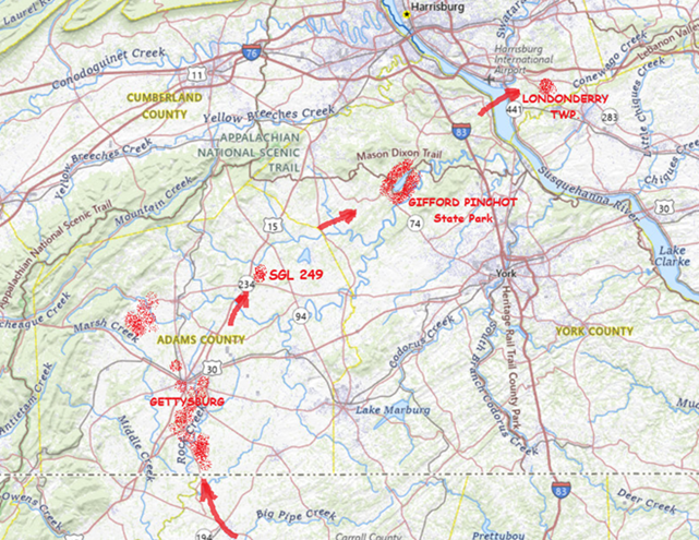


 Radiation")


 Watershed")


 Polar")