Fifty years ago this week, the remnants of Hurricane Agnes drifted north through the Susquehanna River basin as a tropical storm and saturated the entire watershed with wave after wave of torrential rains. The storm caused catastrophic flooding along the river’s main stem and along many major tributaries. The nuclear power station at Three Mile Island, then under construction, received its first major flood. Here are some photos taken during the climax of that flood on June 24, 1972. The river stage as measured just upstream of Three Mile Island at the Harrisburg gauge crested at 33.27 feet, more than 10 feet above flood stage and almost 30 feet higher than the stage at present. At Three Mile Island and Conewago Falls, the river was receiving additional flow from the raging Swatara Creek, which drains much of the anthracite coal region of eastern Schuylkill County—where rainfall from Agnes may have been the heaviest.
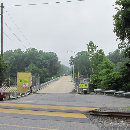
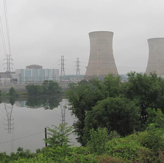
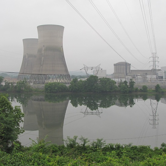
1972- From the river’s east shore at the mouth of Conewago Creek, Three Mile Island’s “south bridge” crosses the Susquehanna along the upstream edge of Conewago Falls. The flood crested just after covering the roadway on the span. Floating debris including trees, sections of buildings, steel drums, and rubbish began accumulating against the railings on the bridge’s upstream side, leading observers to speculate that the span would fail. When a very large fuel tank, thousands of gallons in capacity, was seen approaching, many thought it would be the straw that would break the camel’s back. It wasn’t, but the crashing sounds it made as it struck the bridge then turned and began rolling against the rails was unforgettable. (Larry L. Coble, Sr. image)1972- In this close-up of the preceding photo, the aforementioned piles of junk can be seen along the upstream side of the bridge (behind the sign on the right). The fuel tank struck and was rolling on the far side of this pile. (Larry L. Coble, Sr. image)2022- Three Mile Island’s “south bridge” as it appeared this morning, June 24,2022.1972- The railroad along the east shore at Three Mile Island’s “south bridge” was inundated by rising water. This flooded automobile was one of many found in the vicinity. Some of these vehicles were overtaken by rising water while parked, others were stranded while being driven, and still others floated in from points unknown. (Larry L. Coble, Sr. image)2022- A modern view of the same location.1972- At the north end of Three Mile Island, construction on Unit 1 was halted. The completed cooling towers can be seen to the right and the round reactor building can be seen behind the generator building to the left. The railroad grade along the river’s eastern shore opposite the north end of the island was elevated enough for this train to stop and shelter there for the duration of the flood. (Larry L. Coble, Sr. image)2022- Three Mile Island Unit 1 as it appears today: shut down, defueled, and in the process of deconstruction.1972- In March of 1979, the world would come to know of Three Mile Island Unit 2. During Agnes in June of 1972, flood waters surrounding the plant resulted in a delay of its construction. In the foreground, note the boxcar from the now defunct Penn Central Railroad. (Larry L. Coble, Sr. image)2022- A current look at T.M.I. Unit 2, shut down since the accident and partial meltdown in 1979.
Pictures capture just a portion of the experience of witnessing a massive flood. Sometimes the sounds and smells of the muddy torrents tell us more than photographs can show.
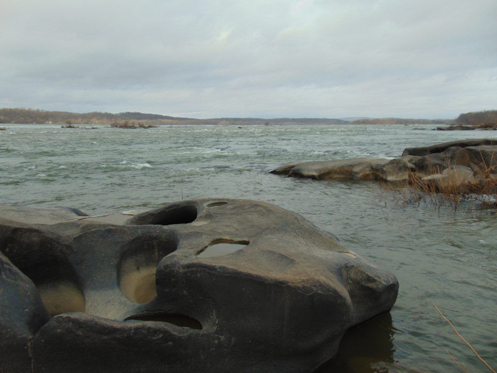
Aside from the booming noise of the fuel tank banging along the rails of the south bridge, there was the persistent roar of floodwaters, at the rate of hundreds of thousands of cubic feet per second, tumbling through Conewago Falls on the downstream side of the island. The sound of the rapids during a flood can at times carry for more than two miles. It’s a sound that has accompanied the thousands of floods that have shaped the falls and its unique diabase “pothole rocks” using abrasives that are suspended in silty waters after being eroded from rock formations in the hundreds of square miles of drainage basin upstream. This natural process, the weathering of rock and the deposition of the material closer to the coast, has been the prevailing geologic cycle in what we now call the Lower Susquehanna River Watershed since the end of the Triassic Period, more than two hundred million years ago.
More than the sights and sounds, it was the smell of the Agnes flood that warned witnesses of the dangers of the non-natural, man-made contamination—the pollution—in the waters then flowing down the Susquehanna.
Because they float, gasoline and other fuels leaked from flooded vehicles, storage tanks, and containers were most apparent. The odor of their vapors was widespread along not only along the main stem of the river, but along most of the tributaries that at any point along their course passed through human habitations.
Blended with the strong smell of petroleum was the stink of untreated excrement. Flooded treatment plants, collection systems overwhelmed by stormwater, and inundated septic systems all discharged raw sewage into the river and many of its tributaries. This untreated wastewater, combined with ammoniated manure and other farm runoff, gave a damaging nutrient shock to the river and Chesapeake Bay.
Adding to the repugnant aroma of the flood was a mix of chemicals, some percolated from storage sites along watercourses, and yet others leaking from steel drums seen floating in the river. During the decades following World War II, stacks and stacks of drums, some empty, some containing material that is very dangerous, were routinely stored in floodplains at businesses and industrial sites throughout the Susquehanna basin. Many were lifted up and washed away during the record-breaking Agnes flood. Still others were “allowed” to be carried away by the malicious pigs who see a flooding stream as an opportunity to “get rid of stuff”. Few of these drums were ever recovered, and hundreds were stranded along the shoreline and in the woods and wetlands of the floodplain below Conewago Falls. There, they rusted away during the next three decades, some leaking their contents into the surrounding soils and waters. Today, there is little visible trace of any.
During the summer of ’72, the waters surrounding Three Mile Island were probably viler and more polluted than at any other time during the existence of the nuclear generating station there. And little, if any of that pollution originated at the facility itself.
The Susquehanna’s floodplain and water quality issues that had been stashed in the corner, hidden out back, and swept under the rug for years were flushed out by Agnes, and she left them stuck in the stinking mud.
There are two Conewago Creek systems in the Lower Susquehanna River Watershed. One drains the Gettysburg Basin west of the river, mostly in Adams and York Counties, then flows into the Susquehanna at the base of Conewago Falls. The other drains the Gettysburg Basin east of the river, flowing through Triassic redbeds of the Gettysburg Formation and York Haven Diabase before entering Conewago Falls near the south tip of Three Mile Island. Both Conewago Creeks flow through suburbia, farm, and forest. Both have their capacity to support aquatic life impaired and diminished by nutrient and sediment pollution.
This week, some of the many partners engaged in a long-term collaboration to restore the east shore’s Conewago Creek met to have a look at one of the prime indicators of overall stream habitat health—the fishes. Kristen Kyler of the Lower Susquehanna Initiative organized the effort. Portable backpack-mounted electrofishing units and nets were used by crews to capture, identify, and count the native and non-native fishes at sampling locations which have remained constant since prior to the numerous stream improvement projects which began more than ten years ago. Some of the present-day sample sites were first used following Hurricane Agnes in 1972 by Stambaugh and Denoncourt and pre-date any implementation of sediment and nutrient mitigation practices like cover crops, no-till farming, field terracing, stormwater control, nutrient management, wetland restoration, streambank fencing, renewed forested stream buffers, or modernized wastewater treatment plants. By comparing more recent surveys with this baseline data, it may be possible to discern trends in fish populations resulting not only from conservation practices, but from many other variables which may impact the Conewago Creek Warmwater Stream ecosystem in Dauphin, Lancaster, and Lebanon Counties.
So here they are. Enjoy these shocking fish photos.
Matt Kofroth, Watershed Specialist with the Lancaster County Conservation District, operates the electrofishing wand in Conewago Creek while his team members prepare to net and collect momentarily-stunned fish. Three other electrofishing units operated by staff from the Susquehanna River Basin Commission and aided by teams of netters were in action at other sample locations along the Conewago on this day.Really big fish, such as this Common Carp (Cyprinus carpio), were identified, counted, and immediately returned to the water downstream of the advancing electrofishing team. Other fish, such as the Swallowtail Shiner, Redbreast Sunfish (Lepomis auritus), Fallfish, and suckers seen here, were placed in a sorting tank.Fallfish (Semotilus corporalis) are very active and require plenty of dissolved oxygen in the water to survive. Fallfish, Rainbow Trout (Oncorhynchus mykiss), and Smallmouth Bass (Micropterus dolomieu) were quickly identified and removed from the sorting tank for release back into the stream. Other larger, but less active fish, including suckers, quickly followed.Small fish like minnows were removed from the sorting tank for a closer look in a hand-held viewing tank. This Fathead Minnow (Pimephales promelas) was identified, added to the tally sheet, and released back into the Conewago. The Fathead Minnow is not native to the Susquehanna drainage. It is the minnow most frequently sold as bait by vendors.A breeding condition male Bluntnose Minnow (Pimephales notatus).The Cutlips Minnow (Exoglossum maxillingua) is a resident of clear rocky streams. Of the more than 30 species collected during the day, two native species which are classified as intolerant of persisting stream impairment were found: Cutlips Minnow and Swallowtail Shiner.The Central Stoneroller (Campostoma anomalum) is a benthic feeder in creeks over gravel and sand.The Eastern Blacknose Dace (Rhinichthys atratulus) is found in clear water over pebble and stone substrate.The Longnose Dace (Rhinichthys cataractae) is another species of pebbly rocky streams.A juvenile Golden Shiner (Notemigonus crysoleucas). Adults lack the side stripe and grow to the size of a sunfish.A Swallowtail Shiner (Notropis procne) and a very young White Sucker (Catostomus commersonii) in the upper left of the tank.A probable Spotfin Shiner (Cyprinella spiloptera).A breeding male Cyprinella shiner, probably a Spotfin Shiner. Show-off!The Margined Madtom (Noturus insignis) is a small native catfish of pebbly streams.The Banded Killifish (Fundulus diaphanus) is adept at feeding upon insects, including mosquitos.A young Rock Bass (Ambloplites rupestris). This species was introduced to the Susquehanna and its tributaries.The Greenside Darter (Etheostoma blennioides) is not native to the Susquehanna basin. The species colonized the Conewago Creek (east) from introduced local populations within the last five years.The Tessellated Darter (Etheostoma olmstedi) is a native inhabitant of the Susquehanna and its tributaries.The stars of the day were the American Eels (Anguilla rostrata).After collection, each eel was measured and weighed using a scale and dry bucket. This specimen checked in at 20 inches and one pound before being released.Prior to the construction of large dams, American Eels were plentiful in the Susquehanna and its tributaries, including the Conewago. They’ve since been rarities for more than half a century. Now they’re getting a lift.American Eels serve as an intermediate host for the microscopic parasitic glochidia (larvae) of the Eastern Elliptio (Elliptio complanata), a declining native freshwater mussel of the Lower Susquehanna River Watershed. While feeding on their host (usually in its gills), the glochidia cause little injury and soon drop off to continue growth, often having assured distribution of their species by accepting the free ride. Freshwater mussels are filter feeders and improve water quality. They grow slowly and can live for decades.American Eels are a catadromous species, starting life as tiny glass eels in the saltwater of the Atlantic Ocean, then migrating to tidal brackish marshes and streams (males) or freshwater streams (females) to mature. This 20-incher probably attempted to ascend the Susquehanna as an elver in 2016 or 2017. After hitching a ride with some friendly folks, she bypassed the three largest dams on the lower Susquehanna (Conowingo, Holtwood, and Safe Harbor) and arrived in the Conewago where she may remain and grow for ten years or more. To spawn, a perilous and terminally fatal journey to the Sargasso Sea awaits her. (You may better know the area of the Sargasso Sea as The Bermuda Triangle…a perilous place to travel indeed!)
SOURCES
Normandeau Associates, Inc. and Gomez and Sullivan. 2018. Muddy Run Pumped Storage Project Conowingo Eel Collection Facility FERC Project 2355. Prepared for Exelon.
Stambaugh, Jr., John W., and Robert P. Denoncourt. 1974. A Preliminary Report on the Conewago Creek Faunal Survey, Lancaster County, Pennsylvania. Proceedings of the Pennsylvania Academy of Sciences. 48: 55-60.
It was one of the very first of my memories. From the lawn of our home I could look across the road and down the hill through a gap in the woodlands. There I could see water, sometimes still with numerous boulders exposed, other times rushing, muddy, and roaring. Behind these waters was a great stone wall and beyond that a wooded hillside. I recall my dad asking me if I could see the dam down there. I couldn’t see a dam, just fascinating water and the gray wall behind it. I looked and searched but not a trace of a structure spanning the near to far shore was to be seen. Finally, at some point, I answered in the affirmative to his query; I could see the dam…but I couldn’t.
We lived in a small house in the village of Falmouth along the Susquehanna River in the northwest corner of Lancaster County over fifty years ago. A few years after we had left our riverside domicile and moved to a larger town, the little house was relocated to make way for an electric distribution sub-station and a second set of electric transmission wires in the gap in the woodlands. The Brunner Island coal-fired electric generating station was being upgraded downstream and, just upstream, a new nuclear-powered generating station was being constructed on Three Mile Island. To make way for the expanding energy grid, our former residence was trucked to a nearby boat landing where there were numerous other river shacks and cabins. Because it was placed in the floodplain, the building was raised onto a set of wooden stilts to escape high water. It didn’t help. The record-breaking floods of Hurricane Agnes in June of 1972 swept the house away.
The view through the cut in the woodland, a little wider than in the early 1960s with the addition of the newer electric transmission wire towers. The “Wall” is the same.
During the time we lived along the Susquehanna, the river experienced record-low flow rates, particularly in the autumn of 1963 and again in 1964. My dad was a dedicated 8mm home-movie photographer. Among his reels was film of buses parked haphazardly along the road (PA Route 441 today) near our home. Sightseers were coming to explore the widely publicized dry riverbed and a curious moon-like landscape of cratered rocks and boulders. It’s hard to fathom, but people did things like that during their weekends before Sunday-afternoon football was invented. Scores of visitors climbed through the rocks and truck-size boulders inspecting this peculiar scene. My dad, his friends, and so many others with camera in hand were experiencing the amazing geological feature known as the Pothole Rocks of Conewago Falls.
Conewago Falls on the Susquehanna River and several exposed York Haven Diabase Pothole Rocks. Lancaster (foreground) and Dauphin (center) Counties meet along a southwest to northeast borderline through the rapids. Lands on the west shoreline in the background are in York County. Three Mile Island is seen in the upper right.
The river here meets serious resistance as it pushes its way through the complex geology of south-central Pennsylvania. These hard dark-gray rocks, York Haven Diabase, are igneous in origin. Diabase sheets and sills intruded the Triassic sediments of the Gettysburg Formation here over 190 million years ago. It may be difficult to visualize, but these sediments were eroded from surrounding mountains into the opening rift valley we call the Gettysburg Basin. This rift and others in a line from Nova Scotia to Georgia formed as the supercontinent Pangaea began dividing into the continents we know today. Eventually the Atlantic Ocean rift would dominate as the active dynamic force and open to separate Africa from North America. The inactive Gettysburg Basin, filled with sediments and intruded by igneous diabase, would henceforth, like the mountainous highlands surrounding it, be subjected to millions of years of erosion. Of the regional rocks, the formations of Triassic redbeds, sandstones, and particularly diabase in the Gettysburg Basin are among the more resistant to the forces of erosion. Many less resistant older rocks, particularly those of surrounding mountains, are gone. Today, the remains of the Gettysburg Basin’s rock formations stand as rolling highlands in the Piedmont Province.
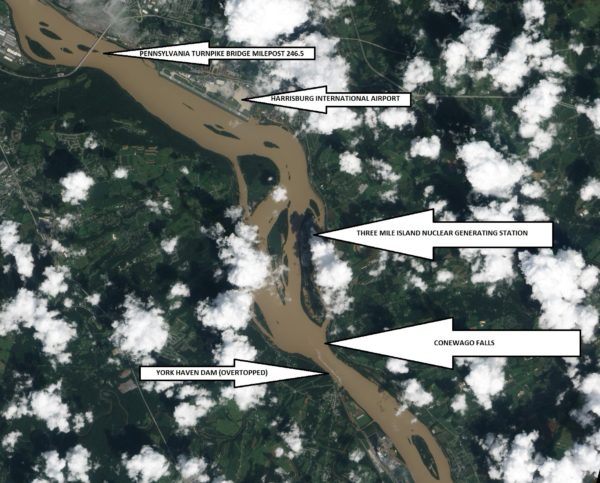
Flooded from the heavy rains of Tropical Storm Lee, the sediment-laden Susquehanna River flows through the Gettysburg Basin just south of Harrisburg, PA, September 10, 2011. The “Wall” as seen from space. (NASA Earth Observatory Image)
The weekend visitors in 1963 and 1964 marveled at evidence of the river’s fight to break down the hard York Haven Diabase. Scoured bedrock traced the water’s turbulent flow patterns through the topography of the falls. Meltwater from the receding glaciers of the Pleistocene Ice Ages thousands to tens of thousands of years ago raged in high-volume, abrasive-loaded torrents to sculpt the Pothole Rocks into the forms we see today. Our modern floodwaters with ice and fine suspended sediments continue to wear at the smooth rocks and boulders, yet few are broken or crumbled to be swept away. It’s a very slow process. The river elevation here drops approximately 19 feet in a quarter of a mile, a testament to the bedrock’s persisting resistance to erosion. Conewago Falls stands as a natural anomaly on a predominantly uniform gradient along the lower Susquehanna’s downhill path from the Appalachian Mountains to the Chesapeake Bay.
Normally the scene of dangerous tumbling rapids, the drought and low water of 1963 and 1964 had left the falls to resemble a placid scene—a moonscape during a time when people were obsessed with mankind’s effort to visit earth’s satellite. Visitors saw the falls as few others had during the twentieth century. Dr. Herbert Beck of Franklin and Marshall College described an earlier period of exposure, “…pot holes…were uncovered during the third week in October, 1947, for the first time in the memory of man, when the drought parched Susquehanna River retreated far below its normal low stage”. Then, as in 1963 and on occasions more recent, much of it was due to the presence of the wall. I had to be a bit older than four years old to grasp it. You see the wall and the dam are one and the same. The wall is the York Haven Dam. And it is responsible for channeling away the low flow of the Susquehanna during periods of drought so that we might have the opportunity to visit and explore the Pothole Rocks of Conewago Falls along the river’s east shore.
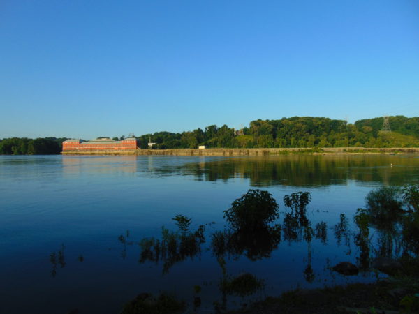
The initial segment of the dam, a crib structure built in 1885 by the York Haven Paper Company to supply water power to their mill, took advantage of the geomorphic features of the diabase bedrock of Conewago Falls to divert additional river flow into the abandoned Conewago Canal. The former canal, opened in 1797 to allow passage around the rapids along the west shore, was being used as a headrace to channel water into the grinding mill’s turbines. Strategic placement of this first wall directed as much water as possible toward the mill with the smallest dam practicable. The York Haven Power Company incorporated the paper mill’s crib dam into the “run-of-the-river” dam built through the falls from the electric turbine powerhouse they constructed on the west shore to the southern portion of Three Mile Island more than a mile away. The facility began electric generation in 1904. The construction of the “Red Hill Dam” from the east shore of Three Mile Island to the river’s east shore made York Haven Dam a complete impoundment on the Susquehanna. The pool, “Lake Frederic”, thus floods that portion of the Pothole Rocks of Conewago Falls located behind the dam. On the downstream side, water spilling over or through the dam often inundates the rocks or renders them inaccessible.
During the droughts of the early 1960s, diversion of nearly all river flow to the York Haven Dam powerhouse cleared the way for weekend explorers to see the Pothole Rocks in detail. Void of water, the intriguing bedrock of Conewago Falls below the dam greeted the curious with its ripples, cavities, and oddity. It was an opportunity nature alone would not provide. It was all because of the wall.
York Haven Dam and powerhouse. The “Wall” traverses Conewago Falls upstream to Three Mile Island to direct water to the powerhouse on the west shore of the Susquehanna River.
SOURCES
Beck, Herbert H. 1948. “The Pot Holes of Conewago Falls”. Proceedings of the Pennsylvania Academy of Science. Penn State University Press. 22: pp. 127-130.
Smith, Stephen H. 2015. #6 York Haven Paper Company; on the Site of One of the Earliest Canals in America. York Past website www.yorkblog.com/yorkpast/2015/02/17/6-york-haven-paper-company-on-the-site-of-one-of-the-earliest-canals-in-america/ as accessed July 17, 2017.
Stranahan, Susan Q. 1993. Susquehanna, River of Dreams. The Johns Hopkins University Press. Baltimore, Maryland.
Van Diver, Bradford B. 1990. Roadside Geology of Pennsylvania. Mountain Press Publishing Company. Missoula, Montana.