The majority of floodplains in the Lower Susquehanna River Watershed are, to put it mildly, dysfunctional. They are frequently disconnected from the lotic (flowing) streams and rivers that created them and are no longer capable of absorbing, purifying, and infiltrating high water during rain and snow-melt events. They are an ongoing source of nutrient and sediment pollution that impairs both our local waterways and Chesapeake Bay. For the plant and wildlife species that rely upon them for survival, their loss has been catastrophic.
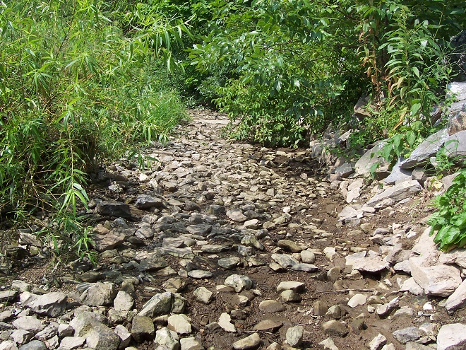
Mill dams once impounded nearly every mile of low-gradient streams in the lower Susquehanna region. During the century or more of their existence prior to the implementation of soil conservation practices during the 1930s, sediments consisting mostly of nutrient-loaded clay, silt, and sand eroded from sloped terrain in storm runoff and accumulated behind these dams, filling many to the brim with mud—six, eight, ten, sometimes twelve feet deep! As the dams fail or are removed, the stream is left channelized, incising a path through a floodplain choked with these “legacy sediments”.
That’s it, a fresh layer of topsoil oughta do it- Landowners have become so accustomed to legacy sediment pollution and channelized creeks, they think it’s how a natural stream and floodplain ecosystem looks and operates. They’ll even replace washed away legacy sediment with dirt, rocks, cinder blocks, old sidewalks, and other construction debris to “shore things up”. It’s a delusional approach to managing a space that functions as a place to store, treat, and percolate precious water.Legacy sediments not only displace flood waters into historically unimpacted lands, they clog the hyporheic zone, the area below and alongside the flowing stream where water is exchanged with the aquifer. (United States Geological Survey image)Restoration of creeks and floodplains impacted by legacy sediment pollution includes the removal of the layer of nutrient-loaded sand, silt, and clay deposited atop the historic stratum of wetland and stream substrates. These lower layers are frequently gray in color and contain gravel from the former stream beds. Within the organic matter contained in this historic layer, seeds of native wetland plants have rested dormant for more than one hundred years. Some are still viable and will germinate upon liberation from the overlying legacy layer.Stockpiles of legacy sediments and larger fill items await transport to upland sites for reuse following removal from the impaired floodplain during a stream restoration project completed during the past year on Swarr Run, a tributary of Little Conestoga Creek in Lancaster County, Pennsylvania. This excavation, part of the project’s phase-two plan, was preceded in 2020 by similar construction completed as phase one on a segment located just upstream.Swarr Run has been returned to a meandering stream course in a floodplain cleared of nutrient-rich legacy sediments. How are legacy sediments repurposed? Those from previous projects in the lower Susquehanna valley have been used to create a community garden, as a top coating on athletic fields, as a safety backstop at a shooting range, and as topsoil on some of the croplands from whence they came all those years ago.Restoring pool and riffle or meandering stream flow regimes also restores water exchange in the adjoining hyporheic zones. (United States Geological Survey image)Removing legacy sediment accumulations from the floodplains of impaired streams allows re-establishment of historic flow regimes and reconnection of the waterway to the nutrient-sequestering functions of fluvial wetlands. In addition, flow into and from the water table is restored.Question: Do you know why nearby businesses have ATMs? Answer: Because there are no longer any banks on this segment of Swarr Run.
For a closer look at the Swarr Run renewal, including early map and aerial photograph views of the site, take a peek at this synopsis illustrating phase one of the project as presented to the North American Association of Wetland Managers by Justin Spangler of LandStudies, designers of the restoration. While perusing the material, be sure to review the significant reductions in nutrient and sediment loads discharged from these sites following the restoration work.
Floodplain restorations that include legacy sediment removal are often designed to reduce the impact of stormwater from sheet runoff, piped discharges, or conveyances such as eroded and excavated ditches like this one. Projects that restore floodplain functions including storing, filtering, and percolating runoff effectively can sometimes help municipalities and property owners meet regulatory stormwater requirements, including those under the Environmental Protection Agency’s MS4 (Municipal Separate Storm Sewer System) program.This floodplain restoration was completed during the past year along a segment of Little Conestoga Creek in Lancaster, Pennsylvania. Here the stream receives a heavy dose of stormwater runoff from shopping malls and other commercial properties with acres upon acres of paved parking space. Because they lack connection to any retention or detention systems, storm drains pipe runoff directly from the pavement into the creek from many of these properties.Legacy sediment removal eliminates the steep banks along the channelized creek. Braided stream courses were added to again connect the Little Conestoga to its historic floodplain and a complex of wetlands to help store, treat, and infiltrate stormwater.Removing legacy sediments brings an end to their practice of forcing detrimental high waters out to roam adjacent neighborhoods, putting floods back in the floodplain where they belong.Completed last year in conjunction with replacement of an aging sanitary sewer interceptor (buried to the right), this floodplain restoration removed legacy sediments and returned Conoy Creek in Lancaster County, Pennsylvania, to a natural, braided stream course.As part of the project, municipal storm drain discharges were withdrawn from the edge of the channelized stream to now flow runoff into the floodplain wetlands for storage, thermal moderation, nutrient sequestering, and infiltration. The braided stream design connects the waterway to these wetlands and helps restore the hyporheic functions between the Conoy and its underlying New Oxford Formation sandstone aquifer. This project helped the local municipality meet its MS4 (Municipal Separate Storm Sewer System) requirements.Following restoration, a braided stream design reconnects Cocalico Creek in Lancaster County, Pennsylvania, to its floodplain wetlands along this 3,867-foot segment near its headwaters. As part of the construction process, twenty-five acres of invasive growth was treated prior to the planting of 12.7 acres of native riparian buffer species. According to the Pennsylvania Department of Environmental Protection’s (DEP) project summary, annual pollutant load reductions resulting from this restoration are calculated to be 862,980 pounds of Total Suspended Sediments/year, 1,641 pounds of Total Nitrogen/year, and 426 pounds of Total Phosphorus/year.The stream and floodplain restoration on Cocalico Creek is beginning its fifth year since completion. It recreates marshlands that purify the stream’s waters while providing prime habitat for native plants and animals. See the LandStudies project summary here.Hammer time- Now under construction: after years of planning and preparations, a floodplain and stream restoration on Hammer Creek near Buffalo Springs in Lebanon County, Pennsylvania, returns this low-gradient segment to a meandering flow regime. Instead of a ditch between fields, it’ll once again be a creek connected to a nutrient-reducing wetland buffer.
Have an impaired stream and a floodplain full of legacy sediments on your land or in your neighborhood? Consider encouraging your municipality, volunteer watershed group, or county conservation district to investigate the possibilities of planning and installing one of these projects. They’re a great enhancement for recreational fisheries, a private refugium, or a community-owned passive park system. Funding assistance may be available, particularly when regulatory or conservation goals can be met by completing restoration.
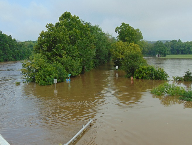
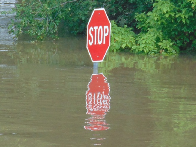
It was a routine occurrence in many communities along tributaries of the lower Susquehanna River during the most recent two months. The rain falls like it’s never going to stop—inches an hour. Soon there is flash flooding along creeks and streams. Roads are quickly inundated. Inevitably, there are motorists caught in the rising waters and emergency crews are summoned to retrieve the victims. When the action settles, sets of saw horses are brought to the scene to barricade the road until waters recede. At certain flood-prone locations, these events are repeated time and again. The police, fire, and Emergency Medical Services crews seem to visit them during every torrential storm—rain, rescue, rinse, and repeat.
We treat our local streams and creeks like open sewers. Think about it. We don’t want rainwater accumulating on our properties. We pipe it away and grade the field, lawn, and pavement to roll it into the neighbor’s lot or into the street—or directly into the waterway. It drops upon us as pure water and we instantly pollute it. It’s a method of diluting all the junk we’ve spread out in its path since the last time it rained. A thunderstorm is the big flush. We don’t seem too concerned about the litter, fertilizer, pesticides, motor fluids, and other consumer waste it takes along with it. Out of sight, out of mind.
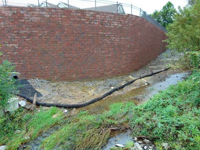
Failure to retain and infiltrate stormwater to recharge aquifers can later result in well failures and reduced base flow in streams. (Conoy Creek’s dry streambed in June, 2007)
Perhaps our lack of respect for streams and creeks is the source of our complete ignorance of the function of floodplains.
Floodplains are formed over time as hydraulic forces erode bedrock and soils surrounding a stream to create adequate space to pass flood waters. As floodplains mature they become large enough to reduce flood water velocity and erosion energy. They then function to retain, infiltrate, and evaporate the surplus water from flood events. Microorganisms, plants, and other life forms found in floodplain wetlands, forests, and grasslands purify the water and break down naturally-occurring organic matter. Floodplains are the shock-absorber between us and our waterways. And they’re our largest water treatment facilities.
Why is it then, that whenever a floodplain floods, we seem motivated to do something to fix this error of nature? Man can’t help himself. He has a compulsion to fill the floodplain with any contrivance he can come up with. We dump, pile, fill, pave, pour, form, and build, then build some more. At some point, someone notices a stream in the midst of our new creation. Now it’s polluted and whenever it storms, the darn thing floods into our stuff—worse than ever before. So the project is crowned by another round of dumping, forming, pouring, and building to channelize the stream. Done! Now let’s move all our stuff into our new habitable space.
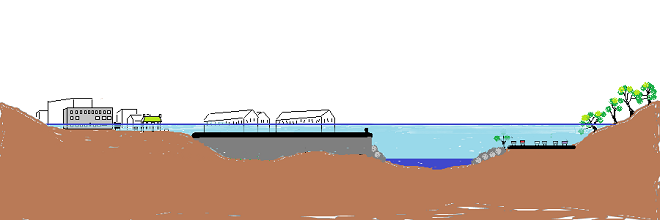
Natural Floodplain- Over a period of hundreds or thousands of years, the stream (dark blue) has established a natural floodplain including wetlands and forest. In this example, buildings and infrastructure are located outside the zone inundated by high water (light blue) allowing the floodplain to function as an effective water-absorbing buffer.Impaired Floodplain- Here the natural floodplain has been filled for building (left) and paved for recreation area parking (right). The stream has been channelized. Flood water (light blue) displaced by these alterations is likely to inundate areas not previously impacted by similar events. Additionally, the interference with natural flow will create new erosion points that could seriously damage older infrastructure and properties.
The majority of the towns in the lower Susquehanna valley with streams passing through them have impaired floodplains. In many, the older sections of the town are built on filled floodplain. Some new subdivisions highlight streamside lawns as a sales feature—plenty of room for stockpiling your accoutrements of suburban life. And yes, some new homes are still being built in floodplains.
When high water comes, it drags tons of debris with it. The limbs, leaves, twigs, and trees are broken down by natural processes over time. Nature has mechanisms to quickly cope with these organics. Man’s consumer rubbish is another matter. As the plant material decays, the embedded man-made items, particularly metals, treated lumber, plastics, Styrofoam, and glass, become more evident as an ever-accumulating “garbage soil” in the natural floodplains downstream of these impaired areas. With each storm, some of this mess floats away again to move ever closer to Chesapeake Bay and the Atlantic. Are you following me? That’s our junk from the curb, lawn, highway, or parking lot bobbing around in the world’s oceans.
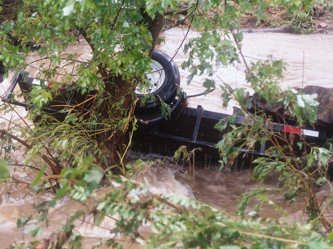
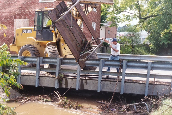
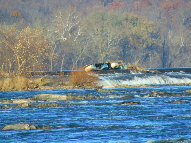
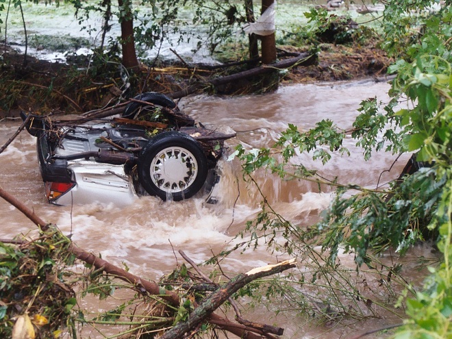
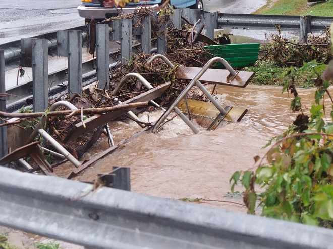
A shed, mobile home, or house can be inundated or swept away during a flood. Everything inside (household chemicals, gasoline, fuel oil, pesticides, insulation, all those plastics, etc.) instantly pollutes the water. Many communities that rely on the Susquehanna River for drinking water are immediately impacted, including Lancaster, PA and Baltimore, MD. This dumpster was swept away from a parking lot in a floodplain. It rolled in the current, chipping away at the bridge before spilling the rubbish into the muddy water. After the flood receded, the dumpster was found a mile downstream. Its contents are still out there somewhere.Floodplains along the lower Susquehanna River are blanketed with a layer of flotsam that settles in place as high water recedes. These fresh piles can be several feet deep and stretch for miles. Nature decomposes the organic twigs and driftwood to build soil-enriching humus. However, the plastics and other man-made materials that do not readily decay or do not float away toward the sea during the next flood are incorporated into the alluvium and humus creating a “garbage soil”. Over time, the action of abrasives in the soil will grind small particles of plastics from the larger pieces. These tiny plastics can become suspended in the water column each time the river floods. What will be the long-term impact of this type of pollution?Anything can be swept away by the powerful hydraulic forces of flowing water. Large objects like this utility trailer can block passages through bridges and escalate flooding problems.The cost of removing debris often falls upon local government and is shared by taxpayers.Here, a junked boat dock is snagged on the crest of the York Haven Dam at Conewago Falls. Rising water eventually carried it over the dam and into the falls where it broke up. This and tons of other junk are often removed downstream at the Safe Harbor Dam to prevent damage to turbine equipment. During periods of high water, the utility hauls debris by the truck-load to the local waste authority for disposal. For the owners of garbage like this dock, it’s gone and it’s somebody else’s problem now.Motor vehicles found after floating away from parking areas in floodplains can create a dangerous dilemma for police, fire, and E.M.S. personnel, particularly when no one witnesses the event. Was someone driving this car or was it vacant when it was swept downstream? Should crews be put at risk to locate possible victims?
Beginning in 1968, participating municipalities, in exchange for having coverage provided to their qualified residents under the National Flood Insurance Program, were required to adopt and enforce a floodplain management ordinance. The program was intended to reduce flood damage and provide flood assistance funded with premiums paid by potential victims. The program now operates with a debt incurred during severe hurricanes. Occurrences of repetitive damage claims and accusations that the program provides an incentive for rebuilding in floodplains have made the National Flood Insurance Program controversial.
In the Lower Susquehanna River Watershed there are municipalities that still permit new construction in floodplains. Others are quite proactive at eliminating new construction in flood-prone zones, and some are working to have buildings removed that are subjected to repeated flooding.
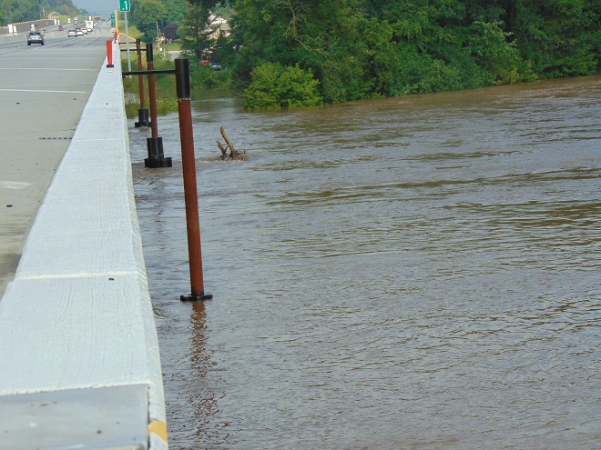
Another Wall— Here’s an example of greed by the owner, engineer, and municipality… placing their financial interests first. The entire floodplain on the north side of this stream was filled, then the wall was erected to contain the material. A financial institution’s office and parking lot was constructed atop the mound. This project has channelized the stream and completely displaced half of the floodplain to a height of 15 to 20 feet. Constructed less than five years ago, the wall failed already and has just been totally reconstructed. The photo reveals how recent flooding has begun a new erosion regime where energy is focused along the base of the wall. Impairment of a floodplain to this degree can lead to flooding upstream of the site and erosion damage to neighboring infrastructure including roads and bridges.The floodplain along this segment of the lower Swatara Creek in Londonderry Township, Dauphin County is free to flood. Ordinances prohibit new construction here and 14 older houses that repeatedly flooded were purchased, dismantled, and removed using funding from the Federal Emergency Management Agency (F.E.M.A). A riparian buffer was planted and some wetland restorations were incorporated into stormwater management installations along the local highways. When the waters of the Swatara rise, the local municipality closes the roads into the floodplain. Nobody lives or works there anymore, so no one has any reason to enter. There’s no need to rescue stubborn residents who refused advice to evacuate. Sightseers can park and stand on the hill behind the barricades and take all the photographs they like.A new Pennsylvania Turnpike bridge across Swatara Creek features wide passage for the stream below. Water flowing in the floodplain can pass under the bridge without being channelized toward the path where the stream normally flows in the center. The black asterisk-shaped floats spin on the poles to help deflect debris away from the bridge piers. (flood crest on July 26, 2018)People are curious when a waterway floods and they want to see it for themselves. Wouldn’t it be wise to anticipate this demand for access by being ready to accommodate these citizens safely? Isn’t a parking lot, picnic area, or manicured park safer and more usable when overlooking the floodplain as opposed to being located in it? Wouldn’t it be a more prudent long-term investment, both financially and ecologically, to develop these improvements on higher ground outside of flood zones?Now would be a good time to stop the new construction and the rebuilding in floodplains. Aren’t the risks posed to human life, water quality, essential infrastructure, private property, and ecosystems too great to continue?Isn’t it time to put up the white flag and surrender the floodplains to the floods? That’s why they’re there. Floodplains are for flooding.