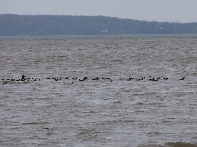
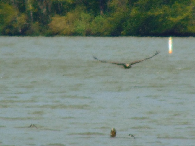
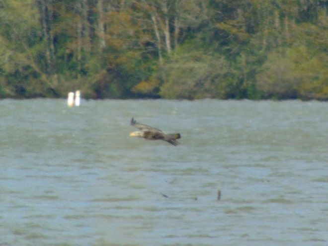
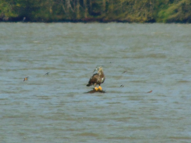
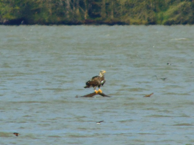
As they travel between coastal wintering ranges and breeding territories in Canada and Alaska, vast numbers of shorebirds pass through the lower Susquehanna region each spring and fall—though few stop here to rest, feed, and provide us with an opportunity to observe them. Prior to the construction of man-made dams and other alterations on our lotic (flowing) waterways including the river, shorebirds took advantage of lateral bars, stream deltas, and other alluvial deposits as places to loaf and re-energize. Before they were drained and filled, some of the valley’s wetlands probably included sparsely vegetated flats where shorebirds could drop in for a brief visit. Previous to their extirpation from our region, North American Beavers were the primary providers of quality habitat for shorebirds and other migrating waders on our lotic waters. Their widespread network of dams, pools, and marshes maximized floodplain function by keeping streams thoroughly connected to their wetlands, nurturing plant communities that not only provided food and shelter for the beavers and other wildlife, but provided superb buffering against erosion while protecting against sediment and nutrient imbalances in lower Susquehanna waterways.
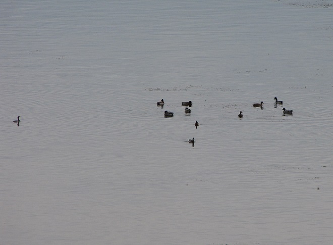
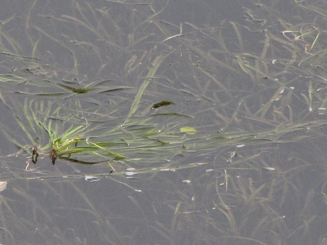
Beaver dams need not be large, particularly on low-gradient streams where a structure like this is sufficient to create a pool with depth adequate for building and maintaining a lodge and transporting leafy branches and other food items by water.A beaver lodge assembled in a pool with less than three feet of water, deep enough to provide the family with a measure of protection against terrestrial predators.Beaver pool ecosystems provide homes for hundreds of species of plants and animals, including migrating shorebirds and other waders.Mud flats in the margins between emergent shrubs and herbaceous plant growth attract migrating shorebirds like this Solitary Sandpiper to the abundance of invertebrate life. Seasonal movements of migrating shorebirds regularly coincide with the reductions of water levels in beaver pools which typically occur between May and September each year.During its southbound migration in September, a Least Sandpiper searches for arthropods and annelids as it visits a food-rich puddle along the periphery of a beaver pool.A Pectoral Sandpiper feeds in shallow water near a stand of Common Cattails in a beaver pool.During migration, rails including the Sora are attracted to dense emergent vegetation in beaver pools. Some will nest in these rodent-managed refugia.Green Herons visit beaver pools during migration and, due to the reliability of the food supply, will often nest in their vicinity.
So how did this happen? How did the North American Beaver become a keystone species—an animal upon which the majority of other life forms within its ecosystem are so reliant? Well, it’s largely due to the fact that our beavers aren’t particularly fond of a constant stream of noise. More specifically, they don’t like the sound of running water in places where they intend to build and maintain a lodge. And so, as they begin to place sticks, mud, limbs, stones, and other materials within a noisy riffle on a stream, they create a dam, and behind it a pool—a pool that is particularly advantageous for protecting their home and providing a means of conveyance for their construction materials and food supplies.
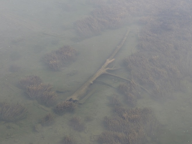
On a high-gradient segment of stream, beavers will create a cascading series of pools. Because water filters through a beaver dam instead of spilling over it, the work of these meticulous rodents soon silences the sounds of water changing altitude. No more sonorous riffle.Quiet please. High seasonal stream flow and damage from storms may create areas where water begins to erode the structure of the dam. Where this condition persists, an adult beaver will soon mend the breach, just to quiet things down. Why would beavers demand such a hush upon their domain? Well, they have poor eyesight, but their hearing is excellent, and they rely upon it to detect danger.The Louisiana Waterthrush (Parkesia motacilla), one of our earliest-arriving warblers, nests in forests along clear, high-gradient streams. In mid-April, we found this individual and three others squabbling over a breeding territory adjacent to the series of cascading beaver pools shown in the previous images.Native denizens of coldwater streams, neither the Brook Trout nor the Eastern Blacknose Dace has any difficulty finding its way through the voids in beaver dams to ascend and descend the sequence of pools.On a low-gradient segment of stream, a dam just over a foot in height may be sufficient to create a beaver pool of considerable size. Resembling the water-logged muskeg of the far north, well-established beaver pools form boggy habitats familiar to migrating shorebirds.Water levels in the pools usually drop along with the stream’s base flow as soon as the effects of the spring thaw and rain showers subside. Feeding areas in shallow water and on muddy ground are often revealed just in time for northbound shorebirds and other waders to stop by in late April and May. These conditions often persist through the growing season and the fall migration of these birds which begins as early as late June and sometimes extends into October.Where the pool inundates standing timber such as Red Maple and other species not used by beavers, the dead snags provide vital feeding areas for birds and other wildlife. Cavity nesters like this Tree Swallow seldom find suitable natural housing elsewhere.The mosaic of marshlands and braided stream channels within the beaver pool complex supports an abundance of aquatic life including these breeding Eastern Newts, seen here surrounded by the exuvia left behind following a massive hatch of alderflies (Sialinae). Alderflies are a stream inhabitant during their larval stage and are indicator of clean water conditions.A modern-day example of the way fully functional stream floodplains used to look in the Lower Susquehanna River Watershed. Though the pools may appear pond-like during the cooler and wetter months of the year, by summer the water levels behind the beaver dams recede as the base flow of the stream wanes. Now the true nature of the marsh, shallow pool, and braided stream complex is revealed. Unlike most man-made dams that set a fixed pool elevation regardless of flow by discharging water over the top of the structure or through a spillway or gate, beaver dams merely throttle the flow through their porous construction. Unless the beaver begins plugging small leaks as fast as the stream flow ebbs, the water level in the pools will drop. So they’re not left high and dry, lodges are located in the deepest pools, usually in close proximity to the dam and/or one of the stream courses. Though not inundated during the dry season, the soil in the pool complex is almost always damp and plants grow vigorously there, sequestering nutrients and retaining sediments in beneficial deposition patterns that actually inhibit erosion of the riparian landscape. These streams and floodplains retain their hyporheic zone and freely exchange water with the underlying water table and aquifer. It’s the ultimate floodplain management system, and the beavers don’t even know their doing all the work. (Google Maps base image)Where another high-gradient segment of stream enters the main pool complex, beavers have created an additional series of cascading pools. The impoundments created by these dams help diffuse stormwater energy and process more nutrients and sediments within the floodplain’s wetland vegetation system. (Google Maps base image)Beaver pools often refill as stream flows increase following autumn rains. The stockpiles of vegetative foods that grew within the beaver’s domain through the summer then become flooded and are a prime source of nutrition for not only the beavers, but waterfowl during both their autumn and spring migrations. Gleaning and probing Sandhill Cranes often find these habitats to their liking as well.
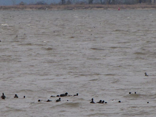
While North American Beavers have returned to the region, most live as “bank beavers”, residing in the river and larger creeks of the valley where they excavate shelters among the roots of Black Willows and other shoreline trees and shrubs. Floodplain encroachment, legacy sediment deposits, and just plain human intolerance have all conspired to prohibit North American Beavers from performing their magic on smaller local streams. For migrating shorebirds, this continued absence of beaver dam ecosystems has turned much of the lower Susquehanna valley into “flyover country”. Those travelers that do stop to rest and feed concentrate at the few favorable locations such as the lateral bars and the hydroelectric dam-created delta at the Conejohela Flats on the river in Lancaster County. But centralization has its drawbacks. Migrants spending time at concentration points may have a greater chance of contracting and spreading disease. Protracted heavy foraging can degrade these habitats. And over time, features such the lateral bars and delta deposits, including those on the Conejohela Flats, transition into other habitats—riparian forests. A more widespread selection of favorable stopover points for shorebirds, waders, waterfowl, and other migrants is certainly desirable.
IMITATION IS THE SINCEREST FORM OF FLATTERY
Until public sentiment sways in favor of the North American Beaver, wildlife managers are mimicking some of the attributes of their sound-inspired installations.
Created by excavating a depression in heavy clay soils, this new impoundment at the Pennsylvania Game Commission’s Middle Creek Wildlife Management Area collects water directly from rainfall and from surface runoff. Its depth at no point is greater than about two or three feet. During the driest times of the year, this space will be a mudflat, and a haven for migrating shorebirds.
Shallow-water conservation impoundments designed, constructed, and managed for migratory waterfowl and waders including shorebirds are not what we typically refer to as ponds—though they are lentic (still) waters. Similar shallow freshwater impoundments at our National Wildlife Refuges are referred to as pools by the United States Fish and Wildlife Service, but smaller versions like this example at Middle Creek very closely resemble the prairie potholes created by glacial scour in the north-central United States and adjacent portions of Canada. Many populations of migratory birds are familiar with pothole ecosystems and, like the beaver pools and marshes, have relied upon them as waypoints along their journeys for centuries.
Impoundments most beneficial to migrating waterfowl and waders including shorebirds are shallow in depth. They lack the deeper waters of a pond or lake and thus have no limnetic (open water) or aphotic zones. Managed throughout as a littoral zone, impoundments grow plants in shallow water or on damp soil through the summer months to chew up nutrients accumulated in waste deposited by visiting birds. This vegetation is then flooded from late fall through early spring as forage habitat for migratory waterfowl. The timing of the fluctuations in water levels approximates those of the beaver pools and marshes on lotic (flowing) waters.A gate assembly is a water control structure installed to provide seasonal management of the water levels in a conservation impoundment. More than once, beavers have heard the sounds of tumbling waters inside these types of devices and tried to dam them up!
You’ve heard the line, “If you build it, they will come.” Well, it’s true. Here is a sample of the activity witnessed during the past two weeks at the new impoundment completed just several months ago at Middle Creek Wildlife Management Area along the tour route just beyond the “Stop 3” overlook.
The ubiquitous Snow Geese were among the first migratory occupants of the new impoundment. A few are currently lingering in the vicinity.Ducks soon followed. These Blue-winged Teal were among the last to pass through earlier this month.Wilson’s Snipe were among the first species of migratory shorebirds to visit the new impoundment at Middle Creek……as were Killdeer, a species which nests nearby.Then, earlier this month, flocks of shorebirds including these Least Sandpipers were arriving to feed and rest.Least Sandpipers search for small invertebrates in shallow water and exposed soil.A Least Sandpiper (left) and a Semipalmated Sandpiper (right).Not all shorebirds seen by themselves are alone, and that includes the Solitary Sandpiper.Here’s a Solitary Sandpiper (right) feeding alongside a Least Sandpiper (center) and a White-rumped Sandpiper (left).A Least Sandpiper (left) and a White-rumped Sandpiper (right).Rare in our area during spring, the White-rumped Sandpiper (Calidris fuscicollis) flies north using the central flyway, then heads south along the Atlantic flyway in the fall, when it tends to be more regular here.Rocking and teetering along as it looks for food, the Spotted Sandpiper may be one of the easiest of shorebirds to identify.Chunky little Dunlin (Calidris alpina) with their conspicuously down-curved bills are another easy-to-identify species, particularly in the spring when their breeding (alternate) plumage includes a black belly.Black-bellied Plovers acquire a handsome set of plumage in the spring as well.Killdeer too are plovers and this pair appears to have taken up residence on barren ground along the periphery of the new impoundment.The Semipalmated Plover doesn’t have nearly the flair for ornament its close relatives the Killdeer do; these little shorebirds wear only one ring around their neck instead of two. Think this plover is cute?,……then check out this newly hatched Killdeer. It starts life with just one necklace too, but acquires a second as it grows. Look at those legs! (If you visit the new impoundment at Middle Creek, drive slowly and please watch where you’re going. Baby Killdeer and other young birds, as well as mammals and turtles, are commonly crossing the paved surfaces right now.)Speaking of legs, here’s one of dozens of Lesser Yellowlegs that visited the new impoundment during their recent northbound travels.Though less numerous than the smaller Lesser Yellowlegs, a Greater Yellowlegs seldom goes unnoticed when dropping by the man-made pothole habitat.Have trouble telling a Greater Yellowlegs like this one from a Lesser Yellowlegs? Look for the heavier, longer bill on the former, as well as dark barring along its flanks below the wings while the bird is in breeding (alternate) plumage during the spring migration.Everyone likes to see something unusual every now and then, and this impoundment delivers. Just yesterday, we photographed this migrating Wilson’s Phalarope (top center) among two Least Sandpipers (top left and right), a Lesser Yellowlegs (left and slightly forward of the phalarope), and a White-rumped Sandpiper (foreground).Renowned for spinning in circles as they feed in shallow water, Wilson’s Phalaropes (Phalaropus tricolor) passing through the lower Susquehanna basin are headed toward nesting areas in the prairie wetlands, including potholes, of the northern United States and adjacent sections of southern Canada.
Species of wildlife in addition to shorebirds and waterfowl have already found the new impoundment favorable…
Pairs of breeding Spot-winged Gliders (Pantala hymenaea), seen here in tandem while ovipositing, were swarming the impoundment after arriving earlier this week. These dragonflies are ofttimes unpredictable nomads and are similar in appearance to the usually more numerous Wandering Gliders. To recolonize seasonal portions of their range, both are famous for hitching a ride en masse on storm systems. They share the behavior of finding ephemeral and new bodies of water favorable for egg laying due to their low density of aquatic predators.We watched this Snapping Turtle arrive to apparently find the newly created waters to its liking. Snapping Turtles are important consumers in a wetland ecosystem. Larger specimens may fill the role of an upper trophic level or apex predator, eliminating vulnerable mid-level consumers including other Snapping Turtles.Because it bounces its tail up and down like a Spotted Sandpiper, you may at first glance mistake an American Pipit for a shorebird. Long known as the Water Pipit, these songbirds have been visiting the impoundment while migrating north and stopping to feed in nearby croplands.Seen here with Least Sandpipers is a visiting Glossy Ibis.Sometimes twenty or more of these mostly coastal waders have made a pit stop at the “new Middle Creek pothole”, though none have thus far chosen to remain long. Apparently, food sources sufficient to sustain a bird of their size have yet to develop in its benthos.Western Cattle Egrets visiting Middle Creek this spring have been frequenting the new impoundment.With still little in the way of insects such as grasshoppers available in the surrounding landscape,……cattle egrets are looking to find prey like this Green Frog.Many have been observed hunting the adjacent grasslands..Where small mammals, mostly Meadow Voles, are being taken in abundance.
Managing saturation levels in shallow-water impoundments to resemble the seasonal variations in beaver pool and marsh systems can create lush growth and wildlife-rich environments. Take a look at some images from a project in a headwaters area of a tributary to Conewago Creek (west)…
By late July, southbound shorebirds were already using these mudflats to feed and rest. Other sections of the impoundment were dense with emergent and aquatic plants, the latter kept hydrated in deeper pools of the project by the inflow from several captured springs that supplement direct rainfall and sheet runoff to supply its water. During a seasonal drawdown, the exposure of the impoundment’s soils to direct sunlight can provide a measure of disinfection to reduce the chances of disease transmission among its populations of visiting birds and other animals.In the deeper pools of the impoundment, water lilies and other aquatic plants grow in lush mats to provide cover and feeding areas for resident populations of breeding reptiles and amphibians.An abundance of foods are available for waders including this Green Heron……and this immature Little Blue Heron, a wanderer typical of more southern latitudes.While walking the road among tall grasses in the supporting landscape surrounding this impoundment, we were at first startled when these Sandhill Cranes strode by going the other direction. We quietly kept moving,……then spotted them again as we looked across the impoundment to realize they weren’t alone, but were escorting a colt.The hatching of this colt is testimony to the vital role wetland ecosystems play in the lives of hundreds of species. Whether they be beaver pools and marshes on lotic waters or man-made shallow lentic waters, each of these habitats is filling a void that left floodplains and other critical lowland biomes faltering. While they can’t replace the full-function floodplain management provided by an active beaver colony, shallow-water impoundments can provide relief for habitat-starved populations of the animals and plants that rely upon them. A constellation of these projects on lands public or private across the lower Susquehanna watershed could help provide refuge for many of our flora and fauna with the most desperately fragmented of ranges.
So that you can relax while observing the comings and goings at a pair of the lower Susquehanna valley’s man-made impoundments, the Pennsylvania Game Commission has erected two viewing pavilions for public use on its lands…
The Haldeman Island observation pavilion is located on State Game Lands 290 just upstream from the Juniata River’s mouth on the Susquehanna at Clark’s Ferry in Dauphin County.It overlooks not only the island’s man-made shallow-water impoundments and neighboring grasslands, but the tower used in the 1970s to reintroduce Bald Eagles from Saskatchewan to the lower Susquehanna. Interpretive signs explain the conservation stories of habitats and the eagle reintroduction program.The observation pavilion at Middle Creek Wildlife Management Area is of similar construction to the one at Haldeman Island. It is accessed from the parking pull-off along the tour road at its intersection with Chapel Road, just before the right turn and incline that leads to the “Stop 3” grassland overlook.It too includes numerous interpretive signs to help visitors understand impoundment management.
During the next two weeks, the exodus of migrating shorebirds now staged and feeding upon Atlantic Horseshoe Crab eggs on Delaware Bay will commence. During the evening of their departure from the bay, many of these birds cross portions of the Lower Susquehanna River Watershed, particularly east of the river. Stormy weather and other climatic conditions may force some of them to seek a place to put down temporarily, so keeping a close eye on the new pothole-like impoundment at Middle Creek may be a prudent move. After that, waders known as “post-breeding wanderers” can show up at any time. Then, beginning as early as late June, shorebirds begin moving south on a migration that can provide us with viewing opportunities into September and beyond. See you out there!
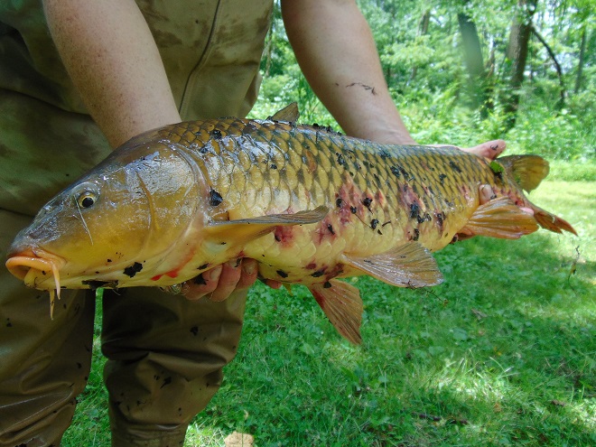
We came across this photo from a dive we did back in 1999 and thought it timely. Here a large non-native Common Carp churns up a cloud of nutrient-charged sediment as it roots its way through a bed of American Eelgrass and Water Stargrass in the Susquehanna below Conewago Falls. (Vintage 35 mm image)
One of the earliest non-native fish species to be widely released into North American waterways was the Common Carp. Stocks brought to the United States were likely sourced from populations already naturalized throughout much of western Europe after introductions originating from the fish’s native range in Eurasia, probably including the Danube and other watersheds east through the Volga. In western Europe, the species promised to be an abundant and easily cultivated food source. Under the same premise, carp were transported to the United States during the early 1800s and widely introduced into streams, lakes, and rivers throughout the country.
Common Carp thrive in nutrient-rich waters, particularly those subjected to sewage discharge and agricultural runoff, conditions which were already prevalent during the Common Carp’s initial introduction and have remained widespread ever since. Within these polluted streams, lakes, and ponds, introduced carp feed aggressively on benthic organisms and plants, stirring up decaying organic matter (mulm) from the substrate. This process raises turbidity in the water column and releases excessive amounts of the nutrient phosphorus resulting in unusually large algal blooms. Algal blooms can block sunlight from the longer-lived oxygen-producing vascular plants that grow in submerged environs. Growing beneath a dense cloud or blanket of algae can compromise the vigor of oxygen-producing vascular plants and disable their biochemical functions within the aquatic ecosystem. As the short-lived algae die, the bacteria that decay them begin to place increased oxygen demands on the water. With less oxygen being produced by both the vascular plants and the algae, and with oxygen consumption increased by the activity of decomposers, conditions can become fatal for fish and other organisms. This process is known as eutrophication. Because Common Carp are among the species most tolerant of eutrophic conditions, they tend to thrive in the conditions they create while the native fishes perish.
Common Carp spawn in the spring, usually from late April through June, when the water temperature is as low as 58 degrees and as high as 83 degrees Fahrenheit. This activity is often triggered by a rapid increase in water temperature. In a small lake, this may be brought on by a string of sunny days in late April or May. On larger streams and rivers, the temperature spike that initiates the spawn may not occur until warm rains and runoff enter the stream during June.
Seeing the exposed backs of Common Carp as they stir up mulm and other sediments while feeding along the edges of a body of water is not at all unusual.But carp pursuing other carp into the shallows is a sign that spawning has commenced.In water that is often less than a foot in depth, male carp follow the breeding females into egg-laying areas among debris and emergent vegetation.A fountain of splashes can ensue as males try to outdo one another for a chance to fertilize the female’s eggs.The males’ aggressive pursuit can even forced a large female to temporarily ground herself on the beach.
Common Carp are one of the most widely farmed and eaten fish in all the world. Here in the United States, they were introduced beginning two hundred years ago because they were favorable to the palate, grew to large size quickly, and were a source of much needed food. Today, the Common Carp is seldom found on the American dinner plate. Yet, pound for pound, it is one of the most abundant fish in many of our waters, particularly in man-made lakes. Like some of our other most invasive species—including Blue Catfish, Flathead Catfish, and Northern Snakehead—Common Carp are perhaps the most edible of our freshwater fishes. For many cultures, they are an important staple. For others, they are a delicacy or holiday treat. In America, they do horrendous damage to aquatic ecosystems following establishment as a food crop that almost never gets harvested. Did you realize that on the internet, there are literally hundreds of recipes and culinary videos available to show you how to prepare delicious dishes made with Common Carp? It’s true. And for the cost of a fishing license, you can catch all you want, usually several pounds at a time. So why not give the marine fisheries a break? Take the big leap and learn to eat invasive freshwater species instead.
With temperatures finally climbing to seasonable levels and with stormy sun filtering through the yellow-brown smoke coming our way courtesy of wildfires in Alberta and other parts of central Canada, we ventured out to see what might be basking in our local star’s refracted rays…
Dragonflies including this Black Saddlebags are now actively patrolling the edges of waterways and wetlands for prey and mates.Here we see a pair of Common Green Darners flying in tandem……and, having already mated, stopping at a suitable location for the female to oviposit the fertilized eggs onto submerged plant stems.A sunny day almost always brings out the reptiles, including these Painted Turtles…and the invasive Red-eared Slider, a native transplant from the American midwest.A really big Snapping Turtle will prey on almost anything, including other Snapping Turtles……but this one seems to be fascinated by something a lot smaller. Something like these juvenile Golden Shiners seen here schooling in the sun-drenched shallows.Turtles aren’t the only reptiles thriving in the heat. Northern Water Snakes (Nerodia sipedon sipedon) take full advantage of a sun-drenched rock to warm up after spending time in the chilly water of a stream.You know, no one loves a snake like another snake……and when it comes to these two snakes, it looks like love is in the air!Butterflies like this Spicebush Swallowtail enjoy time in the sun, even while seeking out minerals in a patch of moist soil.After its siblings darted into the familial burrow upon our approach, this juvenile Woodchuck instead sought the attention of its nurturing mother. Unlike its brothers and sisters, perhaps this little groundhog isn’t afraid of its own shadow. Or does the smoky haze have the youngster all confused about what does and doesn’t constitute as a shadow? Well, we can’t help you there, but you have a whole eight months to figure it out!
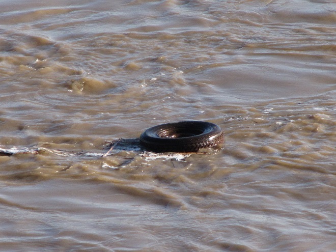
The deluge of rain that soaked the lower Susquehanna watershed during last week is now just a memory. Streams to the west of the river, where the flooding courtesy of the remnants of Hurricane Debby was most severe, have reached their crest and receded. Sliding away toward the Chesapeake and Atlantic is all that runoff, laden with a brew of pollutants including but not limited to: agricultural nutrients, sediment, petroleum products, sewage, lawn chemicals, tires, dog poop, and all that litter—paper, plastics, glass, Styrofoam, and more. For aquatic organisms including our freshwater fish, these floods, particularly when they occur in summer, can compound the effects of the numerous stressors that already limit their ability to live, thrive, and reproduce.
(Environmental Protection Agency image)
One of those preexisting stressors, high water temperature, can be either intensified or relieved by summertime precipitation. Runoff from forested or other densely vegetated ground normally has little impact on stream temperature. But segments of waterways receiving significant volumes of runoff from areas of sun-exposed impervious ground will usually see increases during at least the early stages of a rain event. Fortunately, projects implemented to address the negative impacts of stormwater flow and stream impairment can often have the additional benefit of helping to attenuate sudden rises in stream temperature.
While a row of trees along a creek can help provide protection from the thermal impact of the sun, a vegetative riparian buffer must be much wider to be effective for absorbing, cooling, and treating runoff from fields, lawns, and paved surfaces. This buffer is too narrow to prevent surface runoff from polluting the water.
Of the fishes inhabiting the Lower Susquehanna River Watershed’s temperate streams, the least tolerant of summer warming are the trouts and sculpins—species often described as “coldwater fishes”. Coldwater fishes require water temperatures below 70° Fahrenheit to thrive and reproduce. The optimal temperature range is 50° to 65° F. In the lower Susquehanna valley, few streams are able to sustain trouts and sculpins through the summer months—largely due to the effects of warm stormwater runoff and other forms of impairment.
Sculpins, including the Blue Ridge Sculpin (Cottus caeruleomentum) seen here, are native coldwater fishes which, during the 11,000 years since the last glacial maximum, have had the availability of their favored habitat sharply reduced by warming water temperatures and a rising Atlantic. During this interval, seawater has inundated the path of the “Late” Pleistocene lower Susquehanna which passed through the section of flooded river watershed we now call Chesapeake Bay and continued across the continental shelf to what was, during the glacial maximum, the river’s mouth at Norfolk Canyon. Today, cut off from neighboring drainage basins, sculpins survive exclusively in cold headwaters, and only in those where human alterations including pollution, dams, channelization, and reduced base flow haven’t yet eliminated their isolated populations. Formerly believed to be composed of two widespread North American species, the Slimy Sculpin (Cottus cognatus) and the Mottled Sculpin (Cottus bairdii), study in recent decades is discovering that sculpin populations in the present-day lower Susquehanna and neighboring Potomac headwaters consist of at least three newly delineated species: Blue Ridge Sculpin, Potomac Sculpin (Cottus gerardi), and Checkered Sculpin (Cottus sp.), the latter an as yet undescribed species found only in the refugium of limestone springs in the Potomac drainage in West Virginia; Frederick and Washington Counties, Maryland; and Franklin County, Pennsylvania. (United States Geological Survey image)Stare at this for a little while, you’ll figure it out…………More than 11,000 years ago, during the end of the last glacial period, when sea level was about 275 feet lower than it is today, there was no Chesapeake Bay, just a great Susquehanna River that flowed to the edge of the continental shelf and its mouth at Norfolk Canyon. It was a river draining taiga forests of pine, spruce , and fir, and it carried along the waters of all the present-day bay’s tributaries and more. The section of the river’s watershed we presently call the lower Susquehanna was, at the time, the upper Susquehanna watershed. Brook Trout and sculpins had the run of the river and its tributaries back then. And the entire watershed was a coldwater fishery, with limestone and other groundwater springs providing not refuge from summer heat, but a place to escape freezing water. (United States Geological Survey base image)Norfolk Canyon, the mouth of the Susquehanna River during the most recent glacial maximum, now lies more than 275 feet below the surface of the ocean and plunges to more than a mile in depth along the finger of out wash from the gorge. (United States Geological Survey image)Tens of thousands of trout are raised in state-operated and cooperative nurseries for stocking throughout the lower Susquehanna valley. These rearing facilities are located on spring-fed headwaters with sufficient flow to assure cold temperatures year round. While the Rainbow Trout and Brown Trout (Salmo trutta) are the most commonly stocked species, the Brook Trout (Salvelinus fontinalis) is the only one native to American waters. It is the least tolerant of stream warming and still reproduces in the wild only in a few pristine headwaters streams in the region. During spring, all three of these species have been observed on rare occasions entering the fish lift facilities at the hydroelectric dams on the river, presumably returning to the Susquehanna as sea-run trout.
Coldwater fishes are generally found in small spring-fed creeks and headwaters runs. Where stream gradient, substrate, dissolved oxygen, and other parameters are favorable, some species may be tolerant of water warmer than the optimal values. In other words, these temperature classifications are not set in stone and nobody ever explained ichthyology to a fish, so there are exceptions. The Brown Trout for example is sometimes listed as a “coldwater transition fish”, able to survive and reproduce in waters where stream quality is exceptionally good but the temperature may periodically reach the mid-seventies.
The Eastern Blacknose Dace is sometimes classified as a “coldwater transition fish”. It can be found in headwaters runs as well as in creeks with good water quality.The Longnose Dace is another “coldwater transition fish” known only from clear, clean, flowing waters.
More tolerant of summer heat than the trouts, sculpins, and daces are the “coolwater fishes”—species able to feed, grow, and reproduce in streams with a temperature of less than 80° F, but higher than 60° F. Coolwater fishes thrive in creeks and rivers that hover in the 65° to 70° F range during summer.
The Creek Chub is a familiar species of “coolwater fish” seldom found remaining in waters exceeding 80 degrees Fahrenheit.The Yellow Perch (Perca flavescens) was perhaps the most frequently targeted coolwater “gamefish” in the Lower Susquehanna River Watershed prior to the introduction of the Northern Pike (Esox lucius) and Muskellunge (Esox masquinongy). Today’s prevalence of warmwater streams and the dozens of species of non-native predatory fishes now naturalized within them have left the Yellow Perch populations greatly reduced and all but forgotten by anglers. Out of sight, out of mind. (National Park Service image)
What are the causes of modern-day reductions in coldwater and coolwater fish habitats in the lower Susquehanna River and its hundreds of miles of tributaries? To answer that, let’s take a look at the atmospheric, cosmic, and hydrologic processes that impact water temperature. Technically, these processes could be measured as heat flux—the rate of heat energy transfer per unit area per unit time, frequently expressed as watts per meter squared (W/m²). Without getting too technical, we’ll just take a look at the practical impact these processes have on stream temperatures.
HEAT FLUX PROCESSES IN A SEGMENT OF STREAM
Heat Flux Processes on Stream and River Segments. These processes could be measured as heat flux—the rate of heat energy transfer per unit area per unit time. (Environmental Protection Agency image)
INCOMING TEMPERATURE AND FLOW—The baseline temperature of stream water entering a given segment of waterway is obviously the chief factor determining its temperature when exiting that segment. Incoming temperature and flow also determine the water’s susceptibility to heat absorption or loss while transiting the segment. Lower flows may subject the given volume of water to a greater loss or gain of heat energy during the time needed to pass through the segment than the same volume at a higher flow. Lower flows may also reduce stream velocity and extend a given volume of water’s exposure time to the exchange of heat energy while moving through the segment. Generally speaking…
…the higher the stream flow, the less a given volume of that stream’s water may be impacted by the effects of the heat flux processes within the segment.
…the lower the stream flow, the more a given volume of that stream’s water may be impacted by the effects of the heat flux processes within that segment.
…the temperature and flow rate of precipitation entering the segment are factors that determine the impact of its heat energy transfer to or from a given volume of the stream’s waters.
…the temperature and flow rate of runoff and point-source discharges entering the segment are factors that determine the impact of their heat energy transfer to or from a given volume of the stream’s waters.
Stormwater from impervious surfaces including roads, parking lots, roofs, and lawns quickly impacts temperatures in small creeks. Channelized streams are availed few of the positive attributes provided by many of the heat flux processes we’re about to see. They therefore suffer from severe impairment and are exposed to temperature extremes that few aquatic organisms can survive. Runoff from sun-heated pavement during a summer thunderstorm can often exceed 100 degrees Fahrenheit and can, at sufficient flow rate, quickly raise the temperature of a small stream to well over 90 degrees.Stormwater runoff not only poses a thermal threat to waterways, its a significant source of a wide variety of pollutants.
GROUNDWATER INPUT—In streams connected to the aquifer, the temperature in a flowing segment can be impacted by the influx of cold groundwater. With temperatures ranging from about 52° to 60° Fahrenheit, groundwater will absorb heat from the stream in summer, and warm it in the winter. In warmwater streams, coldwater and coolwater fishes will often seek areas of the substrate where groundwater is entering for use as refugium from the summer heat. Yellow Perch in the lower Susquehanna are known to exhibit this behavior.
Creeks and rivers connected to the aquifer and receiving supplemental flow from it are known as “gaining streams”. These streams frequently feed water into the aquifer as well. (United States Geological Survey image)When flowing through an area experiencing drought or an excessive removal of groundwater (lots of wells, etc.), a waterway can become a “losing stream”, one that surrenders a portion of its flow to recharge the aquifer. Further downstream, the reduced flow can make such a creek or river more susceptible to the effects of heat flux processes. (United States Geological Survey image)Seriously depleted aquifers can lead to a “disconnected stream”. Smaller waterways subjected to these conditions will sometimes lose all their flow to the ground, often causing a catastrophic failure of the aquatic ecosystem supported therein. (United States Geological Survey image)Urban runoff overwhelms this small stream with polluted water than can reach temperatures of 100 degrees or more (left), then lets it high and dry with no baseflow during periods of dry weather (right) as the waterway becomes disconnected from the much-depleted aquifer.Well-designed and properly constructed stormwater retention basins not only recharge groundwater supplies for wells and streams, they can also help prevent thermal pollution in waterways. Planted with native wetland species and allowed to thrive, they can become treasured wildlife islands in otherwise inhospitable environs. The benefits don’t stop there; plants also help sequester nutrients contained in the runoff.
HYPORHEIC EXCHANGE—Related to groundwater input, hyporheic exchange is the slow movement of water through the rock, sand, gravel, and soils composing the streambed, saturated shoreline, shallow aquifer, and connected floodplain of a creek or river. As a heat flux process, hyporheic exchange helps moderate extremes in seasonal water temperatures by conducting energy between the solid materials in the zone and the flowing water. Hyporheic zones are important habitats for many species of aquatic invertebrates and spawning fish. Natural chemical processes within these zones convert ammonia-producing wastes into nitrite, then nitrate, allowing it to be absorbed as food by plants growing in the stream or in the alluvium within the zone. Vegetation removal, channelization, legacy sediments, silt deposits, and man-made walls and dams can negate the benefits of hyporheic exchange.
Exchange of surface and ground water within the hyporheic zone is most directly associated with high-gradient (left) and meandering (right) segments of streams. (United States Geological Survey image)Very common on streams in the lower Susquehanna valley are these accumulations of legacy sediments at the sites of former mill ponds. After the dams were removed, the creeks began eroding their way down through the mire as they tried to reestablish their floodplains and find their native substrate. These trapped waterways are not only cut off from their hyporheic zones, they’re now a major source of nutrient and sediment pollution. Misguided landowners like this one frequently dump fill into these sites to “save their land” and “control flooding”. The fill and materials added to “shore up the banks” do nothing to fix what ails the creek, but instead displace more water to make the impact of flooding even more widespread.Rehabilitation projects that remove legacy sediments help restore hyporheic exchange by reconnecting the stream to its underlying geology, its floodplain, and its wetlands. Rising waters remain in the floodplain where they get a good bio-scrubbing and help replenish the creek and groundwater supply. As the experts say, “floodplains are for flooding.”
ATMOSPHERIC EXCHANGE (CONVECTION, EVAPORATION)—Primarily a process by which a stream loses heat energy and cools its waters, atmospheric exchange is also a means by which a warm air mass can relinquish heat to cooler waters and thus increase their temperature. This phenomenon can be dramatically enhanced when a stream passes through a so-called urban heat island where air temperatures remain warm through the night. Convection, the movement of heat energy through a fluid (liquid or gas), causes warmer, less-dense water to rise to the surface of a stream, particularly where there is minimal turbulence. When the air above is cooler than the water’s surface layer, the stream will conduct heat energy across the water/atmosphere interface causing the warmed air molecules to rise in a convection column. If the atmospheric relative humidity is less than 100%, some surface water will vaporize—a process that expends more of the stream’s heat energy. The rate of convective and evaporative cooling in a given stream segment is directly related to the degree of difference between the water temperature and air temperature, and to the relative humidity in the air mass above the lake, creek, or river. The mechanical action of stream turbulence including rapids, riffles, and falls increases the contact area between air and water to maximize the atmospheric exchange of heat energy. The convective air current we call surface wind has a turbulent wave-producing effect on water that can also maximize atmospheric exchange; think of a cold autumn wind robbing heat energy from a warm lake or river or a hot summer wind imparting its heat to a cooler creek. These exchanges are both conductive in nature (air-to-water/water-to-air) and evaporative, the latter being expedited by the movement of dry air over warm water.
Usually classified as one of the coolwater fishes, the bottom-dwelling Tessellated Darter can thrive in the warmer creeks and in the main stem of the Susquehanna by inhabiting riffles where atmospheric exchange in the form of increased evaporation helps reduce temperatures and convective currents carry the cooler, well-oxygenated water to the streambed.Humans utilize the concept of atmospheric exchange, adopting the phenomena of evaporation and convection to cool the hot waters produced during electric generation and other industrial processes before discharge into a lake or river.
STREAMBED CONDUCTIVE EXCHANGE—In the lower Susquehanna watershed, there may be no better natural example of streambed conductive exchange than the Triassic-Jurassic diabase pothole bedrocks of Conewago Falls on the river at the south end of Three Mile Island.
During sunny days, the massive diabase pothole rocks at Conewago Falls absorb solar (shortwave) radiation, then conduct that heat energy into the flowing water, often continuing to pass the accumulated warmth into the river during the night. On cloudy days, the riverbed collects longwave atmospheric radiation, a heat flux process that yields significantly less energy for conduction into the rapids, riffles, and pools of the falls. During periods of low river flow, the heating effect of streambed conductive exchange can become magnified. Compared to conditions that prevail when torrents of turbid water are rushing through the falls, partially exposed bedrock surrounded by clear water collects radiated energy much more efficiently, then conducts the heat to a greatly reduced volume of passing water. During summer and autumn, this process can create a mix of temperature zones within the falls with warmer water lingering in slow-moving pools and cooler water flowing in the deeper fast-moving channels. Along the falls’ mile-long course, a haven is created for aquatic organisms including warmwater and some coolwater fishes, oft times attracting anglers and a variety of hungry migrating birds as well.Classified as one of our coolwater fishes, the Fallfish finds favorable conditions for feeding, growing, and spawning in the well-oxygenated waters of Conewago Falls.Though the lower Susquehanna River is classified as a warmwater fishery, the Northern Hog Sucker (Hypentelium nigricans), another of our native coolwater fishes, finds the fast-moving waters of Conewago Falls to its liking. Northern Hog Suckers are known to inhabit streams cold enough to host trout. They exhibit remarkable home range fidelity, sometimes spending their entire lives occupying the same several hundred feet of waterway. Northern Hog Suckers are often designated an indicator of good water quality, intolerant of many stream impairment parameters. Their presence in Conewago Falls provides testament to the quality of the warmwater fishery there.An unnatural example. The reduced base flow in this channelized and severely impaired creek has been rendered vulnerable to the negative impacts of several heat flux processes including streambed conductive exchange. Urban stormwater/surfacewater inflow, solar (shortwave) radiation, and heat conducted into the stream from the masonry walls, curbs, and raceway can all conspire to cook aquatic organisms with life-quenching summer water temperatures exceeding 90 degrees Fahrenheit.
SOLAR (SHORTWAVE) RADIATION—The sun provides the energy that fuels the earth’s complex climate. The primary heat flux process that heats our planet is the absorption of solar radiation in the shortwave spectrum, which includes ultraviolet, visible, and infrared frequencies at the upper end of the longwave spectrum. Streams and other bodies of water absorb the greatest amounts of solar (shortwave) radiation during the weeks around summer solstice when the sun at mid-day is closer to zenith than at any other time of the year. However, the heating impact of the radiation may be greatest when the volume of water in the creek, river, or lake is at its minimum for the year—often during early fall.
The rate, measured in watts per square meter, at which solar (shortwave) energy is directly radiated to a given area on the earth’s surface (including streams and other waters) is determined by: solar activity, the angle of the sun in the sky, aspect (slope) of the receiving surface, the opacity of the overlying atmosphere, and the distance of the earth from the sun. The former varies with the year’s seasons, the time of day, and the latitude of a given area. The latter is currently at its annual minimum when earth is at perihelion during the early days of January, thus providing the northern hemisphere with a little bump in radiation during the shortest days of the year when the sun is at its lowest angle in the sky. (NASA image)A varying portion of the solar (shortwave) radiation reaching the earth is reflected back into space by clouds. A smaller share is absorbed by the atmosphere, thus heating it. An even lesser quantity is reflected back into space by water and land. The remainder of the energy is absorbed by the planet’s surfaces, its water and land. (NASA image)
INCIDENT SHORTWAVE RADIATION—Also known as insolation (incoming solar radiation), incident shortwave radiation is the sum total energy of both the direct solar radiation that travels to the earth’s surface unaffected by the atmosphere and the diffuse radiation, waves that have been weakened and scattered by constituents of the atmosphere before reaching the planet’s surface. On a cloudy day, the warming of terrestrial surfaces including streams and other bodies of water is the result of diffuse radiation. On days with any amount of sunshine at all, both direct and diffuse radiation heat our waters and lands.
Warmwater fishes such as the native Pumpkinseed (Lepomis gibbosus) thrive in sun-drenched 70-to-85-degree waters as long as other heat flux processes prevent sudden temperature increases and oxygen depletion.Mowed stream banks offer a waterway no protection from incoming solar (shortwave) radiation, nor terrestrial forms of impairment including nutrient-rich stormwater runoff and silt.
REFLECTED SHORTWAVE RADIATION—known as albedo, reflected solar (shortwave) radiation is energy directed away from the earth’s surface before being absorbed. A surface’s albedo value is basically determined by its color, black having little reflective value, white and silvery surfaces reflecting nearly all solar (shortwave) radiation away. A surface with no reflective properties has an albedo value of 0, while a totally reflective surface has a value of 1. Clean snow with a value of about 0.85 to 0.9 (85% to 90%) is a highly reflective surface; yellow snow isn’t as good. A stream, river, or lake blanketed with ice and snow will absorb very little solar energy and will rely upon other heat flux processes to trigger a melt and thaw. The surface of open water has a varying albedo value determined mostly by the angle of the sun. Solar radiation striking the water’s surface at a low angle is mostly reflected away, while that originating at an angle closer to zenith is more readily absorbed.
To avoid the heating effects of solar (shortwave) and atmospheric longwave radiation, coldwater and coolwater fishes require streams offering protection from full exposure to direct sunlight and cloud cover. Runs and creeks flowing beneath a closed canopy of forest trees are shielded from 25% or more of incoming radiation and are thus able to better maintain thermal stability during the most vulnerable period of the year for temperature-sensitive fishes, May through October.
LONGWAVE RADIATION—Radiation in the longwave spectrum is composed of infrared waves at frequencies lower than those of the shortwave spectrum. Longwave radiation, sometimes just called infrared radiation, is produced by the earth and its atmosphere and is propagated in all directions, day and night. It warms mostly the lower atmosphere which in turn warms the earth’s surface including its waters. Some longwave energy can even be radiated into the waterway from its own streambed—and the stream can return the favor. Other forms of mass surrounding a stream such as a rocky shoreline or a man-made structure such as bridge pier can trade longwave radiation with a waterway. The effect of these latter exchanges is largely trivial and never rivals the heat flux transfer of warm to cold provided by conduction.
Longwave radiation emissions slow as the temperature of the emitting mass decreases, just as they also increase with temperature of the mass. Longwave radiation emissions therefore decrease with altitude along with the temperature of the water vapor, carbon dioxide, methane, and other gases that produce them. As such, the highest reaches of the atmosphere have a greatly reduced capability of shedding longwave radiation into space. At ground level, lakes, creeks, and streams receive their greatest dose of longwave radiation while beneath the cover of low-lying clouds or fog. (NASA image)
CANOPY RADIATION—Trees emit longwave radiation that may have a limited heat flux impact on waterway temperature. This radiation is diffuse, of scattered effect, and scarcely detectable, particularly beneath multilayered dense canopies. Some of the infrared energy transmitted by the tree canopy is radiated skyward as well.
WATER RADIATION—Water, like all earthly matter composed of vibrating molecules, emits longwave radiation. This heat flux process provides an ongoing cooling effect to streams, rivers, lakes, and oceans—warmer ones shedding infrared energy at a faster rate than those that are cold.
Now that we have a basic understanding of the heat flux processes responsible for determining the water temperatures of our creeks and rivers, let’s venture a look at a few graphics from gauge stations on some of the lower Susquehanna’s tributaries equipped with appropriate United States Geological Survey monitoring devices. While the data from each of these stations is clearly noted to be provisional, it can still be used to generate comparative graphics showing basic trends in easy-to-monitor parameters like temperature and stream flow.
Each image is self-labeled and plots stream temperature in degrees Fahrenheit (bold blue) and stream discharge in cubic feet per second (thin blue).
The West Conewago Creek drains much of the Gettysburg Basin’s Triassic redbeds in Adams and northern York Counties in Pennsylvania and includes a small headwaters area in northern Maryland. The gauge station is located just a over a mile upstream from the waterway’s mouth on the Susquehanna just below Conewago Falls. Right through the summer heatwave, this 90-day graph shows a consistent daily pattern of daytime rises in temperature and nighttime cooling. To the right, a rapid cool down can be seen coinciding with two periods of high water, the first from a series of heavy thundershowers, the second from flooding caused by the remnants of Hurricane Debby. Notice that the early August downpours were so heavy that they cooled the hot surface runoff and waterway quickly, without creating a rise in stream temperature at the gauging station. Had this monitoring device been located on a small tributary in an area with an abundance of impervious surfaces, there would probably have been a brief rise in stream temperature prior to the cooldown. (United States Geological Survey image)
The daily oscillations in temperature reflect the influence of several heat flux processes. During the day, solar (shortwave) radiation and convection from summer air, especially those hot south winds, are largely responsible for the daily rises of about 5° F. Longwave radiation has a round-the-clock influence—adding heat to the stream during the day and mostly shedding it at night. Atmospheric exchange including evaporative cooling may help moderate the rise in stream temperatures during the day, and certainly plays a role in bringing them back down after sunset. Along its course this summer, the West Conewago Creek absorbed enough heat to render it a warmwater fishery in the area of the gauging station. The West Conewago is a shallow, low gradient stream over almost its entire course. Its waters move very slowly, thus extending their exposure time to radiated heat flux and reducing the benefit of cooling by atmospheric exchange. Fortunately for bass, catfish, and sunfish, these temperatures are in the ideal range for warmwater fishes to feed, grow, and reproduce—generally over 80° F, and ideally in the 70° to 85° F range. Coolwater fishes though, would not find this stream segment favorable. It was consistently above the 80° F maximum and the 60° to 70° F range preferred by these species. And coldwater fishes, well, they wouldn’t be caught dead in this stream segment. Wait, scratch that—the only way they would be caught in this segment is dead. No trouts or sculpins here.
The Codorus Creek drains primarily the carbonate valleys of York County to the south of the West Conewago watershed. This gauge station is located about a mile upstream from the creek’s mouth on the Susquehanna just below Haldeman Riffles. The graphic pattern is very similar to that of the West Conewago’s: daily heating and cooling cycles and a noticeable drop in stream temperature in early August caused by a day of thundershowers followed by the remnants of Hurricane Debby. (United States Geological Survey image)
Look closely and you’ll notice that although the temperature pattern on this chart closely resembles that of the West Conewago’s, the readings average about 5 degrees cooler. This may seem surprising when one realizes that the Codorus follows a channelized path through the heart of York City and its urbanized suburbs—a heat island of significance to a stream this size. Before that it passes through numerous impoundments where its waters are exposed to the full energy of the sun. The tempering factor for the Codorus is its baseflow. Despite draining a smaller watershed than its neighbor to the north, the Codorus’s baseflow (low flow between periods of rain) was 96 cubic feet per second on August 5th, nearly twice that of the West Conewago (51.1 cubic feet per second on August 5th). Thus, the incoming heat energy was distributed over a greater mass in the Codorus and had a reduced impact on its temperature. Though the Codorus is certainly a warmwater fishery in its lower reaches, coolwater and transitional fishes could probably inhabit its tributaries in segments located closer to groundwater sources without stress. Several streams in its upper reaches are in fact classified as trout-stocked fisheries.
This is a zoomed-in look at the previous graph showing the impact of a rainfall event on the water temperatures in Codorus Creek. Unlike the sharp declines accompanying the deluge of flood waters during the two events in early August, these lesser storms in late June generated just enough runoff to capture heat energy from impervious surfaces and warm the creek, temporarily breaking the daily heating/cooling cycle. Upstream in the immediate area of the runoff, the impact on the stream and/or its tributaries was probably much more dramatic, certainly raising temperatures into the nineties or above. (United States Geological Survey image)Kreutz Creek drains a carbonate bedrock area of York County and flows parallel to the Lincoln Highway (US 30) to enter the Susquehanna at Wrightsville. The gauging station is about one mile upstream from the creek’s mouth. (United States Geological Survey image)
The Kreutz Creek gauge shows temperature patterns similar to those in the West Conewago and Codorus data sets, but notice the lower overall temperature trend and the flow. Kreutz Creek is a much smaller stream than the other two, with a flow averaging less than one tenth that of the West Conewago and about one twentieth of that in the Codorus. And most of the watershed is cropland or urban/suburban space. Yet, the stream remains below 80° F through most of the summer. The saving graces in Kreutz Creek are reduced exposure time and gradient. The waters of Kreutz Creek tumble their way through a small watershed to enter the Susquehanna within twenty-four hours, barely time to go through a single daily heating and cooling cycle. As a result, their is no chance for water to accumulate radiant and convective heat over multiple summer days. The daily oscillations in temperature are less amplified than we find in the previous streams—a swing of about three degrees compared to five. This indicates a better balance between heat flux processes that raise temperature and those that reduce it. Atmospheric exchange in the stream’s riffles, forest cover, and good hyporheic exchange along its course could all be tempering factors in Kreutz Creek. From a temperature perspective, Kreutz Creek provides suitable waters for coolwater fishes.
Muddy Creek drains portions of southern York County through rolling farmland and woodlots. There are no large impoundments or widespread urban impacts in the watershed, which may help explain its slightly lower temperature trends. (United States Geological Survey image)
Muddy Creek is a trout-stocked fishery, but it cannot sustain coldwater species through the summer heat. Though temperatures in Muddy Creek may be suitable for coolwater fishes, silt, nutrients, low dissolved oxygen, and other factors could easily render it strictly a warmwater fishery, inhabited by species tolerant of significant stream impairment.
Chiques Creek drains mostly limestone farmland in northwestern Lancaster County. The gauging station is located near the stream’s mouth on the Susquehanna at Chiques (Chickies) Rock. Oscillations in temperature again resemble the other waterways, but daily highs remain almost entirely below 80 degrees. (United States Geological Survey image)
A significant number of stream segments in the Chiques watershed have been rehabilitated to eliminate intrusion by grazing livestock, cropland runoff, and other sources of impairment. Through partnerships between a local group of watershed volunteers and landowners, one tributary, Donegal Creek, has seen riparian buffers, exclusion fencing, and other water quality and habitat improvements installed along nearly ever inch of its run from Donegal Springs through high-intensity farmland to its mouth on the main stem of the Chiques just above its confluence with the Susquehanna. The improved water quality parameters in the Donegal support native coldwater sculpins and an introduced population of reproducing Brown Trout. While coldwater habitat is limited to the Donegal, the main stem of the Chiques and its largest tributary, the Little Chiques Creek, both provide suitable temperatures for coolwater fishes.
Streams in the Chiques Creek and similar limestone watersheds often pass through areas with significant bedrock formations. Heat flux processes including groundwater input, hyporheic exchange, and streambed conductive exchange can have a greater influence on water temperature along these segments.A breeding condition Eastern Balcknose Dace, one of the coldwater transition fishes found in the Chiques and its tributaries.The Common Shiner (Luxilus cornutus), a fish tolerant of warmwater streams, prefers cool, clear waters for spawning. For protection from late-spring and summer heat, breeding males may seek a section of creek with a streambed inflow of limestone groundwater to defend as their nesting territory.A closeup of the Chiques Creek graph showing what appears to be a little bump in temperature caused by surface runoff during a couple of late-May showers. Stream rehabilitation is an ongoing process and the pressures of land disturbances both old and new present challenges to those who make it their passion to fix the wrongs that have been inflicted upon our local waters. Even the exemplary Donegal Creek faces new threats from urbanization in one of its headwater areas several miles to the northwest of the historic springs. (United States Geological Survey image)Conewago Creek (East) drains primarily Triassic redbed farmlands in Dauphin, Lancaster, and Lebanon Counties. Much of the headwaters area is forested but is experiencing an increasing rate of encroachment by housing and some commercial development. Conewago Creek (East) enters the Susquehanna on the east side of Conewago Falls at Three Mile Island. The watershed is equipped with three U.S.G.S. gauge stations capable of providing temperature data. This first one is located just over a mile upstream of the creek’s mouth. (United States Geological Survey image)
Despite its meander through and receipt of water from high-intensity farmland, the temperature of the lower Conewago (East) maxes out at about 85° F, making it ideal for warmwater fishes and even those species that are often considered coolwater transition fishes like introduced Smallmouth Bass, Rock Bass, Walleye, and native Margined Madtom. This survivable temperature is a testament to the naturally occurring and planted forest buffers along much of the stream’s course, particularly on its main stem. But the Conewago suffers serious baseflow problems compared to other streams we’ve looked at so far. Just prior to the early August storms, flow was well below 10 cubic feet per second for a drainage area of more than fifty square miles. While some of this reduced flow is the result of evaporation, much of it is anthropogenic in origin as the rate of groundwater removal continues to increase and a recent surge in stream withdraws for irrigation reaches its peak during the hottest days of summer.
A juvenile Rock Bass.A juvenile Margined Madtom.A closer look at the Conewago Creek (East) graphic shows the temperature drop associated with a series of thundershowers and the remnants of Hurricane Debby in early August. Despite the baseflow being below five cubic feet per second, the cooling effect of the downpours as measured in the area of the gauge was significant enough to overwhelm any heating of runoff that may have occurred as precipitation drained across hardened soils or man-made impervious surfaces. (United States Geological Survey image)
A little side note—the flow rate on the Conewago at the Falmouth gauge climbed to about 160 cubic feet per second as a result of the remnants of Hurricane Debby while the gauge on the West Conewago at Manchester skyrocketed to about 20,000 cubic feet per second. Although the West Conewago’s watershed (drainage area) is larger than that of the Conewago on the east shore, it’s larger only by a multiple of two or three, not 125. That’s a dramatic difference in rainfall!
The Bellaire monitoring station on Conewago Creek (East) is located on the stream’s main stem just downstream from the mouth of Little Conewago Creek, a tributary with its origins in farmland and woodlots. (United States Geological Survey image)
The temperatures at the Bellaire monitoring station, which is located upstream of the Conewago’s halfway point between its headwaters in Mount Gretna and its mouth, are quite comparable to those at the Falmouth gauge. Although a comparison between these two sets of data indicate a low net increase in heat absorption along the stream’s course between the two points, it also suggests sources of significant warming upstream in the areas between the Bellaire gauge and the headwaters.
Data from the gauge site on the Little Conewago Creek shows a temperature averaging about five degrees cooler than the gauge several miles downstream on the main stem of the Conewago at Bellaire. (United States Geological Survey image)
The waters of the Little Conewago are protected within planted riparian buffers and mature woodland along much of their course to the confluence with the Conewago’s main stem just upstream of Bellaire. This tributary certainly isn’t responsible for raising the temperature of the creek, but is instead probably helping to cool it with what little flow it has.
A stream like the Little Conewago Creek with daily temperatures that remain mostly below 80 degrees and retreat to 75 degrees or less during the night can be suitable for coldwater transition fishes like these juvenile Eastern Blacknose Dace (top) and Longnose Dace.
Though mostly passing through natural and planted forest buffers above its confluence with the Little Conewago, the main stem’s critically low baseflow makes it particularly susceptible to heat flux processes that raise stream temperatures in segments within the two or three large agricultural properties where owners have opted not to participate in partnerships to rehabilitate the waterway. The headwaters area, while largely within Pennsylvania State Game Lands, is interspersed with growing residential communities where potable water is sourced from hundreds of private and community wells—every one of them removing groundwater and contributing to the diminishing baseflow of the creek. Some of that water is discharged into the stream after treatment at the two municipal sewer plants in the upper Conewago. This effluent can become quite warm during processing and may have significant thermal impact when the stream is at a reduced rate of flow. A sizeable headwaters lake is seasonally flooded for recreation in Mount Gretna. Such lakes can function as effective mid-day collectors of solar (shortwave) radiation that both warms the water and expedites atmospheric exchange.
The Conewago Creek (East) Watershed from the Bellaire U.S.G.S. Gauging Station (lower left) upstream to the headwaters in Mount Gretna. (United States Geological Survey image)
Though Conewago Creek (East) is classified as a trout-stocked fishery in its upper reaches in Lebanon County, its low baseflow and susceptibility to warming render it inhospitable to these coldwater fishes by late-spring/early summer.
Despite being considered a warmwater fish, the River Chub (Nocomis micropogon) will ascend streams like the Conewago to seek cooler, gravel-bottomed waters for spawning. Reduced baseflow has probably rendered the stream currently too small for this species on Pennsylvania State Game Lands in Colebrook where this specimen was photographed in 2018.The Golden Shiner, another warmwater fish, often ascends streams to enter cooler water. Juvenile Golden Shiners like this one will move into shallower headwaters not only to seek reduced temperatures, but to escape large predatory fishes as well.Irrigation of agricultural fields using a large portion of the already diminished baseflow in the Conewago Creek (East) just downstream of the Bellaire gauging station. Despite millions of dollars in investment to rehabilitate this Susquehanna valley stream, the riparian buffers and other practices can have little effect when the creek gets sucked down to just a trickle. Low baseflow is a hard nut to crack. It’s best prevented, not corrected.Hammer Creek, a trout-stocked fishery, originates, in part, within Triassic conglomerate in the Furnace Hills of Lebanon County, then flows north into the limestone Lebanon Valley where it picks up significant flow from other tributaries before working its way south back through the Furnace Hills into the limestone farmlands of Lancaster County. From there the stream merges with the Cocalico Creek, then the Conestoga River, and at last the Susquehanna. Note the tremendous daily temperature oscillations on this headwaters stream as it surges about 15 degrees each day before recovering back close to groundwater temperature by sunrise the next day. (United States Geological Survey image)Headwaters of Hammer Creek including Buffalo Springs, a significant source of cold groundwater feeding the western leg of the stream. The large dams on this section that created the Lebanon and Rexmont Reservoirs have been removed. (United States Geological Survey base image)
The removal of two water supply dams on the headwaters of Hammer Creek at Rexmont eliminated a large source of temperature fluctuation on the waterway, but did little to address the stream’s exposure to radiant and convective heat flux processes as it meanders largely unprotected out of the forest cover of Pennsylvania State Game Lands and through high-intensity farmlands in the Lebanon Valley. Moderating the temperature to a large degree is the influx of karst water from Buffalo Springs, located about two miles upstream from this gauging station, and other limestone springs that feed tributaries which enter the Hammer from the east and north. Despite the cold water, the impact of the stream’s nearly total exposure to radiative and other warming heat flux processes can readily be seen in the graphic. Though still a coldwater fishery by temperature standards, it is rather obvious that rapid heating and other forms of impairment await these waters as they continue flowing through segments with few best management practices in place for mitigating pollutants. By the time Hammer Creek passes back through the Furnace Hills and Pennsylvania State Game Lands, it is leaning toward classification as a coolwater fishery with significant accumulations of sediment and nutrients. But this creek has a lot going for it—mainly, sources of cold water. A core group of enthusiastic landowners could begin implementing the best management practices and undertaking the necessary water quality improvement projects that could turn this stream around and make it a coldwater treasure. An organized effort is currently underway to do just that. Visit Trout Unlimited’s Don Fritchey Chapter and Donegal Chapter to learn more. Better yet, join them as a volunteer or cooperating landowner!
The male Creek Chub, one of our coolwater fishes, develops head tubercles and becomes flushed with color during spawning season. Hammer Creek not only provides a home for the Creek Chub, its cold headwaters provide refuge for a population of native Brook Trout too.Like no other example we’ve looked at so far, this closeup of the Hammer Creek graphic shows temperature bumps correlating with the stormwater runoff from early August’s rains. Because the stream flow is small and the precipitation rate was not as great at this location, the effect of heat flux from runoff is more readily apparent. (United States Geological Survey image)Brook Trout adult and juvenile. (United States Fish and Wildlife Service image by Ryan Hagerty)
For coldwater fishes, the thousands of years since the most recent glacial maximum have seen their range slowly contract from nearly the entirety of the once much larger Susquehanna watershed to the headwaters of only our most pristine streams. Through no fault of their own, they had the misfortune of bad timing—humans arrived and found coldwater streams and the groundwater that feeds them to their liking. Some of the later arrivals even built their houses right on top of the best-flowing springs. Today, populations of these fishes in the region we presently call the Lower Susquehanna River Watershed are seriously disconnected and the prospect for survival of these species here is not good. Stream rehabilitation, groundwater management, and better civil planning and land/water stewardship are the only way coldwater fishes, and very possibly coolwater fishes as well, will survive. For some streams like Hammer Creek, it’s not too late to make spectacular things happen. It mostly requires a cadre of citizens, local government, project specialists, and especially stakeholders to step up and be willing to remain focused upon project goals so that the many years of work required to turn a failing stream around can lead to success.
Riparian buffers with fences to exclude livestock can immediately begin improving water quality. With establishment of such vegetative buffers, the effects of stressors that otherwise eliminate coldwater and coolwater fishes from these segments will begin to diminish.Within five to ten years, a riparian buffer planted with native trees is not only helping to reduce nutrient and sediment loads in the stream, it is also shielding the waters from heat flux processes including the solar (shortwave) radiation that raises water temperatures to levels not tolerated by coldwater and coolwater fishes.A well-established riparian buffer.A forested stream.
You’re probably glad this look at heat flux processes in streams has at last come to an end. That’s good, because we’ve got a lot of work to do.
Add one more benefit to the wildflower meadow, it infiltrates stormwater to recharge the aquifer much better than mowed grass. And another related plus, it reduces runoff and its thermal pollution. Besides, you don’t have time to mow grass, because we have work to do!Our native coldwater fishes including the Potomac Sculpin will survive only if we protect and expand the scattered few habitats where they have taken refuge. They have no choice but to live in these seriously threatened places, but we do. So let’s give ’em some space. How ’bout it? (United States Fish and Wildlife Service image by Ryan Hagerty)
Resilient to the pressures of flooding, ice scour, drought, and oft times really poor water quality, Water Willow (Dianthera americana, formerly Justicia americana) is the most common herbaceous plant on the Susquehanna’s non-forested alluvial islands. Yet, few know this native wildflower by name or reputation.
Pure stands of emergent Water Willow endure at times brutal conditions on non-forested islands in the Susquenanna.Alluvial deposits of sand, clay, gravel, and silt create ideal substrate for mats of Water Willow along shorelines of the Susquehanna and its larger tributaries. Provided the loose substrate remains moist, this emergent thrives even when water levels retreat during periods of dry weather. The woody plant in the background, the native Black Willow (Salix nigra), shares similar soil preferences but is found growing on slightly higher ground as a non-emergent tree or shrub. It is a member of the willow family (Salicaceae).In bloom now, the orchid-like flower of the Water Willow is a quick giveaway that it is not a close relative of the willow trees but is instead a member of the acanthus family (Acanthaceae) and is allied with the genus Ruellia, the wild petunias.
The spring of 2024 has been very kind to our beds of Water Willow. Rainfall in the Susquehanna watershed has been frequent enough to maintain river levels just high enough to keep the roots of the plants wet. During the interludes in storm activity, dry spells have rolled back any threat of flooding on the river’s main stem, thus eliminating chances of submerging the plants in muddy water and preventing the sun from keeping them warm, happy, and flowering early. Thundershowers throughout the basin earlier this week have now raised the river a few inches to inundate the base of the plants and make mats of Water Willow favorable places for newly hatched fry and other young fish to take refuge while they grow. Here’s a look…
The Spottail Shiner (Notropis hudsonius) is a common native minnow of the Susquehanna. This juvenile was found among several dozen small fish taking refuge in the cover of Water Willow below Conewago Falls.The Mimic Shiner (Notropis volucellus) is generally regarded to be a native transplant from the Mississippi drainage that has become established in the Susquehanna and many of its tributaries, possibly after introduction by way of bait buckets. However, the fish tends to be very fragile and dies quickly upon handling, so its use and transport as a bait species may be impractical. The Mimic Shiner is very common in around Conewago Falls.A juvenile Mimic Shiner less than one inch in length found among flooded Water Willow below Conewago Falls earlier this week.One of about a dozen juvenile Quillbacks (Carpiodes cyprinus) found in Water Willow just below Conewago Falls. For spawning, local populations of this compact native species of carpsucker favor the gravel-bottomed pools among the Jurassic-Triassic boulders of the falls’ pothole rocks. Probably hatched within the last eight weeks, this specimen was just one inch long.As summer progresses, stands of emergent Water Willow begin to expand their size by sending out rhizomes. Increasing numbers of small fish like this Spotfin/Satinfin Shiner (Cyprinella species) concentrate in the cover of the thickening vegetation.The importance of these patches of emergent wildflowers (sounds weird, doesn’t it?) is demonstrated by the numbers of fish gathered within their underwater forest of stems and leaves by summertime.To protect them from burial by silt and to prevent them from being swept away by current, spawning Spotfin/Satinfin Shiners deposit their eggs in crevices of submerged rocks and wood, often in or near mats of Water Willow. Males guard the eggs until hatching. The fry must then take shelter among boulders, cobble, and plant cover. Note the breeding-condition male in the upper right.Panfish like this non-native Green Sunfish (Lepomis cyanellus) will often choose nesting sites in deeper water adjacent to beds of Water Willow, particularly if submerged growth like this Water Stargrass adds to the availability of cover for their young after hatching.Smallmouth Bass gather in a pool adjacent to a Water Willow-covered island. These non-native predators rely on beds of these indigenous plants to provide habitat for their young, then, after spawning, lurk in the waters surrounding them to ambush less-than-vigilant minnows and other victims.
By now you’ve come to appreciate the importance of Water Willow to the sustainability of our populations of fish and other aquatic life. Like similar habitat features that reduce sediment runoff and nutrient pollution, undisturbed stands of terrestrial, emergent, and submerged native plant species are essential to the viability of our freshwater food webs.
First there was the Nautilus. Then there was the Seaview. And who can forget the Yellow Submarine? Well, now there’s the S. S. Haldeman, and today we celebrated her shakedown cruise and maiden voyage. The Haldeman is powered by spent fuel that first saw light of day near Conewago Falls at a dismantled site that presently amounts to nothing more than an electrical substation. Though antique in appearance, the vessel discharges few emissions, provided there aren’t any burps or hiccups while underway. So, climb aboard as we take a cruise up the Susquehanna at periscope depth to have a quick look around!
Brunner Island as seen from the east channel.Close-in approach to emergent Water Willow growing on an alluvial Island.The approach to York Haven Dam and Conewago Falls from the west channel.A pair of Powdered Dancers on a midriver log.
Watertight and working fine. Let’s flood the tanks and have a peek at the benthos. Dive, all dive!
American Eelgrass, also known as Tapegrass, looks to be growing well in the channels. Historically, vast mats of this plant were the primary food source for the thousands of Canvasback ducks that once visited the lower Susquehanna each autumn.As is Water Stargrass (Heteranthera dubia). When mature, both of these native plants provide excellent cover for young fish. Note the abundance of shells from deceased Asiatic Clams (Corbicula fluminea) covering the substrate.A three-tailed mayfly (Ephemeroptera) nymph and a several exoskeletons cling to the downstream side of a rock.This hollowed-out stick may be a portable protective shelter belonging to a Comb-lipped Casemaker Caddisfly larva (Calamoceratidae). The larva itself appears to be extending from the end of the “case” in the upper right of the image. Heteroplectron americanum, a species known for such behavior, is a possibility. In the Susquehanna and its tributaries, the Rusty Crayfish (Faxonius rusticus) is an introduced invasive species. It has little difficulty displacing native species due to its size and aggressiveness.A Rusty Crayfish.Summers with conditions that promote eelgrass and stargrass growth tend to be big years for Virginian River Horn Snails (Elimia virginica). 2022 appears to be one of those years. They’re abundant and they’re everywhere on the rocks and gravel substrate in midriver. Feeding almost incessantly on algae and detritus, these snails are an essential component of the riverine ecosystem, breaking down organic matter for final decomposition by bacteria and fungi.Bits of debris suspended in the flowing water streak by this Virginian River Horn Snail. The spire-shaped shell is a streamlining adaptation for maneuvering and holding fast in the strong current.A young Virginian River Horn Snail following a mature adult. Note the green algae growing among the decaying plant and animal remains that blanket the river bottom.Two of a population that may presently include millions of Virginian River Horn Snails living downstream of Conewago Falls.Virginian River Horn Snails with Lesser Mystery Snails (Campeloma decisum), another native species commonly encountered at Conewago Falls and in surrounding waters.A River Snail (Leptoxis carinata), also known as a Crested Mudalia, hitching a ride on a Virginian River Horn Snail. The two species are frequently found together.A River Snail cleaning the shell of a native freshwater Unionidae mussel, Lampsilis cariosa, commonly called the Yellow Lampmussel or Carried Lampmussel. Because of their general decline in abundance and range, all Unionidae mussels are protected in Pennsylvania.The Banded Darter (Etheostoma zonale) is a member of the perch family (Percidae).A Smallmouth Bass in strong current.Along the edge of an alluvial island at midriver, Cyprinella (Spotfin or Satinfin) Shiners gather in the cover of an emergent stand of Water Willow. The closely related Spotfin Shiner (Cyprinella spiloptera) and Satinfin Shiner (Cyprinella analostanus) are nearly impossible to differentiate in the field.A breeding condition male Cyprinella (Spotfin or Satinfin) Shiner.A juvenile Channel Catfish.
We’re finding that a sonar “pinger” isn’t very useful while running in shallow water. Instead, we should consider bringing along a set of Pings—for the more than a dozen golf balls seen on the river bottom. It appears they’ve been here for a while, having rolled in from the links upstream during the floods. Interestingly, several aquatic species were making use of them.
River Snail cleaning a golf ball.A golf ball used as an anchor point for silk cases woven by Net-spinning Caddisfly (Hydropsychidae) larvae to snare food from the water column.A Creeping Ancylid (Ferrissia species), a tiny gastropod also known as a Coolie Hat Snail, River Limpet, or Brook Freshwater Limpet, inhabits the dimple on a “Top Flight”.A closeup view of the Creeping Ancylid. The shell sits atop the snail’s body like a helmet.We now know why your golf balls always end up in the drink, it’s where they go to have their young.
Well, it looks like the skipper’s tired and grumpy, so that’s all for now. Until next time, bon voyage!
You say you really don’t want to take a look back at 2020? Okay, we understand. But here’s something you may find interesting, and it has to do with the Susquehanna River in 2020.
As you may know, the National Weather Service has calculated the mean temperature for the year 2020 as monitored just upriver from Conewago Falls at Harrisburg International Airport. The 56.7° Fahrenheit value was the highest in nearly 130 years of monitoring at the various stations used to register official climate statistics for the capital city. The previous high, 56.6°, was set in 1998.
Though not a prerequisite for its occurrence, record-breaking heat was accompanied by a drought in 2020. Most of the Susquehanna River drainage basin experienced drought conditions during the second half of the year, particularly areas of the watershed upstream of Conewago Falls. A lack of significant rainfall resulted in low river flows throughout late summer and much of the autumn. Lacking water from the northern reaches, we see mid-river rocks and experience minimal readings on flow gauges along the lower Susquehanna, even if our local precipitation happens to be about average.
Back in October, when the river was about as low as it was going to get, we took a walk across the Susquehanna at Columbia-Wrightsville atop the Route 462/Veteran’s Memorial Bridge to have a look at the benthos—the life on the river’s bottom.
As we begin our stroll across the river, we quickly notice Mallards and a Double-crested Cormorant (far left) feeding among aquatic plants. You can see the leaves of the vegetation just breaking the water’s surface, particularly behind the feeding waterfowl. Let’s have a closer look.An underwater meadow of American Eelgrass (Vallisneria americana) as seen from atop the Veteran’s Memorial Bridge at Columbia-Wrightsville. Also known as Freshwater Eelgrass, Tapegrass, and Wild Celery, it is without a doubt the Susquehanna’s most important submerged aquatic plant. It grows in alluvial substrate (gravel, sand, mud, etc.) in river segments with moderate to slow current. Water three to six feet deep in bright sunshine is ideal for its growth, so an absence of flooding and the sun-blocking turbidity of muddy silt-laden water is favorable.Plants in the genus Vallisneria have ribbon-like leaves up to three feet in length that grow from nodes rooted along the creeping stems called runners. A single plant can, over a period of years, spread by runners to create a sizable clump or intertwine with other individual plants to establish dense meadows and an essential wildlife habitat.An uprooted segment of eelgrass floats over a thick bed of what may be parts of the same plant. Eelgrass meadows on the lower Susquehanna River were decimated by several events: deposition of anthracite coal sediments (culm) in the late-nineteenth and early-twentieth centuries, dredging of the same anthracite coal sediments during the mid-twentieth century, and the ongoing deposition of sediments from erosion occurring in farm fields, logged forests, abandoned mill ponds, and along denuded streambanks. Not only has each of these events impacted the plants physically by either burying them or ripping them out by the roots, each has also contributed to the increase in water turbidity (cloudiness) that blocks sunlight and impairs their growth and recovery.A submerged log surrounded by beds of eelgrass forms a haven for fishes in sections of the river lacking the structure found in rock-rich places like Conewago Falls. A period absent of high water and sediment runoff extended through the growing season in 2020 to allow lush clumps of eelgrass like these to thrive and further improve water quality by taking up nutrients, particularly nitrogen and phosphorus. Nutrients used by vascular plants including eelgrass become unavailable for feeding detrimental algal blooms in downstream waters including Chesapeake Bay.Small fishes and invertebrates attract predatory fishes to eelgrass beds. We watched this Smallmouth Bass leave an ambush site among eelgrass’s lush growth to shadow a Common Carp as it rummaged through the substrate for small bits of food. The bass would snatch up crayfish that darted away from the cover of stones disturbed by the foraging carp.Sunfishes are among the species taking advantage of eelgrass beds for spawning. They’ll build a nest scrape in the margins between clumps of plants allowing their young quick access to dense cover upon hatching. The abundance of invertebrate life among the leaves of eelgrass nourishes feeding fishes, and in turn provides food for predators including Bald Eagles, this one carrying a freshly-caught Bluegill.
These improvements in water quality and wildlife habitat can have a ripple effect. In 2020, the reduction in nutrient loads entering Chesapeake Bay from the low-flowing Susquehanna may have combined with better-than-average flows from some of the bay’s lesser-polluted smaller tributaries to yield a reduction in the size of the bay’s oxygen-deprived “dead zones”. These dead zones typically occur in late summer when water temperatures are at their warmest, dissolved oxygen levels are at their lowest, and nutrient-fed algal blooms have peaked and died. Algal blooms can self-enhance their severity by clouding water, which blocks sunlight from reaching submerged aquatic plants and stunts their growth—making quantities of unconsumed nutrients available to make more algae. When a huge biomass of algae dies in a susceptible part of the bay, its decay can consume enough of the remaining dissolved oxygen to kill aquatic organisms and create a “dead zone”. The Chesapeake Bay Program reports that the average size of this year’s dead zone was 1.0 cubic miles, just below the 35-year average of 1.2 cubic miles.
Back on a stormy day in mid-November, 2020, we took a look at the tidal freshwater section of Chesapeake Bay, the area known as Susquehanna Flats, located just to the southwest of the river’s mouth at Havre de Grace, Maryland. We wanted to see how the restored American Eelgrass beds there might have fared during a growing season with below average loads of nutrients and life-choking sediments spilling out of the nearby Susquehanna River. Here’s what we saw.
We followed the signs from Havre de Grace to Swan Harbor Farm Park.Harford County Parks and Recreation’s Swan Harbor Farm Park consists of a recently-acquired farming estate overlooking the tidal freshwater of Susquehanna Flats.Along the bay shore, a gazebo and a fishing pier have been added. Both provide excellent observation points.The shoreline looked the way it should look on upper Chesapeake Bay, a vegetated buffer and piles of trees and other organic matter at the high-water line. There was less man-made garbage than we might find following a summer that experienced an outflow from river flooding, but there was still more than we should be seeing.Judging by the piles of fresh American Eelgrass on the beach, it looks like it’s been a good year. Though considered a freshwater plant, eelgrass will tolerate some brackish water, which typically invades upper Chesapeake Bay each autumn due to a seasonal reduction in freshwater inflow from the Susquehanna and other tributaries. Saltwater can creep still further north when the freshwater input falls below seasonal norms during years of severe drought. The Susquehanna Flats portion of the upper bay very rarely experiences an invasion by brackish water; there was none in 2020.As we scanned the area with binoculars and a spotting scope, a raft of over one thousand ducks and American Coots (foreground) could be seen bobbing among floating eelgrass leaves and clumps of the plants that had broken away from their mooring in the mud. Waterfowl feed on eelgrass leaves and on the isopods and other invertebrates that make this plant community their home.While coots and grebes seemed to favor the shallower water near shore, a wide variety of both diving and dabbling ducks were widespread in the eelgrass beds more distant. Discernable were Ring-necked Ducks, scaup, scoters, Long-tailed Ducks, Redheads, American Wigeons, Gadwall, Ruddy Ducks, American Black Ducks, and Buffleheads.
We noticed a few Canvasbacks (Aythya valisineria) on the Susquehanna Flats during our visit. Canvasbacks are renowned as benthic feeders, preferring the tubers and other parts of submerged aquatic plants (a.k.a. submersed aquatic vegetation or S.A.V.) including eelgrass, but also feeding on invertebrates including bivalves. The association between Canvasbacks and eelgrass is reflected in the former’s scientific species name valisineria, a derivitive of the genus name of the latter, Vallisneria.
Canvasbacks on Chesapeake Bay. (United States Fish and Wildlife Service image by Ryan Hagerty)
The plight of the Canvasback and of American Eelgrass on the Susquehanna River was described by Herbert H. Beck in his account of the birds found in Lancaster County, Pennsylvania, published in 1924:
“Like all ducks, however, it stops to feed within the county less frequently than formerly, principally because the vast beds of wild celery which existed earlier on broads of the Susquehanna, as at Marietta and Washington Borough, have now been almost entirely wiped out by sedimentation of culm (anthracite coal waste). Prior to 1875 the four or five square miles of quiet water off Marietta were often as abundantly spread with wild fowl as the Susquehanna Flats are now.”
Beck quotes old Marietta resident and gunner Henry Zink:
“Sometimes there were as many as 500,000 ducks of various kinds on the Marietta broad at one time.”
The abundance of Canvasbacks and other ducks on the Susquehanna Flats would eventually plummet too. In the 1950s, there were an estimated 250, 000 Canvasbacks wintering on Chesapeake Bay, primarily in the area of the American Eelgrass, a.k.a. Wild Celery, beds on the Susquehanna Flats. When those eelgrass beds started disappearing during the second half of the twentieth century, the numbers of Canvasbacks wintering on the bay took a nosedive. As a population, the birds moved elsewhere to feed on different sources of food, often in saltier estuarine waters.
Canvasbacks were able to eat other foods and change their winter range to adapt to the loss of habitat on the Susquehanna River and Chesapeake Bay. But not all species are the omnivores that Canvasbacks happen to be, so they can’t just change their diet and/or fly away to a better place. And every time a habitat like the American Eelgrass plant community is eliminated from a region, it fragments the range for each species that relied upon it for all or part of its life cycle. Wildlife species get compacted into smaller and smaller suitable spaces and eventually their abundance and diversity are impacted. We sometimes marvel at large concentrations of birds and other wildlife without seeing the whole picture—that man has compressed them into ever-shrinking pieces of habitat that are but a fraction of the widespread environs they once utilized for survival. Then we sometimes harass and persecute them on the little pieces of refuge that remain. It’s not very nice, is it?
By the end of 2020, things on the Susquehanna were getting back to normal. Near normal rainfall over much of the watershed during the final three months of the year was supplemented by a mid-December snowstorm, then heavy downpours on Christmas Eve melted it all away. Several days later, the Susquehanna River was bank full and dishing out some minor flooding for the first time since early May. Isn’t it great to get back to normal?
The rain-and-snow-melt-swollen Susquehanna from Chickies Rock looking upriver toward Marietta during the high-water crest on December 27th.Cresting at Columbia as seen from the Route 462/Veteran’s Memorial Bridge. A Great Black-backed Gull monitors the waters for edibles.All back to normal on the Susquehanna to end 2020.Yep, back to normal on the Susquehanna. Maybe 2021 will turn out to be another good year, or maybe it’ll just be a Michelin or Firestone.
SOURCES
Beck, Herbert H. 1924. A Chapter on the Ornithology of Lancaster County, Pennsylvania. The Lewis Historical Publishing Company. New York, NY.
White, Christopher P. 1989. Chesapeake Bay, Nature of the Estuary: A Field Guide. Tidewater Publishers. Centreville, MD.
Here it is—just as it happened, recently in the lower Susquehanna valley.
A Bald Eagle in search of a meal.The eagle glides in and grabs an unsuspecting Common Carp, the bird’s momentum and a head wind helping it to raise the fish out of the water. This particular carp appears to be eighteen to twenty-four inches in length. In that range, it could weigh anywhere from four to ten pounds or more.But as the eagle tries to flap its wings to carry the carp skyward, it loses lift, and the weight of the fish drags the raptor down. A carp exceeding twenty inches in length usually weighs more than five pounds, approximately half the mass of a male (about 9 lbs.) or a female (about 12 lbs.) Bald Eagle. From a dead stop, trying to extricate a submerged fish weighing half as much again as it does is an impossible task for this or any other Bald Eagle.The eagle fights briefly to pull the carp from the water, then abandons the effort to instead release its talons from the fish to prevent its own demise by drowning.Free of its hold on the carp, the eagle flaps its wings briskly to get up and out of the potentially deadly situation.Success!Both the eagle and, presumably, the carp survive the encounter.The eagle finds a nearby tree limb where it takes a much-needed break from fishing.Such an event may have been fatal to an inexperienced younger Bald Eagle. Though not an adult, this bird is no spring chicken. Its plumage, particularly its white head with a dark line through the eye (often called an “osprey face”), is indicative of a bird in its fourth year of life. By this time next year, it should be sporting a full set of adult feathers. In the meantime, it should stick to eating suckers; there are plenty of those to go around.Common Carp are classified as a minnow (Cyprinidae). They are indigenous to Europe and are raised as a food fish in many parts of the world. In the Lower Susquehanna River Watershed, Common Carp are an introduced species with negative impacts on native fisheries. Those exceeding twenty inches in length begin to gain girth and weight, sometimes reaching thirty pounds at thirty inches.
SOURCES
Sedaghat, Safoura, Seyed Abbas Hoseini, Mohammad Larijani, and Khadijeh Shamekhi Ranjbar. 2013. “Age and Growth of Common Carp (Cyprinus carpio Linnaeus, 1758) in Southern Caspian Sea, Iran”. World Journal of Fish and Marine Sciences. 5:1. pp.71-73.
There are two Conewago Creek systems in the Lower Susquehanna River Watershed. One drains the Gettysburg Basin west of the river, mostly in Adams and York Counties, then flows into the Susquehanna at the base of Conewago Falls. The other drains the Gettysburg Basin east of the river, flowing through Triassic redbeds of the Gettysburg Formation and York Haven Diabase before entering Conewago Falls near the south tip of Three Mile Island. Both Conewago Creeks flow through suburbia, farm, and forest. Both have their capacity to support aquatic life impaired and diminished by nutrient and sediment pollution.
This week, some of the many partners engaged in a long-term collaboration to restore the east shore’s Conewago Creek met to have a look at one of the prime indicators of overall stream habitat health—the fishes. Kristen Kyler of the Lower Susquehanna Initiative organized the effort. Portable backpack-mounted electrofishing units and nets were used by crews to capture, identify, and count the native and non-native fishes at sampling locations which have remained constant since prior to the numerous stream improvement projects which began more than ten years ago. Some of the present-day sample sites were first used following Hurricane Agnes in 1972 by Stambaugh and Denoncourt and pre-date any implementation of sediment and nutrient mitigation practices like cover crops, no-till farming, field terracing, stormwater control, nutrient management, wetland restoration, streambank fencing, renewed forested stream buffers, or modernized wastewater treatment plants. By comparing more recent surveys with this baseline data, it may be possible to discern trends in fish populations resulting not only from conservation practices, but from many other variables which may impact the Conewago Creek Warmwater Stream ecosystem in Dauphin, Lancaster, and Lebanon Counties.
So here they are. Enjoy these shocking fish photos.
Matt Kofroth, Watershed Specialist with the Lancaster County Conservation District, operates the electrofishing wand in Conewago Creek while his team members prepare to net and collect momentarily-stunned fish. Three other electrofishing units operated by staff from the Susquehanna River Basin Commission and aided by teams of netters were in action at other sample locations along the Conewago on this day.Really big fish, such as this Common Carp (Cyprinus carpio), were identified, counted, and immediately returned to the water downstream of the advancing electrofishing team. Other fish, such as the Swallowtail Shiner, Redbreast Sunfish (Lepomis auritus), Fallfish, and suckers seen here, were placed in a sorting tank.Fallfish (Semotilus corporalis) are very active and require plenty of dissolved oxygen in the water to survive. Fallfish, Rainbow Trout (Oncorhynchus mykiss), and Smallmouth Bass (Micropterus dolomieu) were quickly identified and removed from the sorting tank for release back into the stream. Other larger, but less active fish, including suckers, quickly followed.Small fish like minnows were removed from the sorting tank for a closer look in a hand-held viewing tank. This Fathead Minnow (Pimephales promelas) was identified, added to the tally sheet, and released back into the Conewago. The Fathead Minnow is not native to the Susquehanna drainage. It is the minnow most frequently sold as bait by vendors.A breeding condition male Bluntnose Minnow (Pimephales notatus).The Cutlips Minnow (Exoglossum maxillingua) is a resident of clear rocky streams. Of the more than 30 species collected during the day, two native species which are classified as intolerant of persisting stream impairment were found: Cutlips Minnow and Swallowtail Shiner.The Central Stoneroller (Campostoma anomalum) is a benthic feeder in creeks over gravel and sand.The Eastern Blacknose Dace (Rhinichthys atratulus) is found in clear water over pebble and stone substrate.The Longnose Dace (Rhinichthys cataractae) is another species of pebbly rocky streams.A juvenile Golden Shiner (Notemigonus crysoleucas). Adults lack the side stripe and grow to the size of a sunfish.A Swallowtail Shiner (Notropis procne) and a very young White Sucker (Catostomus commersonii) in the upper left of the tank.A probable Spotfin Shiner (Cyprinella spiloptera).A breeding male Cyprinella shiner, probably a Spotfin Shiner. Show-off!The Margined Madtom (Noturus insignis) is a small native catfish of pebbly streams.The Banded Killifish (Fundulus diaphanus) is adept at feeding upon insects, including mosquitos.A young Rock Bass (Ambloplites rupestris). This species was introduced to the Susquehanna and its tributaries.The Greenside Darter (Etheostoma blennioides) is not native to the Susquehanna basin. The species colonized the Conewago Creek (east) from introduced local populations within the last five years.The Tessellated Darter (Etheostoma olmstedi) is a native inhabitant of the Susquehanna and its tributaries.The stars of the day were the American Eels (Anguilla rostrata).After collection, each eel was measured and weighed using a scale and dry bucket. This specimen checked in at 20 inches and one pound before being released.Prior to the construction of large dams, American Eels were plentiful in the Susquehanna and its tributaries, including the Conewago. They’ve since been rarities for more than half a century. Now they’re getting a lift.American Eels serve as an intermediate host for the microscopic parasitic glochidia (larvae) of the Eastern Elliptio (Elliptio complanata), a declining native freshwater mussel of the Lower Susquehanna River Watershed. While feeding on their host (usually in its gills), the glochidia cause little injury and soon drop off to continue growth, often having assured distribution of their species by accepting the free ride. Freshwater mussels are filter feeders and improve water quality. They grow slowly and can live for decades.American Eels are a catadromous species, starting life as tiny glass eels in the saltwater of the Atlantic Ocean, then migrating to tidal brackish marshes and streams (males) or freshwater streams (females) to mature. This 20-incher probably attempted to ascend the Susquehanna as an elver in 2016 or 2017. After hitching a ride with some friendly folks, she bypassed the three largest dams on the lower Susquehanna (Conowingo, Holtwood, and Safe Harbor) and arrived in the Conewago where she may remain and grow for ten years or more. To spawn, a perilous and terminally fatal journey to the Sargasso Sea awaits her. (You may better know the area of the Sargasso Sea as The Bermuda Triangle…a perilous place to travel indeed!)
SOURCES
Normandeau Associates, Inc. and Gomez and Sullivan. 2018. Muddy Run Pumped Storage Project Conowingo Eel Collection Facility FERC Project 2355. Prepared for Exelon.
Stambaugh, Jr., John W., and Robert P. Denoncourt. 1974. A Preliminary Report on the Conewago Creek Faunal Survey, Lancaster County, Pennsylvania. Proceedings of the Pennsylvania Academy of Sciences. 48: 55-60.


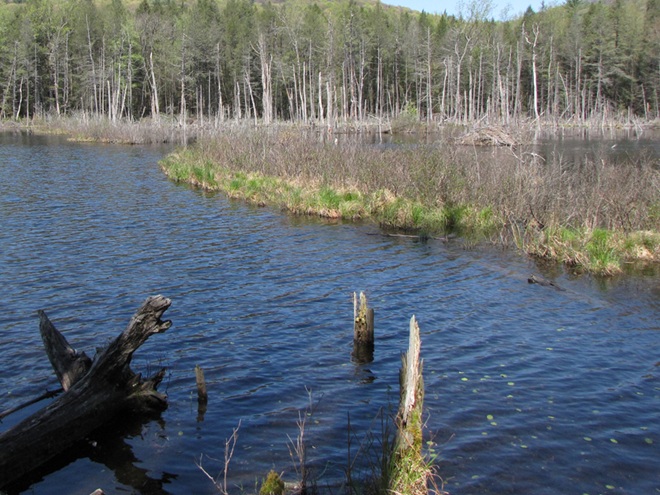


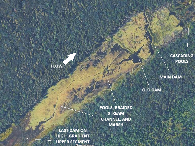
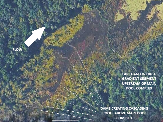


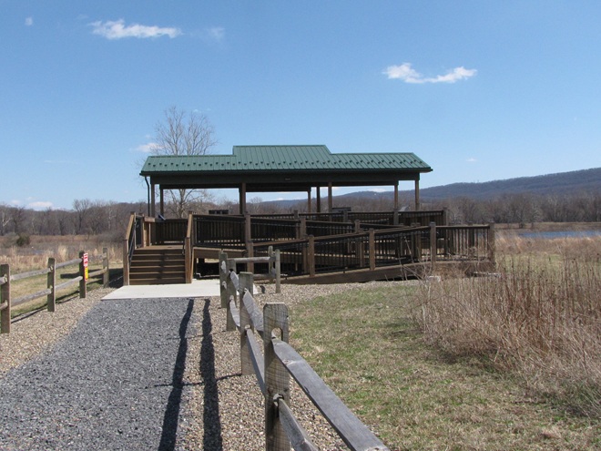


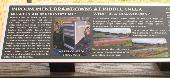


 Radiation")


 Watershed")