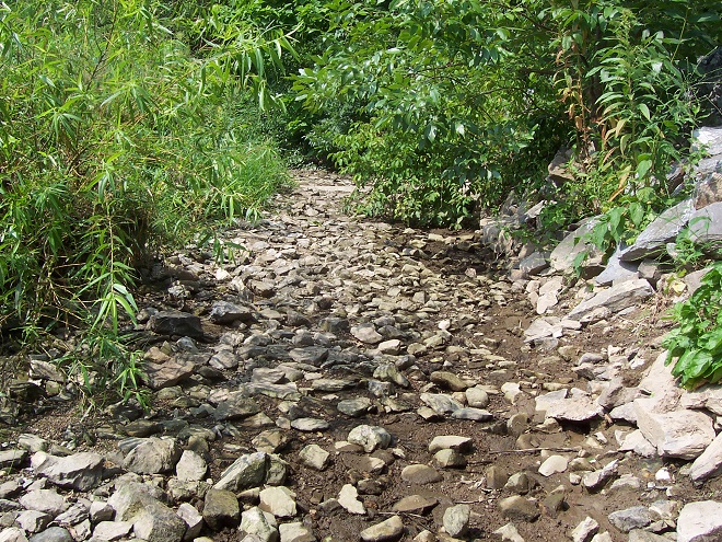
It all started rather innocently as a typically cold early January with sheets of ice covering the river and with soils on the lands in the remainder of the lower Susquehanna watershed frozen solid. Then came the “Blizzard of ’96”, blanketing much of the valley with between 20 and 30 inches of wind-driven snow.
Snowfall totals for the “Blizzard of ’96”, January 6-8, 1996. (NOAA/National Weather Service image)
In affected areas of Pennsylvania, Governor Tom Ridge closed all state roads for the duration of the snowfall event. Many would remain closed for much of the following week as drifting hampered exhaustive efforts to get impassable routes open.
In congested, high-density neighborhoods, cars remained buried for lack of anywhere to go with the snow. (Vintage 35 mm image)In more suburban areas, it was often a day-long chore to excavate a path to the street. (Vintage 35 mm image)
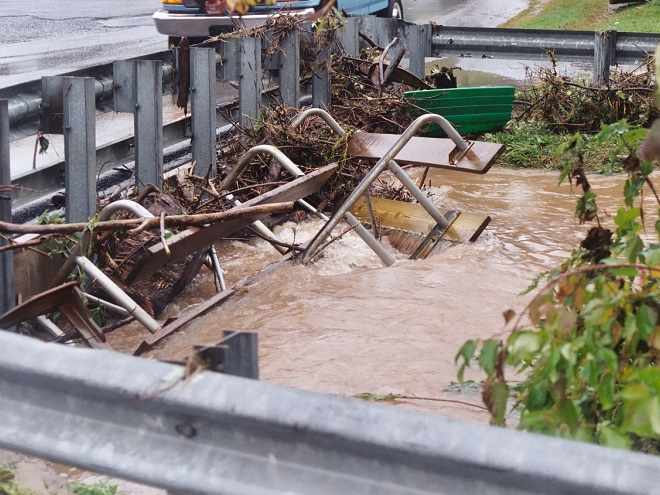
Just as the recovery entered its second week, a change in the weather pattern took hold as milder air and spring-like rains hastened the melt. Clogged by snow often several feet in depth, storm sewer inlets and other drainage features failed to collect the runoff. Street and urban flooding became widespread. Some buildings, particular those with large flat roofs, experienced structural damage due to any remaining snow soaking up the additional weight of the rain. As local creeks swelled to stain snowy meadows brown, attention shifted to the icy river.
On the Susquehanna, rising waters started moving ice into accumulating piles of car-sized chunks behind dams and at choke points along the river’s course. During warmer weather, stream gauges provide a depth of water reference known as a stage (measured in feet) that corresponds to a rate of flow passing the gauge site (measured in cubic feet per second). On occasions when ice and debris block river channels during winter, these readings can fluctuate wildly and the relationship between stage and flow can become dubious. When the water is running ice-free at Harrisburg for example, a gauge reading of about 11.1 feet is indicated when the river flow rate is approximately 162,000 cubic feet per second. But due to its impact on the capability of the river channels to pass water, the presence of slow-moving and jammed ice can cause rapid and sometimes unpredictable variations in gauge readings, even when the flow rate remains steady. Impaired by an ice jam at the gauging station or just downriver, a flow of 162,000 cubic feet per second could lead to a stage measurement significantly higher than 11.1 feet, and the area of adjacent floodplain inundated by rising waters will increase to a corresponding degree. Conversely, a jam upstream of the gauging station could cause the reading to drop below 11.1 feet—at least temporarily—then look out, a dangerous surge could be forthcoming!
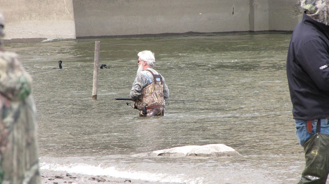
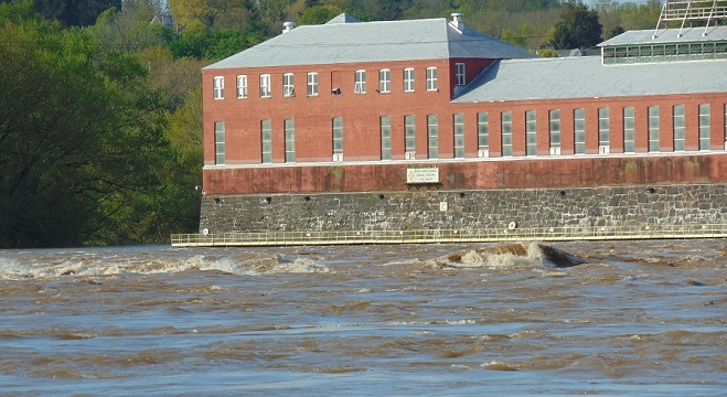
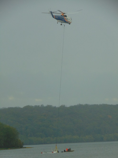
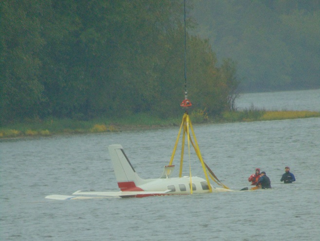
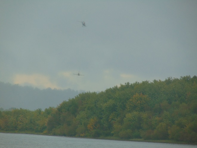
At Harrisburg, the ice jam behind the Dock Street Dam in January, 1996, caused devastating flooding in the city’s Shipoke neighborhood, on City Island, and in low-lying areas along the river’s west shore.
Just upriver from the Dock Street Dam at Harrisburg, the Susquehanna at the United States Geological Survey gauging station on the east side of City Island crested at 25.08 feet on January 20, 1996. As the rising waters finally began heaving the jammed ice up and over the dam, the scouring energy of the departing glacier-like mounds would carry away two spans of the truss-construction Walnut Street Bridge on the west side of the island, and eventually collapse a third. After receding during the remainder of the day and through the night, yet another aggregation of chunked ice would cause the river to crest again on January 21st, this time at 24.66 feet. Under free-flowing conditions, these readings would correspond to a river flow of just under 600,000 cubic feet per second; that’s more than 250 million gallons per minute!
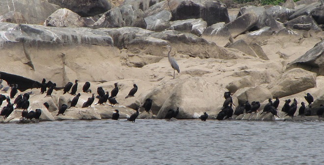
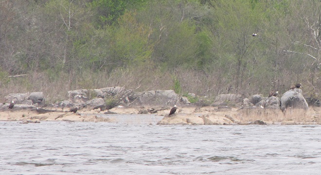
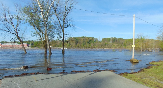
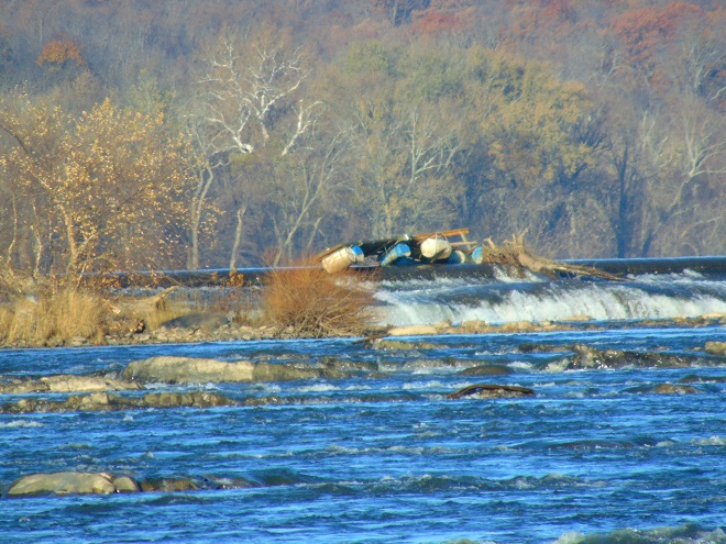
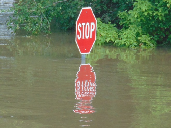
Downriver at Conewago Falls, ice jams behind the York Haven Dam and at several choke points within the riverine archipelago that extends from Haldeman Island to Haldeman Riffles in Lancaster County would be relieved as the river crested there during the afternoon of January 21st. The following photograph accurately relates the scene, minus the stench of mammalian feces and petroleum emanating from the polluted water of course.
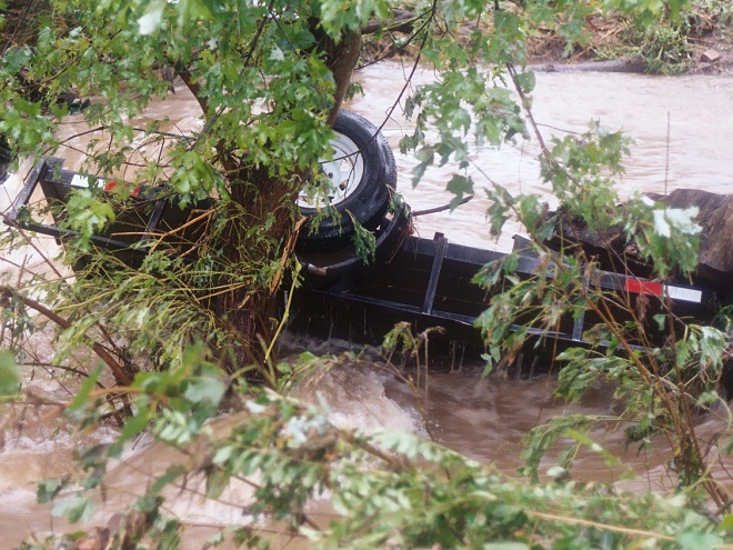
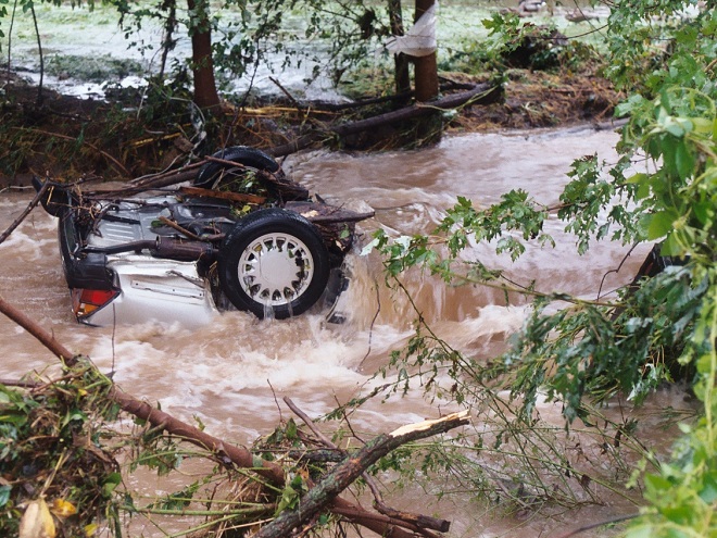
Our friends (L to R) Rick Morton, Bob Zeager, Dan Seitz and his daughter Sierra witness the ice-choked Susquehanna River cresting below Conewago Falls on January 21, 1996. Bob awoke the previous morning inside his mobile home (left rear) to discover he was rapidly being surrounded by fast-rising water. With the ice-covered road now submerged in over three feet of river, he had no hope of getting out with his van, so he started removing clothing and a few other essentials by canoe. Dan soon arrived to move a few of his things to higher ground and de-energize both properties. We did our best to lend a hand, then we all got out of the floodplain. A short time after we had departed, Rick arrived and became concerned when he saw Bob’s van, now in almost four feet of water alongside his home. Rick parked his conveyance, also a van, on a rise in the lowland terrain, then made his way back the old Pennsylvania Canal towpath to make sure Bob wasn’t stranded. After concluding that he had already evacuated, Rick returned via the towpath to his van. He then discovered that yet another surge of quickly rising water had inundated the ice-covered section of access road by which he had arrived, so he was forced to wade out, leaving his vehicle behind. A short time later, he reached us by telephone proclaiming, “I’m out!”, and filled us in on the details. As the flood receded, Rick was able to retrieve his van on January 22nd. Bob’s van was totally destroyed and both his and Dan’s mobile homes were left uninhabitable. Though by no means their first experience with river flooding, this event proved particularly costly and stressful for Bob and Dan…the effects life-altering. The moral of the story: floodplains are for flooding, not filling, not building, and certainly not dwelling. Floodplains happen to make outstanding wildlife preserves, and that’s what this water-purifying alluvial terrace wetland is today. (Vintage 35 mm image)
You may find this hard to believe, but during the colder months in the lower Susquehanna valley, gulls aren’t as numerous as they used to be. In the years since their heyday in the late twentieth century, many of these birds have chosen to congregate in other areas of the Mid-Atlantic region where the foods they crave are more readily available.
As you may have guessed, the population boom of the 1980s and 1990s was largely predicated on human activities. These four factors were particularly beneficial for wintering gulls…
Disposal of food-bearing waste in open landfills
High-intensity agriculture with disc plowing
Gizzard Shad population boom in nutrient-impaired river/Hydroelectric power generation
Fumbled Fast Food
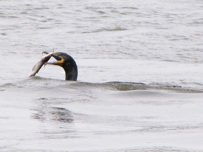
Earthworms lifted to the soil’s surface by plowing attracted Ring-billed Gulls by the thousands to Susquehanna Valley farmlands during the late twentieth century. (Vintage 35 mm image)Filter-feeding Gizzard Shad populations thrive in nutrient-rich waters like the Susquehanna. Their rambunctious feeding style stirs up benthic sediment deposits to release more nutrients into the water column and promote the algal blooms that often lead to detrimental eutrophic conditions. Decades ago, hundreds and sometimes thousands of gulls gathered below the river’s hydroelectric dams to feed on the seemingly endless supply of small Gizzard Shad disoriented by their passage through the turbines during electric generation. (Vintage 35 mm image)
So what happened? Why are wintering gulls going elsewhere and no longer concentrating on the Susquehanna? Well, let’s look at what has changed with our four man-made factors…
A larger percentage of the lower Susquehanna basin’s household and food industry waste is now incinerated/Landfills practice “cover as you go” waste burial.
Implementation of “no-till” farming has practically eliminated availability of earthworms and other sub-surface foods for gulls.
The population explosion of invasive Asiatic Clams has reduced the Gizzard Shad’s relative abundance and biomass among filter feeders.
Hold on tight! Fast food has become too expensive to waste.
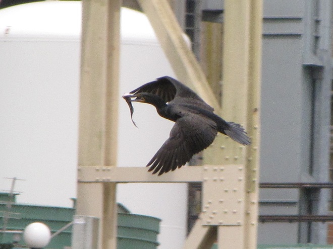
The non-native population of Asiatic Clams in the Susquehanna and most of its larger tributaries exploded during the last two decades of the twentieth century. Its present-day biomass in the river is exceeded by no other macroinvertebrate species. The share of plankton and other tiny foods that the Asiatic Clam harvests from the water column is no longer available to native filter-feeders including Gizzard Shad. Hence, Gizzard Shad biomass has been reduced and far fewer are available to attract amazingly enormous flocks of hungry gulls to hydroelectric dams. (Vintage 35 mm image)
GULLS THIS WINTER
Despite larid abundance on the lower Susquehanna not being the spectacle it was during the man-made boom days, an observer can still find a variety of medium and large-sized gulls wintering in the region. We ventured out to catch a glimpse of some of the species being seen both within the watershed and very nearby.
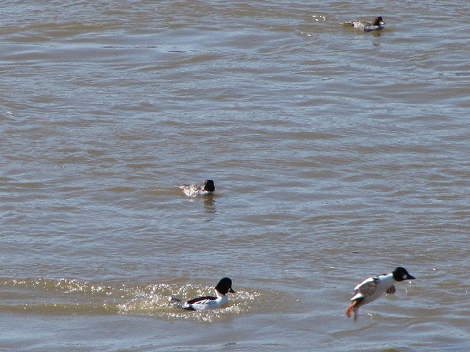
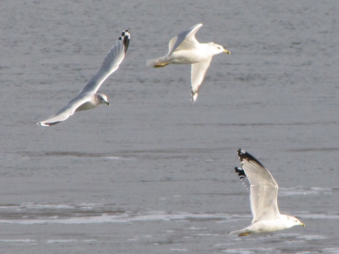
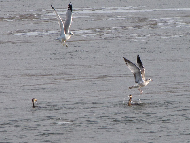
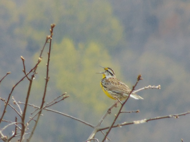
By far, most of the gulls you’ll encounter in the Lower Susquehanna River Watershed right now are Ring-billed Gulls. Some of them still drop by at the business end of the drive-thru lane looking for a lost order of fries and maybe a cheeseburger in paradise.First-winter (left), second-winter (center), and adult Ring-billed Gulls on the Susquehanna.Nearly every flock of gulls found in our area right now is composed exclusively of Ring-billed Gulls. The trick to finding other species, particularly rarities, is to look for slightly larger birds mixed among them, particularly American Herring Gulls like the first-winter (back row left) and third-winter (back row right) birds seen here. Herring and other species of similar-sized gulls seem to prefer each other’s company while on the wintering grounds.Five American Herring Gulls with smaller Ring-billed Gulls. The bird to the upper left and the bird hunkered down to its right are adult American Herring Gulls, the three brownish birds are in their first winter.Non-adult American Herring Gulls in flight. Always look for birds with all-pale wing tips when encountering herring gulls in flight.Midway in size between the Ring-billed Gulls in the foreground and the first-winter American Herring Gulls in the upper left and middle right of this image is a Lesser Black-backed Gull (dark-mantled bird resting at center). The similar-sized bird in the water behind it is a first-winter Iceland Gull (Larus glaucoides), a rare visitor from the arctic.Another look at the first-winter Iceland Gull from the previous image. Did you notice the all-white primary feathers and compare them to the dark wing tips on the Ring-billed Gulls seen here in its company?The conspicuously pale wings of the first-winter Iceland Gull, seen here bathing in the presence of two first-winter American Herring Gulls.Both this first-winter Iceland Gull and the bird from the previous three images are currently being seen just east of the Susquehanna watershed at Blue Marsh Lake in Berks County, Pennsylvania. Additional Iceland Gulls are currently being reported in Maryland on the Susquehanna at Conowingo Dam; on upper Chesapeake Bay in Baltimore County, Maryland; and in southeastern-most Bucks County, near Tullytown, Pennsylvania, at a busy landfill site that attracts tens of thousands of gulls each winter. Double-digit numbers of Iceland Gulls have been reported at this latter site during recent weeks.Lesser Black-backed Gulls like this one observed at Blue Marsh Lake are uncommon in the Lower Susquehanna River Watershed. They are progressively more likely as you travel east toward the aforementioned Bucks County landfills where hundreds of these birds make up a core Atlantic seaboard population.Great Black-backed Gulls are the most frequently encountered large gull on the Susquehanna. They’re easily identified by their enormous size and, as adults, their dark mantle.Rivaling the Great Black-backed Gull in size is the Glaucous Gull (Larus hyperboreus), another rare arctic visitor with pale wing tips. There are numerous reports of these unusual winter visitors from sites on Delaware Bay north to the Tullytown landfills on Delaware River where half a dozen or more have been occurring. Seen near the mouth of the Susquehanna on Chesapeake Bay at North East, Maryland, has been a first-winter bird similar to this one that we photographed at Blue Marsh Lake in Berks County, Pennsylvania.
For us, seeing a Glaucous Gull brought back memories of the last time we saw the species. It was forty-five years ago on New Year’s Day 1981 that we discovered two first-winter birds feeding on Gizzard Shad in open water on an otherwise ice-choked Susquehanna below the York Haven Dam powerhouse at Conewago Falls. Hey Doc Robert, do you remember that day?
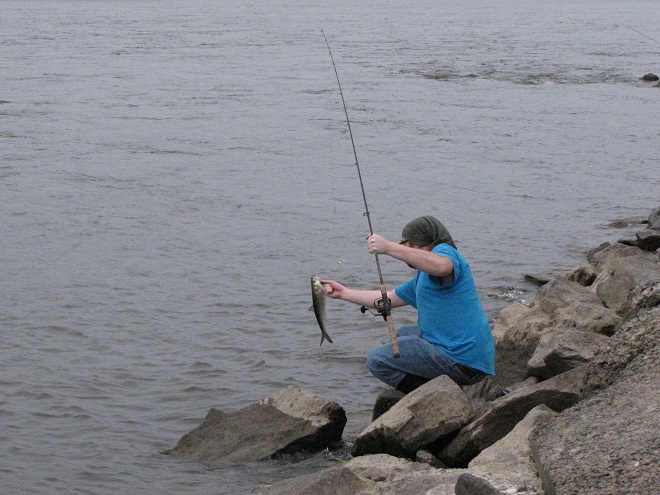
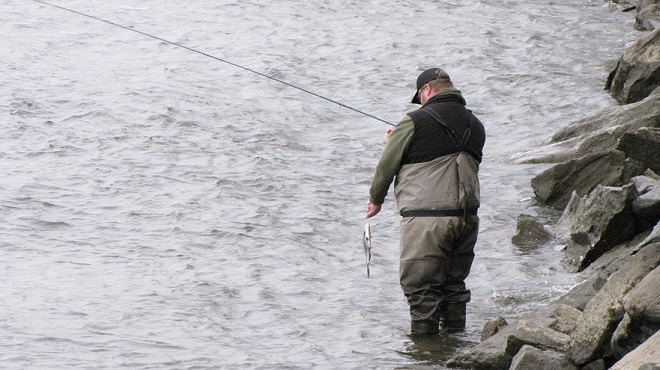
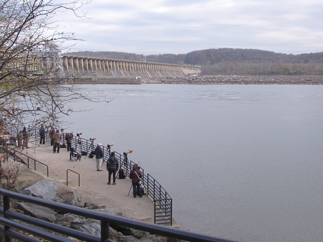
As the Flowering Dogwoods remind us, it’s time for adult sea-run shad and other fishes to ascend the Susquehanna to spawn. So yep, we’re off to Fisherman’s Park on the river’s west shoreline below Conowingo Dam in Harford County, Maryland, to check it out.
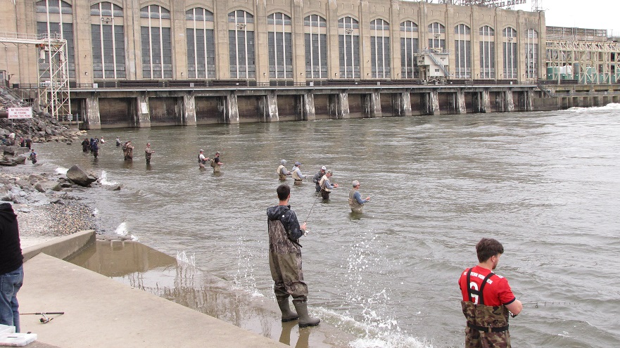
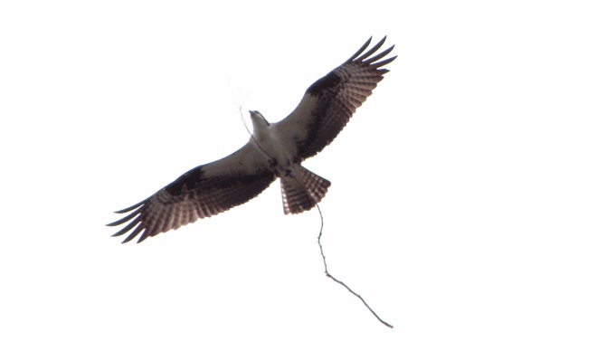
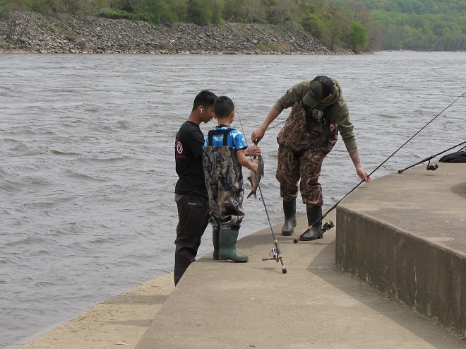
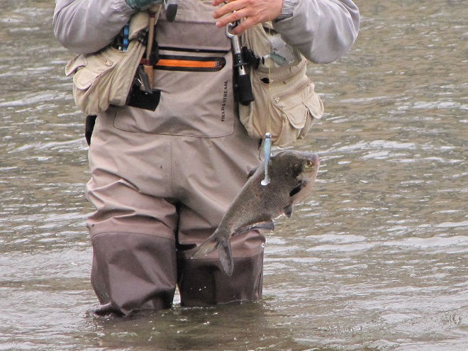
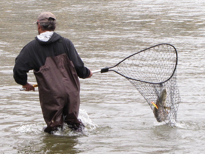
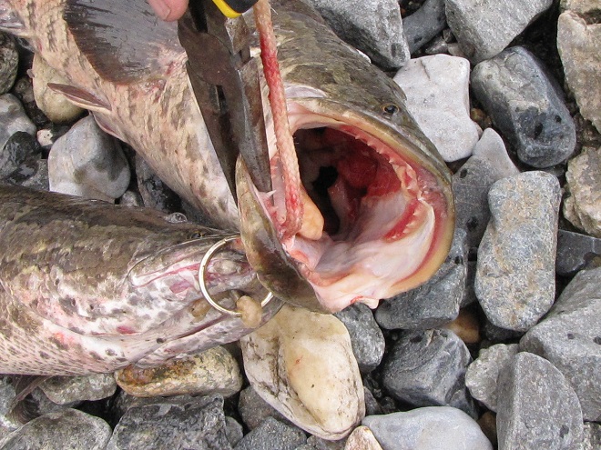
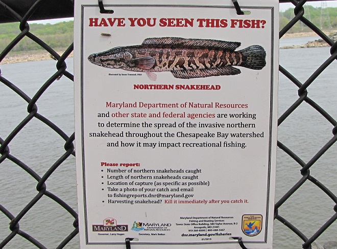
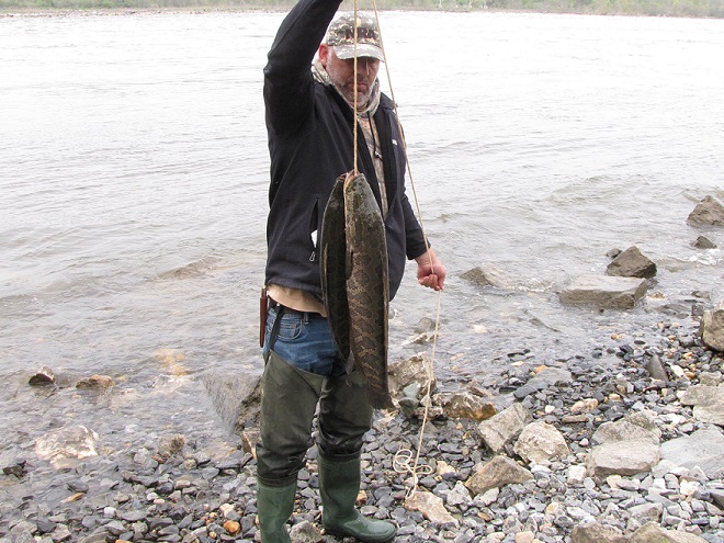
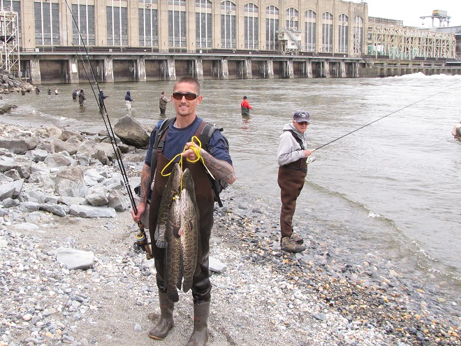
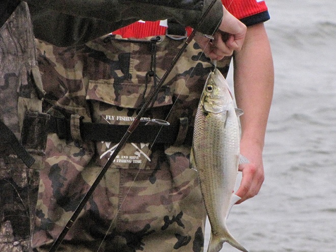
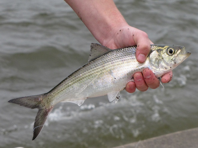
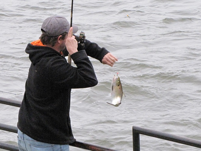
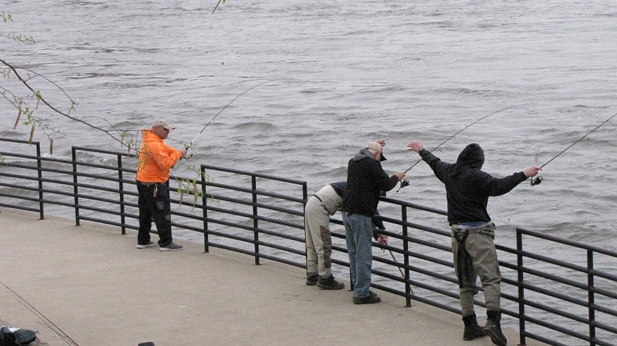
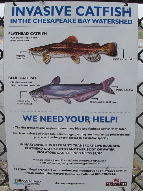
Anglers were in the water and seeing action as we arrived below Conowingo Dam’s powerhouse at Fisherman’s Park. The east lift, which was constructed during the 1990s to raise American Shad and other migratory fish over the dam during their spring spawning runs, sits idle at the impoundment end of the wing wall in the distance.The entrance to the idle east fish lift at Conowingo Dam.Within minutes, we watched one of the culprits responsible for the lift’s shutdown being reeled in. The invasive population of introduced Northern Snakeheads continues to thrive in the waters of the Susquehanna and its tributaries below the dam. To prevent it from expanding its range to upriver sections of the watershed, all American Shad are being manually separated from among the snakeheads and other fish species deposited into sorting tanks using the west lift near the powerhouse.One of several specialized transport vehicles returns from a “shad run” to the waters of the Susquehanna above York Haven Dam at Conewago Falls after delivering and releasing American Shad sorted from among the fish collected at Conowingo’s west lift earlier in the day.American Shad began their run up the Susquehanna as water temperatures reached 60 degrees Fahrenheit…just about the time the Flowering Dogwoods started to bloom within the river’s riparian woodlands. Later this month, spawning activity peaks when the water warms to about 65 degrees. Earlier in the season, when the water reached about 55 degrees, another anadromous species, the Hickory Shad (seen here), began their spring spawning run from sea to freshwater rivers and streams.While American Shad are seldom caught on hook and line, Hickory Shad are a popular catch-and-release target. Though they will energetically strike baits like the small shad dart seen here, Hickory Shad are very cautious while ascending the river; they very rarely enter the fish lifts to join the dozens of other species that readily accept their use. With water temperatures now in the sixties, an angler is seen here bringing in what may be among the last of this season’s Hickory Shad. Their spawning run is presently drawing to a close for the year.The most commonly caught herring at Fisherman’s Park is the Gizzard Shad. This plankton feeder seldom takes bait; it is instead foul-hooked. Though not a sea-run species, Gizzard Shad by the tens of thousands leave open waters to seek shallower flowing riffles and pools to spawn.Unlike the other herring occurring in the Susquehanna, the Gizzard Shad has a blunt, snub-nosed appearance to the snout. The mouth is small and often unnoticeable.The Gizzard Shad is the only species of Susquehanna herring that can legally be harvested. All others are sea-run migrants in varying degrees of population peril and must be returned to the water without delay.Note the elongated last ray on the dorsal fin of this foul-hooked Gizzard Shad. It’s a not-often-visible but nevertheless tell-tale field mark.Humans aren’t the only creatures attracted by the fish migration on the lower Susquehanna. This is just one of hundreds of Double-crested Cormorants we watched during our visit.Hungry cormorants gather along the base of the dam where ascending fish congregate and become further disoriented by water turbulence.Fishing efforts here can bring great success to these accomplished piscivores.Latching onto an oversize Gizzard Shad can make you very popular with your peers.So popular that you may never have the opportunity to eat your lunch.Take it from this old bird: you’ve gotta swallow ’em fast, head first, tail and all.A Bald Eagle hauls off a Gizzard Shad.An Osprey saw this Gizzard Shad swimming close enough to the water’s surface to dive in and snag it with its talons.And yet another successful Bald Eagle calls out to its mate as it approaches its nest and hungry young.An angler releases a small Striped Bass caught on a shad dart while fishing for Hickory Shad. To reduce pressure on their populations during the spring spawning run, the “Striper” harvest is presently closed. The fishing season resumes later this month in some areas, in June within others. On the Susquehanna Flats and other Chesapeake Bay waters, Striped Bass are also known as “Rockfish”.This angler is reeling in a big one.A nice Channel Catfish weighed in at about six pounds and was released.This angler brought in yet another interesting catch.The White Perch (Morone americana) is a bay species that ascends the Chesapeake’s tributaries to spawn during the spring. On the lower Susquehanna, numbers of this relative of the Striped Bass are falling, very possibly due to depredation by invasive snakeheads, Blue Catfish, and Flathead Catfish.A Double-crested Cormorant does its duty and snatches up an invasive Blue Catfish. Very large Blue Catfish exceeding 24 inches in length are becoming increasingly plentiful on the upper Chesapeake and its tributaries resulting in a significant negative impact on the aquatic ecosystems there. Like the Northern Snakehead and Flathead Catfish, these invasive species are very palatable and anglers are encouraged to catch and keep as many as they like.Maryland DNR sign at Fisherman’s Park.What can we do about the plague of Northern Snakeheads (Channa argus) in the Susquehanna? Well, let’s start by answering a question with a question…Why deplete ocean stocks when you can follow this angler’s example and harvest excellent fillets while helping to control an invasive species at the same time? And no, you don’t have to call them “Chesapeake Channa” if you don’t want to. Though you will make us laugh if you start calling them “Susquehanna Channa” or just “Susquechanna” from time to time.
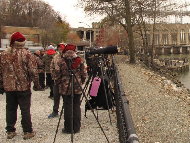
Few places in North America offer an observer the opportunity to stand in one spot and, with a single 180° sweep of a pair of binoculars, count 165 Bald Eagles. Sounds impossible, but we experienced just that earlier today along the Susquehanna River below Conowingo Dam at Fisherman’s Park off U.S. Route 1 west of Rising Sun, Maryland. More than 200 eagles are there right now, so you really ought to think about visiting to see it for yourself. If you can’t make the trip, or if you need a little more convincing, we’ve put together a big collection of photographs for you to enjoy. Have a look…
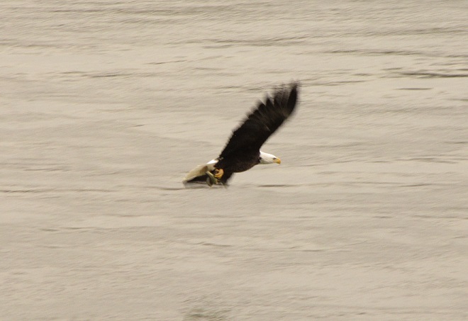
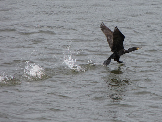
In late November and December, hundreds of eagle watchers and photographers travel to Fisherman’s Park along the west shore of the Susquehanna River below Conowingo Dam/U.S. Route 1 to witness the largest annual gathering of our national symbol on the east coast.The park provides facilities for viewing right on the waterfront and is maintained by the operator of the hydroelectric dam, Constellation Energy.From the riverside viewing area, we counted 165 Bald Eagles on the rocks along the east shore of the river and on the electric transmission line trestles. That count didn’t include scores of additional birds obstructed from our view along the near shore downstream and along the east shore behind the mid-river island below the dam.A closeup of some of the 165 Bald Eagles we counted. Many of these birds, particularly the adults, are eagles that nest to our north and are here for a short winter stay. Local breeding pairs, including several with nests along the river below the dam, are already courting, copulating, and defending territories; the latter no easy task for the Conowingo birds facing all these visitors.The concentrations of Bald Eagles at Conowingo Dam sometimes provide an excellent opportunity to study the plumage of birds from the various age classes. Today’s assemblage put on a clinic.A nice, neat hatch-year/juvenile Bald Eagle in its first full set of feathers shows no molt.This bird was an unusual find, a hatch-year/juvenile Bald Eagle with early signs of molt. There’s even a new secondary feather visible in the gap on the left wing.The wings of a second-year/basic I immature Bald Eagle have a ragged appearance created by the long juvenile secondary feathers that have yet to be dropped.Another second-year/basic I immature Bald Eagle showing some longer juvenile secondaries on each wing.A third-year/basic II immature Bald Eagle showing a neater, cleaner trailing edge of the wings with no more long juvenile flight feathers. The wide dark stripe through the face gives the bird an osprey-like appearance. The bill color is usually more noticeably yellow than a second-year bird, but both can have extensive white in the belly feathers and elsewhere on the underside and shoulders.Third-year/basic II immature Bald Eagles exhibiting aggressive behavior.A fourth-year/basic III immature Bald Eagle with a black-bordered tail, yellow bill, and a thin dark line through the eye. Birds this age are mostly dark below, but often retain some white feathers which present a spotted appearance.The water passing through the dam not only attracts eagles, but other birds as well. Many, including these gulls, are looking for fish stunned or disoriented by their trip through the turbines, gates, or spillways.More than one hundred Ring-billed Gulls are currently being seen at Conowingo Dam.We saw a few American Herring Gulls as well.A juvenile American Herring Gull.Probably a hundred Black Vultures or more were in the vicinity.A Black Vulture by the park’s riverside lookout.We heard this Peregrine Falcon as it tangled with several eagles behind us before it quickly darted away across the top of the powerhouse and dam.Double-crested Cormorants were diving persistently in search of unwary prey.A composite image of a Double-crested Cormorant gulping down a Gizzard Shad.But these vigilant eagle watchers and photographers don’t come to Conowingo Dam and Fisherman’s Park to see Bald Eagles of various age classes flying around. Nor do they come to see the other amazing birds attracted to the waters passing through the dam.And they don’t even come to see some pretty good aerial fights among the numerous eagles congregated in the river gorge.They come specifically to see and photograph Bald Eagles swooping in to grab a fish. That’s their objective and they’re serious about it!A probable fourth-year/basic III immature Bald Eagle with a Gizzard Shad.An immature Bald Eagle swoops in to grab a fish.An immature Bald Eagle stretches its wings forward with a deep stroke to lift a fish from the Susquehanna.A Bald Eagle, possibly a fifth-year/basic IV bird, carrying away a freshly caught Gizzard Shad.An adult Bald Eagle comes in for the grab.An adult Bald Eagle comes away with a Gizzard Shad.Now the hard part, finding a place to eat its catch in peace.
If you go to Fisherman’s Park, time your visit for when the light is at its best—late morning through early afternoon. Don’t forget, it’s very cold down along the river, so dress appropriately. And finally, visit on a weekday if you can. The parking area can fill to capacity during the weekend and you may be turned away.
Don’t wait. The eagles visiting the Susquehanna at Conowingo Dam could get pushed further south by rough winter weather. Then again, adult pairs may take advantage of milder conditions to begin returning north early to nest.
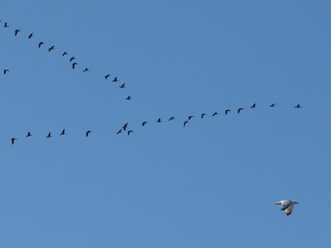
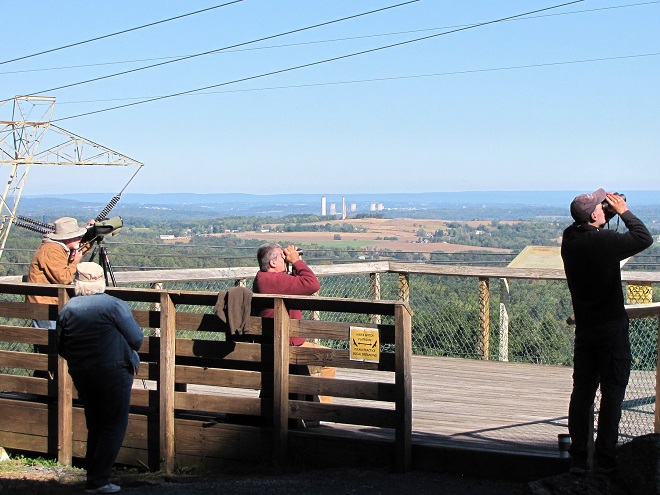
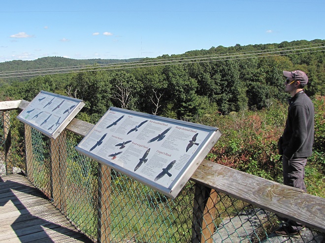
As we enter November, migratory raptor flights through the Lower Susquehanna River Watershed transition to the bigger birds. Whether you’re on the river, on a mountain, or just outside your humble abode, persistent alertness to soaring avians can yield rewarding views of a number of late-season specialties.
Red-tailed Hawks dominate the southbound raptor flights in November.Juvenile (hatch-year) Red-tailed Hawks are generally less wary and more inquisitive than the more experienced adult birds. Their curiosity frequently gets them into trouble, particularly when they try to hunt small rodents in traffic along busy roadways.Far fewer in number are migratory Red-shouldered Hawks. In our region, these denizens of bottomland forests more commonly migrate along the southern edge of the Piedmont and through the upper Atlantic Coastal Plain.A southbound hatch-year (juvenile) Red-shouldered Hawk.Mixed-race Peregrine Falcons, the descendants of birds reintroduced into the Mid-Atlantic States during the late twentieth century, often roam our region during the late-fall and winter months before settling into their nesting territories with the approach of spring. We spotted this one along a local ridge, but you may be more likely to see them in the city or near a bridge or dam on the river.As this adult peregrine passed the lookout, we noted its full crop. A sign it just completed a successful hunt.
A visit to a ridgetop on a breezy day—particularly after passage of a cold front—may give you the chance to see numerous eagles as well.
A second-year (Basic I) Bald Eagle barrel rolls while pursuing an adult Bald Eagle.
This afternoon, we got lucky and were treated to a bit of an aging clinic presented by the Bald Eagles we observed and photographed. Careful determination of the age classes of raptors counted by hawkwatchers can provide an early warning of problems in the ecosystems that support populations of these top-of-the-food-chain predators. For example: during the 1950s and early 1960s, a progressively lower percentage of juvenile and other non-adult age classes among the Bald Eagles being observed forewarned of the dangers of dichlorodiphenyltrichloroethane (DDT) pesticide in the environment. The principle effect of accumulations of the DDT toxins in eagles, Ospreys, Peregrine Falcons, and other predatory birds that consumed waterfowl and/or fish was to thin their eggs shells. The result was widespread brood failure and a near total loss of new generations of offspring. Eventually, nearly all Bald Eagles being seen in areas impacted by DDT were progressively older adults, most of which failed as nesting pairs. As the adult birds began dying off, the Bald Eagle population dwindled to numbers that raised fears of the species’ extinction. Implementation of the DDT cancellation order and the Clean Water Act in 1972, and the Endangered Species Act in 1973, helped save the Bald Eagle. But our regional “Eastern Peregrine Falcon”, a bird with a shorter life span than the Bald Eagle, was unable to endure the years of DDT use, dioxin pollution, and illegal hunting and egg collecting. Its population is gone.
A hatch-year (juvenile) Bald Eagle is typically dark headed and in a fresh set of juvenile flight feathers that exhibit no signs of molt. If the reproduction season and the months that followed were favorable for this year’s brood of new eagles, there should be nearly as many hatch-year birds as there are adults in an overall population.By November, second-year (Basic I) Bald Eagles are replacing many of their flight feathers and often show ragged trailing edges in the wings due to the retention of some of the well-worn and notably longer juvenile feathers. Varying amounts of white mottling are visible on the breast, belly, and underwing coverts. Due to mortality, there are usually fewer second-year Bald Eagles than there are hatch-year or adult birds.Another example of a second-year (Basic I) Bald Eagle.Third-year (Basic II) Bald Eagles show more yellow in the bill and an “osprey face”, a white head with a wide dark line through the eye. Most of the juvenile flight feathers have been replaced, so the wing edges appear more uniform. Like the second-year eagles, there is a varying amount of white in the breast, belly, and underwing coverts. In an overall population of eagles, birds in this age class are usually less common than those that are younger or those that are adults.Composite image of Bald Eagles in typical November plumage during their first three years. To see more images like this, be certain to click the “Hawkwatcher’s Helper: Identifying Bald Eagles and other Diurnal Raptors” tab at the top of this page.A fourth year (Basic III) Bald Eagle will often be seen with a black-bordered tail and a thin dark line through the eye. In some birds, traces of these traits can linger into the fifth year and beyond. These plumage types are usually the least frequently observed among an overall population of Bald Eagles. (Note: In these older birds, there develops significant variation in the timing of feather molt. In rare cases, fourth-year Bald Eagles may show minimal dark color in the tail or eye line and may appear to be in near definitive adult plumage.)A possible fifth-year (Basic IV) Bald Eagle.Adult Bald Eagles in definitive plumage. Birds in this plumage class are often the most frequently observed because the group includes all eagles five or six years of age and older.
While the Bald Eagles are still stealing the show, cold and gusty weather should bring an increasing number of Golden Eagles our way during the remainder of the month. Some are already trickling through…
This “before-third-year” Golden Eagle shows no visible signs of molt in its juvenile (hatch-year) plumage, but a look at the upperwing coverts is needed to properly age the bird. To learn more about the molt sequence in Golden Eagles, be sure to click the “Golden Eagle Aging Chart” tab at the top of this page.A “before-third-year” Golden Eagle (top) passing the lookout along with a second-year Bald Eagle (bottom).Another “before-third-year” Golden Eagle. More are on the way!
Later this month, Bald Eagle numbers on the lower Susquehanna below Conowingo Dam (U.S. 1) near Rising Sun, Maryland, will begin to grow. Fisherman’s Park, located along the west shoreline below the dam, is an excellent place to observe and photograph scores of these regal birds. And few places provide a better opportunity to learn to differentiate Bald Eagle age classes. If you’re really lucky, a Golden Eagle or two may drop in as well. So plan to make the trip. The best time to visit is on a weekday. The parking lot can become overcrowded on weekends and will be closed under such circumstances. It’s best to avoid the long Thanksgiving weekend as well.
The deluge of rain that soaked the lower Susquehanna watershed during last week is now just a memory. Streams to the west of the river, where the flooding courtesy of the remnants of Hurricane Debby was most severe, have reached their crest and receded. Sliding away toward the Chesapeake and Atlantic is all that runoff, laden with a brew of pollutants including but not limited to: agricultural nutrients, sediment, petroleum products, sewage, lawn chemicals, tires, dog poop, and all that litter—paper, plastics, glass, Styrofoam, and more. For aquatic organisms including our freshwater fish, these floods, particularly when they occur in summer, can compound the effects of the numerous stressors that already limit their ability to live, thrive, and reproduce.
(Environmental Protection Agency image)
One of those preexisting stressors, high water temperature, can be either intensified or relieved by summertime precipitation. Runoff from forested or other densely vegetated ground normally has little impact on stream temperature. But segments of waterways receiving significant volumes of runoff from areas of sun-exposed impervious ground will usually see increases during at least the early stages of a rain event. Fortunately, projects implemented to address the negative impacts of stormwater flow and stream impairment can often have the additional benefit of helping to attenuate sudden rises in stream temperature.
While a row of trees along a creek can help provide protection from the thermal impact of the sun, a vegetative riparian buffer must be much wider to be effective for absorbing, cooling, and treating runoff from fields, lawns, and paved surfaces. This buffer is too narrow to prevent surface runoff from polluting the water.
Of the fishes inhabiting the Lower Susquehanna River Watershed’s temperate streams, the least tolerant of summer warming are the trouts and sculpins—species often described as “coldwater fishes”. Coldwater fishes require water temperatures below 70° Fahrenheit to thrive and reproduce. The optimal temperature range is 50° to 65° F. In the lower Susquehanna valley, few streams are able to sustain trouts and sculpins through the summer months—largely due to the effects of warm stormwater runoff and other forms of impairment.
Sculpins, including the Blue Ridge Sculpin (Cottus caeruleomentum) seen here, are native coldwater fishes which, during the 11,000 years since the last glacial maximum, have had the availability of their favored habitat sharply reduced by warming water temperatures and a rising Atlantic. During this interval, seawater has inundated the path of the “Late” Pleistocene lower Susquehanna which passed through the section of flooded river watershed we now call Chesapeake Bay and continued across the continental shelf to what was, during the glacial maximum, the river’s mouth at Norfolk Canyon. Today, cut off from neighboring drainage basins, sculpins survive exclusively in cold headwaters, and only in those where human alterations including pollution, dams, channelization, and reduced base flow haven’t yet eliminated their isolated populations. Formerly believed to be composed of two widespread North American species, the Slimy Sculpin (Cottus cognatus) and the Mottled Sculpin (Cottus bairdii), study in recent decades is discovering that sculpin populations in the present-day lower Susquehanna and neighboring Potomac headwaters consist of at least three newly delineated species: Blue Ridge Sculpin, Potomac Sculpin (Cottus gerardi), and Checkered Sculpin (Cottus sp.), the latter an as yet undescribed species found only in the refugium of limestone springs in the Potomac drainage in West Virginia; Frederick and Washington Counties, Maryland; and Franklin County, Pennsylvania. (United States Geological Survey image)Stare at this for a little while, you’ll figure it out…………More than 11,000 years ago, during the end of the last glacial period, when sea level was about 275 feet lower than it is today, there was no Chesapeake Bay, just a great Susquehanna River that flowed to the edge of the continental shelf and its mouth at Norfolk Canyon. It was a river draining taiga forests of pine, spruce , and fir, and it carried along the waters of all the present-day bay’s tributaries and more. The section of the river’s watershed we presently call the lower Susquehanna was, at the time, the upper Susquehanna watershed. Brook Trout and sculpins had the run of the river and its tributaries back then. And the entire watershed was a coldwater fishery, with limestone and other groundwater springs providing not refuge from summer heat, but a place to escape freezing water. (United States Geological Survey base image)Norfolk Canyon, the mouth of the Susquehanna River during the most recent glacial maximum, now lies more than 275 feet below the surface of the ocean and plunges to more than a mile in depth along the finger of out wash from the gorge. (United States Geological Survey image)Tens of thousands of trout are raised in state-operated and cooperative nurseries for stocking throughout the lower Susquehanna valley. These rearing facilities are located on spring-fed headwaters with sufficient flow to assure cold temperatures year round. While the Rainbow Trout and Brown Trout (Salmo trutta) are the most commonly stocked species, the Brook Trout (Salvelinus fontinalis) is the only one native to American waters. It is the least tolerant of stream warming and still reproduces in the wild only in a few pristine headwaters streams in the region. During spring, all three of these species have been observed on rare occasions entering the fish lift facilities at the hydroelectric dams on the river, presumably returning to the Susquehanna as sea-run trout.
Coldwater fishes are generally found in small spring-fed creeks and headwaters runs. Where stream gradient, substrate, dissolved oxygen, and other parameters are favorable, some species may be tolerant of water warmer than the optimal values. In other words, these temperature classifications are not set in stone and nobody ever explained ichthyology to a fish, so there are exceptions. The Brown Trout for example is sometimes listed as a “coldwater transition fish”, able to survive and reproduce in waters where stream quality is exceptionally good but the temperature may periodically reach the mid-seventies.
The Eastern Blacknose Dace is sometimes classified as a “coldwater transition fish”. It can be found in headwaters runs as well as in creeks with good water quality.The Longnose Dace is another “coldwater transition fish” known only from clear, clean, flowing waters.
More tolerant of summer heat than the trouts, sculpins, and daces are the “coolwater fishes”—species able to feed, grow, and reproduce in streams with a temperature of less than 80° F, but higher than 60° F. Coolwater fishes thrive in creeks and rivers that hover in the 65° to 70° F range during summer.
The Creek Chub is a familiar species of “coolwater fish” seldom found remaining in waters exceeding 80 degrees Fahrenheit.The Yellow Perch (Perca flavescens) was perhaps the most frequently targeted coolwater “gamefish” in the Lower Susquehanna River Watershed prior to the introduction of the Northern Pike (Esox lucius) and Muskellunge (Esox masquinongy). Today’s prevalence of warmwater streams and the dozens of species of non-native predatory fishes now naturalized within them have left the Yellow Perch populations greatly reduced and all but forgotten by anglers. Out of sight, out of mind. (National Park Service image)
What are the causes of modern-day reductions in coldwater and coolwater fish habitats in the lower Susquehanna River and its hundreds of miles of tributaries? To answer that, let’s take a look at the atmospheric, cosmic, and hydrologic processes that impact water temperature. Technically, these processes could be measured as heat flux—the rate of heat energy transfer per unit area per unit time, frequently expressed as watts per meter squared (W/m²). Without getting too technical, we’ll just take a look at the practical impact these processes have on stream temperatures.
HEAT FLUX PROCESSES IN A SEGMENT OF STREAM
Heat Flux Processes on Stream and River Segments. These processes could be measured as heat flux—the rate of heat energy transfer per unit area per unit time. (Environmental Protection Agency image)
INCOMING TEMPERATURE AND FLOW—The baseline temperature of stream water entering a given segment of waterway is obviously the chief factor determining its temperature when exiting that segment. Incoming temperature and flow also determine the water’s susceptibility to heat absorption or loss while transiting the segment. Lower flows may subject the given volume of water to a greater loss or gain of heat energy during the time needed to pass through the segment than the same volume at a higher flow. Lower flows may also reduce stream velocity and extend a given volume of water’s exposure time to the exchange of heat energy while moving through the segment. Generally speaking…
…the higher the stream flow, the less a given volume of that stream’s water may be impacted by the effects of the heat flux processes within the segment.
…the lower the stream flow, the more a given volume of that stream’s water may be impacted by the effects of the heat flux processes within that segment.
…the temperature and flow rate of precipitation entering the segment are factors that determine the impact of its heat energy transfer to or from a given volume of the stream’s waters.
…the temperature and flow rate of runoff and point-source discharges entering the segment are factors that determine the impact of their heat energy transfer to or from a given volume of the stream’s waters.
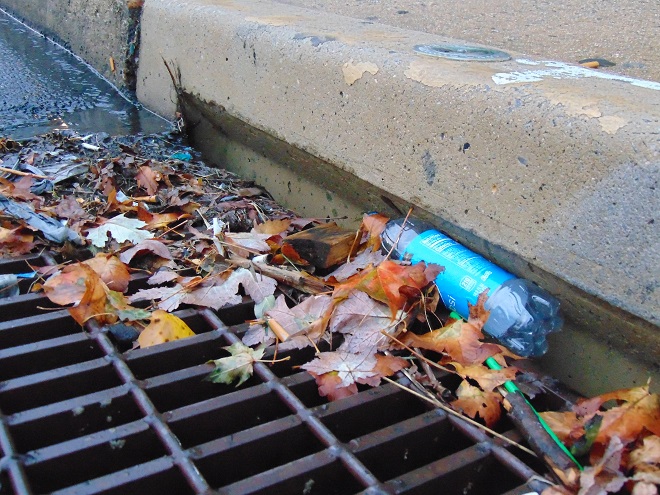
Stormwater from impervious surfaces including roads, parking lots, roofs, and lawns quickly impacts temperatures in small creeks. Channelized streams are availed few of the positive attributes provided by many of the heat flux processes we’re about to see. They therefore suffer from severe impairment and are exposed to temperature extremes that few aquatic organisms can survive. Runoff from sun-heated pavement during a summer thunderstorm can often exceed 100 degrees Fahrenheit and can, at sufficient flow rate, quickly raise the temperature of a small stream to well over 90 degrees.Stormwater runoff not only poses a thermal threat to waterways, its a significant source of a wide variety of pollutants.
GROUNDWATER INPUT—In streams connected to the aquifer, the temperature in a flowing segment can be impacted by the influx of cold groundwater. With temperatures ranging from about 52° to 60° Fahrenheit, groundwater will absorb heat from the stream in summer, and warm it in the winter. In warmwater streams, coldwater and coolwater fishes will often seek areas of the substrate where groundwater is entering for use as refugium from the summer heat. Yellow Perch in the lower Susquehanna are known to exhibit this behavior.
Creeks and rivers connected to the aquifer and receiving supplemental flow from it are known as “gaining streams”. These streams frequently feed water into the aquifer as well. (United States Geological Survey image)When flowing through an area experiencing drought or an excessive removal of groundwater (lots of wells, etc.), a waterway can become a “losing stream”, one that surrenders a portion of its flow to recharge the aquifer. Further downstream, the reduced flow can make such a creek or river more susceptible to the effects of heat flux processes. (United States Geological Survey image)Seriously depleted aquifers can lead to a “disconnected stream”. Smaller waterways subjected to these conditions will sometimes lose all their flow to the ground, often causing a catastrophic failure of the aquatic ecosystem supported therein. (United States Geological Survey image)Urban runoff overwhelms this small stream with polluted water than can reach temperatures of 100 degrees or more (left), then lets it high and dry with no baseflow during periods of dry weather (right) as the waterway becomes disconnected from the much-depleted aquifer.Well-designed and properly constructed stormwater retention basins not only recharge groundwater supplies for wells and streams, they can also help prevent thermal pollution in waterways. Planted with native wetland species and allowed to thrive, they can become treasured wildlife islands in otherwise inhospitable environs. The benefits don’t stop there; plants also help sequester nutrients contained in the runoff.
HYPORHEIC EXCHANGE—Related to groundwater input, hyporheic exchange is the slow movement of water through the rock, sand, gravel, and soils composing the streambed, saturated shoreline, shallow aquifer, and connected floodplain of a creek or river. As a heat flux process, hyporheic exchange helps moderate extremes in seasonal water temperatures by conducting energy between the solid materials in the zone and the flowing water. Hyporheic zones are important habitats for many species of aquatic invertebrates and spawning fish. Natural chemical processes within these zones convert ammonia-producing wastes into nitrite, then nitrate, allowing it to be absorbed as food by plants growing in the stream or in the alluvium within the zone. Vegetation removal, channelization, legacy sediments, silt deposits, and man-made walls and dams can negate the benefits of hyporheic exchange.
Exchange of surface and ground water within the hyporheic zone is most directly associated with high-gradient (left) and meandering (right) segments of streams. (United States Geological Survey image)Very common on streams in the lower Susquehanna valley are these accumulations of legacy sediments at the sites of former mill ponds. After the dams were removed, the creeks began eroding their way down through the mire as they tried to reestablish their floodplains and find their native substrate. These trapped waterways are not only cut off from their hyporheic zones, they’re now a major source of nutrient and sediment pollution. Misguided landowners like this one frequently dump fill into these sites to “save their land” and “control flooding”. The fill and materials added to “shore up the banks” do nothing to fix what ails the creek, but instead displace more water to make the impact of flooding even more widespread.Rehabilitation projects that remove legacy sediments help restore hyporheic exchange by reconnecting the stream to its underlying geology, its floodplain, and its wetlands. Rising waters remain in the floodplain where they get a good bio-scrubbing and help replenish the creek and groundwater supply. As the experts say, “floodplains are for flooding.”
ATMOSPHERIC EXCHANGE (CONVECTION, EVAPORATION)—Primarily a process by which a stream loses heat energy and cools its waters, atmospheric exchange is also a means by which a warm air mass can relinquish heat to cooler waters and thus increase their temperature. This phenomenon can be dramatically enhanced when a stream passes through a so-called urban heat island where air temperatures remain warm through the night. Convection, the movement of heat energy through a fluid (liquid or gas), causes warmer, less-dense water to rise to the surface of a stream, particularly where there is minimal turbulence. When the air above is cooler than the water’s surface layer, the stream will conduct heat energy across the water/atmosphere interface causing the warmed air molecules to rise in a convection column. If the atmospheric relative humidity is less than 100%, some surface water will vaporize—a process that expends more of the stream’s heat energy. The rate of convective and evaporative cooling in a given stream segment is directly related to the degree of difference between the water temperature and air temperature, and to the relative humidity in the air mass above the lake, creek, or river. The mechanical action of stream turbulence including rapids, riffles, and falls increases the contact area between air and water to maximize the atmospheric exchange of heat energy. The convective air current we call surface wind has a turbulent wave-producing effect on water that can also maximize atmospheric exchange; think of a cold autumn wind robbing heat energy from a warm lake or river or a hot summer wind imparting its heat to a cooler creek. These exchanges are both conductive in nature (air-to-water/water-to-air) and evaporative, the latter being expedited by the movement of dry air over warm water.
Usually classified as one of the coolwater fishes, the bottom-dwelling Tessellated Darter can thrive in the warmer creeks and in the main stem of the Susquehanna by inhabiting riffles where atmospheric exchange in the form of increased evaporation helps reduce temperatures and convective currents carry the cooler, well-oxygenated water to the streambed.Humans utilize the concept of atmospheric exchange, adopting the phenomena of evaporation and convection to cool the hot waters produced during electric generation and other industrial processes before discharge into a lake or river.
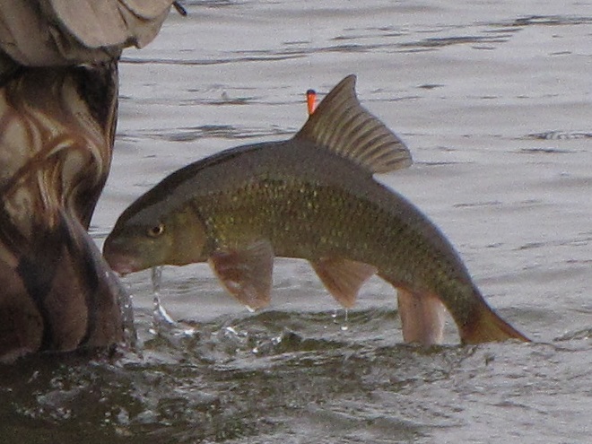
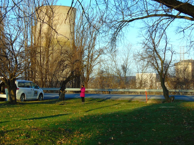
STREAMBED CONDUCTIVE EXCHANGE—In the lower Susquehanna watershed, there may be no better natural example of streambed conductive exchange than the Triassic-Jurassic diabase pothole bedrocks of Conewago Falls on the river at the south end of Three Mile Island.
During sunny days, the massive diabase pothole rocks at Conewago Falls absorb solar (shortwave) radiation, then conduct that heat energy into the flowing water, often continuing to pass the accumulated warmth into the river during the night. On cloudy days, the riverbed collects longwave atmospheric radiation, a heat flux process that yields significantly less energy for conduction into the rapids, riffles, and pools of the falls. During periods of low river flow, the heating effect of streambed conductive exchange can become magnified. Compared to conditions that prevail when torrents of turbid water are rushing through the falls, partially exposed bedrock surrounded by clear water collects radiated energy much more efficiently, then conducts the heat to a greatly reduced volume of passing water. During summer and autumn, this process can create a mix of temperature zones within the falls with warmer water lingering in slow-moving pools and cooler water flowing in the deeper fast-moving channels. Along the falls’ mile-long course, a haven is created for aquatic organisms including warmwater and some coolwater fishes, oft times attracting anglers and a variety of hungry migrating birds as well.Classified as one of our coolwater fishes, the Fallfish finds favorable conditions for feeding, growing, and spawning in the well-oxygenated waters of Conewago Falls.Though the lower Susquehanna River is classified as a warmwater fishery, the Northern Hog Sucker (Hypentelium nigricans), another of our native coolwater fishes, finds the fast-moving waters of Conewago Falls to its liking. Northern Hog Suckers are known to inhabit streams cold enough to host trout. They exhibit remarkable home range fidelity, sometimes spending their entire lives occupying the same several hundred feet of waterway. Northern Hog Suckers are often designated an indicator of good water quality, intolerant of many stream impairment parameters. Their presence in Conewago Falls provides testament to the quality of the warmwater fishery there.An unnatural example. The reduced base flow in this channelized and severely impaired creek has been rendered vulnerable to the negative impacts of several heat flux processes including streambed conductive exchange. Urban stormwater/surfacewater inflow, solar (shortwave) radiation, and heat conducted into the stream from the masonry walls, curbs, and raceway can all conspire to cook aquatic organisms with life-quenching summer water temperatures exceeding 90 degrees Fahrenheit.
SOLAR (SHORTWAVE) RADIATION—The sun provides the energy that fuels the earth’s complex climate. The primary heat flux process that heats our planet is the absorption of solar radiation in the shortwave spectrum, which includes ultraviolet, visible, and infrared frequencies at the upper end of the longwave spectrum. Streams and other bodies of water absorb the greatest amounts of solar (shortwave) radiation during the weeks around summer solstice when the sun at mid-day is closer to zenith than at any other time of the year. However, the heating impact of the radiation may be greatest when the volume of water in the creek, river, or lake is at its minimum for the year—often during early fall.
The rate, measured in watts per square meter, at which solar (shortwave) energy is directly radiated to a given area on the earth’s surface (including streams and other waters) is determined by: solar activity, the angle of the sun in the sky, aspect (slope) of the receiving surface, the opacity of the overlying atmosphere, and the distance of the earth from the sun. The former varies with the year’s seasons, the time of day, and the latitude of a given area. The latter is currently at its annual minimum when earth is at perihelion during the early days of January, thus providing the northern hemisphere with a little bump in radiation during the shortest days of the year when the sun is at its lowest angle in the sky. (NASA image)A varying portion of the solar (shortwave) radiation reaching the earth is reflected back into space by clouds. A smaller share is absorbed by the atmosphere, thus heating it. An even lesser quantity is reflected back into space by water and land. The remainder of the energy is absorbed by the planet’s surfaces, its water and land. (NASA image)
INCIDENT SHORTWAVE RADIATION—Also known as insolation (incoming solar radiation), incident shortwave radiation is the sum total energy of both the direct solar radiation that travels to the earth’s surface unaffected by the atmosphere and the diffuse radiation, waves that have been weakened and scattered by constituents of the atmosphere before reaching the planet’s surface. On a cloudy day, the warming of terrestrial surfaces including streams and other bodies of water is the result of diffuse radiation. On days with any amount of sunshine at all, both direct and diffuse radiation heat our waters and lands.
Warmwater fishes such as the native Pumpkinseed (Lepomis gibbosus) thrive in sun-drenched 70-to-85-degree waters as long as other heat flux processes prevent sudden temperature increases and oxygen depletion.Mowed stream banks offer a waterway no protection from incoming solar (shortwave) radiation, nor terrestrial forms of impairment including nutrient-rich stormwater runoff and silt.
REFLECTED SHORTWAVE RADIATION—known as albedo, reflected solar (shortwave) radiation is energy directed away from the earth’s surface before being absorbed. A surface’s albedo value is basically determined by its color, black having little reflective value, white and silvery surfaces reflecting nearly all solar (shortwave) radiation away. A surface with no reflective properties has an albedo value of 0, while a totally reflective surface has a value of 1. Clean snow with a value of about 0.85 to 0.9 (85% to 90%) is a highly reflective surface; yellow snow isn’t as good. A stream, river, or lake blanketed with ice and snow will absorb very little solar energy and will rely upon other heat flux processes to trigger a melt and thaw. The surface of open water has a varying albedo value determined mostly by the angle of the sun. Solar radiation striking the water’s surface at a low angle is mostly reflected away, while that originating at an angle closer to zenith is more readily absorbed.
To avoid the heating effects of solar (shortwave) and atmospheric longwave radiation, coldwater and coolwater fishes require streams offering protection from full exposure to direct sunlight and cloud cover. Runs and creeks flowing beneath a closed canopy of forest trees are shielded from 25% or more of incoming radiation and are thus able to better maintain thermal stability during the most vulnerable period of the year for temperature-sensitive fishes, May through October.
LONGWAVE RADIATION—Radiation in the longwave spectrum is composed of infrared waves at frequencies lower than those of the shortwave spectrum. Longwave radiation, sometimes just called infrared radiation, is produced by the earth and its atmosphere and is propagated in all directions, day and night. It warms mostly the lower atmosphere which in turn warms the earth’s surface including its waters. Some longwave energy can even be radiated into the waterway from its own streambed—and the stream can return the favor. Other forms of mass surrounding a stream such as a rocky shoreline or a man-made structure such as bridge pier can trade longwave radiation with a waterway. The effect of these latter exchanges is largely trivial and never rivals the heat flux transfer of warm to cold provided by conduction.
Longwave radiation emissions slow as the temperature of the emitting mass decreases, just as they also increase with temperature of the mass. Longwave radiation emissions therefore decrease with altitude along with the temperature of the water vapor, carbon dioxide, methane, and other gases that produce them. As such, the highest reaches of the atmosphere have a greatly reduced capability of shedding longwave radiation into space. At ground level, lakes, creeks, and streams receive their greatest dose of longwave radiation while beneath the cover of low-lying clouds or fog. (NASA image)
CANOPY RADIATION—Trees emit longwave radiation that may have a limited heat flux impact on waterway temperature. This radiation is diffuse, of scattered effect, and scarcely detectable, particularly beneath multilayered dense canopies. Some of the infrared energy transmitted by the tree canopy is radiated skyward as well.
WATER RADIATION—Water, like all earthly matter composed of vibrating molecules, emits longwave radiation. This heat flux process provides an ongoing cooling effect to streams, rivers, lakes, and oceans—warmer ones shedding infrared energy at a faster rate than those that are cold.
Now that we have a basic understanding of the heat flux processes responsible for determining the water temperatures of our creeks and rivers, let’s venture a look at a few graphics from gauge stations on some of the lower Susquehanna’s tributaries equipped with appropriate United States Geological Survey monitoring devices. While the data from each of these stations is clearly noted to be provisional, it can still be used to generate comparative graphics showing basic trends in easy-to-monitor parameters like temperature and stream flow.
Each image is self-labeled and plots stream temperature in degrees Fahrenheit (bold blue) and stream discharge in cubic feet per second (thin blue).
The West Conewago Creek drains much of the Gettysburg Basin’s Triassic redbeds in Adams and northern York Counties in Pennsylvania and includes a small headwaters area in northern Maryland. The gauge station is located just a over a mile upstream from the waterway’s mouth on the Susquehanna just below Conewago Falls. Right through the summer heatwave, this 90-day graph shows a consistent daily pattern of daytime rises in temperature and nighttime cooling. To the right, a rapid cool down can be seen coinciding with two periods of high water, the first from a series of heavy thundershowers, the second from flooding caused by the remnants of Hurricane Debby. Notice that the early August downpours were so heavy that they cooled the hot surface runoff and waterway quickly, without creating a rise in stream temperature at the gauging station. Had this monitoring device been located on a small tributary in an area with an abundance of impervious surfaces, there would probably have been a brief rise in stream temperature prior to the cooldown. (United States Geological Survey image)
The daily oscillations in temperature reflect the influence of several heat flux processes. During the day, solar (shortwave) radiation and convection from summer air, especially those hot south winds, are largely responsible for the daily rises of about 5° F. Longwave radiation has a round-the-clock influence—adding heat to the stream during the day and mostly shedding it at night. Atmospheric exchange including evaporative cooling may help moderate the rise in stream temperatures during the day, and certainly plays a role in bringing them back down after sunset. Along its course this summer, the West Conewago Creek absorbed enough heat to render it a warmwater fishery in the area of the gauging station. The West Conewago is a shallow, low gradient stream over almost its entire course. Its waters move very slowly, thus extending their exposure time to radiated heat flux and reducing the benefit of cooling by atmospheric exchange. Fortunately for bass, catfish, and sunfish, these temperatures are in the ideal range for warmwater fishes to feed, grow, and reproduce—generally over 80° F, and ideally in the 70° to 85° F range. Coolwater fishes though, would not find this stream segment favorable. It was consistently above the 80° F maximum and the 60° to 70° F range preferred by these species. And coldwater fishes, well, they wouldn’t be caught dead in this stream segment. Wait, scratch that—the only way they would be caught in this segment is dead. No trouts or sculpins here.
The Codorus Creek drains primarily the carbonate valleys of York County to the south of the West Conewago watershed. This gauge station is located about a mile upstream from the creek’s mouth on the Susquehanna just below Haldeman Riffles. The graphic pattern is very similar to that of the West Conewago’s: daily heating and cooling cycles and a noticeable drop in stream temperature in early August caused by a day of thundershowers followed by the remnants of Hurricane Debby. (United States Geological Survey image)
Look closely and you’ll notice that although the temperature pattern on this chart closely resembles that of the West Conewago’s, the readings average about 5 degrees cooler. This may seem surprising when one realizes that the Codorus follows a channelized path through the heart of York City and its urbanized suburbs—a heat island of significance to a stream this size. Before that it passes through numerous impoundments where its waters are exposed to the full energy of the sun. The tempering factor for the Codorus is its baseflow. Despite draining a smaller watershed than its neighbor to the north, the Codorus’s baseflow (low flow between periods of rain) was 96 cubic feet per second on August 5th, nearly twice that of the West Conewago (51.1 cubic feet per second on August 5th). Thus, the incoming heat energy was distributed over a greater mass in the Codorus and had a reduced impact on its temperature. Though the Codorus is certainly a warmwater fishery in its lower reaches, coolwater and transitional fishes could probably inhabit its tributaries in segments located closer to groundwater sources without stress. Several streams in its upper reaches are in fact classified as trout-stocked fisheries.
This is a zoomed-in look at the previous graph showing the impact of a rainfall event on the water temperatures in Codorus Creek. Unlike the sharp declines accompanying the deluge of flood waters during the two events in early August, these lesser storms in late June generated just enough runoff to capture heat energy from impervious surfaces and warm the creek, temporarily breaking the daily heating/cooling cycle. Upstream in the immediate area of the runoff, the impact on the stream and/or its tributaries was probably much more dramatic, certainly raising temperatures into the nineties or above. (United States Geological Survey image)Kreutz Creek drains a carbonate bedrock area of York County and flows parallel to the Lincoln Highway (US 30) to enter the Susquehanna at Wrightsville. The gauging station is about one mile upstream from the creek’s mouth. (United States Geological Survey image)
The Kreutz Creek gauge shows temperature patterns similar to those in the West Conewago and Codorus data sets, but notice the lower overall temperature trend and the flow. Kreutz Creek is a much smaller stream than the other two, with a flow averaging less than one tenth that of the West Conewago and about one twentieth of that in the Codorus. And most of the watershed is cropland or urban/suburban space. Yet, the stream remains below 80° F through most of the summer. The saving graces in Kreutz Creek are reduced exposure time and gradient. The waters of Kreutz Creek tumble their way through a small watershed to enter the Susquehanna within twenty-four hours, barely time to go through a single daily heating and cooling cycle. As a result, their is no chance for water to accumulate radiant and convective heat over multiple summer days. The daily oscillations in temperature are less amplified than we find in the previous streams—a swing of about three degrees compared to five. This indicates a better balance between heat flux processes that raise temperature and those that reduce it. Atmospheric exchange in the stream’s riffles, forest cover, and good hyporheic exchange along its course could all be tempering factors in Kreutz Creek. From a temperature perspective, Kreutz Creek provides suitable waters for coolwater fishes.
Muddy Creek drains portions of southern York County through rolling farmland and woodlots. There are no large impoundments or widespread urban impacts in the watershed, which may help explain its slightly lower temperature trends. (United States Geological Survey image)
Muddy Creek is a trout-stocked fishery, but it cannot sustain coldwater species through the summer heat. Though temperatures in Muddy Creek may be suitable for coolwater fishes, silt, nutrients, low dissolved oxygen, and other factors could easily render it strictly a warmwater fishery, inhabited by species tolerant of significant stream impairment.
Chiques Creek drains mostly limestone farmland in northwestern Lancaster County. The gauging station is located near the stream’s mouth on the Susquehanna at Chiques (Chickies) Rock. Oscillations in temperature again resemble the other waterways, but daily highs remain almost entirely below 80 degrees. (United States Geological Survey image)
A significant number of stream segments in the Chiques watershed have been rehabilitated to eliminate intrusion by grazing livestock, cropland runoff, and other sources of impairment. Through partnerships between a local group of watershed volunteers and landowners, one tributary, Donegal Creek, has seen riparian buffers, exclusion fencing, and other water quality and habitat improvements installed along nearly ever inch of its run from Donegal Springs through high-intensity farmland to its mouth on the main stem of the Chiques just above its confluence with the Susquehanna. The improved water quality parameters in the Donegal support native coldwater sculpins and an introduced population of reproducing Brown Trout. While coldwater habitat is limited to the Donegal, the main stem of the Chiques and its largest tributary, the Little Chiques Creek, both provide suitable temperatures for coolwater fishes.
Streams in the Chiques Creek and similar limestone watersheds often pass through areas with significant bedrock formations. Heat flux processes including groundwater input, hyporheic exchange, and streambed conductive exchange can have a greater influence on water temperature along these segments.A breeding condition Eastern Balcknose Dace, one of the coldwater transition fishes found in the Chiques and its tributaries.The Common Shiner (Luxilus cornutus), a fish tolerant of warmwater streams, prefers cool, clear waters for spawning. For protection from late-spring and summer heat, breeding males may seek a section of creek with a streambed inflow of limestone groundwater to defend as their nesting territory.A closeup of the Chiques Creek graph showing what appears to be a little bump in temperature caused by surface runoff during a couple of late-May showers. Stream rehabilitation is an ongoing process and the pressures of land disturbances both old and new present challenges to those who make it their passion to fix the wrongs that have been inflicted upon our local waters. Even the exemplary Donegal Creek faces new threats from urbanization in one of its headwater areas several miles to the northwest of the historic springs. (United States Geological Survey image)Conewago Creek (East) drains primarily Triassic redbed farmlands in Dauphin, Lancaster, and Lebanon Counties. Much of the headwaters area is forested but is experiencing an increasing rate of encroachment by housing and some commercial development. Conewago Creek (East) enters the Susquehanna on the east side of Conewago Falls at Three Mile Island. The watershed is equipped with three U.S.G.S. gauge stations capable of providing temperature data. This first one is located just over a mile upstream of the creek’s mouth. (United States Geological Survey image)
Despite its meander through and receipt of water from high-intensity farmland, the temperature of the lower Conewago (East) maxes out at about 85° F, making it ideal for warmwater fishes and even those species that are often considered coolwater transition fishes like introduced Smallmouth Bass, Rock Bass, Walleye, and native Margined Madtom. This survivable temperature is a testament to the naturally occurring and planted forest buffers along much of the stream’s course, particularly on its main stem. But the Conewago suffers serious baseflow problems compared to other streams we’ve looked at so far. Just prior to the early August storms, flow was well below 10 cubic feet per second for a drainage area of more than fifty square miles. While some of this reduced flow is the result of evaporation, much of it is anthropogenic in origin as the rate of groundwater removal continues to increase and a recent surge in stream withdraws for irrigation reaches its peak during the hottest days of summer.
A juvenile Rock Bass.A juvenile Margined Madtom.A closer look at the Conewago Creek (East) graphic shows the temperature drop associated with a series of thundershowers and the remnants of Hurricane Debby in early August. Despite the baseflow being below five cubic feet per second, the cooling effect of the downpours as measured in the area of the gauge was significant enough to overwhelm any heating of runoff that may have occurred as precipitation drained across hardened soils or man-made impervious surfaces. (United States Geological Survey image)
A little side note—the flow rate on the Conewago at the Falmouth gauge climbed to about 160 cubic feet per second as a result of the remnants of Hurricane Debby while the gauge on the West Conewago at Manchester skyrocketed to about 20,000 cubic feet per second. Although the West Conewago’s watershed (drainage area) is larger than that of the Conewago on the east shore, it’s larger only by a multiple of two or three, not 125. That’s a dramatic difference in rainfall!
The Bellaire monitoring station on Conewago Creek (East) is located on the stream’s main stem just downstream from the mouth of Little Conewago Creek, a tributary with its origins in farmland and woodlots. (United States Geological Survey image)
The temperatures at the Bellaire monitoring station, which is located upstream of the Conewago’s halfway point between its headwaters in Mount Gretna and its mouth, are quite comparable to those at the Falmouth gauge. Although a comparison between these two sets of data indicate a low net increase in heat absorption along the stream’s course between the two points, it also suggests sources of significant warming upstream in the areas between the Bellaire gauge and the headwaters.
Data from the gauge site on the Little Conewago Creek shows a temperature averaging about five degrees cooler than the gauge several miles downstream on the main stem of the Conewago at Bellaire. (United States Geological Survey image)
The waters of the Little Conewago are protected within planted riparian buffers and mature woodland along much of their course to the confluence with the Conewago’s main stem just upstream of Bellaire. This tributary certainly isn’t responsible for raising the temperature of the creek, but is instead probably helping to cool it with what little flow it has.
A stream like the Little Conewago Creek with daily temperatures that remain mostly below 80 degrees and retreat to 75 degrees or less during the night can be suitable for coldwater transition fishes like these juvenile Eastern Blacknose Dace (top) and Longnose Dace.
Though mostly passing through natural and planted forest buffers above its confluence with the Little Conewago, the main stem’s critically low baseflow makes it particularly susceptible to heat flux processes that raise stream temperatures in segments within the two or three large agricultural properties where owners have opted not to participate in partnerships to rehabilitate the waterway. The headwaters area, while largely within Pennsylvania State Game Lands, is interspersed with growing residential communities where potable water is sourced from hundreds of private and community wells—every one of them removing groundwater and contributing to the diminishing baseflow of the creek. Some of that water is discharged into the stream after treatment at the two municipal sewer plants in the upper Conewago. This effluent can become quite warm during processing and may have significant thermal impact when the stream is at a reduced rate of flow. A sizeable headwaters lake is seasonally flooded for recreation in Mount Gretna. Such lakes can function as effective mid-day collectors of solar (shortwave) radiation that both warms the water and expedites atmospheric exchange.
The Conewago Creek (East) Watershed from the Bellaire U.S.G.S. Gauging Station (lower left) upstream to the headwaters in Mount Gretna. (United States Geological Survey image)
Though Conewago Creek (East) is classified as a trout-stocked fishery in its upper reaches in Lebanon County, its low baseflow and susceptibility to warming render it inhospitable to these coldwater fishes by late-spring/early summer.
Despite being considered a warmwater fish, the River Chub (Nocomis micropogon) will ascend streams like the Conewago to seek cooler, gravel-bottomed waters for spawning. Reduced baseflow has probably rendered the stream currently too small for this species on Pennsylvania State Game Lands in Colebrook where this specimen was photographed in 2018.The Golden Shiner, another warmwater fish, often ascends streams to enter cooler water. Juvenile Golden Shiners like this one will move into shallower headwaters not only to seek reduced temperatures, but to escape large predatory fishes as well.Irrigation of agricultural fields using a large portion of the already diminished baseflow in the Conewago Creek (East) just downstream of the Bellaire gauging station. Despite millions of dollars in investment to rehabilitate this Susquehanna valley stream, the riparian buffers and other practices can have little effect when the creek gets sucked down to just a trickle. Low baseflow is a hard nut to crack. It’s best prevented, not corrected.Hammer Creek, a trout-stocked fishery, originates, in part, within Triassic conglomerate in the Furnace Hills of Lebanon County, then flows north into the limestone Lebanon Valley where it picks up significant flow from other tributaries before working its way south back through the Furnace Hills into the limestone farmlands of Lancaster County. From there the stream merges with the Cocalico Creek, then the Conestoga River, and at last the Susquehanna. Note the tremendous daily temperature oscillations on this headwaters stream as it surges about 15 degrees each day before recovering back close to groundwater temperature by sunrise the next day. (United States Geological Survey image)Headwaters of Hammer Creek including Buffalo Springs, a significant source of cold groundwater feeding the western leg of the stream. The large dams on this section that created the Lebanon and Rexmont Reservoirs have been removed. (United States Geological Survey base image)
The removal of two water supply dams on the headwaters of Hammer Creek at Rexmont eliminated a large source of temperature fluctuation on the waterway, but did little to address the stream’s exposure to radiant and convective heat flux processes as it meanders largely unprotected out of the forest cover of Pennsylvania State Game Lands and through high-intensity farmlands in the Lebanon Valley. Moderating the temperature to a large degree is the influx of karst water from Buffalo Springs, located about two miles upstream from this gauging station, and other limestone springs that feed tributaries which enter the Hammer from the east and north. Despite the cold water, the impact of the stream’s nearly total exposure to radiative and other warming heat flux processes can readily be seen in the graphic. Though still a coldwater fishery by temperature standards, it is rather obvious that rapid heating and other forms of impairment await these waters as they continue flowing through segments with few best management practices in place for mitigating pollutants. By the time Hammer Creek passes back through the Furnace Hills and Pennsylvania State Game Lands, it is leaning toward classification as a coolwater fishery with significant accumulations of sediment and nutrients. But this creek has a lot going for it—mainly, sources of cold water. A core group of enthusiastic landowners could begin implementing the best management practices and undertaking the necessary water quality improvement projects that could turn this stream around and make it a coldwater treasure. An organized effort is currently underway to do just that. Visit Trout Unlimited’s Don Fritchey Chapter and Donegal Chapter to learn more. Better yet, join them as a volunteer or cooperating landowner!
The male Creek Chub, one of our coolwater fishes, develops head tubercles and becomes flushed with color during spawning season. Hammer Creek not only provides a home for the Creek Chub, its cold headwaters provide refuge for a population of native Brook Trout too.Like no other example we’ve looked at so far, this closeup of the Hammer Creek graphic shows temperature bumps correlating with the stormwater runoff from early August’s rains. Because the stream flow is small and the precipitation rate was not as great at this location, the effect of heat flux from runoff is more readily apparent. (United States Geological Survey image)Brook Trout adult and juvenile. (United States Fish and Wildlife Service image by Ryan Hagerty)
For coldwater fishes, the thousands of years since the most recent glacial maximum have seen their range slowly contract from nearly the entirety of the once much larger Susquehanna watershed to the headwaters of only our most pristine streams. Through no fault of their own, they had the misfortune of bad timing—humans arrived and found coldwater streams and the groundwater that feeds them to their liking. Some of the later arrivals even built their houses right on top of the best-flowing springs. Today, populations of these fishes in the region we presently call the Lower Susquehanna River Watershed are seriously disconnected and the prospect for survival of these species here is not good. Stream rehabilitation, groundwater management, and better civil planning and land/water stewardship are the only way coldwater fishes, and very possibly coolwater fishes as well, will survive. For some streams like Hammer Creek, it’s not too late to make spectacular things happen. It mostly requires a cadre of citizens, local government, project specialists, and especially stakeholders to step up and be willing to remain focused upon project goals so that the many years of work required to turn a failing stream around can lead to success.
Riparian buffers with fences to exclude livestock can immediately begin improving water quality. With establishment of such vegetative buffers, the effects of stressors that otherwise eliminate coldwater and coolwater fishes from these segments will begin to diminish.Within five to ten years, a riparian buffer planted with native trees is not only helping to reduce nutrient and sediment loads in the stream, it is also shielding the waters from heat flux processes including the solar (shortwave) radiation that raises water temperatures to levels not tolerated by coldwater and coolwater fishes.A well-established riparian buffer.A forested stream.
You’re probably glad this look at heat flux processes in streams has at last come to an end. That’s good, because we’ve got a lot of work to do.
Add one more benefit to the wildflower meadow, it infiltrates stormwater to recharge the aquifer much better than mowed grass. And another related plus, it reduces runoff and its thermal pollution. Besides, you don’t have time to mow grass, because we have work to do!Our native coldwater fishes including the Potomac Sculpin will survive only if we protect and expand the scattered few habitats where they have taken refuge. They have no choice but to live in these seriously threatened places, but we do. So let’s give ’em some space. How ’bout it? (United States Fish and Wildlife Service image by Ryan Hagerty)
Tuesday’s collision of the container ship Dali into Baltimore’s Francis Scott Key Bridge and the nearly immediate collapse of the span into the chilly waters below reminds us just how unforgiving and deadly maritime accidents can be. Upon termination of rescue and recovery operations, salvage and cleanup will be prioritized as the next steps in the long-term process of reopening the navigable waters to ship traffic and construction of a new bridge. Part of the effort will include monitoring for leaks of fuels and other hazardous materials from the ship, its damaged cargo containers, and vehicles and equipment that were on the bridge when it failed.
Damage to the hull of the Dali and to the cargo containers on her deck could lead to leaks of hazardous liquids or other materials into Chesapeake Bay. (United States Army Corps of Engineers Baltimore image)
On the waters and shores of today’s Chesapeake, numerous county, state, and federal agencies, including the United States Coast Guard, monitor and inspect looking for conditions and situations that could lead to point-source or accidental discharges of petroleum products and other hazardous materials into the bay. Many are trained, equipped, and organized for emergency response to contain and mitigate spills upon detection. But this was not always the case.
Through much of the twentieth century, maritime spills of oil and other chemicals magnified the effects of routine discharges of hazardous materials and sanitary sewer effluent into the Chesapeake and its tributaries. The cumulative effect of these pollutants progressively impaired fisheries and bay ecosystems leading to noticeable declines in numbers of many aquatic species. Rather frequently, spills or discharges resulted in conspicuous fish and/or bird kills.
One of the worst spills occurred near the mouth of the Potomac River on February 2, 1976, when a barge carrying 250,000 gallons of number 6 oil sank in a storm and lost its cargo into the bay. During a month-long cleanup, the United States Coast Guard recovered approximately 167,000 gallons of the spilled oil, the remainder dispersed into the environment. A survey counted 8,469 “sea ducks” killed. Of the total number, the great majority were Horned Grebes (4,347 or 51.3%) and Long-tailed Ducks (2,959 or 34.9%). Other species included Surf Scoter (Melanitta perspicillata) (405 or 4.8%), Common Loon (195 or 2.3%), Bufflehead (166 or 2.0%), Ruddy Duck (107 or 1.3%), Common Goldeneye (78 or 0.9%), Tundra Swan (46 or 0.5%), Greater Scaup (19 or 0.2%), American Black Duck (12 or 0.2%), Common Merganser (11 or 0.1%), Canvasback (10 or 0.1%), Double-crested Cormorant (10 or 0.1%), Canada Goose (8 or 0.1%), White-winged Scoter (Melanitta deglandi) (7 or 0.1%), Redhead (5 or 0.1%), gull species (10 or 0.1%), miscellaneous ducks and herons (13 or 0.2%) and unidentified (61 or 0.7%). During the spring migration, a majority of these birds would have made their way north and passed through the lower Susquehanna valley. The accident certainly impacted the occurrence of the listed species during that spring in 1976, and possibly for a number of years after.
Of the 8,469 birds killed by the February 2, 1976, oil spill on the Chesapeake, 51.3% (4,347) were Horned Grebes. Many of them would have migrated north through the Lower Susquehanna River Watershed during the coming spring.
The Federal Water Pollution Control Act Amendments of 1972, commonly known as the Clean Water Act, put teeth into the original FWCPCA of 1948 and began reversing the accumulation of pollutants in the bay and other bodies of water around the nation. Additional amendments in 1977 and 1987 have strengthened protections and changed the culture of “dump-and-run” disposal and “dilution-is-the-solution” treatment of hazardous wastes. During the late nineteen-seventies and early nineteen-eighties, emergency response teams and agencies began organizing to control and mitigate spill events. The result has been a greater awareness and competency for handling accidental discharges of fuels and other chemicals into Chesapeake Bay and other waterways. These improvements can help minimize the environmental impact of the Dali’s collision with the Francis Scott Key Bridge in Baltimore.
Oil spills and other pollution in the Chesapeake can impact populations of migratory fish including the anadromous Hickory Shad which are presently transiting the bay on their way to the waters of the Susquehanna below Conowingo Dam.
SOURCES
Roland, John V., Moore, Glenn E., and Bellanca, Michael A. 1977. “The Chesapeake Bay Oil Spill—February 2, 1976: A Case History”. International Oil Spill Conference Proceedings (1977). 1977 (1): 523-527.
As week-old snow and ice slowly disappears from the Lower Susquehanna River Watershed landscape, we ventured out to see what might be lurking in the dense clouds of fog that for more than two days now have accompanied a mid-winter warm spell.
After freezing to a slushy consistency earlier this week, the Susquehanna is already beginning to thaw. Below the York Haven Dam at Conewago Falls, the water is open and ice-free.On frozen man-made lakes and ponds, geese and ducks like these Mallards and American Wigeon are presently concentrated around small pockets of open water.During the past ten days, American Robin numbers have exploded throughout the lower Susquehanna valley. The majority of these birds may be a mix of both those coming south to escape the late onset of wintry conditions to our north and those inching north into our region as early spring migrants.The January thaw has melted the snow from lawns and fields to provide thousands of visiting robins with a chance to forage for earthworms.A visit by this young Cooper’s Hawk to the susquehannnawildlife.net headquarters garden sent songbirds scrambling……but did nothing to unnerve our resident Eastern Gray Squirrels,……which promptly went into tail-waving mode to advertise their presence.But earlier in the week, when heavy snow cover in the rural areas surrounding our urbanized neighborhood made it difficult for rodent-eating raptors to find food, we received brief visits from both a Red-tailed Hawk……and this young Red-shouldered Hawk, an uncommon bird of prey most often found in wet woods and other lowlands.To escape notice during visits by these larger raptors, our squirrels remained motionless and commenced performance of their best bump-on-a-log impressions.Unimpressed, each of our visiting buteos remained for just a few minutes before moving on in search of more favorable hunting grounds and prey.As snow melted and exposed bare ground in fields of early successional growth, we encountered……a flock of White-crowned Sparrows, most in first-winter plumage……and at least a dozen American Tree Sparrows. During the twentieth century, these handsome songbirds were regular winter visitors to the lower Susquehanna region. During recent decades, they’ve become increasingly more difficult to find. Currently, moderate numbers appear to be arriving to escape harsher weather to our north.What could be more appropriate on a foggy, gray evening than finding a “gray ghost” (adult male Northern Harrier) patrolling the fields in search of mice and voles.
If scenes of a January thaw begin to awaken your hopes and aspirations for all things spring, then you’ll appreciate this pair of closing photographs…
The maroon-red flower buds of Silver Maples are beginning to swell. And woodpeckers including Pileated Woodpeckers are beginning to drum, a timber-pounding behavior they use to establish breeding territories in habitats with suitable sites for cavity nesting.In wet soil surrounding spring seeps and streams, Skunk Cabbage is rising through the leaf litter to herald the coming of a new season. Spring must surely be just around the corner.
The last of the year’s migrating Bald Eagles are streaming down the ridges of the mid-Atlantic region and many of them will be stopping for at least a part of the winter season along the lower Susquehanna River. If you want to see them, now is the best time. Taking a walk along a riverside recreation trail is a relaxing way to spend some time checking them out. To see the greatest concentrations of these majestic birds, plan a visit to one of the lower river’s hydroelectric dams. Conowingo Dam, located where U.S. Route 1 crosses the river at Rising Sun, Maryland, is currently hosting dozens of visiting eagles. If you’ve never been there, we can assure you that it’s certainly worth the trip.
Mid-summer can be a less than exciting time for those who like to observe wild birds. The songs of spring gradually grow silent as young birds leave the nest and preoccupy their parents with the chore of gathering enough food to satisfy their ballooning appetites. To avoid predators, roving families of many species remain hidden and as inconspicuous as possible while the young birds learn how to find food and handle the dangers of the world.
But all is not lost. There are two opportunities for seeing unique birds during the hot and humid days of July.
First, many shorebirds such as sandpipers, plovers, dowitchers, and godwits begin moving south from breeding grounds in Canada. That’s right, fall migration starts during the first days of summer, right where spring migration left off. The earliest arrivals are primarily birds that for one reason on another (age, weather, food availability) did not nest this year. These individuals will be followed by birds that completed their breeding cycles early or experienced nest failures. Finally, adults and juveniles from successful nests are on their way to the wintering grounds, extending the movement into the months we more traditionally start to associate with fall migration—late August into October.
For those of you who find identifying shorebirds more of a labor than a pleasure, I get it. For you, July can bring a special treat—post-breeding wanderers. Post-breeding wanderers are birds we find roaming in directions other than south during the summer months, after the nesting cycle is complete. This behavior is known as “post-breeding dispersal”. Even though we often have no way of telling for sure that a wandering bird did indeed begin its roving journey after either being a parent or a fledgling during the preceding nesting season, the term post-breeding wanderer still applies. It’s a title based more on a bird sighting and it’s time and place than upon the life cycle of the bird(s) being observed. Post-breeding wanderers are often southern species that show up hundreds of miles outside there usual range, sometimes traveling in groups and lingering in an adopted area until the cooler weather of fall finally prompts them to go back home. Many are birds associated with aquatic habitats such as shores, marshes, and rivers, so water levels and their impact on the birds’ food supplies within their home range may be the motivation for some of these movements. What makes post-breeding wanderers a favorite among many birders is their pop. They are often some of our largest, most colorful, or most sought-after species. Birds such as herons, egrets, ibises, spoonbills, stilts, avocets, terns, and raptors are showy and attract a crowd.
While it’s often impossible to predict exactly which species, if any, will disperse from their typical breeding range in a significant way during a given year, some seem to roam with regularity. Perhaps the most consistent and certainly the earliest post-breeding wanderer to visit our region is the “Florida Bald Eagle”. Bald Eagles nest in “The Sunshine State” beginning in the fall, so by early spring, many of their young are on their own. By mid-spring, many of these eagles begin cruising north, some passing into the lower Susquehanna valley and beyond. Gatherings of dozens of adult Bald Eagles at Conowingo Dam during April and May, while our local adults are nesting and after the wintering birds have gone north, probably include numerous post-breeding wanderers from Florida and other Gulf Coast States.
So this week, what exactly was it that prompted hundreds of birders to travel to Middle Creek Wildlife Management Area from all over the Mid-Atlantic States and from as far away as Colorado?
Birders observing something special at Middle Creek Wildlife Management Area on July 10, 2023.
Was it the majestic Great Blue Herons and playful Killdeer?
Great Blue Heron and a Killdeer.
Was it the colorful Green Herons?
Green Heron
Was it the Great Egrets snapping small fish from the shallows?
Great Egret
Was it the small flocks of shorebirds like these Least Sandpipers beginning to trickle south from Canada?
Least Sandpipers
All very nice, but not the inspiration for traveling hundreds or even thousands of miles to see a bird.
It was the appearance of this very rare post-breeding wanderer…
A Limpkin at Middle Creek Wildlife Management Area in Lancaster County. The Limpkin (Aramus guarauna) is the only surviving member of the family Aramidae.
…Pennsylvania’s first record of a Limpkin, a tropical wading bird native to Florida, the Caribbean Islands, and South America. Many observers visiting Middle Creek Wildlife Management Area had never seen one before, so if they happen to be a “lister”, a birder who keeps a tally of the wild bird species they’ve seen, this Limpkin was a “lifer”.
The Limpkin is an inhabitant of vegetated marshlands where it feeds almost exclusively upon large snails of the family Ampullariidae, including the Florida Applesnail (Pomacea paludosa), the largest native freshwater snail in the United States.
In the United States, the native range of the Limpkin lies within the native range of the Florida Applesnail, shown here in gold. Introduced populations of the snail are shown in brown. (United States Geological Survey Nonindigenous Aquatic Species image)A spectacular nineteenth-century rendition of the Florida Applesnail, including an egg mass, illustrated by Helen E. Lawson in Samuel S. Haldeman’s “Monograph of the Freshwater Univalve Mollusca of the United States”.
Observations of the Limpkin lingering at Middle Creek Wildlife Management Area have revealed a pair of interesting facts. First, in the absence of Florida Applesnails, this particular Limpkin has found a substitute food source, the non-native Chinese Mystery Snail (Cipangopaludina chinensis). And second, Chinese Mystery Snails have recently become established in the lakes, pools, and ponds at the refuge, very likely arriving as stowaways on Spatterdock (Nupharadvena) and/or American Lotus (Nelumbo lutea), native transplants brought in during recent years to improve wetland habitat and process the abundance of nutrients (including waterfowl waste) in the water.
The Chinese Mystery Snail is the largest freshwater snail in the Lower Susquehanna River Watershed. (Vintage 35 mm image)By hitching a ride on aquatic transplants like this Spatterdock, non-native freshwater snails are easily vectored into new areas outside their previous range.Spatterdock, a native species also known as Yellow Pond Lily or Cow Lily, flowering in August.Blooming American Lotus transplants in a pool at Middle Creek Wildlife Management Area during August.The Limpkin at Middle Creek W.M.A. capturing a Chinese Mystery Snail.The Limpkin at Middle Creek carrying a Chinese Mystery Snail.The Limpkin is seen here maneuvering the the snail in its bill, a set of mandibles specially adapted for extracting the bodies of large freshwater snails from their shells.The tweezers-like tip of the bill is used to grasp the shell by the rim of the opening or by the “trapdoor” (operculum) that protects the snail inside.A posed Chinese Mystery Snail showing its “trapdoor”, the operculum protecting the soft body tissue when the animal withdraws inside. The tips of the Limpkin’s bill close tightly like the end of a tweezers to grasp the operculum and remove it and the snail’s body from the shell. (Vintage 35 mm image)The tweezers-tipped bill, which is curved slightly to the right in some Limpkins, is slid into the shell to grasp the snails body and remove it for consumption. The entire extraction process takes 10 to 30 seconds.
The Middle Creek Limpkin’s affinity for Chinese Mystery Snails may help explain how it was able to find its way to Pennsylvania in apparent good health. Look again at the map showing the range of the Limpkin’s primary native food source, the Florida Applesnail. Note that there are established populations (shown in brown) where these snails were introduced along the northern coast of Georgia and southern coast of South Carolina…
Native (gold) and non-native (brown) ranges of the Florida Applesnail. (United States Geological Survey Nonindigenous Aquatic Species image)
…now look at the latest U.S.G.S. Nonindigenous Aquatic Species map showing the ranges (in brown) of established populations of non-native Chinese Mystery Snails…
Range (in brown) of established populations of non-native Chinese Mystery Snails. (United States Geological Survey Nonindigenous Aquatic Species image)
…and now imagine that you’re a happy-go-lucky Limpkin working your way up the Atlantic Coastal Plain toward Pennsylvania and taking advantage of the abundance of food and sunshine that summer brings to the northern latitudes. It’s a new frontier. Introduced populations of Chinese Mystery Snails are like having a Waffle House serving escargot at every exit along the way!
Be sure to click the “Freshwater Snails” tab at the top of this page to learn more about the Chinese Mystery Snail and its arrival in the Lower Susquehanna River Watershed. Once there, you’ll find some additional commentary about the Limpkin and the likelihood of Everglade Snail Kites taking advantage of the presence of Chinese Mystery Snails to wander north. Be certain to check it out.
The endangered Everglade Snail Kite (Rostrhamus sociabilis plumbeus), a Florida Applesnail specialist, has survived in part due to its ability to adapt to eating the non-native Pomacea maculata applesnails which have become widespread in Florida following releases from aquaria. The adaptation?…a larger body and bill for eating larger snails. (National Park Service image)
A juvenile Ring-billed Gull with a freshly caught Gizzard Shad is pursued by a hungry adult Great Black-backed Gull on the Susquehanna at Conowingo Dam.
First there was the Nautilus. Then there was the Seaview. And who can forget the Yellow Submarine? Well, now there’s the S. S. Haldeman, and today we celebrated her shakedown cruise and maiden voyage. The Haldeman is powered by spent fuel that first saw light of day near Conewago Falls at a dismantled site that presently amounts to nothing more than an electrical substation. Though antique in appearance, the vessel discharges few emissions, provided there aren’t any burps or hiccups while underway. So, climb aboard as we take a cruise up the Susquehanna at periscope depth to have a quick look around!
Brunner Island as seen from the east channel.Close-in approach to emergent Water Willow growing on an alluvial Island.The approach to York Haven Dam and Conewago Falls from the west channel.A pair of Powdered Dancers on a midriver log.
Watertight and working fine. Let’s flood the tanks and have a peek at the benthos. Dive, all dive!
American Eelgrass, also known as Tapegrass, looks to be growing well in the channels. Historically, vast mats of this plant were the primary food source for the thousands of Canvasback ducks that once visited the lower Susquehanna each autumn.As is Water Stargrass (Heteranthera dubia). When mature, both of these native plants provide excellent cover for young fish. Note the abundance of shells from deceased Asiatic Clams (Corbicula fluminea) covering the substrate.A three-tailed mayfly (Ephemeroptera) nymph and a several exoskeletons cling to the downstream side of a rock.This hollowed-out stick may be a portable protective shelter belonging to a Comb-lipped Casemaker Caddisfly larva (Calamoceratidae). The larva itself appears to be extending from the end of the “case” in the upper right of the image. Heteroplectron americanum, a species known for such behavior, is a possibility. In the Susquehanna and its tributaries, the Rusty Crayfish (Faxonius rusticus) is an introduced invasive species. It has little difficulty displacing native species due to its size and aggressiveness.A Rusty Crayfish.Summers with conditions that promote eelgrass and stargrass growth tend to be big years for Virginian River Horn Snails (Elimia virginica). 2022 appears to be one of those years. They’re abundant and they’re everywhere on the rocks and gravel substrate in midriver. Feeding almost incessantly on algae and detritus, these snails are an essential component of the riverine ecosystem, breaking down organic matter for final decomposition by bacteria and fungi.Bits of debris suspended in the flowing water streak by this Virginian River Horn Snail. The spire-shaped shell is a streamlining adaptation for maneuvering and holding fast in the strong current.A young Virginian River Horn Snail following a mature adult. Note the green algae growing among the decaying plant and animal remains that blanket the river bottom.Two of a population that may presently include millions of Virginian River Horn Snails living downstream of Conewago Falls.Virginian River Horn Snails with Lesser Mystery Snails (Campeloma decisum), another native species commonly encountered at Conewago Falls and in surrounding waters.A River Snail (Leptoxis carinata), also known as a Crested Mudalia, hitching a ride on a Virginian River Horn Snail. The two species are frequently found together.A River Snail cleaning the shell of a native freshwater Unionidae mussel, Lampsilis cariosa, commonly called the Yellow Lampmussel or Carried Lampmussel. Because of their general decline in abundance and range, all Unionidae mussels are protected in Pennsylvania.The Banded Darter (Etheostoma zonale) is a member of the perch family (Percidae).A Smallmouth Bass in strong current.Along the edge of an alluvial island at midriver, Cyprinella (Spotfin or Satinfin) Shiners gather in the cover of an emergent stand of Water Willow. The closely related Spotfin Shiner (Cyprinella spiloptera) and Satinfin Shiner (Cyprinella analostanus) are nearly impossible to differentiate in the field.A breeding condition male Cyprinella (Spotfin or Satinfin) Shiner.A juvenile Channel Catfish.
We’re finding that a sonar “pinger” isn’t very useful while running in shallow water. Instead, we should consider bringing along a set of Pings—for the more than a dozen golf balls seen on the river bottom. It appears they’ve been here for a while, having rolled in from the links upstream during the floods. Interestingly, several aquatic species were making use of them.
River Snail cleaning a golf ball.A golf ball used as an anchor point for silk cases woven by Net-spinning Caddisfly (Hydropsychidae) larvae to snare food from the water column.A Creeping Ancylid (Ferrissia species), a tiny gastropod also known as a Coolie Hat Snail, River Limpet, or Brook Freshwater Limpet, inhabits the dimple on a “Top Flight”.A closeup view of the Creeping Ancylid. The shell sits atop the snail’s body like a helmet.We now know why your golf balls always end up in the drink, it’s where they go to have their young.
Well, it looks like the skipper’s tired and grumpy, so that’s all for now. Until next time, bon voyage!
Fifty years ago this week, the remnants of Hurricane Agnes drifted north through the Susquehanna River basin as a tropical storm and saturated the entire watershed with wave after wave of torrential rains. The storm caused catastrophic flooding along the river’s main stem and along many major tributaries. The nuclear power station at Three Mile Island, then under construction, received its first major flood. Here are some photos taken during the climax of that flood on June 24, 1972. The river stage as measured just upstream of Three Mile Island at the Harrisburg gauge crested at 33.27 feet, more than 10 feet above flood stage and almost 30 feet higher than the stage at present. At Three Mile Island and Conewago Falls, the river was receiving additional flow from the raging Swatara Creek, which drains much of the anthracite coal region of eastern Schuylkill County—where rainfall from Agnes may have been the heaviest.
1972- From the river’s east shore at the mouth of Conewago Creek, Three Mile Island’s “south bridge” crosses the Susquehanna along the upstream edge of Conewago Falls. The flood crested just after covering the roadway on the span. Floating debris including trees, sections of buildings, steel drums, and rubbish began accumulating against the railings on the bridge’s upstream side, leading observers to speculate that the span would fail. When a very large fuel tank, thousands of gallons in capacity, was seen approaching, many thought it would be the straw that would break the camel’s back. It wasn’t, but the crashing sounds it made as it struck the bridge then turned and began rolling against the rails was unforgettable. (Larry L. Coble, Sr. image)1972- In this close-up of the preceding photo, the aforementioned piles of junk can be seen along the upstream side of the bridge (behind the sign on the right). The fuel tank struck and was rolling on the far side of this pile. (Larry L. Coble, Sr. image)2022- Three Mile Island’s “south bridge” as it appeared this morning, June 24,2022.1972- The railroad along the east shore at Three Mile Island’s “south bridge” was inundated by rising water. This flooded automobile was one of many found in the vicinity. Some of these vehicles were overtaken by rising water while parked, others were stranded while being driven, and still others floated in from points unknown. (Larry L. Coble, Sr. image)2022- A modern view of the same location.1972- At the north end of Three Mile Island, construction on Unit 1 was halted. The completed cooling towers can be seen to the right and the round reactor building can be seen behind the generator building to the left. The railroad grade along the river’s eastern shore opposite the north end of the island was elevated enough for this train to stop and shelter there for the duration of the flood. (Larry L. Coble, Sr. image)2022- Three Mile Island Unit 1 as it appears today: shut down, defueled, and in the process of deconstruction.1972- In March of 1979, the world would come to know of Three Mile Island Unit 2. During Agnes in June of 1972, flood waters surrounding the plant resulted in a delay of its construction. In the foreground, note the boxcar from the now defunct Penn Central Railroad. (Larry L. Coble, Sr. image)2022- A current look at T.M.I. Unit 2, shut down since the accident and partial meltdown in 1979.
Pictures capture just a portion of the experience of witnessing a massive flood. Sometimes the sounds and smells of the muddy torrents tell us more than photographs can show.
Aside from the booming noise of the fuel tank banging along the rails of the south bridge, there was the persistent roar of floodwaters, at the rate of hundreds of thousands of cubic feet per second, tumbling through Conewago Falls on the downstream side of the island. The sound of the rapids during a flood can at times carry for more than two miles. It’s a sound that has accompanied the thousands of floods that have shaped the falls and its unique diabase “pothole rocks” using abrasives that are suspended in silty waters after being eroded from rock formations in the hundreds of square miles of drainage basin upstream. This natural process, the weathering of rock and the deposition of the material closer to the coast, has been the prevailing geologic cycle in what we now call the Lower Susquehanna River Watershed since the end of the Triassic Period, more than two hundred million years ago.
More than the sights and sounds, it was the smell of the Agnes flood that warned witnesses of the dangers of the non-natural, man-made contamination—the pollution—in the waters then flowing down the Susquehanna.
Because they float, gasoline and other fuels leaked from flooded vehicles, storage tanks, and containers were most apparent. The odor of their vapors was widespread along not only along the main stem of the river, but along most of the tributaries that at any point along their course passed through human habitations.
Blended with the strong smell of petroleum was the stink of untreated excrement. Flooded treatment plants, collection systems overwhelmed by stormwater, and inundated septic systems all discharged raw sewage into the river and many of its tributaries. This untreated wastewater, combined with ammoniated manure and other farm runoff, gave a damaging nutrient shock to the river and Chesapeake Bay.
Adding to the repugnant aroma of the flood was a mix of chemicals, some percolated from storage sites along watercourses, and yet others leaking from steel drums seen floating in the river. During the decades following World War II, stacks and stacks of drums, some empty, some containing material that is very dangerous, were routinely stored in floodplains at businesses and industrial sites throughout the Susquehanna basin. Many were lifted up and washed away during the record-breaking Agnes flood. Still others were “allowed” to be carried away by the malicious pigs who see a flooding stream as an opportunity to “get rid of stuff”. Few of these drums were ever recovered, and hundreds were stranded along the shoreline and in the woods and wetlands of the floodplain below Conewago Falls. There, they rusted away during the next three decades, some leaking their contents into the surrounding soils and waters. Today, there is little visible trace of any.
During the summer of ’72, the waters surrounding Three Mile Island were probably viler and more polluted than at any other time during the existence of the nuclear generating station there. And little, if any of that pollution originated at the facility itself.
The Susquehanna’s floodplain and water quality issues that had been stashed in the corner, hidden out back, and swept under the rug for years were flushed out by Agnes, and she left them stuck in the stinking mud.
Birds that one might expect to see wintering among the surf and in tidal waters along the Atlantic coast are currently making their way up the Susquehanna on a route that will ultimately lead most to nesting sites in Canada. To see them as pass, one needs simply to find a good vantage point along the river from which to begin watching. Here are some of today’s sightings from the Veteran’s Memorial Bridge (Route 462) at Columbia/Wrightsville, Pennsylvania.
Red-breasted Mergansers spend the winter primarily on saltwater bays. They are regular springtime migrants on the lower Susquehanna in late March and early April each year.A male Red-breasted Merganser.Double-crested Cormorants spend the winter in a variety of salt and brackish water habitats. Some birds breed on the lower Susquehanna, but the vast majority nest to the north of the Great Lakes.Ring-billed Gulls winter throughout the Atlantic Coastal Plain and nest as far south as the Great Lakes region.Bonaparte’s Gulls winter on the Atlantic from the surf zone to several miles offshore. In the southern states, some pass the colder months on inland lakes.Bonaparte’s Gulls and a few Ring-billed Gulls swarm over the lower Susquehanna River at the Route 30 bridge.While in flight, Bonaparte’s Gulls can resemble terns.Bonaparte’s Gulls headed upriver.Bonaparte’s Gulls are regular spring migrants on the lower Susquehanna in late March and early April each year.
Why are there dozens of people with enormous lenses on complicated cameras atop sturdy tripods gathered at Fisherman’s Park below the Conowingo Dam on the lower Susquehanna River in Maryland? It’s Bald Eagle time, that’s why. Here are some photos from the scene, taken just two days ago.
Dozens of observers and photographers line up along the Harford County shoreline of the Susquehanna downstream of the powerhouse at the Conowingo Hydroelectric Station, the majority awaiting the opportunity to catch a shot of a Bald Eagle grabbing a fish from the river just in front of them. Visitors travel to Conowingo from all over the continental United States to see and photograph eagles in concentrations that are often rivaled only in less accessible areas of Alaska and Canada.Bald Eagles migrate to the lower Susquehanna near Conowingo and the upper Chesapeake Bay to spend the early winter in congregations that can, in good years, number in the hundreds of birds. There are presently at least 60 to 80 Bald Eagles present, and numbers are increasing.If you visit, you’ll have a chance to see Bald Eagles in the various stages of plumage transition experienced during the six years needed to acquire the familiar all-white head and tail of adulthood. This particular immature eagle is in its third year. Birds at this age are sometimes known as “Osprey face” Bald Eagles due to the dark stripe through the eye. Be certain to click the “Hawkwatchers Helper: Identifying Bald Eagles and other Diurnal Raptors” tab at the top of this page to see a photographic guide to aging the eagles and other birds of prey you observe.An adult Bald Eagle snags a fish from the Susquehanna in front of photographers and gets the cameras clicking and other eagles in the area cackling and chattering.The majority of the Bald Eagles at Conowingo are there for the early winter only; they’ll disperse to their nesting grounds later in the season. An exception is this mated pair that is already at their nest site adjacent to the Fisherman’s Park car lot. They can often be seen perched in the treetops directly above visitor’s vehicles.
To reach Exelon Energy’s Conowingo Fisherman’s Park from Rising Sun, Maryland, follow U.S. Route 1 south across the Conowingo Dam, then turn left onto Shuresville Road, then make a sharp left onto Shureslanding Road. Drive down the hill to the parking area along the river. The park’s address is 2569 Shureslanding Road, Darlington, Maryland.
Do make an excursion to the lower Susquehanna at Conowingo soon. To avoid crowds and parking congestion, plan to visit on a weekday. You’ll want warm clothing, binoculars, and a camera too.
The Fisherman’s Park Bald Eagles copulating. If you don’t know what that is, ask your mother…no, wait, on second thought, look it up on the internet.
Meet the Double-crested Cormorant, a strangely handsome bird with a special talent for catching fish. You see, cormorants are superb swimmers when under water—using their webbed feet to propel and maneuver themselves with exceptional speed in pursuit of prey.
Like many species of birds that dive for their food, Double-crested Cormorants run across the surface of the water to gain speed for a takeoff. Smaller wings may make it more difficult to get airborne, but when folded, they provide improved streamlining for submerged swimming.
Double-crested Cormorants, hundreds of them, are presently gathered along with several other species of piscivorous (fish-eating) birds on the lower Susquehanna River below Conowingo Dam near Rising Sun, Maryland. Fish are coming up the river and these birds are taking advantage of their concentrations on the downstream side of the impoundment to provide food to fuel their migration or, in some cases, to feed their young.
Double-crested Cormorants, mostly adult birds migrating toward breeding grounds to the north, are gathered on the rocks on the east side of the river channel below Conowingo Dam. A Great Blue Heron from a nearby rookery can be seen at the center of the image.Bald Eagles normally gather in large numbers at Conowingo Dam in the late fall and early winter. Presently there are more than 50 there, and the majority of them are breeding age adults. Presumably they are still on their way north to nest. Meanwhile, local pairs are already feeding young, so it seems these transient birds are running a bit late. Many of them can be seen on the rocks along the east side of the river channel,……on the powerline trestles on the island below the dam……in the trees along the east shore,……and in the trees surrounding Fisherman’s Park on the west shore.
In addition to the birds, the movements of fish attract larger fish, and even larger fishermen.
Anglers gather to fish the placid waters below the dam’s hydroelectric powerhouse . Only a few of the generating turbines are operating, so the flow through the dam is minimal.Some water is being released along the west shoreline to attract migratory river herring to the west fish lift for sorting and retention as breeding stock for a propagation program. The east lift, the passage that hoists American Shad (Alosa sapidissima) to a trough that allows them to swim over the top of the dam to waters upriver, will begin operating as soon as these larger migratory fish begin arriving.
The excitement starts when the sirens start to wail and the red lights begin flashing. Yes friends, it’s showtime.
Red lights and sirens are a warning that additional flow is about to be released from the dam. Boaters should anticipate rough water and persons in and along the river need to seek higher ground immediately.Gates are opened at mid-river to release a surge of water through the dam.The wake from the release quickly reaches the shoreline, raising the water level in moments.Experienced anglers know that the flow through the dam gets fish moving and can improve the catch significantly, especially in spring when many species are ascending the river.
Within minutes of the renewed flow, birds are catching fish.
A Double-crested Cormorant with a young Channel Catfish (Ictalurus punctatus).A Double-crested Cormorant fleeing others trying to steal its Channel Catfish.Another Double-crested Cormorant eating a Channel Catfish. Did you realize that Channel Catfish were an introduced species in the Susquehanna River system?An Osprey with a stick, it’s too busy building a nest right now to fish.Great Blue Herons swallow their prey at the spot of capture, then fly back to the nest to regurgitate a sort of “minced congealed fish product” to their young.
Then the anglers along the wave-washed shoreline began catching fish too.
This young man led off a flurry of catches that would last for the remainder of the afternoon.Though Gizzard Shad are filter feeders that don’t readily take baits and lures, they are regularly foul-hooked and reeled in from the large schools that ascend the river in spring.Gizzard Shad are very abundant in the lower Susquehanna, providing year-round forage for many species of predatory animals including Bald Eagles.A Double-crested Cormorant swallowing a Gizzard Shad.This angler soon helped another fisherman by landing his large catch, a Northern Snakehead (Channa argus).The teeth of a Northern Snakehead are razor sharp. It is an aggressive non-native invasive species currently overtaking much of the Lower Susquehanna River Watershed. Anglers are encouraged to fish for them, catch them, keep them, and kill them at the site of capture. Never transport a live Northern Snakehead anywhere at any time. It is illegal in both Maryland and Pennsylvania to possess a live snakehead. Northern Snakehead advisory sign posted at Exelon Energy’s Conowingo Fishermen’s Park.A stringer of Northern Snakeheads. This species was imported from Asia as a food fish, so it has excellent culinary possibilities. It’s better suited for a broiler or frying pan than a river or stream.Another stringer of Northern Snakeheads. It’s pretty safe to say that they have quickly become one of the most abundant predatory fish in the river. Their impact on native species won’t be good, so catch and eat as many as you can. Remember, snakeheads swim better in butter and garlic than in waters with native fish.This foul-hooked Shorthead Redhorse (Moxostoma macrolepidotum), a native species of sucker, was promptly released.Striped Bass are anadromous fish that leave the sea in spring to spawn in fresh water. They ascend the Susquehanna in small numbers, relying upon the operation of the fish passages at the Conowingo, Holtwood, Safe Harbor, and York Haven Dams to continue their journey upstream. During spring spawning, Striped Bass in the Susquehanna River and on the Susquehanna Flats portion of the upper Chesapeake Bay are not in season and may not be targeted, even for catch-and-release. This accidental catch was immediately turned loose.After removal from the hook, this hefty Smallmouth Bass was returned to the river. Many anglers are surprised to learn that Smallmouth Bass are not native to the Susquehanna basin.This angler’s creel contains a Northern Snakehead (left) and a Walleye (right). Did you know that the Walleye (Sander vitreus) is an introduced species in the Susquehanna watershed?By late afternoon, anglers using shad darts began hooking into migrating Hickory Shad (Alosa mediocris), a catch-and-release species in Maryland.Hickory Shad are recognized by their lengthy lower jaw. They are anadromous herring that leave the sea to spawn in freshwater streams. Hickory Shad ascend the Susquehanna as far as Conowingo Dam each year, but shy away from the fish lifts. Downriver from the dam, they do ascend Deer Creek along the river’s west shore and Octoraro Creek on the east side. In Pennsylvania, the Hickory Shad is an endangered species.A Hickory Shad angled on a dual shad dart rig. During the spring spawning run, they feed mostly on small fish, and are the most likely of the Susquehanna’s herring to take the hook.Simultaneous hook-ups became common after fours hours worth of release water from the dam worked its way toward the mouth of the river and got the schools moving. Water temperatures in the mid-to-upper-fifties trigger the ascent of Hickory Shad. On the Susquehanna, those temperatures were slow to materialize in the spring of 2021, so the Hickory Shad migration is a bit late.Catch-and-release fishing for Hickory Shad appears to be in full swing not only at the dam, but along the downstream shoreline to at least the mouth of Deer Creek at Susquehanna State Park too.Many Hickory Shad could be seen feeding on some of the millions of caddisflies (Trichoptera) swarming on the river. These insects, along with earlier hatches of Winter Stoneflies (Taeniopterygidae), not only provide forage for many species of fish, but are a vital source of natural food for birds that migrate up the river in March and April each year. Swallows, Ring-billed Gulls, and Bonaparte’s Gulls are particularly fond of snatching them from the surface of the water.A Winter Stonefly (Taeniopterygidae) from an early-season hatch on the Susquehanna River at the Veteran’s Memorial Bridge at Columbia/Wrightsville, Pennsylvania. (March 3, 2021)Just below Conowingo Dam, a lone fly fisherman was doing a good job mimicking the late-April caddisfly hatch, successfully reeling in numerous surface-feeding Hickory Shad.You may have noticed the extraordinary number of introduced fish species listed in this account of a visit to Conowingo Dam. Sorry to say that there are two more: the Flathead Catfish (Pylodictis olivaris) and the Blue Catfish (Ictalurus furcatus). Like the Northern Snakehead, each has become a plentiful invasive species during recent years. Unlike the Northern Snakehead, these catfish are “native transplants”, species introduced from populations in the Mississippi River and Gulf Slope drainages of the United States. So if you visit the area, consider getting a fishing license and catching a few. Like the snakeheads, they too are quite palatable.
The arrival of migrating Hickory Shad heralds the start of a movement that will soon include White Perch, anadromous American Shad, and dozens of other fish species that swim upstream during the springtime. Do visit Fisherman’s Park at Conowingo Dam to see this spectacle before it’s gone. The fish and birds have no time to waste, they’ll soon be moving on.
To reach Exelon’s Conowingo Fisherman’s Park from Rising Sun, Maryland, follow U.S. Route 1 south across the Conowingo Dam, then turn left onto Shuresville Road, then make a sharp left onto Shureslanding Road. Drive down the hill to the parking area along the river. The park’s address is 2569 Shureslanding Road, Darlington, Maryland.
A water release schedule for the Conowingo Dam can be obtained by calling Exelon Energy’s Conowingo Generation Hotline at 888-457-4076. The recording is updated daily at 5 P.M. to provide information for the following day.
And remember, the park can get crowded during the weekends, so consider a weekday visit.
Spring migration is underway and waterfowl are on the move along the lower Susquehanna River. Here is a sample of sightings collected during a walk across the Veteran’s Memorial Bridge at Columbia-Wrightsville this morning.
At the Veteran’s Memorial Bridge, the Susquehanna was cresting this morning after recent rains and accompanying snow melt.An overnight breeze from the southwest and calm winds during the morning hours created ideal conditions for flocks of Canada Geese to begin migrating north from Chesapeake Bay through the lower Susquehanna valley.These three Common Mergansers and a Common Goldeneye (right) are some of the hundreds of diving ducks presently gathered on the river in the vicinity of the Veteran’s Memorial Bridge.Common Goldeneyes and a first-winter male Bufflehead (upper right). All of the ducks seen today in the waters surrounding the bridge are benthic feeders, diving to the river bottom to pluck invertebrates from the substrate.A male Common Goldeneye (Bucephala clangula).A female Common Goldeneye.A pair of Common Goldeneyes in flight.A pair of Buffleheads in flight.Common Goldeneyes repositioning for another series of feeding dives.During the morning flight, thousands of Canada Geese were seen moving north in flocks numbering about 50 to 100 birds each. The bird in the lower right was one of thousands of Ring-billed Gulls seen headed upriver as well.As they pass over the lower Susquehanna region, migrating Canada Geese are typically observed flying much higher than flocks from the local resident populations, often reaching the cruising altitudes of aircraft. Aviators are always alert for flights of resident geese around airfields. But to prevent bird strikes during days like today when thousands of migratory geese traverse the airspace, air traffic controllers can become extra busy relaying the location and altitude of potential targets to pilots flying aircraft entering areas where birds have been reported.
This is, of course, just the beginning of the great spring migration. Do make a point of getting out to observe the spectacle. And remember, keep looking up—you wouldn’t want to miss anything.
You need to see this to believe it—dozens, sometimes hundreds, of Bald Eagles doing their thing and you can stand or sit in just one place to take it all in.
Conowingo Dam on the Susquehanna River near Darlington, Maryland, attracts piscivores galore. Young Gizzard Shad (Dorosoma cepedianum) and other small fishes are temporarily stunned as they pass through the turbines and gated discharges at the hydroelectric facility’s power house. Waiting for them in the rapids below are predatory fishes including Striped Bass (Moronesaxatilis), White Perch (Moroneamericana), several species of catfishes, and more. From above, fish-eating birds are on the alert for a disoriented turbine-traveler they can easily seize for a quick meal.
U.S. Route 1 crosses the Susquehanna River atop the Conowingo Dam. Conowingo Fisherman’s Park, the observation site for the dam’s Bald Eagles and other birds, is located downstream of the turbine building along the river’s west (south) shore. As the name implies, the park is a superb location for angling.Heed this warning. Close your windows and sunroof or the vultures will subject your vehicle’s contents to a thorough search for food. Then they’ll deposit a little consolation prize on your paint.Scavenging Black Vultures congregate by the hundreds at Conowingo Dam to clean up the scraps left behind by people and predators. They’ll greet you right in the parking lot.Photographers line up downstream of the turbine building for an opportunity to get the perfect shot of a Bald Eagle.The operator of the Conowingo Hydroelectric Generating Station, Exelon Energy, provides clean comfortable facilities for fishing, sightseeing, and wildlife observation.There’s almost always a Peregrine Falcon zooming around the dam to keep the pigeons on their toes.Double-crested Cormorants on the boulders that line the channel below the dam. Hundreds are there right now.Double-crested Cormorants dive for fish near the power house discharge, which, while just one small generator is operating, seems nearly placid. The feeding frenzy really gets going when Conowingo begins generating with multiple large turbines and these gently flowing waters become torrential rapids filled with disoriented fishes.Ring-billed Gulls seek to snag a small fish from the water’s surface.After successfully nabbing shad or perch, these Double-crested Cormorants need to swallow their catch fast or risk losing it. Stealing food is a common means of survival for the gulls, eagles, and other birds found here.Where do migrating eagles go? There are, right now, at least 50 Bald Eagles at Conowingo Dam, with more arriving daily. Numbers are likely to peak during the coming weeks.Eagles can be seen perched in the woods along both river shorelines, even in the trees adjacent to the Conowingo Fisherman’s Park car lot. Others take stand-by positions on the boulders below the dam.To remind visiting eagles that they are merely guests at Conowingo, a resident Bald Eagle maintains a presence at its nest on the wooded slope above Fisherman’s Park. Along the lower Susquehanna, female Bald Eagles lay eggs and begin incubation in January.When an eagle decides to venture out and attempt a dive at a fish, that’s when the photographers rush to their cameras for a chance at a perfect shot.The extraordinary concentrations of Bald Eagles at Conowingo make it an excellent place to study the plumage differences between birds of various ages.Here’s a first-year Bald Eagle, also known as a hatch-year or juvenile bird.A second-year or Basic I immature Bald Eagle. Note the long juvenile secondaries giving the wings a ragged-looking trailing edge.A third-year or Basic II immature Bald Eagle.A second-year/Basic I immature Bald Eagle (top) and a third-year/Basic II immature Bald Eagle (bottom).A second-year/Basic I immature Bald Eagle (bottom) and a third-year/Basic II immature Bald Eagle (top). Note the white feathers on the backs of eagles in these age classes.A third-year/Basic II immature Bald Eagle perched in a tree alongside the parking area. Note the Osprey-like head plumage.A sixth-year or older adult Bald Eagle in definitive plumage (left) and a fourth-year or Basic III immature Bald Eagle (right).If you want to see the Bald Eagles at Conowingo Dam, don’t wait. While many birds are usually present throughout the winter, the large concentrations may start dispersing as early as December when eagles begin wandering in search of other food sources, particularly if the river freezes.A pair of Bald Eagles is already working on a nest atop this powerline trestle downstream of Conowingo Dam. By late December, most adult eagles will depart Conowingo to begin spending their days establishing and defending breeding territories elsewhere. Any non-adult eagles still loitering around the dam will certainly begin receiving encouragement from the local nesting pair(s) to move along as well.
To reach Exelon’s Conowingo Fisherman’s Park from Rising Sun, Maryland, follow U.S. Route 1 south across the Conowingo Dam, then turn left onto Shuresville Road, then make a sharp left onto Shureslanding Road. Drive down the hill to the parking area along the river. The park’s address is 2569 Shureslanding Road, Darlington, Maryland.
As Bald Eagle numbers continue to increase, expect the parking lot to become full during weekends and over the Thanksgiving holiday. To avoid the crowds, plan to visit during a weekday.
You can get the generating schedule for the Conowingo Dam by calling the Conowingo Generation Hotline at 888-457-4076. The recording is updated daily at 5 P.M. to provide information for the following day.
Early October is prime time for hawk watching, particularly if you want to have the chance to see the maximum variety of migratory species. In coming days, a few Broad-winged Hawks and Ospreys will still be trickling through while numbers of Sharp-shinned Hawks, Cooper’s Hawks, Northern Harriers, and falcons swell to reach their seasonal peak. Numbers of migrating Red-tailed and Red-shouldered Hawks are increasing during this time and late-season specialties including Golden Eagles can certainly make a surprise early visit.
If you enjoy the outdoors and live in the southernmost portion of the lower Susquehanna valley, Rocky Ridge County Park in the Hellam Hills just northwest of York, Pennsylvania, is a must see. The park consists of oak forest and is owned and managed by the York County Parks Department. It features an official hawk watch site staffed by volunteers and park naturalists. Have a look.
The hawk watch lookout is reached by following the well-marked trail at the north side of the large gravel parking area in the utility right-of-way at the end of the park entrance road (Deininger Road).The Rocky Ridge Hawk Watch lookout includes outcrops of bedrock, a viewing deck, and grassy areas suitable for lawn chairs.The bedrock at the lookout is an unusual quartz-cemented conglomerate that forms the Hellam Member at the base of the Cambrian Chickies Formation.Experienced hawk watchers conduct an official count of raptors and other birds during the autumn migration in September and October each year. Visitors are welcome. The view is spectacular. Check out the concrete columns glowing in the sun to the north of the lookout.It’s the cooling towers at the Three Mile Island Nuclear Station and the smoke stacks at the Brunner Island Steam Generating Station. Conewago Falls is located between the two.Interpretive signage on the hawk watch deck includes raptor identification charts.A migrating Osprey glides by the lookout.Throughout the month, migrating Sharp-shinned Hawks will be flying in a southwesterly direction along ridges in the region, particularly on breezy days. They are the most numerous raptor at hawk watches in the lower Susquehanna valley during the first half of October.A Peregrine Falcon quickly passes the Rocky Ridge lookout. These strong fliers often ignore the benefits provided by thermals and updrafts along our ridges and instead take a direct north to south route during migration.A juvenile Red-tailed Hawk soars by.And a little while later, an adult Red-tailed Hawk follows.Bald Eagles, including both migratory and resident birds, are seen regularly from the Rocky Ridge lookout.Other diurnal (daytime) migrants are counted at Rocky Ridge and some of the other regional hawk watches. Massive flights of Blue Jays have been working their way through the lower Susquehanna valley for more than a week now. Local hawk watches are often logging hundreds in a single day.The utility right-of-way within which the Rocky Ridge Hawk Watch is located can be a great place to see nocturnal (nighttime) migrants while they rest and feed during the day. Right now, Eastern Towhees are common there.An uncommon sight, a shy Lincoln’s Sparrow (Melospiza lincolnii) in the utility right-of-way near the hawk watch lookout. This and other nocturnal migrants will take full advantage of a clear moonlit night to continue their southbound journey.
If you’re a nature photographer, you might be interested to know that there are still hundreds of active butterflies in Rocky Ridge’s utility right-of-way. Here are a few.
A Gray Hairstreak.An American Copper (Lycaena phlaeas),
To see the daily totals for the raptor count at Rocky Ridge Hawk Watch and other hawk watches in North America, and to learn more about each site, be certain to visit hawkcount.org
You need to get outside and go for a walk. You’ll be sorry if you don’t. It’s prime time to see wildlife in all its glory. The songs and colors of spring are upon us!
Flooding that resulted from mid-week rains is subsiding. The muddy torrents of Conewago Falls are seen here racing by the powerhouse at the York Haven Dam.Receding waters will soon leave the parking area at Falmouth and other access points along the river high and dry.Migrating Yellow-rumped Warblers are currently very common in the riparian woodlands near Conewago Falls. They and all the Neotropical warblers, thrushes, vireos, flycatchers are moving through the Susquehanna watershed right now.A Baltimore Oriole feeds in a riverside maple tree.Ruby-crowned Kinglets are migrating through the Susquehanna valley. These tiny birds may be encountered among the foliage of trees and shrubs as they feed upon insects .Gray Catbirds are arriving. Many will stay to nest in shrubby thickets and in suburban gardens.American Robins and other birds take advantage of rising flood waters to feed upon earthworms and other invertebrates that are forced to the soil’s surface along the inundated river shoreline.Spotted Sandpipers are a familiar sight as they feed along water’s edge.The Yellow Warbler (Setophaga petechia) is a Neotropical migrant that nests locally in wet shrubby thickets. Let your streamside vegetation grow and in a few years you just might have these “wild canaries” singing their chorus of “sweet-sweet-sweet-I’m-so-sweet” on your property.
If you’re not up to a walk and you just want to go for a slow drive, why not take a trip to Middle Creek Wildlife Management Area and visit the managed grasslands on the north side of the refuge. To those of us over fifty, it’s a reminder of how Susquehanna valley farmlands were before the advent of high-intensity agriculture. Take a look at the birds found there right now.
Red-winged Blackbirds commonly nest in cattail marshes, but are very fond of untreated hayfields, lightly-grazed pastures, and fallow ground too. These habitats are becoming increasingly rare in the lower Susquehanna region. Farmers have little choice, they either engage in intensive agriculture or go broke.Nest boxes are provided for Tree Swallows at the refuge.Numbers of American Kestrels have tumbled with the loss of grassy agricultural habitats that provide large insects and small rodents for them to feed upon.White-crowned Sparrows (Zonotrichia leucophrys) are a migrant and winter resident species that favors small clumps of shrubby cover in pastures and fallow land.When was the last time you saw an Eastern Meadowlark (Sturnella magna) singing “spring-of-the-year” in a pasture near your home?And yes, the grasslands at Middle Creek do support nesting Ring-necked Pheasants (Phasianus colcichus). If you stop for a while and listen, you’ll hear the calls of “kowk-kuk” and a whir of wings. Go check it out.
And remember, if you happen to own land and aren’t growing crops on it, put it to good use. Mow less, live more. Mow less, more lives.
The remains of the Three Mile Island Unit-2 reactor building (right) and cooling towers (left) on September 20, 2019, the day the neighboring Unit-1 reactor was shut down for the final time, thus ending nuclear power generation at the site.
To avoid any theft of the limelight from the country’s miscreants who are currently using the year’s most worrisome virus strain , SARS-CoV-2, as a cover for wealth realignment and self-promotion, this week’s 41st anniversary observance of the 1979 nuclear accident at Three Mile Island has been cancelled. The planned community reenactment festivities will not be held this year.
We will not be recreating the run on the stores or the hoarding of toilet paper, ammunition, food, booze, smokes, prophylactics, and pet treats. Though not sanctioned by the official event, undocumented pharmaceutical distributors will still be vending product to the self-medicated at the usual locations, reminiscent of 1979 commerce.
The Friday night disco get-together featuring authentic vintage 8-track tape music is called off, which of course means that commemorative T.M.I.-2 anniversary t-shirts will not be available for sale this year. If you were thinking of attending, be assured that you can find audio of the Bee Gees’ “Stayin’ Alive” on the internet and play it three times just like it would have been repeated at the dance. You can find other event favorites online too, including the Trammps’ “Disco Inferno”.
The annual “evacuation excursion” to the mountains of Pennsylvania led by the gasoline and gunpowder gang to terrorize the countryside with four-wheel drive trucks, all-terrain vehicles, fireworks, and random weapon discharges is scrubbed. The traditional trash burning in the fire pit on Saturday afternoon and weenie roast scheduled for Saturday night are nixed. Regular participants will have to inhale and ingest their dose of dioxins somewhere else this year.
The consortium of local college drama clubs will not be presenting their popular horror play “It’s Gonna Blow Up”, featuring authentic rumors and supposition from actual news media reports about the 1979 accident. Mock briefings featuring posturing politicians trying to patronize their donors without endangering their reelection prospects will not be held and have been eliminated from the slate of activities—they seem too familiar to be of any interest. A slapstick comedy interpretation of bureaucrats trying to assume authoritarian power to implement an emergency plan that never existed has been postponed until a future event.
Speakers due to share their insights at this year’s gathering have been asked to return next time. We’re pleased that each has agreed. It’s a splendid roster of advocates both for and against nuclear energy, each of whom has shamelessly abandoned their integrity to sustain a do-nothing career that protects them from ever breaking into a sweat. As usual, these appearances will be scheduled as the final feature of the weekend to assure a prompt dispersal of the crowd.
We hope to see you all sometime soon. In the meantime, please remember to use the euphemism “essential workers” when referring to the expendable labor that is out there protecting public health and assuring that everyone can keep shopping. We as a nation would hate for them to realize their worth—they may expect to be better compensated.
Late this afternoon, despite a cold bone-chilling rain, news media and crowds of onlookers gathered along the Susquehanna shoreline upstream of Three Mile Island at the small town of Royalton to catch a glimpse of the removal of a downed aircraft from the river. Back on October 4, a single-engine Piper PA46 Malibu was on the final leg of an approach to runway 31 at Harrisburg International Airport when it lost power. The pilot and passenger were uninjured during the emergency “splashdown” in the shallow water just short of the runway.
Recovery crews begin installing a set of slings around the downed plane’s fuselage. It rests on York Haven Diabase bedrock in water about three feet deep. Today’s heavy rains could raise the river level and float the plane into deeper water, so there is some urgency to complete its removal.The Sikorsky S-61 recovery helicopter arrived just as the rain subsided. Its hoist cables were quickly attached to the rigging that had been placed around the plane.Slack in the hoist cable and harness assembly was taken up.Then the aircraft was lifted slowly.The flooded fuselage was allowed to drain before proceeding, greatly reducing the aircraft’s weight and the load on the helicopter and hardware.The plane was transported to its original destination, Harrisburg International Airport, located just one mile away. The timing of the recovery was impeccable. Soon after its completion, a gusty wind swept down the river valley. Colder air is expected to blow in throughout the remainder of the evening and through the morrow. Meteorologists are calling the developing weather system a “bomb cyclone”.Not everything that finds its way into the river generates as much effort to recover it. It’s a case of no deposit/no return I suppose.
At 12:07 P.M., E.D.T. today, forty-five years and eighteen days after being commissioned into commercial service on September 2, 1974, the Three Mile Island Nuclear Generating Station’s Unit 1 reactor was shut down for the final time. There will be no refueling. There will be no more electricity furnished to the grid by the plant. It is henceforth a user, not a producer, of energy.
Here’s the final shutdown, in pictures…
Work began to build the Three Mile Island Nuclear Generating Station in 1968. In this photo taken on July 7, 1970, one can see that Unit One’s reactor containment building and cooling towers have been erected and that the excavation and early construction of the ill-fated Unit 2 is underway. (United States Department of Agriculture Agricultural Stabilization and Conservation Service image)11:15 A.M., E.D.T. Water vapor clouds rise from the Unit 1 cooling towers (left) during the plant’s final hour of electricity generation. Smoke in the center of the photo is from a diesel-powered auxiliary steam generator that is used during the shutdown process.11:40 A.M., E.D.T. Three Mile Island Unit 2 (left), and Unit 1 (right), just prior to the latter’s final shutdown. Unit 2 is presently in monitored storage. It has not operated since the 1979 accident. Unit 1 did not operate for 6 years following Unit Two’s shutdown. Since being permitted to restart, Unit 1 has continued to be a reliable pressurized water reactor electricity generating system.12:00 Noon Unit 1 in the process of shutdown. Control rods were inserted into the fuel assembly and “zero percent” generation was marked at about 12:07 P.M., E.D.T. By then, the heat release rate in the core had dropped to 10% of the level produced while a full-capacity reaction is occurring.Just after the reactor was placed in cooling mode, a press conference got underway at the Three Mile Island Training Center, site of all the press action during 1979’s Unit 2 accident. Dauphin County Commissioner Mike Pries lamented the eventual loss of 675 full-time jobs at the T.M.I. facility. He noted that if the plant were not now closing, 1,000 workers would be arriving to refuel and service the reactor. The local economy will now miss out on the 36,000 “room nights” of revenue previously generated by skilled labor remaining in the area for a little more than a month to complete a shutdown refueling.Dave Marcheskie, Exelon’s Senior Site Communications Manager at Three Mile Island, reported that by shutdown, Unit 1 had completed a record 709 continuous days of safe and reliable energy production. Despite being permitted through 2034, in 2017, Exelon Corporation announced plans to shut down the T.M.I. Unit 1 reactor early, citing an inability to operate the facility profitably while competing with natural gas-fired generators and subsidized producers including wind turbines.It’s always lots of fun at a Three Mile Island news conference when there’s a dissenting point of view. I’ll bet Uncle Tyler Dyer knows this guy, although he’s probably upset with him for not wearing one of the custom shirts he makes. Better luck next time Uncle Ty.12:59 P.M., E.D.T. Nearly one hour after shutdown, steam clouds continue to rise from the Unit 1 cooling towers. One thousand gallons per minute or more of water are circulating through the primary (reactor) cooling loop to absorb the energy produced by the “leftover” fission products that are decaying in the core.1:23 P.M., E.D.T. The last remaining heat from the core is transmitted by a primary cooling loop inside the reactor containment building to a secondary loop that would, when making electricity, drive the steam generator in the neighboring building. A third loop, which never enters the reactor, cools the condenser on the secondary loop, and finally surrenders its heat in the cooling towers. Unit 1 can use “once-through” river water to direct cool the condenser during shutdown.2:11 P.M., E.D.T. The cooling process progresses.2:29 P.M., E.D.T. Wispy water vapor clouds are gradually diminishing in density at the top of the Unit 1 cooling towers (right).2:29 P.M., E.D.T. Yes, that is a water skier behind the boat.2:33 P.M., E.D.T. The periods of time without visible steam clouds lengthen as the heat release rate from the reactor core continues to plummet toward a cold shutdown.Environmental monitoring will continue on and around Three Mile Island during the decades of cleanup and decommissioning to come.By 2074, as the centennial anniversary of Unit One’s commissioning comes around, the cooling towers and most of the other buildings at T.M.I. should be gone. By then, Three Mile Island may look more like it did during the years before construction ever began. By then, nothing but a historical marker will be left to tell future generations of the events that transpired during the power plant’s operating years. Here’s an idea for a sign to go with it: “Three Mile Island N.W.R. (Nuclear Wildlife Refuge), people keep out!” By 2074, maybe society will have enough sense not to build and live on beaches, in tidal estuaries, and in floodplains. Wouldn’t that be nice? (United States Department of Agriculture Commodity Stabilization Service image-November, 1956)
Within the last few years, the early-summer emergence of vast waves of mayflies has caused great consternation among residents of riverside towns and motorists who cross the bridges over the lower Susquehanna. Fishermen and others who frequent the river are familiar with the phenomenon. Mayflies rise from their benthic environs where they live for a year or more as an aquatic larval stage (nymph) to take flight as a short-lived adult (imago), having just one night to complete the business of mating before perishing by the following afternoon.
In 2015, an emergence on a massive scale prompted the temporary closure of the mile-long Columbia-Wrightsville bridge while a blizzard-like flight of huge mayflies reduced visibility and caused road conditions to deteriorate to the point of causing accidents. The slimy smelly bodies of dead mayflies, probably millions of them, were removed like snow from the normally busy Lincoln Highway. Since then, to prevent attraction of the breeding insects, lights on the bridge have been shut down from about mid-June through mid-July to cover the ten to fourteen day peak of the flight period of Hexagenia bilineata, sometimes known as the Great Brown Drake, the species that swarms the bridge.
An adult (imago) male Great Brown Drake (Hexagenia bilineata) burrowing mayfly. Adult mayflies are also known as spinners.A sub-adult (based on the translucence of the wings) female burrowing mayfly (Hexagenia species). The sub-adult (subimago or dun) stage lasts less than a day. Normally within 18 hours of leaving the water and beginning flight, it will molt into an adult, ready to breed during its final night of life.
After so many years, why did the swarms of these mayflies suddenly produce the enormous concentrations seen on this particular bridge across the lower Susquehanna? Let’s have a look.
Following the 2015 flight, conservation organizations were quick to point out that the enormous numbers of mayflies were a positive thing—an indicator that the waters of the river were getting cleaner. Generally, assessments of aquatic invertebrate populations are considered to be among the more reliable gauges of stream health. But some caution is in order in this case.
Prior to the occurrence of large flights several years ago, Hexagenia bilineata was not well known among the species in the mayfly communities of the lower Susquehanna and its tributaries. The native range of the species includes the southeastern United States and the Mississippi River watershed. Along segments of the Mississippi, swarms such as occurred at Columbia-Wrightsville in 2015 are an annual event, sometimes showing up on local weather radar images. These flights have been determined to be heaviest along sections of the river with muddy bottoms—the favored habitat of the burrowing Hexagenia bilineata nymph. This preferred substrate can be found widely in the Susquehanna due to siltation, particularly behind dams, and is the exclusive bottom habitat in Lake Clarke just downstream of the Columbia-Wrightsville bridge.
Native mayflies in the Susquehanna and its tributaries generally favor clean water in cobble-bottomed streams. Hexagenia bilineata, on the other hand, appears to have colonized the river (presumably by air) and has found a niche in segments with accumulated silt, the benthic habitats too impaired to support the native taxa formerly found there. Large flights of burrowing mayflies do indicate that the substrate didn’t become severely polluted or eutrophic during the preceding year. And big flights tell us that the Susquehanna ecosystem is, at least in areas with silt bottoms, favorable for colonization by the Great Brown Drake. But large flights of Hexagenia bilineata mayflies don’t necessarily give us an indication of how well the Susquehanna ecosystem is supporting indigenous mayflies and other species of native aquatic life. Only sustained recoveries by populations of the actual native species can tell us that. So, it’s probably prudent to hold off on the celebrations. We’re a long way from cleaning up this river.
In the absence of man-made lighting, male Great Brown Drakes congregate over waterways lit often by moonlight alone. The males hover in position within a swarm, often downwind of an object in the water. As females begin flight and pass through the swarm, they are pursued by the males in the vicinity. The male response is apparently sight motivated—anything moving through their field of view in a straight line will trigger a pursuit. That’s why they’re so pesky, landing on your face whenever you approach them. Mating takes place as males rendezvous with airborne females. The female then drops to the water surface to deposit eggs and later die—if not eaten by a fish first. Males return to the swarm and may mate again and again. They die by the following afternoon. After hatching, the larvae (nymphs) burrow in the silt where they’ll grow for the coming year. Feathery gills allow them to absorb oxygen from water passing through the U-shaped refuge they’ve excavated.
Several factors increase the likelihood of large swarms of Great Brown Drakes at bridges. Location is, of course, a primary factor. Bridges spanning suitable habitat will, as a minimum, experience incidental occurrences of the flying forms of the mayflies that live in the waters below. Any extraordinarily large emergence will certainly envelop the bridge in mayflies. Lights, both fixed and those on motor vehicles, enhance the appearance of movement on a bridge deck, thus attracting hovering swarms of male Hexagenia bilineata and other species from a greater distance, leading to larger concentrations. Concrete walls along the road atop the bridge lure the males to try to hover in a position of refuge behind them, despite the vehicles that disturb the still air each time they pass. The walls also function as the ultimate visual attraction as headlamp beams and shadows cast by moving vehicles are projected onto them over the length of the bridge. Vast numbers of dead, dying, and maimed mayflies tend to accumulate along these walls for this reason.
The absence of illumination from fixed lighting on the deck of the bridge reduces the density of Great Brown Drake swarms. Some communities take mayfly countermeasures one step further. Along the Mississippi, some bridges are fitted with lights on the underside of the deck to attract the mayflies to the area directly over the water, concentrating the breeding mayflies and fishermen alike. The illumination below the bridge is intended to draw mayflies away from light created by headlamps on motor vehicles passing by on the otherwise dark deck above. Lights beneath the bridge also help prevent large numbers of mayflies from being drawn away from the water toward lights around businesses and homes in neighborhoods along the shoreline—where they can become a nuisance.
Lights out on the Columbia-Wrightsville bridge. Dousing the lights to eliminate fixed illumination on bridges is an effective method of reducing the density of Hexagenia bilineata swarms.With the bridge lights darkened, male Great Brown Drakes, their cellophane-like wings illuminated by headlamps to appear as white spots on the road, number in the hundreds instead of hundreds of thousands in swarms on the bridge near the east and west shorelines.Swarms of Great Brown Drake mayflies are still present at the Columbia-Wrightsville bridge, they’re just not concentrated there in enormous numbers. Evidence includes their bodies found in cobwebs along the entire length of the span.The aptly-named Bridge Orb Weaver (Larinioides sclopetarius) constructs webs along the entire length of the Columbia-Wrightsville bridge, and on many of the buildings at both ends. The abundance of victims tangled in silk must overwhelm their appetite, or maybe they actually consume only the smaller insects. They have their choice. Of the Bridge Orb Weaver, Uncle Ty Dyer says, “When you live along the river, it’s your friendly neighborhood spider, man.”The native Eastern Dobsonfly (Corydalus cornutus) is among the reliable indicators of stream quality in the Susquehanna at the Columbia-Wrightsville bridge. Winged adults, which live for about a week, are clumsy fliers attracted to lights. The aquatic larvae are known as hellgrammites, which require clean flowing water over rocky or pebbly substrate to thrive. Two adults were found on the bridge last evening. It would be encouraging to find more. Maybe we’ll stop back to have another look when the lights are back on.
SOURCES
Edsall, Thomas A. 2001. “Burrowing Mayflies (Hexagenia) as Indicators of Ecosystem Health.” Aquatic Ecosystem Health and Management. 43:283-292.
Fremling, Calvin R. 1960. Biology of a Large Mayfly, Hexagenia bilineata (Say), of the Upper Mississippi River. Research Bulletin 482. Agricultural and Home Economics Experiment Station, Iowa State University. Ames, Iowa.
McCafferty, W. P. 1994. “Distributional and Classificatory Supplement to the Burrowing Mayflies (Ephemeroptera: Ephimeroidea) of the United States.” Entomological News. 105:1-13.
It had been quite a few years, decades actually, since Uncle Tyler Dyer and I had visited the State Museum of Pennsylvania, formerly the William Penn Museum, in Harrisburg. Several days ago we decided to stop by to see what’s new.
I was fussing around with the official “Life in the Lower Susquehanna Watershed” camera while walking slowly down an entrance corridor when I heard Uncle Ty exclaim from up ahead, “Hey man, that’s my T-shirt!”
There it was, neatly screen-printed on luxurious , but functional, blended cotton and polyester, just like the one Uncle Ty wore forty years ago. This priceless gem was no iron-on job. It was the real thing, just like Coke, but a little bit more expensive.
A T.M.I. T-shirt just like the one Uncle Ty wore back in 1979 is among items on temporary display at the State Museum of Pennsylvania to mark the fortieth anniversary of the Unit-2 accident.
Uncle Ty said that, other than his own artistic creations, his T.M.I. T-shirt was the only one he wore during the summer of ’79. It even had spots of hardened wax in the fabric around the belly section where his candle had dripped during one of the anti-nuclear energy protest vigils he attended.
I wasn’t so certain, I thought he had a few others in his rotation back then. All those corporate beer brand and pop music group T-shirts were really popular. And “Grease”, Uncle Ty really liked Olivia Newton-John back then. He had a “Grease” T-shirt for sure. Then I remembered, and I reminded him, “You were wearing a Buck Tractor Pulls T-shirt back then, weren’t you?” I was sure of it, nice artwork of a hopped-up farm tractor on the front and “See You at the Buck” across the back.
“No way man,” he retorted, “There’s no way I went down there to waste a Saturday night with that gasoline and gunpowder gang. I would have sooner spent a Saturday night getting a tooth worked on by an angry intoxicated dentist!”
Oh well, everybody has there own idea of a good time.
We’re beginning to worry about Uncle Tyler Dyer. It’s been almost a month since a tornado descended from an eastbound cloud that first passed by Three Mile Island, and from him we’ve heard not a word about it. And the rainfall totals during the past year, well above normal and record setting, but not a peep from him about it. The floods too, and the gusty thunderstorms that either seemed to strike only our town, or would instead let us high and dry while passing off to the north or south. For forty years, from Uncle Ty’s point of view, these phenomena were all attributable to those towers down at Three Mile Island. He would say, “Man, you know the lightning in that thunderstorm was terrible because of T.M.I. You know that, don’t you?”
If you happen to live in the lower Susquehanna valley, you’ve probably heard comments like that at the local diner, taproom, or gathering of family and friends. Many are offered by good-humored folk, in jest, to enliven the conversation. It makes a chat about the weather a bit more exciting. Then to, there are those who became extraordinarily suspicious of the nuclear facility at Three Mile Island after the accident. To them, any deviation from the status quo must be caused by those big towers down there. Even if they don’t fully believe what they’re saying, it matters that they don’t miss the chance to get in a jab, even if it’s a glancing one. That’s Uncle Ty. He sees that plant in a different light than we do, from a different perspective. To him, Three Mile Island is the ultimate symbol of corporate evil. It’s not about the fuel used to operate the reactor. The invisible threat of radioactivity is a metaphor for the secretive operations of sinister big business. Those towers are a collection of monoliths representing greed, interlocking corporate directorships, and immunity from accountability. And no one is going to change his mind.
Everyone has their own perception of Three Mile Island.
If you remember reading, watching, or listening to news reports in the weeks and months following the accident at Three Mile Island, you recall stories from farmers and other residents living in the vicinity of the plant who described diverse irregularities in the health of domestic animals and in populations of wildlife there. For some, these reports left a lasting impression of conditions near the site of the accident.
The Pennsylvania Department of Agriculture, the Environmental Protection Agency, and the Nuclear Regulator Commission conducted an investigation into these reports. Because the levels of radiation released during the accident were barely above background levels, it was going to be difficult to detect any changes in animals or plants that could be definitively linked to operations at Three Mile Island or the accident there.
Upon evaluating cases for which sufficient data had been preserved or animals were available for examination, investigators failed to find any animal deaths, injuries, diseases, deformities, or stillborn young caused by known effects of ionizing radiation exposure. Anemic conditions would have been expected in animals exposed to significant doses of radiation, but cases of anemia were not found. For the animal fatalities reported, their numbers generally fell within the expected mortality rates for breeding, raising, and keeping the species involved. For the cases examined, no link could be made to exposure to ionizing radiation or byproducts released during the operation of T.M.I. or the accident at Unit 2. Instead of a pattern of mortality and illness consistent with ionizing radiation exposure, investigators instead found a wide-variety of problems considered common to animal keeping.
During the investigation, some of the causes for domestic animal afflictions were identified and, when possible, proper remedies were recommended. Animal husbandry errors, accidents, and disease accounted for most of the deaths, disabilities, and reproduction failures in domestic animals. The occurrence of stillborn or deformed pets was attributed to a variety of diseases and developmental problems that are frequently associated with the symptoms described by pet owners. Poultry eggs that failed to hatch were believed to be infertile or were not maintained at the proper temperature during incubation. Many of the physical ailments in adult dairy cows were traced to mineral deficiencies in the feed. Cases of rickets were found among steers at two different farms. Supplements mitigated these abnormalities in the involved herds. Some cows were found to be suffering from bacterial or viral infections. A few dairy animals had developed mastitis, an inflammation often caused by bacterial infection of the udders. Following diagnosis, herdsmen were able to initiate treatment. Among livestock, fertility and reproductive deficiencies were generally traced to nutritional shortcomings or disease. Those farmers needing further help troubleshooting breeding difficulties were referred to the Pennsylvania Department of Agriculture’s Diagnostic Lab.
The majority of people not living in the lower Susquehanna valley at the time paid little attention to the results of the investigations. Such reports are often lengthy and boring, not as exciting as the stories of mutants and catastrophe, and not as memorable. Naturally, the closer you lived to T.M.I., the more informed you probably were about it; you knew first-hand how life was both before and after the accident. Those living elsewhere were sometimes left with exaggerated recollections based upon those initial news stories from the scene.
While traveling some years ago, Uncle Ty was astounded by the perception folks from outside Pennsylvania had of the place he calls home. He told us of one incident in particular. Uncle Ty had gone to the South Bronx in New York City to participate in an “End the Violence” protest. Gunfire and murder were an occurrence of epidemic proportions on street corners there at the time. It turned out that the protest was a poorly attended flop. It happened to be Bat Day at Yankee Stadium, so everyone had gone there instead. During his extended lunch break, Uncle Ty struck up a conversation with a local, a likeable public safety worker who lived and worked in the South Bronx. Ty expressed some sympathy for the stressful conditions the fellow had to endure as a resident there. The guy appreciated his sentiments, but didn’t think he had it too tough. When Ty told him that his home was near Three Mile Island, the guy shook his head in pity and said, “yeah, I hear it’s pretty bad out there, all the two-headed cows walkin’ around and s…”. A guy from one of the most dangerous neighborhoods in the country felt really sorry for him. Even Uncle Ty was caught off guard by that one, but it wasn’t the last time he heard it either.
Today, Uncle Ty has us all pondering. Has he given up on Three Mile Island’s grand towers as the primary factor affecting all meteorological irregularities in the lower Susquehanna? Will we ever hear of a cooling tower induced drought again? What will he turn to? It’ll have to be something big. A causative force that no one can quite prove or disprove, mysterious enough to keep everyone guessing if he really knows something no one else knows. I wonder what it’ll be. No matter what it is, it just won’t be the same as hearing, “Man, don’t you know? T.M.I. did it.”
This two-head calf specimen from the lower Susquehanna valley has been in the natural history collection at the North Museum, Lancaster, PA, since long before the construction of Three Mile Island’s nuclear generating facility and reactors began.
SOURCES
Gears, G. E., G. Laroche, et al. (1980) Investigations of Reported Plant and Animal Health Effects in the Three Mile Island Area. U.S. Environmental Protection Agency. Las Vegas, NV.
A sixteen year-old skinny kid driving a Ford Pinto on a Saturday afternoon in late March, 1979, might be perceived by some observers as a metaphor for the accident at Three Mile Island on that same day. When experiencing a rear-end collision, the fuel tank on these little compact cars had been known to explode, sometimes with fatal consequences. They quickly gained a reputation as a deadly hazard on the highway. Despite a recall and engineering fix to prevent the fuel tank from failing, the Pinto remained cursed, and it was henceforth looked upon as a dangerous creation of man that best be avoided if you wished to remain in good health.
For a sixteen year-old, a Pinto functioned just fine as a frugal form of transportation. So in a hideous limey-yellow one, a kid showed up at the Three Mile Island Observation Center to have a look around. There, hundreds of photographers, reporters, and journalists had gathered to try for their angle on the latest news from the accident scene. Cars and news vans lined the state road, Pennsylvania Route 441, in front of the facility. Anything that moved was photographed and interviewed. The story of the day, March 31, 1979, was the impending explosion of the hydrogen gas bubble in the Unit 2 reactor. It was the sensation that they had waited for.
By Saturday, the N.R.C. was growing concerned about the potential of a hydrogen explosion within the Unit 2 reactor. Hydrogen was formed early in the accident when hot steam in the high-temperature core reacted with the zirconium alloy in the fuel rod cladding and produced primarily zirconium dioxide and hydrogen gas. Some of this gas had been vented into the reactor containment building. There, it mixed with atmospheric oxygen and ignited when a block valve switch was operated during the late morning of day one. Operators recalled hearing a “whooshing” sound just after flipping the switch. It is believed they did not really hear the explosion or burn-off of the gas, but rather the activation of a water spray system in the building in response to it.
The N.R.C. learned on Friday of this event that had occurred two days earlier. Harold Denton wanted to know if radiolysis of water inside the reactor was producing additional hydrogen and, more critically, oxygen. Many in the N.R.C. were convinced by their calculations that enough oxygen could be produced in the coming days to make the existing hydrogen bubble explosive. Denton wanted to know for sure, and ordered a team to enlist outside help to determine a timeline for this radiolysis. He also assigned a team to determine the parameters and details for a possible explosion.
Meanwhile, this story had gone public. Upon hearing the words “nuclear” and “explosion” together in news reports, the memories of old Civil Defense promotions came back to haunt local residents, and the nation. For many, the horrific image of a nuclear explosion had been projected into their perception of the accident. An explosion similar to an atomic bomb was not possible in the reactors of the type used for energy production in the United States, but few sleep well with visions of mushroom clouds dancing in their heads. For those on the fence deciding whether to stay or go, this was it, the last straw. In response to these broadcasts, more residents left the lower Susquehanna region on Saturday. As they went out, press personnel moved in, many setting up camp at the Three Mile Island Observation Center.
At 2:45 P.M., reporters at N.R.C. headquarters in Bethesda were told that a 10 to 20 mile evacuation might be necessary as a precaution if the decision was made to attempt to force the hydrogen bubble out of the reactor.
An Associated Press story went public at 8:23 P.M. quoting N.R.C. officials as saying that the hydrogen bubble could explode spontaneously.
This information kept local Civil Defense personnel up through the night answering phone calls from the worried residents who remained in their homes. They wanted to know what to do, but the local offices and P.E.M.A. were getting very little advice from the Lieutenant Governor’s and Governor’s offices. The state B.R.P. was still providing them with radiation information, but beyond that, Civil Defense offices were on their own for the night.
Harold Denton, being informed that President Carter was coming to Three Mile Island the next day, wanted things clarified. He told his deputy Victor Stello, Jr. to solicit sources outside the N.R.C. on the oxygen issue. Stello had fielded a call from the White House at about 9:00 P.M.. In response to the A.P. story, he told a presidential aide that he did not share the concern of others at the N.R.C. regarding the production of oxygen in the reactor. He and some engineers at Babcock & Wilcox, designers of the reactor, were among the few who shared this opinion. (Also, engineers at Babcock & Wilcox analyzing the effects of an explosion, should one occur, were confident that water and steam, if maintained in the pressurized reactor containment vessel, would reduce the pressure of an explosion to within the capabilities of the vessel to contain it.)
On Sunday morning, April 1, 1979, Victor Stello made his case to Harold Denton explaining why he thought there would be no hydrogen explosion in the Unit 2 reactor. He told Denton that pressurized water reactors like TMI-2 routinely have free hydrogen circulating in the coolant. The majority of oxygen produced by radiolysis would bind with this hydrogen and simply make more water.
President Carter and First Lady Rosalynn Carter aboard the Marine One helicopter en route from the White House to Harrisburg International Airport on Sunday, April 1, 1979. (White House Staff Photo- National Archives)
Just minutes before the President landed at the Air National Guard facility at Harrisburg International Airport at 1:00 P.M., the N.R.C.’s Joseph Hendrie and Roger Mattson, who had been researching the explosion question, arrived at a hangar there to present their case to Denton.
Quoted in the “Report of the President’s Commission on the Accident at Three Mile Island”, Mattson described the scene:
“…And Stello tells me I am crazy, that he doesn’t believe it, and he thinks we’ve made an error in the rate of calculation…Stello says we’re nuts and poor Harold is there, he’s got to meet with the President in 5 minutes and tell it like it is. And here he is. His two experts are not together. One comes armed to the teeth with all these national laboratories and Navy reactor people and high faluting PhDs around the country, saying this is what it is and this is the best summary. And his other (the operating reactors division) director saying, “I don’t believe it. I can’t prove it yet, but I don’t believe it. I think it’s wrong.”…”
View from Marine One as the President and First Lady pass over Conewago Falls and approach the Three Mile Island Generating Facility. Marine One would land just upriver at Harrisburg International Airport. (White House Staff Photo- National Archives)Harold Denton (left) briefs President Jimmy Carter and Pennsylvania Governor Richard Thornburgh. Denton’s deputy, Victor Stello, Jr., looks on. (White House Staff Photo- National Archives)
President Jimmy Carter was no stranger to nuclear reactors, or reactor accidents for that matter. A 1947 graduate of the United States Naval Academy, Carter eventually worked his way into Captain (later Admiral) Hyman Rickover’s nuclear command. In 1952, Rickover (known as the father of the Nuclear Navy) ordered the 28 year-old Lieutenant Carter, then assigned to the Naval Reactors Branch at the U. S. Atomic Energy Commission, to the scene of a partial meltdown of a research reactor at Chalk River Laboratories in Ontario, Canada.
There, Carter led a team of 23 men. Their job was to shut down and dismantle the damaged reactor. They built a mock-up of the reactor on a tennis court and practiced taking turns performing the tasks to complete the job. This model would be used to track the progress of the project in the actual reactor. When a bolt, nut, or other part was removed in the real reactor core, it would be removed from the model as well.
Following these preparations, men suited up in protective gear and were lowered into the reactor, one man at a time, to do the work. Each man in the rotation was permitted to be in the reactor for only ninety seconds, then he was hoisted back out. During every one of these short journeys to the core, each worker, including Carter, received a dose equivalent to a year’s worth of allowable radiation today. Carter’s urine was radioactive for six months afterward.
President Carter’s earlier experiences in Rickover’s Navy, particularly at Chalk River, gave him exceptional familiarity with conditions arising from the accident at Three Mile Island in 1979.
The President and his party left their limousines near the east shore gate and entered Three Mile Island by school bus. Denton’s arrival on Friday and Carter’s tour of the plant on Sunday had a calming effect on the anxieties of residents in the lower Susquehanna region. (White House Staff Photo- National Archives)James Floyd, supervisor of Unit 2 operations, explains the situation to the Carters, Governor Thornburgh, and Harold Denton. (White House Staff Photo- National Archives)The President and Governor look over some of the metering devices in the control room. (White House Staff Photo- National Archives)The President and First Lady receive assistance as they shed their protective boots and prepare to leave the plant facility. (White House Staff Photos- National Archives)After returning to the limousines by school bus, the President and his party motorcade to Harrisburg International Airport and the awaiting Marine One helicopter. (White House Staff Photo- National Archives)
Following the briefing of the President and Governor, Stello, Hendrie, and Mattson went back to the N.R.C.’s temporary office to try to rectify the oxygen and explosion problem. After consulting with some additional outside sources, including Westinghouse and General Electric, they had the answer. The hydrogen bubble would NOT explode. It was 3:00 P.M.
At just before 4:00 P.M., there was a new push from the N.R.C. in Bethesda to start an evacuation within two miles of the plant. Chairman Hendrie informed them—there is NO danger of an explosion. The teams in Bethesda would find concurrence with Stello, Hendrie, and Mattson by later that evening. On Monday, the N.R.C. trickled out the good news, but would not outright admit that their calculation errors had caused a near panic. Instead, they claimed that they had been a little too conservative in their estimates.
Shortly following the President’s visit, or during it, the hydrogen bubble began dissipating. The public wasn’t made aware of it until the following day, Monday, April 2. By then, operators for the utility reported that it was nearly gone. No direct action had been taken to get rid of the bubble, its disappearance was mysterious, yet welcome.
Nobody knows how many people evacuated the lower Susquehanna valley during the accident. It is generally believed that over 100,000 left for at least the weekend. Some communities, such as Goldsboro, a small town overlooking Three Mile Island’s reactors from the York County side of the Susquehanna, may have experienced evacuation rates approaching ninety percent. In the majority of areas more distant from the plant, the rate was well below fifty percent. Most of those who left their homes began returning as schools reopened during the mid-week.
During that first weekend, the press was angling to get officials to speculate on the probability of the occurrence of a catastrophic core meltdown. No one had realized that the meltdown had already happened, on day one. It was determined in 1987 that in excess of half of the more than 100 tons of uranium oxide fuel had melted during that first morning. In 1989, 20 tons of molten fuel was discovered to have flowed to the bottom of the reactor vessel and solidified into a slag-like mass there. Fortunately, Unit 2’s pressurized reactor vessel had kept the catastrophic core meltdown contained within its five-inch-thick steel structure.
Crews on Three Mile Island worked faithfully to manage gases and continue the cooling of the reactor core. Cold shutdown of the reactor (reduction of temperatures to below the atmospheric boiling point of water) would take another week, the full cleanup and de-fueling would take more than a decade. Unit 2 was placed in monitored storage in 1993, and will be fully decommissioned simultaneously with the Unit 1 reactor when the latter is permanently taken out of service.
On the day of his visit to Three Mile Island, President Carter signed executive orders activating the Federal Emergency Management Agency (F.E.M.A.), a new entity formed to house Civil Defense and disaster preparedness, with the latter of the two becoming the greater focus of its mission.
Forty years after his visit to Three Mile Island, Jimmy Carter, at age 94 ½ years, had become the longest-lived President in American history. We wish he and Rosalynn many more happy years.
Finally, what shall we think of the risky travels of a sixteen year-old? Was the bigger hazard the act of being inside a Ford Pinto while driving to Three Mile Island on Saturday, March 31, 1979, or was it the act of being at Three Mile Island itself on that afternoon? We’ll let you decide.
SOURCES
Forman, Paul, and Sherman, Roger. 2004. Three Mile Island: The Inside Story. Web presentation based upon Smithsonian National Museum of American History exhibit, as accessed March 28, 2019. https://americanhistory.si.edu/tmi/index.htm
Kemeny, John G., et al. 1979. Report of the President’s Commission on the Accident at Three Mile Island; The Need for Change: The Legacy of TMI. U. S. Government Printing Office, Washington, D.C.
Milnes, Arthur. January 28, 2009. “When Jimmy Carter Faced Radioactivity Head-on”. The Ottawa Citizen.
It was forty years ago today. The civics teacher had a hook on stick, and he was under orders to use it. He was trying his best to draw the water-stained paper blinds down over the tall old single-pane glass windows that covered the length of the outer wall of his west-facing room. You understand, this was not something he was doing of his own accord. He was a veteran educator, one of those teaching the offspring of his students from a previous generation. He was no tyrant merely wanting to deny his pupils the distractions of a beautiful spring day outdoors. He was ordered by the coffee cup brigade in the front office to close the windows and draw the shades. The safety of the students is at stake!
As his third class of the day entered the room, the instructor enlisted the help of a couple of taller students to try to get some of those stubborn window coverings pulled down. No luck. Class would commence with blinds up, down, and in between. Today’s topic: the dangers of nuclear energy. As usual, it was something of an open discussion of current events. All points of view were encouraged.
Few noticed the town fire siren howling away during the first minutes of the oratory. That happened every once in a while, so it wasn’t so remarkable. The class transformed from debate and dialog to a practical demonstration a little while later when fire trucks began circulating through the streets near the school broadcasting muffled incoherent warnings of some sort to the residents of adjacent neighborhoods.
Within moments there was clamor in the hallways as several students were banging locker doors and making off with their wares. Soon the old classroom phone that hung as a decoration on the wall near the doorway began making an obnoxious noise. What does this mean? What should we do? It never made a sound before. The dedicated educator walked over and picked up the receiver. He timidly said, “Hello?” He listened carefully, acknowledging the caller from time to time, then he said, “O.K.” After hanging up the little-used device, he walked over to a startled girl and simply told her to gather things and report to the office, one of her parents was here to pick her up.
The old sage walked back to the lectern and just stared around at the quiet faces in the room , not a word was said until the phone rang again. He looked over toward a skinny sixteen year-old kid, a late-bloomer, seated near the half-shaded windows and quietly said, “Mr. C—, you have duties to perform, don’t you? You may leave.” Then he turned to answer the phone for the second time. The skinny kid departed the school building posthaste.
Three Mile Island Unit 2 (left) in monitored storage. Three Mile Island Unit 1 (right) generating electricity. March 28, 2019.
Since the beginning of the accident, operators of the Unit 2 reactor had been spending a considerable share of their time and effort coping with noncondensible gas in Unit 2’s coolant system. Not only was there growing concern that a build-up of Hydrogen around the top of the reactor core was preventing coolant from reaching the fuel assemblies, but gas was causing problems in other portions of the cooling system as well. One component in particular, a make-up tank used to store water that is used as needed to increase the volume of coolant in the primary cooling system, was of concern in the early morning hours of Friday, March 30, 1979. Its relief valve had activated at least once due to excessive pressure. Gauges read that gases had displaced all of the water from the tank.
Just before 7:00 A.M., operators decided to open a valve to purge the radioactive gases from the make-up tank into the waste gas decay tanks where it is collected and stored by design. The venting began at 7:10 A.M. Aware that a header leaks in this system, and that any leaked gas will enter the auxiliary building and be discharged to the atmosphere from its vent stack, a helicopter monitoring flight is requested to collect samples above the plant and its perimeter. Almost an hour into the venting process, at 8:01 A.M., a radiation reading of 1,200 millirems per hour (mr/hr) is measured 130 feet directly above the vent stack. A reading of only 14 mr/hr was taken along the boundary of the facility site. This was an expectable set of readings. During a short venting procedure involving the make-up tank on the previous day, a sampling flight measured 3,000 mr/hr fifteen feet above the stack .
Confident that they can now keep gas accumulation in the make-up tank under control by “puffing” it clear on a regular basis, and again having the ability to use the make-up tank to equalize coolant levels, the process is a success. The operators are on to the next step as they strive to get the reactor into a cold shutdown.
Friday’s memorable troubles resulted from a series of inaccurate reports of the 1,200 mr/hr reading taken above the auxiliary building vent stack. For the next ninety minutes, the 1,200 mr/hr figure shot like lightening through a chain of phone calls that left Three Mile Island and made its way through state-level and county-level offices and found smooth sailing through the Nuclear Regulatory Commission (N.R.C.) and landed right in the middle of meeting of the latter in Bethesda, Maryland.
But first, at 8:45 A.M., a Telex message arrives at the N.R.C.’s Incident Response Center:
“The seal return to the makeup tanks was causing excessive gas pressures in the makeup tank which was directed to the waste gas decay tanks which were full. The waste gas tanks were being released to the stack. Pennsylvania Civil Defense was being notified by Licensee.”
This errant message indicates that the highly radioactive contents of the waste gas decay tanks, which are NOT full, can be expected to vent from Three Mile Island with some regularity for the foreseeable future. At 9:00 A.M., the N.R.C.’s Lake Barrett carries the Telex into a meeting of the agency’s Executive Management Team (E.M.T.). Alarmed by the news, they ask Barrett to calculate what an off-site radiation dose might be with the anticipated releases. Ironically, Barrett arrives at a figure of 1,200 mr/hr for a person at the site boundary, a value exceeding the Environmental Protection Agency (E.P.A.) threshold for evacuation of sensitive persons. Within minutes, the E.M.T. receives a phone call from Karl Abraham, the N.R.C. press officer at Governor Richard Thornburgh’s office in Harrisburg. He’s on the speakerphone and wants to know if the reports of 1,200 mr/hr readings above the “cooling towers” are true. This is the first the E.M.T. has heard of the 1,200 mr/hr number at the site, and because it matches Barrett’s calculation for off-site releases from full waste gas decay tanks, they assume it to be an off-site number and forget that Abraham was asking a question. Following a discussion, Harold Denton, Director of Reactor Regulation, orders that a recommendation for evacuation out to ten miles in the direction of the plume be given to the Pennsylvania Emergency Management Agency (P.E.M.A.), the state-level Civil Defense agency. This recommendation is delivered at 9:15 A.M. Unfortunately, the location of the 1,200 mr/hr reading was not verified beforehand.
In Harrisburg, Margaret Reilly of Pennsylvania’s Bureau of Radiation Protection (B.R.P.) was trying to verify the N.R.C.’s reasons for the evacuation recommendation. There was some ire because P.E.M.A. received the recommendation instead of the B.R.P., or, better yet, Governor Thornburgh himself. Information available to Pennsylvania agencies showed no reason to evacuate.
Dutifully acting on the N.R.C.’s recommendation, the state notifies Dauphin County Civil Defense, telling them to expect an evacuation order from the Governor within five minutes. The mild temperatures on this Friday were due to a steady wind from the southwest, putting communities in Dauphin County within any possible plume from the Three Mile Island Unit 2 facility. It appeared that communities in Dauphin County, including the city of Harrisburg, would comprise the majority of the evacuation zone. Fire companies, municipal officials, local Civil Defense directors, and others were alerted. Announcements on Harrisburg’s WHP radio advised citizens within five miles of T.M.I. to make preparations and gather supplies for a possible evacuation. The cat was out of the bag.
Governor Thornburgh was very cautious, possessing an understanding of the risks to the public that an evacuation order could cause. He would later be quoted, “In Pennsylvania, P.E.M.A.’s role is to manage the emergency, not to recommend evacuation. P.E.M.A. mentality (during the T.M.I.-2 accident) was akin to being all dressed up with no place to go—leaning forward in the trenches. We had to be careful about that attitude.” Thornburgh knew that ordering an evacuation meant moving patients in health care facilities, possibly at great risk to them. He knew too, that evacuation meant putting helmets in the street—the National Guard.
The Bureau of Radiation Protection had checked the site and conferred with the N.R.C. in Bethesda and was convinced that an evacuation was not necessary. Because of the public broadcasts, phone lines were jammed, so nuclear engineers from B.R.P. are hurriedly en route to the Governor’s office and P.E.M.A. to deliver the facts in person. It’s 9:45 A.M.
At the same time in Bethesda, the E.M.T. had learned that the 1,200 mr/hr reading was not from off-site, but from directly above the vent stack. They were also made aware that the venting had not come from the waste gas decay tanks, but from the make-up tank. And finally, they learned that the waste gas decay tanks were not full, but were accepting gases from the make-up tank as designed. By 10:00 A.M., they rescinded their evacuation order—about the same time that Governor Thornburgh countermanded it.
Too late. By this time people were getting out of town. Schools were overwhelmed as parents showed up to pull their children out of class, one by one at first, then in droves. Sirens were sounding. Broadcasts were telling people to close blinds and windows and remain indoors. The Three Mile Island Unit 2 accident was now the biggest news event in the nation.
Governor Thornburgh went on WHP radio at 10:25 A.M. to broadcast a message to residents, attempting to rectify some of the contradictions of the morning. Within the hour, President Carter would call the Governor and assure him of the White House’s full support. He told the Governor that he was sending Harold Denton to the scene forthwith. Denton was to “take charge of the site on behalf of the federal government”.
At local Civil Defense offices in the lower Susquehanna valley, there was a continuous flow of telephone calls from concerned citizens, some of them very frightened. They wanted to know what to do. The ball was rolling, and people with families were becoming more and more inclined to leave.
A skinny sixteen year-old volunteer walked into a community fire station in a small town about six miles from Three Mile Island at about 11:00 A.M. There, the town’s mayor and Civil Defense Director were conferring inside the “Civil Defense office”, a coat closet with a desk and ashtray. The phone was in the adjacent closet, which had more desks and ashtrays. The discussion centered around responsibilities for ordering an evacuation. Following the events at the federal and state level earlier in the morning, it was unclear who had the authority and responsibility to order an evacuation.
The scene was tense, the cigarette smoke was rolling out of the closet for hours as phone calls were made and the chain of command was clarified. Evacuation plans were being worked out in case they were needed. Moving patients from hospitals and nursing facilities was a particularly difficult planning challenge to be tackled. The cloud would persist as the chain smoking continued for the next couple of days. (And those plaid double-knit leisure suits with Flintstones neckties—wow!—it’s a good thing there were no photographs taken of this scene.)
Elsewhere inside the fire station, the sixteen year-old lad and some other volunteers collected the radiological monitoring supplies from the blue and white Civil Defense rescue truck. After gathering some fresh batteries, they ventured outdoors and set up a small monitoring station. Lungs clouded by all the chain smoking inside could be clarified out there. Several metering devices were employed in an attempt to detect radiation. The crew remained at their post through late afternoon, keeping a sharp lookout for the fashion police and enjoying the balmy spring air. It was easy work and no radiation was detected.
In the late 1950s, Civil Defense Light-Duty Rescue Vehicles were provided to some of the larger towns in the lower Susquehanna valley. These trucks were fully supplied with tools primarily intended to remove victims from structures collapsed by detonation of a nuclear weapon. They were often operated by fire companies and used for vehicle accidents and other rescues. The hand-held radiation meters provided with these vehicles were not capable of detecting the low radiation levels found outside the plant perimeter during the T.M.I.-2 accident. (National Archives Image)
Following further consultation with the N.R.C., the Governor held a press conference at 12:30 A.M. He advised pregnant women and pre-school age children to leave the area of a five-mile radius around Three Mile Island. He closed the schools and the few students still in the classrooms were on their way home—or to the mountains for an unscheduled spring holiday.
Harold Denton would arrive at Three Mile Island during the mid-afternoon. Denton found inadequate facilities and communications (no cellular telephone in 1979!) at the T.M.I. Observation Center building where other N.R.C. personnel had set up temporarily. This facility on the east shore of the Susquehanna overlooking the plant was now overrun by scores and soon hundreds of reporters, so Denton set up his base in a home offered by a Met-Ed employee just across the street. He set up his temporary office in the living room, complete with a direct line to the White House. Denton would have his work cut out for him; the hydrogen gas bubble was becoming an increasing concern and the press was storming over the possibility of a catastrophic meltdown. The situation was serious—there would be no BINGO in the fire halls this weekend.
Civil Defense promotions scared the living wits out of a whole generation of parents, then horrified their kids too. Those who grew up with the messages and drills remember them well. (National Archives Image)People had to wonder if Civil Defense knew what in hell they were talking about. Look closely. When the “BIG ONE” comes we’re planning to take cover in the nearly airtight “finished” cellar, eat potato chips, and bounce around on a trampoline like maniacs while mom cooks canned Spam on a GAS CAMPING STOVE! At least we won’t need any sleeping pills. (National Archives Image)After years of being terrorized by this public outreach stuff, what appeared to be the “BIG ONE” came on the morning of Friday, March 30, 1979, and the bureaucracy acted like it was the first time they’d ever heard of any of it. The public perceived the apparent compromise of the chain of command. As the contradicting announcements escalated during the third day, residents gave the utility and government a vote of “no confidence”, and they did that voting with their feet. They decided to take the fate of their families into their own hands and evacuate, regardless of recommendations from Civil Defense or other entities. Who can blame them? Radiation or no radiation, their trust was eroded and they were leaving. (National Archives Image)
Thanks Mr. H—, wherever you are!
SOURCES
Kemeny, John G., et al. 1979. Report of the President’s Commission on the Accident at Three Mile Island; The Need for Change: The Legacy of TMI. U. S. Government Printing Office, Washington, D.C.
Rogovin, Mitchell, et al. 1980. Three Mile Island: A Report to the Commisssioners and the Public. Nuclear Regulatory Commission.
The Three Mile Island Unit 2 reactor containment building (center) and cooling towers (left) as they appeared this morning, forty years after the accident and partial meltdown. The Unit 1 reactor continues to generate electricity. Its containment building can be seen along the lower left edge of the Pennsylvania Historical and Museum Commission marker. Steam can be seen rising from the Unit 1 cooling tower on the far right (the second tower is hidden by the marker).
Forty years ago, at just about 4:01 A.M. on Wednesday, March 28, 1979, the Unit 2 reactor at the Three Mile Island Nuclear Generating Station on the Susquehanna River at Conewago Falls “scrammed”—the control rods automatically dropped into the reactor core to stop fission. This occurred in response to the automatic opening of the “Pilot-Operated Relief Valve” (P.O.R.V.) on the pressurizer, a tank designed to prevent the boiling of water in the primary cooling system loop that transfers heat energy from the reactor core to the steam generator. The P.O.R.V. activated when steam in the top of the pressurizer tank was compressed by water that was expanding as it increased in temperature while circulating within the primary cooling system loop.
During normal operating conditions, water in a non-nuclear “secondary loop” is pumped through tubes within the steam generator where it absorbs energy from the hot water in the primary cooling system loop. The heat converts the water in the “secondary loop” to steam for turning the steam turbine and making electricity. At about 36 seconds after 4:00 A.M., a set of pumps “tripped” and stopped feeding water through the “secondary loop” to the steam generator. Within seconds, Unit 2 ceased making electricity. Starting automatically as a failsafe were a set of three “emergency feedwater pumps”, designed to reestablish water flow to the steam generator. A reactor operator verified their start just fourteen seconds after the main pumps “tripped”. Unfortunately, the operator did not notice the panel lights indicating that valves were closed on each of the two lines supplying the steam generator from the emergency pumps. With the “secondary loop” shut down, heat from fission in the reactor core began accumulating within the steam generator and the primary cooling system loop, leading to the P.O.R.V. activation, and the reactor’s “scramming”. The “scram” triggered control rods to drop in 69 tubes among the 36,816 uranium oxide fuel rods to absorb neutrons and stop the chain reaction fission process in the core of Unit 2.
Three Mile Island Unit 2, a pressurized water reactor, used nuclear fission of uranium fuel to heat water circulating in the primary cooling system loop. Within the steam generator, this heat converted water circulating in the low pressure “secondary loop” to steam, which rotated the turbine to drive the generator that produced electricity. Note the “third loop”, which cooled the condenser used to convert steam back to water in the “secondary loop”. Coolant in the “third loop” lost its heat at the base of the cooling towers, then returned to the turbine building for reuse, but did not circulate through the reactor building at any time. (United States Nuclear Regulator Commission Image)
Following the reactor’s “scramming”, an equipment malfunction occurred when the P.O.R.V. failed to automatically close as designed after reducing pressure within the pressurizer vessel on the primary cooling system loop. Unbeknownst to anyone at the time, this equipment malfunction initiated a small “Loss Of Coolant Accident” (L.O.C.A.). Fortunately, the reactor’s High Pressure Injection system (H.P.I.) automatically began pumping water into the primary cooling system to compensate for the loss of coolant through the stuck valve. Even though fission was no longer generating heat, the decaying radioactive materials within the reactor still require continuous cooling until the reactor is brought to cold shutdown.
(Note that the dropping of control rods to effect an automatic scramming immediately reduced the heat output in the core to 160 megawatts, or about 6% of that generated while the fission reaction was occurring. Normally, the heat release rate after the first hour would drop to about 30 megawatts and, over next three hours, to 20 megawatts. This is still a lot of heat—enough to severely damage the fuel assemblies in the core. Twenty megawatts is equivalent to the heat release rate from a big wind-driven apartment fire. It is critical that an uninterrupted flow of cooling water circulates through the core to prevent damage. See the “Riverside Firemen’s Retreat” page on this site to learn how heat release rate applies to the work firefighters do.)
Enter human error, enhanced by insufficient training, missing protocols, and a poorly designed control panel (including, at one point, 100 alarms in simultaneous operation!), and soon the small L.O.C.A. was converted into a destructive meltdown event. An illuminated light on the reactor control panel indicated that a signal had been sent to close the stuck P.O.R.V.; it did not indicate the valve’s position—open or closed. It would be two hours before operators were aware of the stuck valve and would take corrective action to close the back-up “block valve” to stop the leak. Had the H.P.I. system continued operating autonomously throughout this two hour period, no damage to the reactor core would have resulted. However, operators began overriding the emergency H.P.I. system by throttling the flow of 1,000 gallons per minute back to less than 100, hoping to maintain a certain water level in the reactor. This action was inspired by an operator’s doctrine encouraging them not to let the primary cooling system ever “go solid” (fill completely with water). For “extended periods” during the first day of the event, the H.P.I. was throttled back or shut down. It was during these periods that much of the core of the reactor was exposed, resulting in its meltdown.
A television news crew shoots a report marking the 40th anniversary of the accident at Three Mile Island Unit 2 (background). The time was approximately 8:30 A.M.. At about the same time 40 years earlier, word of the incident first leaked to the public.
The Reportof the President’s Commission on the Accident at Three Mile Island reveals how haphazard and unorganized the notifications of key persons and agencies were from the very start of the accident. The mayor of Harrisburg at the time, Paul Doutrich, first heard about the accident when he received a phone call from a radio station in Boston inquiring what he planned to do about the nuclear emergency. They had to fill him in first.
The public gained little if any confidence from clumsy and often contradictory public statements made by the plant operator, regulators, and various other government officials during the first days of the event. The oscillations between dire warnings on one hand, and assurances that there is no need to worry on the other, frightened and angered thousands of people in 1979. Memories of these awkward and inconsistent messages continue to be the dominant recollections for many residents of the lower Susquehanna region to this very day.
Here, for your entertainment pleasure, is how the media and general public first learned of the accident on the morning of March 28, 1979 (quoted from the Report of the President’s Commission on the Accident at Three Mile Island)…
“WKBO, a Harrisburg “Top 40” music station, broke the story of TMI-2 on its 8:25 a.m. newscast. The station’s traffic reporter, known as Captain Dave, uses an automobile equipped with a C.B. radio to gather his information. At about 8:00 a.m., he heard police and fire fighters were mobilizing in Middletown and relayed this to his station. Mike Pintek, WKBO’s news director, called Three Mile Island and asked for a public relations official. He was connected instead with the control room to a man who told him: “I can’t talk now, we’ve got a problem.” The man denied that “there are any fire engines,” and told Pintek to telephone Met Ed’s headquarters in Reading, Pennsylvania.”
By late Wednesday afternoon, the reports from the plant indicated that everything was under control. Day one would end with the residents of the lower Susquehanna area presuming they would hear little more of this event. Then came Friday.
SOURCES
Forman, Paul, and Sherman, Roger. 2004. Three Mile Island: The Inside Story. Web presentation based upon Smithsonian National Museum of American History exhibit, as accessed March 28, 2019. https://americanhistory.si.edu/tmi/index.htm
Kemeny, John G., et al. 1979. Report of the President’s Commission on the Accident at Three Mile Island; The Need for Change: The Legacy of TMI. U. S. Government Printing Office. Washington, D.C.
It was a routine occurrence in many communities along tributaries of the lower Susquehanna River during the most recent two months. The rain falls like it’s never going to stop—inches an hour. Soon there is flash flooding along creeks and streams. Roads are quickly inundated. Inevitably, there are motorists caught in the rising waters and emergency crews are summoned to retrieve the victims. When the action settles, sets of saw horses are brought to the scene to barricade the road until waters recede. At certain flood-prone locations, these events are repeated time and again. The police, fire, and Emergency Medical Services crews seem to visit them during every torrential storm—rain, rescue, rinse, and repeat.
We treat our local streams and creeks like open sewers. Think about it. We don’t want rainwater accumulating on our properties. We pipe it away and grade the field, lawn, and pavement to roll it into the neighbor’s lot or into the street—or directly into the waterway. It drops upon us as pure water and we instantly pollute it. It’s a method of diluting all the junk we’ve spread out in its path since the last time it rained. A thunderstorm is the big flush. We don’t seem too concerned about the litter, fertilizer, pesticides, motor fluids, and other consumer waste it takes along with it. Out of sight, out of mind.
Failure to retain and infiltrate stormwater to recharge aquifers can later result in well failures and reduced base flow in streams. (Conoy Creek’s dry streambed in June, 2007)
Perhaps our lack of respect for streams and creeks is the source of our complete ignorance of the function of floodplains.
Floodplains are formed over time as hydraulic forces erode bedrock and soils surrounding a stream to create adequate space to pass flood waters. As floodplains mature they become large enough to reduce flood water velocity and erosion energy. They then function to retain, infiltrate, and evaporate the surplus water from flood events. Microorganisms, plants, and other life forms found in floodplain wetlands, forests, and grasslands purify the water and break down naturally-occurring organic matter. Floodplains are the shock-absorber between us and our waterways. And they’re our largest water treatment facilities.
Why is it then, that whenever a floodplain floods, we seem motivated to do something to fix this error of nature? Man can’t help himself. He has a compulsion to fill the floodplain with any contrivance he can come up with. We dump, pile, fill, pave, pour, form, and build, then build some more. At some point, someone notices a stream in the midst of our new creation. Now it’s polluted and whenever it storms, the darn thing floods into our stuff—worse than ever before. So the project is crowned by another round of dumping, forming, pouring, and building to channelize the stream. Done! Now let’s move all our stuff into our new habitable space.
Natural Floodplain- Over a period of hundreds or thousands of years, the stream (dark blue) has established a natural floodplain including wetlands and forest. In this example, buildings and infrastructure are located outside the zone inundated by high water (light blue) allowing the floodplain to function as an effective water-absorbing buffer.Impaired Floodplain- Here the natural floodplain has been filled for building (left) and paved for recreation area parking (right). The stream has been channelized. Flood water (light blue) displaced by these alterations is likely to inundate areas not previously impacted by similar events. Additionally, the interference with natural flow will create new erosion points that could seriously damage older infrastructure and properties.
The majority of the towns in the lower Susquehanna valley with streams passing through them have impaired floodplains. In many, the older sections of the town are built on filled floodplain. Some new subdivisions highlight streamside lawns as a sales feature—plenty of room for stockpiling your accoutrements of suburban life. And yes, some new homes are still being built in floodplains.
When high water comes, it drags tons of debris with it. The limbs, leaves, twigs, and trees are broken down by natural processes over time. Nature has mechanisms to quickly cope with these organics. Man’s consumer rubbish is another matter. As the plant material decays, the embedded man-made items, particularly metals, treated lumber, plastics, Styrofoam, and glass, become more evident as an ever-accumulating “garbage soil” in the natural floodplains downstream of these impaired areas. With each storm, some of this mess floats away again to move ever closer to Chesapeake Bay and the Atlantic. Are you following me? That’s our junk from the curb, lawn, highway, or parking lot bobbing around in the world’s oceans.
A shed, mobile home, or house can be inundated or swept away during a flood. Everything inside (household chemicals, gasoline, fuel oil, pesticides, insulation, all those plastics, etc.) instantly pollutes the water. Many communities that rely on the Susquehanna River for drinking water are immediately impacted, including Lancaster, PA and Baltimore, MD. This dumpster was swept away from a parking lot in a floodplain. It rolled in the current, chipping away at the bridge before spilling the rubbish into the muddy water. After the flood receded, the dumpster was found a mile downstream. Its contents are still out there somewhere.Floodplains along the lower Susquehanna River are blanketed with a layer of flotsam that settles in place as high water recedes. These fresh piles can be several feet deep and stretch for miles. Nature decomposes the organic twigs and driftwood to build soil-enriching humus. However, the plastics and other man-made materials that do not readily decay or do not float away toward the sea during the next flood are incorporated into the alluvium and humus creating a “garbage soil”. Over time, the action of abrasives in the soil will grind small particles of plastics from the larger pieces. These tiny plastics can become suspended in the water column each time the river floods. What will be the long-term impact of this type of pollution?Anything can be swept away by the powerful hydraulic forces of flowing water. Large objects like this utility trailer can block passages through bridges and escalate flooding problems.The cost of removing debris often falls upon local government and is shared by taxpayers.Here, a junked boat dock is snagged on the crest of the York Haven Dam at Conewago Falls. Rising water eventually carried it over the dam and into the falls where it broke up. This and tons of other junk are often removed downstream at the Safe Harbor Dam to prevent damage to turbine equipment. During periods of high water, the utility hauls debris by the truck-load to the local waste authority for disposal. For the owners of garbage like this dock, it’s gone and it’s somebody else’s problem now.Motor vehicles found after floating away from parking areas in floodplains can create a dangerous dilemma for police, fire, and E.M.S. personnel, particularly when no one witnesses the event. Was someone driving this car or was it vacant when it was swept downstream? Should crews be put at risk to locate possible victims?
Beginning in 1968, participating municipalities, in exchange for having coverage provided to their qualified residents under the National Flood Insurance Program, were required to adopt and enforce a floodplain management ordinance. The program was intended to reduce flood damage and provide flood assistance funded with premiums paid by potential victims. The program now operates with a debt incurred during severe hurricanes. Occurrences of repetitive damage claims and accusations that the program provides an incentive for rebuilding in floodplains have made the National Flood Insurance Program controversial.
In the Lower Susquehanna River Watershed there are municipalities that still permit new construction in floodplains. Others are quite proactive at eliminating new construction in flood-prone zones, and some are working to have buildings removed that are subjected to repeated flooding.
Another Wall— Here’s an example of greed by the owner, engineer, and municipality… placing their financial interests first. The entire floodplain on the north side of this stream was filled, then the wall was erected to contain the material. A financial institution’s office and parking lot was constructed atop the mound. This project has channelized the stream and completely displaced half of the floodplain to a height of 15 to 20 feet. Constructed less than five years ago, the wall failed already and has just been totally reconstructed. The photo reveals how recent flooding has begun a new erosion regime where energy is focused along the base of the wall. Impairment of a floodplain to this degree can lead to flooding upstream of the site and erosion damage to neighboring infrastructure including roads and bridges.The floodplain along this segment of the lower Swatara Creek in Londonderry Township, Dauphin County is free to flood. Ordinances prohibit new construction here and 14 older houses that repeatedly flooded were purchased, dismantled, and removed using funding from the Federal Emergency Management Agency (F.E.M.A). A riparian buffer was planted and some wetland restorations were incorporated into stormwater management installations along the local highways. When the waters of the Swatara rise, the local municipality closes the roads into the floodplain. Nobody lives or works there anymore, so no one has any reason to enter. There’s no need to rescue stubborn residents who refused advice to evacuate. Sightseers can park and stand on the hill behind the barricades and take all the photographs they like.A new Pennsylvania Turnpike bridge across Swatara Creek features wide passage for the stream below. Water flowing in the floodplain can pass under the bridge without being channelized toward the path where the stream normally flows in the center. The black asterisk-shaped floats spin on the poles to help deflect debris away from the bridge piers. (flood crest on July 26, 2018)People are curious when a waterway floods and they want to see it for themselves. Wouldn’t it be wise to anticipate this demand for access by being ready to accommodate these citizens safely? Isn’t a parking lot, picnic area, or manicured park safer and more usable when overlooking the floodplain as opposed to being located in it? Wouldn’t it be a more prudent long-term investment, both financially and ecologically, to develop these improvements on higher ground outside of flood zones?Now would be a good time to stop the new construction and the rebuilding in floodplains. Aren’t the risks posed to human life, water quality, essential infrastructure, private property, and ecosystems too great to continue?Isn’t it time to put up the white flag and surrender the floodplains to the floods? That’s why they’re there. Floodplains are for flooding.
There are two Conewago Creek systems in the Lower Susquehanna River Watershed. One drains the Gettysburg Basin west of the river, mostly in Adams and York Counties, then flows into the Susquehanna at the base of Conewago Falls. The other drains the Gettysburg Basin east of the river, flowing through Triassic redbeds of the Gettysburg Formation and York Haven Diabase before entering Conewago Falls near the south tip of Three Mile Island. Both Conewago Creeks flow through suburbia, farm, and forest. Both have their capacity to support aquatic life impaired and diminished by nutrient and sediment pollution.
This week, some of the many partners engaged in a long-term collaboration to restore the east shore’s Conewago Creek met to have a look at one of the prime indicators of overall stream habitat health—the fishes. Kristen Kyler of the Lower Susquehanna Initiative organized the effort. Portable backpack-mounted electrofishing units and nets were used by crews to capture, identify, and count the native and non-native fishes at sampling locations which have remained constant since prior to the numerous stream improvement projects which began more than ten years ago. Some of the present-day sample sites were first used following Hurricane Agnes in 1972 by Stambaugh and Denoncourt and pre-date any implementation of sediment and nutrient mitigation practices like cover crops, no-till farming, field terracing, stormwater control, nutrient management, wetland restoration, streambank fencing, renewed forested stream buffers, or modernized wastewater treatment plants. By comparing more recent surveys with this baseline data, it may be possible to discern trends in fish populations resulting not only from conservation practices, but from many other variables which may impact the Conewago Creek Warmwater Stream ecosystem in Dauphin, Lancaster, and Lebanon Counties.
So here they are. Enjoy these shocking fish photos.
Matt Kofroth, Watershed Specialist with the Lancaster County Conservation District, operates the electrofishing wand in Conewago Creek while his team members prepare to net and collect momentarily-stunned fish. Three other electrofishing units operated by staff from the Susquehanna River Basin Commission and aided by teams of netters were in action at other sample locations along the Conewago on this day.Really big fish, such as this Common Carp (Cyprinus carpio), were identified, counted, and immediately returned to the water downstream of the advancing electrofishing team. Other fish, such as the Swallowtail Shiner, Redbreast Sunfish (Lepomis auritus), Fallfish, and suckers seen here, were placed in a sorting tank.Fallfish (Semotilus corporalis) are very active and require plenty of dissolved oxygen in the water to survive. Fallfish, Rainbow Trout (Oncorhynchus mykiss), and Smallmouth Bass (Micropterus dolomieu) were quickly identified and removed from the sorting tank for release back into the stream. Other larger, but less active fish, including suckers, quickly followed.Small fish like minnows were removed from the sorting tank for a closer look in a hand-held viewing tank. This Fathead Minnow (Pimephales promelas) was identified, added to the tally sheet, and released back into the Conewago. The Fathead Minnow is not native to the Susquehanna drainage. It is the minnow most frequently sold as bait by vendors.A breeding condition male Bluntnose Minnow (Pimephales notatus).The Cutlips Minnow (Exoglossum maxillingua) is a resident of clear rocky streams. Of the more than 30 species collected during the day, two native species which are classified as intolerant of persisting stream impairment were found: Cutlips Minnow and Swallowtail Shiner.The Central Stoneroller (Campostoma anomalum) is a benthic feeder in creeks over gravel and sand.The Eastern Blacknose Dace (Rhinichthys atratulus) is found in clear water over pebble and stone substrate.The Longnose Dace (Rhinichthys cataractae) is another species of pebbly rocky streams.A juvenile Golden Shiner (Notemigonus crysoleucas). Adults lack the side stripe and grow to the size of a sunfish.A Swallowtail Shiner (Notropis procne) and a very young White Sucker (Catostomus commersonii) in the upper left of the tank.A probable Spotfin Shiner (Cyprinella spiloptera).A breeding male Cyprinella shiner, probably a Spotfin Shiner. Show-off!The Margined Madtom (Noturus insignis) is a small native catfish of pebbly streams.The Banded Killifish (Fundulus diaphanus) is adept at feeding upon insects, including mosquitos.A young Rock Bass (Ambloplites rupestris). This species was introduced to the Susquehanna and its tributaries.The Greenside Darter (Etheostoma blennioides) is not native to the Susquehanna basin. The species colonized the Conewago Creek (east) from introduced local populations within the last five years.The Tessellated Darter (Etheostoma olmstedi) is a native inhabitant of the Susquehanna and its tributaries.The stars of the day were the American Eels (Anguilla rostrata).After collection, each eel was measured and weighed using a scale and dry bucket. This specimen checked in at 20 inches and one pound before being released.Prior to the construction of large dams, American Eels were plentiful in the Susquehanna and its tributaries, including the Conewago. They’ve since been rarities for more than half a century. Now they’re getting a lift.American Eels serve as an intermediate host for the microscopic parasitic glochidia (larvae) of the Eastern Elliptio (Elliptio complanata), a declining native freshwater mussel of the Lower Susquehanna River Watershed. While feeding on their host (usually in its gills), the glochidia cause little injury and soon drop off to continue growth, often having assured distribution of their species by accepting the free ride. Freshwater mussels are filter feeders and improve water quality. They grow slowly and can live for decades.American Eels are a catadromous species, starting life as tiny glass eels in the saltwater of the Atlantic Ocean, then migrating to tidal brackish marshes and streams (males) or freshwater streams (females) to mature. This 20-incher probably attempted to ascend the Susquehanna as an elver in 2016 or 2017. After hitching a ride with some friendly folks, she bypassed the three largest dams on the lower Susquehanna (Conowingo, Holtwood, and Safe Harbor) and arrived in the Conewago where she may remain and grow for ten years or more. To spawn, a perilous and terminally fatal journey to the Sargasso Sea awaits her. (You may better know the area of the Sargasso Sea as The Bermuda Triangle…a perilous place to travel indeed!)
SOURCES
Normandeau Associates, Inc. and Gomez and Sullivan. 2018. Muddy Run Pumped Storage Project Conowingo Eel Collection Facility FERC Project 2355. Prepared for Exelon.
Stambaugh, Jr., John W., and Robert P. Denoncourt. 1974. A Preliminary Report on the Conewago Creek Faunal Survey, Lancaster County, Pennsylvania. Proceedings of the Pennsylvania Academy of Sciences. 48: 55-60.
One can get a stiff neck looking up at the flurry of bird activity in the treetops at this time of year. Many of the Neotropical migrants favor rich forests as daytime resting sites after flying through the night. For others, these forests are a destination where they will nest and raise their young.
The Veery (Catharus fuscescens) is a Neotropical thrush that breeds in extensive mature forest on the dampest slopes of the Diabase ridges in the Gettysburg Basin. Their rolling flute-like songs echo through the understory as newly arrived birds establish nesting territories.The whistled song of the Baltimore Oriole is often heard long before this colorful Neotropical is seen among the foliage of a treetop. Some dead branches allow us a glimpse of this curious beauty.The “Pee-a-wee……..Pee-urr” song of the Eastern Wood-Pewee (Contopus virens), a small flycatcher, is presently heard in the Riparian Woodlands at Conewago Falls. It breeds in forested tracts throughout the lower Susquehanna valley. The vocalizations often continue through the summer, ending only when the birds depart to return to the tropics for the winter.While constructing a nest beneath a tree canopy, an Eastern Wood-Pewee form-fits the cup where eggs will soon be laid.The Yellow-billed Cuckoo (Coccyzus americana) nests in the treetops of Riparian Woodlands along the Susquehanna and its tributaries. Most arrive during the second half of May for their summer stay. It is a renowned consumer of caterpillars.The Cedar Waxwing is a notorious wanderer. Though not a Neotropical migrant, it is a very late nester. Flocks may continue moving for another month before pairs settle on a place to raise young.Of the more than twenty species of warblers which regularly migrate through the lower Susquehanna Valley, the Common Yellowthroat (Geothlypis trichas) is among those which breeds here. It is particularly fond of streamside thickets.
For the birds that arrive earlier in spring than the Neotropical migrants, the breeding season is well underway. The wet weather may be impacting the success of the early nests.
Northern Rough-winged Swallows arrived back in April. At traditional nest sites, including the York Haven Dam and local creek bridges, small groups of adults were seen actively feeding and at times perching in dead treetops during recent days. There was an absence of visits to the actual nest cavities where they should be feeding and fledging young by now. It’s very possible that these nests failed due to the wet weather and flooding. Another nest attempt may follow if drier conditions allow stream levels to subside and there is an increase in the mass of flying insects available for the adults to feed to their young..A Carolina Chickadee, a resident species, is seen atop a hollow stump where it and a mate are constructing a new nest for a second brood. Did the first brood fail? Not sure.Common Mergansers are an uncommon but regular nesting species of waterfowl on the lower Susquehanna River. They nest in cavities, requiring very large trees to accommodate their needs. It was therefore encouraging to see this pair on a forested stream in northern Lancaster County during the weekend. However, a little while after this photograph was taken the pair flew away, indicating that they are not caring for young which by now should be out of the nest and on the move under the watchful care of the female.
So long for now, if you’ll excuse me please, I have a sore neck to tend to.
“Fear is the darkroom where negatives are developed.”
—Anonymous
I celebrate alone, entering my fortieth year of fame. Everyone knows me; they’ve all heard my name. The world won’t recognize Berwick, Salem, Peach Bottom, or the place near Springfield (not the one with the donut-eating man who drools when he sleeps on the job, the real one in Montgomery County, Pennsylvania). Oyster Creek, Beaver Valley, Hope Creek, and dozens of others won’t ring a bell, but they’ll recall me with emotion or story, and often with myth as well—I’m a Nuclear Star.
I’m the ultimate thriller, generating anxiety from day one. My worldwide debut was the stuff of legend; you saw me on the news. You remember all the dramatic tension, don’t you? Like all celebrities, I blew off a little steam, had a little gas, and then everyone waited, trying to figure out what was going to happen next. But I kept things under wraps, shrouded in a fog of mystery, not a sole eyewitness to the events in my inner sanctum. Confusion reigned. There was a sense of great danger and imminent catastrophe. There prevailed a sweaty uncertainty over the threat of disaster and invisible death.
Would I melt down?
Would I blow my top?
Those iconic and sinister towers, what kind of horrid poisons pour from them to burn the sky and land?
The world needed to know. People demanded information.
Well, I know your trust in me was eroded and you felt deceived by my agents. You saw it, how they withered in the spotlight of fame while trying to protect themselves and the new Nuclear Star. The uncertainty they caused motivated many of my neighbors to leave. Many more were pushed beyond rational skepticism about me to an enduring cynicism which persists to this day. Fortunately, a genuine, competent, straight-talking communicator arrived to allay everyone’s fears with frank and understandable explanations of the situation. Then, a visit by the President of the United States assuaged the trepidations of a frightened public and provided reassurance to those who left that it was safe to return.
I want everyone to know that I had plans for a long quiet career. Then, three months into it, a handler pressed my buttons the wrong way and I’ve been in the limelight ever since. I did melt down a bit, but thanks to a timely intervention, I didn’t drop through the floor. For the same reason, I didn’t go through the roof either. You need to know that I’m no bomb. I was built to last for the long haul, and I won’t go to pieces. Remember, I’m a Nuclear Star. Oh, and those really are just big fluffy white steam clouds coming out of those towers, nothing more. It’s true.
I’m really not so scary. There’s no scheming evil little man hiding in my shadow planning the demise of the planet. Only the flies sit around rubbing their tiny hands together as they contemplate their next move, and I’ll remind you that not even one of them was hurt here.
I’m a Nuclear Star; my legacy is secured. Come look at me and feel the awe. After all these years, I continue to make nervous those who see me in person. You’ll still see the crowds and cameras outside my gates from time to time, demanding to know what kind of devious scheme is being hatched inside. I remain a central figure, but typecast as the villain. Without fail, I’m presumed to be the deleterious factor when man or nature ails. It’s not the coal-choker down the river, or the dam wall next door. It’s not the smoldering trash cookers north and south, or the sludge on the fields. It’s not the junk mixed into the food, or the spraying willy-nilly. Nor is it the filth in the water, the lazy life, or the smog in the city. It’s not the cigarette in your mouth, the synthetics in your house, the hours in your car. It’s Three Mile Island. That’s what did it. I’m a Nuclear Star.
Three Mile Island Nuclear Generating Station. Unit 2 (left) has been shut down since the March 28, 1979 accident and partial meltdown. Unit 1 (right) is currently operating and producing electricity.
Oh, and by the way, the plant in Montgomery County is called Limerick, in case you were wondering.


 Radiation")


 Watershed")