Clean rainwater flowing from the roofs of our homes and other buildings is a precious resource that is more often than not directed as quickly as possible into streets and storm drains to become contaminated runoff capable of polluting streams and aggravating flooding conditions. The prudent property steward will manage rainfall as the treasured commodity that it is—retaining on site as much of it as possible.
Whether you happen to be obtaining your domestic water from a community distribution system or from a private well, infiltrating the rain that falls on your roof directly into the soil is a good way to make sure it helps recharge the groundwater stored in the aquifer—banking it for future use.
Better yet, rain barrels provide a means of intercepting, storing, and dispensing a share of the precipitation from your downspouts before it is discharged into the ground. Water from rain barrels can be drained to hydrate garden plants, rinse the patio, wash the dog, or, in the event of an emergency, fill the need for non-potable uses that include bathing and flushing toilets. For potable applications such as cooking, drinking, and brushing teeth, roof water must first be filtered and disinfected.
Rain barrels collect and save clean roof water for later use. For every one inch of precipitation, the roof on a house or other building with a footprint of just 1,200 square feet sheds enough to fill about fourteen 55-gallon drums. Live in a home supplied by a well? That’s over 700 gallons of soft water available as you need it, such as during a power outage when the pump won’t operate.
Here at susquehannawildlife.net headquarters, our goal is “no net runoff” from our little urban parcel. We use three rain barrels to catch discharge from the spouting system, then direct the overflow into three different management configurations.
RAIN GARDEN
Precipitation from the downspout is captured in this commercially produced rain barrel. The overflow is directed into the black corrugated pipe……and spilled into the gravel bed in the rain garden to both water the plants and infiltrate into the ground to recharge our local aquifer.The gravel beds diffuse energy produced not only by water rushing from the barrel’s overflow, but from sheet runoff entering the garden from the driveway and neighboring street.
STOCK TANK PLANTER
This home-brew rain barrel was fabricated from a 55-gallon drum originally used to ship and store car wash soap. We scrubbed it out, then plumbed it up with the overflow feeding a 100-gallon stock tank fashioned into a planter. The drain from the planter sometimes discharges a trickle of water into a porous area of the pavement where it soon percolates into the ground. In this “container rain garden”, we grow wildflowers, sedges, rushes, and warm-season grasses.
THE GARDEN POND/POOLS
Here’s another rain barrel made from a soap drum. This one discharges its overflow into the upper pool of our garden pond.Upon topping off the barrel, clean roof water spills into the corrugated pipe and tumbles into the upper pool. Outflow from the upper pool cascades through the the riffles/falls……into the lower pool (bottom right). The lower pool consists of a 100-gallon stock tank sunk below grade level and surrounded by rock. Throughout the summer, a pump located in this “sump” circulates water to a spring-like feature in the upper pool. During a downpour, the lower pool will overflow into the encircling boulders, the level often rising half a foot or more above the top rim of the stock tank flooding the cap stones before receding as the excess water slowly infiltrates down through the gravelly soils. It’s a self-automated, hassle-free water change that helps keep our pools and their inhabitants healthy.Our garden pond stormwater management system keeps the pools topped off and the aquatic ecosystem thriving.
Why not give roof water management a try on your property? It’s a great project for exercising your ingenuity and creativity while doing something truly beneficial for the watershed within which you reside. Best of all, it’s really not that expensive to get started.
It all started rather innocently as a typically cold early January with sheets of ice covering the river and with soils on the lands in the remainder of the lower Susquehanna watershed frozen solid. Then came the “Blizzard of ’96”, blanketing much of the valley with between 20 and 30 inches of wind-driven snow.
Snowfall totals for the “Blizzard of ’96”, January 6-8, 1996. (NOAA/National Weather Service image)
In affected areas of Pennsylvania, Governor Tom Ridge closed all state roads for the duration of the snowfall event. Many would remain closed for much of the following week as drifting hampered exhaustive efforts to get impassable routes open.
In congested, high-density neighborhoods, cars remained buried for lack of anywhere to go with the snow. (Vintage 35 mm image)In more suburban areas, it was often a day-long chore to excavate a path to the street. (Vintage 35 mm image)
Just as the recovery entered its second week, a change in the weather pattern took hold as milder air and spring-like rains hastened the melt. Clogged by snow often several feet in depth, storm sewer inlets and other drainage features failed to collect the runoff. Street and urban flooding became widespread. Some buildings, particular those with large flat roofs, experienced structural damage due to any remaining snow soaking up the additional weight of the rain. As local creeks swelled to stain snowy meadows brown, attention shifted to the icy river.
On the Susquehanna, rising waters started moving ice into accumulating piles of car-sized chunks behind dams and at choke points along the river’s course. During warmer weather, stream gauges provide a depth of water reference known as a stage (measured in feet) that corresponds to a rate of flow passing the gauge site (measured in cubic feet per second). On occasions when ice and debris block river channels during winter, these readings can fluctuate wildly and the relationship between stage and flow can become dubious. When the water is running ice-free at Harrisburg for example, a gauge reading of about 11.1 feet is indicated when the river flow rate is approximately 162,000 cubic feet per second. But due to its impact on the capability of the river channels to pass water, the presence of slow-moving and jammed ice can cause rapid and sometimes unpredictable variations in gauge readings, even when the flow rate remains steady. Impaired by an ice jam at the gauging station or just downriver, a flow of 162,000 cubic feet per second could lead to a stage measurement significantly higher than 11.1 feet, and the area of adjacent floodplain inundated by rising waters will increase to a corresponding degree. Conversely, a jam upstream of the gauging station could cause the reading to drop below 11.1 feet—at least temporarily—then look out, a dangerous surge could be forthcoming!
At Harrisburg, the ice jam behind the Dock Street Dam in January, 1996, caused devastating flooding in the city’s Shipoke neighborhood, on City Island, and in low-lying areas along the river’s west shore.
Just upriver from the Dock Street Dam at Harrisburg, the Susquehanna at the United States Geological Survey gauging station on the east side of City Island crested at 25.08 feet on January 20, 1996. As the rising waters finally began heaving the jammed ice up and over the dam, the scouring energy of the departing glacier-like mounds would carry away two spans of the truss-construction Walnut Street Bridge on the west side of the island, and eventually collapse a third. After receding during the remainder of the day and through the night, yet another aggregation of chunked ice would cause the river to crest again on January 21st, this time at 24.66 feet. Under free-flowing conditions, these readings would correspond to a river flow of just under 600,000 cubic feet per second; that’s more than 250 million gallons per minute!
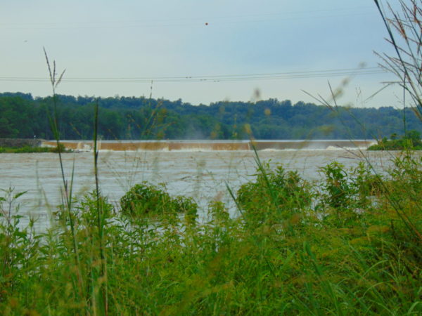
Downriver at Conewago Falls, ice jams behind the York Haven Dam and at several choke points within the riverine archipelago that extends from Haldeman Island to Haldeman Riffles in Lancaster County would be relieved as the river crested there during the afternoon of January 21st. The following photograph accurately relates the scene, minus the stench of mammalian feces and petroleum emanating from the polluted water of course.
Our friends (L to R) Rick Morton, Bob Zeager, Dan Seitz and his daughter Sierra witness the ice-choked Susquehanna River cresting below Conewago Falls on January 21, 1996. Bob awoke the previous morning inside his mobile home (left rear) to discover he was rapidly being surrounded by fast-rising water. With the ice-covered road now submerged in over three feet of river, he had no hope of getting out with his van, so he started removing clothing and a few other essentials by canoe. Dan soon arrived to move a few of his things to higher ground and de-energize both properties. We did our best to lend a hand, then we all got out of the floodplain. A short time after we had departed, Rick arrived and became concerned when he saw Bob’s van, now in almost four feet of water alongside his home. Rick parked his conveyance, also a van, on a rise in the lowland terrain, then made his way back the old Pennsylvania Canal towpath to make sure Bob wasn’t stranded. After concluding that he had already evacuated, Rick returned via the towpath to his van. He then discovered that yet another surge of quickly rising water had inundated the ice-covered section of access road by which he had arrived, so he was forced to wade out, leaving his vehicle behind. A short time later, he reached us by telephone proclaiming, “I’m out!”, and filled us in on the details. As the flood receded, Rick was able to retrieve his van on January 22nd. Bob’s van was totally destroyed and both his and Dan’s mobile homes were left uninhabitable. Though by no means their first experience with river flooding, this event proved particularly costly and stressful for Bob and Dan…the effects life-altering. The moral of the story: floodplains are for flooding, not filling, not building, and certainly not dwelling. Floodplains happen to make outstanding wildlife preserves, and that’s what this water-purifying alluvial terrace wetland is today. (Vintage 35 mm image)
Soon after their arrival during the late 1600s, the earliest trans-Atlantic human migrants to settle the Lower Susquehanna River Watershed began the process of eliminating many of our largest native fish species. They started by extirpating nature’s steward of lowland streams and wetlands, the North American Beaver. The beaver’s meticulously maintained dams and fisheries-friendly pools were promptly replaced by man-made impoundments designed to permanently divert water for powering lumber and grain mills. Behind these structures, silt deposits accumulated as the forests were clear cut and the land subjected to highly erosive farming methods. Mill dams would eventually be located on nearly every mile of suitable low-gradient stream in the basin. Populations of native coldwater fishes including Brook Trout were quickly lost or left isolated in scattered headwaters.
With their navigation of creeks blocked by nearly impenetrable mill dams, seasonally migratory freshwater and anadromous fish were denied access to their traditional spawning waters. The latter then had their populations seriously depleted, and in some cases extirpated, following construction of hydroelectric dams on the lower Susquehanna during the first half of the twentieth century. The loss these latter species, including the herrings, Striped Bass, and sturgeons, all of which attain great size only because of their ability to make a sea run to access the year-round food energy available in the Atlantic, constitute a tremendous reduction in the numbers, variety, and mass of fish occurring in the river and its tributaries.
Add to these events the various sources of pollution entering the lower Susquehanna’s waterways during the intervening years including acid mine drainage, agricultural nutrients and sediments, stormwater runoff, untreated domestic and industrial sewage, illegal dumping, pesticides, etc., and one can easily understand how the watershed’s native fishery was lost as a commercial, food, and recreational resource.
Presently, the effort to restore populations of self-sustaining anadromous fishes to the lower Susquehanna is stalled due to the presence of introduced invasive species, particularly Northern Snakeheads, in the river’s waters below Conowingo Dam. Lifts that carry migrating fishes over the lower river’s hydroelectric dams during the spring run are shut down to avoid extending the range of the hoards of non-native snakeheads to waters upstream of their present location. Any translocation of anadromous fish must now be completed by manually separating desired species from among the invaders and loading them into a tank truck for transport to waters upstream of the dams. But Northern Snakeheads are currently so prevalent at Conowingo that they are overwhelming the lift used for collecting and sorting fish as well.
Any slight hope that had existed for a return of harvestable stocks of American Shad or other sea-run native species to the Susquehanna and its tributaries seems to be fading. And widespread improvements to water quality that would promote reestablishment of sustained populations of native coldwater fishes like Brook Trout are strictly a long-range goal.
Recreational anglers, however, still remain in the game—but their reward is a bit of a booby prize. To compensate fisherman for the loss of their quarry on the river and in streams, and to promote an interest in the fishing pastime and conserving waterways, the stocking of various species of “game fish” has been a continuous undertaking, particular since the middle decades of the twentieth century. Some of these introductions are planned, others, like the release of Northern Snakeheads, are unsanctioned and outright illegal. The one thing most introductions have in common is that they consist of hardy, aggressive, predatory fishes that are non-native species (or native transplants from watersheds such as the Mississippi). Their presence, especially in large concentrations and particularly during the time immediately following introduction, can have a deleterious impact on native stream inhabitants. Some introduced fish, the Flathead Catfish for example, are upon discovery deemed invasive species; others, like the Smallmouth Bass, escape such a label not because they lack negative impacts on stream communities and ecosystems, but because they have been present for extended periods of time and have thus been accepted as part of the local fishing culture.
Hatchery-raised Rainbow Trout stocked by the hundreds in a lower Susquehanna valley creek for angling. The Rainbow Trout is native to the streams and rivers of the Pacific coast of North America. An anadromous form is known as the “Steelhead”. These sea-run trout with access to marine food sources during their growth years attain more than twice the size of freshwater forms and acquire oversized hooked jaws before ascending waterways to spawn.
The creation of recreational fisheries comprised of introduced species has certainly helped maintain an interest in the fishing hobby and in the conservation of waterways. It has even been a driving force for spectacular restorations of streams that otherwise would have languished in an impaired condition with little in the way of diversity of species—native or non-native. As anglers, we are especially indebted to those who’ve devoted their time, energies, and, in some cases, a lot of money to projects that specifically seek to reestablish native waterways within the challenging landscape of the Lower Susquehanna River Watershed. With an eye on the future, perhaps now is a good time to join them and focus our passion for freshwater angling on steering fisheries management more toward the native ecosystems approach—quality instead of quantity.
In that spirit, here are three items we can add to our tackle boxes this season to be better fisheries conservationists, instead of our own worst enemies.
Lead-free Weights- Replace the lead in your tackle box with tungsten or other lead-free alternatives to eliminate the potential impact this poisonous metal can have on you and wildlife like waterfowl and Bald Eagles. Make a special effort to rid your inventory of small pieces of shot that can easily be ingested by animals as they feed. Realistic Lures- Add sport to your fishing by using artificial lures. Today’s selections include very realistic versions of native fishes, crayfish, frogs, and other aquatic creatures. Use these life-like imitations and you won’t need to harvest native minnows and other wildlife from populations that are already being subjected to negative impacts from stocked legions of predatory “game fish”. You’ll also eliminate the risk of introducing non-native bait species into your favorite fishing waters!Trash Bag- Always bring a trash bag and carry out your litter. Be especially vigilant about monofilament fishing line.Fishermen are their own worst enemies, so you’ll need to pick up after the other guy too. Show the landowners and land managers who are our hosts a little consideration.
Best of luck this fishing season. We hope your time outdoors will motivate you to get involved with efforts to keep your local waterways clean. You might even be inspired to assist with projects that are planned or currently underway in the Lower Susquehanna River Watershed to restore stream segments, wetlands, and floodplains. Many of these projects are grassroots efforts and they’d love to have your participation. Your local county conservation district can steer you towards an active restoration group near you. Give them a ring.
Hatchery-raised Rainbow Trout and a “Golden Rainbow Trout” stocked for anglers in a restored segment of a stream in Lebanon County, Pennsylvania. The “Golden Rainbow Trout”, also known as the “Banana Trout”, is a Rainbow Trout color variant developed through multi-generational selective breeding of offspring produced by crossing a typical male with a yellow-mottled female mutant discovered in a hatchery in West Virginia in 1955. Today, “Golden Rainbow Trout” breed true, golden males crossed with golden females yielding golden young. The less colorful “Palomino Rainbow Trout” is produced by crossing a “Golden Rainbow Trout” with a typical Rainbow Trout.
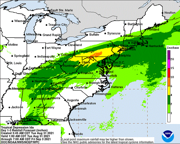
The deluge of rain that soaked the lower Susquehanna watershed during last week is now just a memory. Streams to the west of the river, where the flooding courtesy of the remnants of Hurricane Debby was most severe, have reached their crest and receded. Sliding away toward the Chesapeake and Atlantic is all that runoff, laden with a brew of pollutants including but not limited to: agricultural nutrients, sediment, petroleum products, sewage, lawn chemicals, tires, dog poop, and all that litter—paper, plastics, glass, Styrofoam, and more. For aquatic organisms including our freshwater fish, these floods, particularly when they occur in summer, can compound the effects of the numerous stressors that already limit their ability to live, thrive, and reproduce.
(Environmental Protection Agency image)
One of those preexisting stressors, high water temperature, can be either intensified or relieved by summertime precipitation. Runoff from forested or other densely vegetated ground normally has little impact on stream temperature. But segments of waterways receiving significant volumes of runoff from areas of sun-exposed impervious ground will usually see increases during at least the early stages of a rain event. Fortunately, projects implemented to address the negative impacts of stormwater flow and stream impairment can often have the additional benefit of helping to attenuate sudden rises in stream temperature.
While a row of trees along a creek can help provide protection from the thermal impact of the sun, a vegetative riparian buffer must be much wider to be effective for absorbing, cooling, and treating runoff from fields, lawns, and paved surfaces. This buffer is too narrow to prevent surface runoff from polluting the water.
Of the fishes inhabiting the Lower Susquehanna River Watershed’s temperate streams, the least tolerant of summer warming are the trouts and sculpins—species often described as “coldwater fishes”. Coldwater fishes require water temperatures below 70° Fahrenheit to thrive and reproduce. The optimal temperature range is 50° to 65° F. In the lower Susquehanna valley, few streams are able to sustain trouts and sculpins through the summer months—largely due to the effects of warm stormwater runoff and other forms of impairment.
Sculpins, including the Blue Ridge Sculpin (Cottus caeruleomentum) seen here, are native coldwater fishes which, during the 11,000 years since the last glacial maximum, have had the availability of their favored habitat sharply reduced by warming water temperatures and a rising Atlantic. During this interval, seawater has inundated the path of the “Late” Pleistocene lower Susquehanna which passed through the section of flooded river watershed we now call Chesapeake Bay and continued across the continental shelf to what was, during the glacial maximum, the river’s mouth at Norfolk Canyon. Today, cut off from neighboring drainage basins, sculpins survive exclusively in cold headwaters, and only in those where human alterations including pollution, dams, channelization, and reduced base flow haven’t yet eliminated their isolated populations. Formerly believed to be composed of two widespread North American species, the Slimy Sculpin (Cottus cognatus) and the Mottled Sculpin (Cottus bairdii), study in recent decades is discovering that sculpin populations in the present-day lower Susquehanna and neighboring Potomac headwaters consist of at least three newly delineated species: Blue Ridge Sculpin, Potomac Sculpin (Cottus gerardi), and Checkered Sculpin (Cottus sp.), the latter an as yet undescribed species found only in the refugium of limestone springs in the Potomac drainage in West Virginia; Frederick and Washington Counties, Maryland; and Franklin County, Pennsylvania. (United States Geological Survey image)Stare at this for a little while, you’ll figure it out…………More than 11,000 years ago, during the end of the last glacial period, when sea level was about 275 feet lower than it is today, there was no Chesapeake Bay, just a great Susquehanna River that flowed to the edge of the continental shelf and its mouth at Norfolk Canyon. It was a river draining taiga forests of pine, spruce , and fir, and it carried along the waters of all the present-day bay’s tributaries and more. The section of the river’s watershed we presently call the lower Susquehanna was, at the time, the upper Susquehanna watershed. Brook Trout and sculpins had the run of the river and its tributaries back then. And the entire watershed was a coldwater fishery, with limestone and other groundwater springs providing not refuge from summer heat, but a place to escape freezing water. (United States Geological Survey base image)Norfolk Canyon, the mouth of the Susquehanna River during the most recent glacial maximum, now lies more than 275 feet below the surface of the ocean and plunges to more than a mile in depth along the finger of out wash from the gorge. (United States Geological Survey image)Tens of thousands of trout are raised in state-operated and cooperative nurseries for stocking throughout the lower Susquehanna valley. These rearing facilities are located on spring-fed headwaters with sufficient flow to assure cold temperatures year round. While the Rainbow Trout and Brown Trout (Salmo trutta) are the most commonly stocked species, the Brook Trout (Salvelinus fontinalis) is the only one native to American waters. It is the least tolerant of stream warming and still reproduces in the wild only in a few pristine headwaters streams in the region. During spring, all three of these species have been observed on rare occasions entering the fish lift facilities at the hydroelectric dams on the river, presumably returning to the Susquehanna as sea-run trout.
Coldwater fishes are generally found in small spring-fed creeks and headwaters runs. Where stream gradient, substrate, dissolved oxygen, and other parameters are favorable, some species may be tolerant of water warmer than the optimal values. In other words, these temperature classifications are not set in stone and nobody ever explained ichthyology to a fish, so there are exceptions. The Brown Trout for example is sometimes listed as a “coldwater transition fish”, able to survive and reproduce in waters where stream quality is exceptionally good but the temperature may periodically reach the mid-seventies.
The Eastern Blacknose Dace is sometimes classified as a “coldwater transition fish”. It can be found in headwaters runs as well as in creeks with good water quality.The Longnose Dace is another “coldwater transition fish” known only from clear, clean, flowing waters.
More tolerant of summer heat than the trouts, sculpins, and daces are the “coolwater fishes”—species able to feed, grow, and reproduce in streams with a temperature of less than 80° F, but higher than 60° F. Coolwater fishes thrive in creeks and rivers that hover in the 65° to 70° F range during summer.
The Creek Chub is a familiar species of “coolwater fish” seldom found remaining in waters exceeding 80 degrees Fahrenheit.The Yellow Perch (Perca flavescens) was perhaps the most frequently targeted coolwater “gamefish” in the Lower Susquehanna River Watershed prior to the introduction of the Northern Pike (Esox lucius) and Muskellunge (Esox masquinongy). Today’s prevalence of warmwater streams and the dozens of species of non-native predatory fishes now naturalized within them have left the Yellow Perch populations greatly reduced and all but forgotten by anglers. Out of sight, out of mind. (National Park Service image)
What are the causes of modern-day reductions in coldwater and coolwater fish habitats in the lower Susquehanna River and its hundreds of miles of tributaries? To answer that, let’s take a look at the atmospheric, cosmic, and hydrologic processes that impact water temperature. Technically, these processes could be measured as heat flux—the rate of heat energy transfer per unit area per unit time, frequently expressed as watts per meter squared (W/m²). Without getting too technical, we’ll just take a look at the practical impact these processes have on stream temperatures.
HEAT FLUX PROCESSES IN A SEGMENT OF STREAM
Heat Flux Processes on Stream and River Segments. These processes could be measured as heat flux—the rate of heat energy transfer per unit area per unit time. (Environmental Protection Agency image)
INCOMING TEMPERATURE AND FLOW—The baseline temperature of stream water entering a given segment of waterway is obviously the chief factor determining its temperature when exiting that segment. Incoming temperature and flow also determine the water’s susceptibility to heat absorption or loss while transiting the segment. Lower flows may subject the given volume of water to a greater loss or gain of heat energy during the time needed to pass through the segment than the same volume at a higher flow. Lower flows may also reduce stream velocity and extend a given volume of water’s exposure time to the exchange of heat energy while moving through the segment. Generally speaking…
…the higher the stream flow, the less a given volume of that stream’s water may be impacted by the effects of the heat flux processes within the segment.
…the lower the stream flow, the more a given volume of that stream’s water may be impacted by the effects of the heat flux processes within that segment.
…the temperature and flow rate of precipitation entering the segment are factors that determine the impact of its heat energy transfer to or from a given volume of the stream’s waters.
…the temperature and flow rate of runoff and point-source discharges entering the segment are factors that determine the impact of their heat energy transfer to or from a given volume of the stream’s waters.
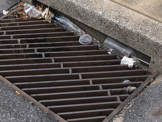
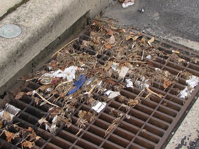
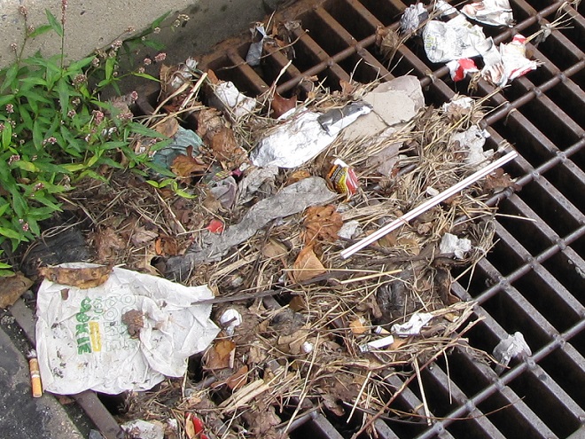
Stormwater from impervious surfaces including roads, parking lots, roofs, and lawns quickly impacts temperatures in small creeks. Channelized streams are availed few of the positive attributes provided by many of the heat flux processes we’re about to see. They therefore suffer from severe impairment and are exposed to temperature extremes that few aquatic organisms can survive. Runoff from sun-heated pavement during a summer thunderstorm can often exceed 100 degrees Fahrenheit and can, at sufficient flow rate, quickly raise the temperature of a small stream to well over 90 degrees.Stormwater runoff not only poses a thermal threat to waterways, its a significant source of a wide variety of pollutants.
GROUNDWATER INPUT—In streams connected to the aquifer, the temperature in a flowing segment can be impacted by the influx of cold groundwater. With temperatures ranging from about 52° to 60° Fahrenheit, groundwater will absorb heat from the stream in summer, and warm it in the winter. In warmwater streams, coldwater and coolwater fishes will often seek areas of the substrate where groundwater is entering for use as refugium from the summer heat. Yellow Perch in the lower Susquehanna are known to exhibit this behavior.
Creeks and rivers connected to the aquifer and receiving supplemental flow from it are known as “gaining streams”. These streams frequently feed water into the aquifer as well. (United States Geological Survey image)When flowing through an area experiencing drought or an excessive removal of groundwater (lots of wells, etc.), a waterway can become a “losing stream”, one that surrenders a portion of its flow to recharge the aquifer. Further downstream, the reduced flow can make such a creek or river more susceptible to the effects of heat flux processes. (United States Geological Survey image)Seriously depleted aquifers can lead to a “disconnected stream”. Smaller waterways subjected to these conditions will sometimes lose all their flow to the ground, often causing a catastrophic failure of the aquatic ecosystem supported therein. (United States Geological Survey image)Urban runoff overwhelms this small stream with polluted water than can reach temperatures of 100 degrees or more (left), then lets it high and dry with no baseflow during periods of dry weather (right) as the waterway becomes disconnected from the much-depleted aquifer.Well-designed and properly constructed stormwater retention basins not only recharge groundwater supplies for wells and streams, they can also help prevent thermal pollution in waterways. Planted with native wetland species and allowed to thrive, they can become treasured wildlife islands in otherwise inhospitable environs. The benefits don’t stop there; plants also help sequester nutrients contained in the runoff.
HYPORHEIC EXCHANGE—Related to groundwater input, hyporheic exchange is the slow movement of water through the rock, sand, gravel, and soils composing the streambed, saturated shoreline, shallow aquifer, and connected floodplain of a creek or river. As a heat flux process, hyporheic exchange helps moderate extremes in seasonal water temperatures by conducting energy between the solid materials in the zone and the flowing water. Hyporheic zones are important habitats for many species of aquatic invertebrates and spawning fish. Natural chemical processes within these zones convert ammonia-producing wastes into nitrite, then nitrate, allowing it to be absorbed as food by plants growing in the stream or in the alluvium within the zone. Vegetation removal, channelization, legacy sediments, silt deposits, and man-made walls and dams can negate the benefits of hyporheic exchange.
Exchange of surface and ground water within the hyporheic zone is most directly associated with high-gradient (left) and meandering (right) segments of streams. (United States Geological Survey image)Very common on streams in the lower Susquehanna valley are these accumulations of legacy sediments at the sites of former mill ponds. After the dams were removed, the creeks began eroding their way down through the mire as they tried to reestablish their floodplains and find their native substrate. These trapped waterways are not only cut off from their hyporheic zones, they’re now a major source of nutrient and sediment pollution. Misguided landowners like this one frequently dump fill into these sites to “save their land” and “control flooding”. The fill and materials added to “shore up the banks” do nothing to fix what ails the creek, but instead displace more water to make the impact of flooding even more widespread.Rehabilitation projects that remove legacy sediments help restore hyporheic exchange by reconnecting the stream to its underlying geology, its floodplain, and its wetlands. Rising waters remain in the floodplain where they get a good bio-scrubbing and help replenish the creek and groundwater supply. As the experts say, “floodplains are for flooding.”
ATMOSPHERIC EXCHANGE (CONVECTION, EVAPORATION)—Primarily a process by which a stream loses heat energy and cools its waters, atmospheric exchange is also a means by which a warm air mass can relinquish heat to cooler waters and thus increase their temperature. This phenomenon can be dramatically enhanced when a stream passes through a so-called urban heat island where air temperatures remain warm through the night. Convection, the movement of heat energy through a fluid (liquid or gas), causes warmer, less-dense water to rise to the surface of a stream, particularly where there is minimal turbulence. When the air above is cooler than the water’s surface layer, the stream will conduct heat energy across the water/atmosphere interface causing the warmed air molecules to rise in a convection column. If the atmospheric relative humidity is less than 100%, some surface water will vaporize—a process that expends more of the stream’s heat energy. The rate of convective and evaporative cooling in a given stream segment is directly related to the degree of difference between the water temperature and air temperature, and to the relative humidity in the air mass above the lake, creek, or river. The mechanical action of stream turbulence including rapids, riffles, and falls increases the contact area between air and water to maximize the atmospheric exchange of heat energy. The convective air current we call surface wind has a turbulent wave-producing effect on water that can also maximize atmospheric exchange; think of a cold autumn wind robbing heat energy from a warm lake or river or a hot summer wind imparting its heat to a cooler creek. These exchanges are both conductive in nature (air-to-water/water-to-air) and evaporative, the latter being expedited by the movement of dry air over warm water.
Usually classified as one of the coolwater fishes, the bottom-dwelling Tessellated Darter can thrive in the warmer creeks and in the main stem of the Susquehanna by inhabiting riffles where atmospheric exchange in the form of increased evaporation helps reduce temperatures and convective currents carry the cooler, well-oxygenated water to the streambed.Humans utilize the concept of atmospheric exchange, adopting the phenomena of evaporation and convection to cool the hot waters produced during electric generation and other industrial processes before discharge into a lake or river.
STREAMBED CONDUCTIVE EXCHANGE—In the lower Susquehanna watershed, there may be no better natural example of streambed conductive exchange than the Triassic-Jurassic diabase pothole bedrocks of Conewago Falls on the river at the south end of Three Mile Island.
During sunny days, the massive diabase pothole rocks at Conewago Falls absorb solar (shortwave) radiation, then conduct that heat energy into the flowing water, often continuing to pass the accumulated warmth into the river during the night. On cloudy days, the riverbed collects longwave atmospheric radiation, a heat flux process that yields significantly less energy for conduction into the rapids, riffles, and pools of the falls. During periods of low river flow, the heating effect of streambed conductive exchange can become magnified. Compared to conditions that prevail when torrents of turbid water are rushing through the falls, partially exposed bedrock surrounded by clear water collects radiated energy much more efficiently, then conducts the heat to a greatly reduced volume of passing water. During summer and autumn, this process can create a mix of temperature zones within the falls with warmer water lingering in slow-moving pools and cooler water flowing in the deeper fast-moving channels. Along the falls’ mile-long course, a haven is created for aquatic organisms including warmwater and some coolwater fishes, oft times attracting anglers and a variety of hungry migrating birds as well.Classified as one of our coolwater fishes, the Fallfish finds favorable conditions for feeding, growing, and spawning in the well-oxygenated waters of Conewago Falls.Though the lower Susquehanna River is classified as a warmwater fishery, the Northern Hog Sucker (Hypentelium nigricans), another of our native coolwater fishes, finds the fast-moving waters of Conewago Falls to its liking. Northern Hog Suckers are known to inhabit streams cold enough to host trout. They exhibit remarkable home range fidelity, sometimes spending their entire lives occupying the same several hundred feet of waterway. Northern Hog Suckers are often designated an indicator of good water quality, intolerant of many stream impairment parameters. Their presence in Conewago Falls provides testament to the quality of the warmwater fishery there.An unnatural example. The reduced base flow in this channelized and severely impaired creek has been rendered vulnerable to the negative impacts of several heat flux processes including streambed conductive exchange. Urban stormwater/surfacewater inflow, solar (shortwave) radiation, and heat conducted into the stream from the masonry walls, curbs, and raceway can all conspire to cook aquatic organisms with life-quenching summer water temperatures exceeding 90 degrees Fahrenheit.
SOLAR (SHORTWAVE) RADIATION—The sun provides the energy that fuels the earth’s complex climate. The primary heat flux process that heats our planet is the absorption of solar radiation in the shortwave spectrum, which includes ultraviolet, visible, and infrared frequencies at the upper end of the longwave spectrum. Streams and other bodies of water absorb the greatest amounts of solar (shortwave) radiation during the weeks around summer solstice when the sun at mid-day is closer to zenith than at any other time of the year. However, the heating impact of the radiation may be greatest when the volume of water in the creek, river, or lake is at its minimum for the year—often during early fall.
The rate, measured in watts per square meter, at which solar (shortwave) energy is directly radiated to a given area on the earth’s surface (including streams and other waters) is determined by: solar activity, the angle of the sun in the sky, aspect (slope) of the receiving surface, the opacity of the overlying atmosphere, and the distance of the earth from the sun. The former varies with the year’s seasons, the time of day, and the latitude of a given area. The latter is currently at its annual minimum when earth is at perihelion during the early days of January, thus providing the northern hemisphere with a little bump in radiation during the shortest days of the year when the sun is at its lowest angle in the sky. (NASA image)A varying portion of the solar (shortwave) radiation reaching the earth is reflected back into space by clouds. A smaller share is absorbed by the atmosphere, thus heating it. An even lesser quantity is reflected back into space by water and land. The remainder of the energy is absorbed by the planet’s surfaces, its water and land. (NASA image)
INCIDENT SHORTWAVE RADIATION—Also known as insolation (incoming solar radiation), incident shortwave radiation is the sum total energy of both the direct solar radiation that travels to the earth’s surface unaffected by the atmosphere and the diffuse radiation, waves that have been weakened and scattered by constituents of the atmosphere before reaching the planet’s surface. On a cloudy day, the warming of terrestrial surfaces including streams and other bodies of water is the result of diffuse radiation. On days with any amount of sunshine at all, both direct and diffuse radiation heat our waters and lands.
Warmwater fishes such as the native Pumpkinseed (Lepomis gibbosus) thrive in sun-drenched 70-to-85-degree waters as long as other heat flux processes prevent sudden temperature increases and oxygen depletion.Mowed stream banks offer a waterway no protection from incoming solar (shortwave) radiation, nor terrestrial forms of impairment including nutrient-rich stormwater runoff and silt.
REFLECTED SHORTWAVE RADIATION—known as albedo, reflected solar (shortwave) radiation is energy directed away from the earth’s surface before being absorbed. A surface’s albedo value is basically determined by its color, black having little reflective value, white and silvery surfaces reflecting nearly all solar (shortwave) radiation away. A surface with no reflective properties has an albedo value of 0, while a totally reflective surface has a value of 1. Clean snow with a value of about 0.85 to 0.9 (85% to 90%) is a highly reflective surface; yellow snow isn’t as good. A stream, river, or lake blanketed with ice and snow will absorb very little solar energy and will rely upon other heat flux processes to trigger a melt and thaw. The surface of open water has a varying albedo value determined mostly by the angle of the sun. Solar radiation striking the water’s surface at a low angle is mostly reflected away, while that originating at an angle closer to zenith is more readily absorbed.
To avoid the heating effects of solar (shortwave) and atmospheric longwave radiation, coldwater and coolwater fishes require streams offering protection from full exposure to direct sunlight and cloud cover. Runs and creeks flowing beneath a closed canopy of forest trees are shielded from 25% or more of incoming radiation and are thus able to better maintain thermal stability during the most vulnerable period of the year for temperature-sensitive fishes, May through October.
LONGWAVE RADIATION—Radiation in the longwave spectrum is composed of infrared waves at frequencies lower than those of the shortwave spectrum. Longwave radiation, sometimes just called infrared radiation, is produced by the earth and its atmosphere and is propagated in all directions, day and night. It warms mostly the lower atmosphere which in turn warms the earth’s surface including its waters. Some longwave energy can even be radiated into the waterway from its own streambed—and the stream can return the favor. Other forms of mass surrounding a stream such as a rocky shoreline or a man-made structure such as bridge pier can trade longwave radiation with a waterway. The effect of these latter exchanges is largely trivial and never rivals the heat flux transfer of warm to cold provided by conduction.
Longwave radiation emissions slow as the temperature of the emitting mass decreases, just as they also increase with temperature of the mass. Longwave radiation emissions therefore decrease with altitude along with the temperature of the water vapor, carbon dioxide, methane, and other gases that produce them. As such, the highest reaches of the atmosphere have a greatly reduced capability of shedding longwave radiation into space. At ground level, lakes, creeks, and streams receive their greatest dose of longwave radiation while beneath the cover of low-lying clouds or fog. (NASA image)
CANOPY RADIATION—Trees emit longwave radiation that may have a limited heat flux impact on waterway temperature. This radiation is diffuse, of scattered effect, and scarcely detectable, particularly beneath multilayered dense canopies. Some of the infrared energy transmitted by the tree canopy is radiated skyward as well.
WATER RADIATION—Water, like all earthly matter composed of vibrating molecules, emits longwave radiation. This heat flux process provides an ongoing cooling effect to streams, rivers, lakes, and oceans—warmer ones shedding infrared energy at a faster rate than those that are cold.
Now that we have a basic understanding of the heat flux processes responsible for determining the water temperatures of our creeks and rivers, let’s venture a look at a few graphics from gauge stations on some of the lower Susquehanna’s tributaries equipped with appropriate United States Geological Survey monitoring devices. While the data from each of these stations is clearly noted to be provisional, it can still be used to generate comparative graphics showing basic trends in easy-to-monitor parameters like temperature and stream flow.
Each image is self-labeled and plots stream temperature in degrees Fahrenheit (bold blue) and stream discharge in cubic feet per second (thin blue).
The West Conewago Creek drains much of the Gettysburg Basin’s Triassic redbeds in Adams and northern York Counties in Pennsylvania and includes a small headwaters area in northern Maryland. The gauge station is located just a over a mile upstream from the waterway’s mouth on the Susquehanna just below Conewago Falls. Right through the summer heatwave, this 90-day graph shows a consistent daily pattern of daytime rises in temperature and nighttime cooling. To the right, a rapid cool down can be seen coinciding with two periods of high water, the first from a series of heavy thundershowers, the second from flooding caused by the remnants of Hurricane Debby. Notice that the early August downpours were so heavy that they cooled the hot surface runoff and waterway quickly, without creating a rise in stream temperature at the gauging station. Had this monitoring device been located on a small tributary in an area with an abundance of impervious surfaces, there would probably have been a brief rise in stream temperature prior to the cooldown. (United States Geological Survey image)
The daily oscillations in temperature reflect the influence of several heat flux processes. During the day, solar (shortwave) radiation and convection from summer air, especially those hot south winds, are largely responsible for the daily rises of about 5° F. Longwave radiation has a round-the-clock influence—adding heat to the stream during the day and mostly shedding it at night. Atmospheric exchange including evaporative cooling may help moderate the rise in stream temperatures during the day, and certainly plays a role in bringing them back down after sunset. Along its course this summer, the West Conewago Creek absorbed enough heat to render it a warmwater fishery in the area of the gauging station. The West Conewago is a shallow, low gradient stream over almost its entire course. Its waters move very slowly, thus extending their exposure time to radiated heat flux and reducing the benefit of cooling by atmospheric exchange. Fortunately for bass, catfish, and sunfish, these temperatures are in the ideal range for warmwater fishes to feed, grow, and reproduce—generally over 80° F, and ideally in the 70° to 85° F range. Coolwater fishes though, would not find this stream segment favorable. It was consistently above the 80° F maximum and the 60° to 70° F range preferred by these species. And coldwater fishes, well, they wouldn’t be caught dead in this stream segment. Wait, scratch that—the only way they would be caught in this segment is dead. No trouts or sculpins here.
The Codorus Creek drains primarily the carbonate valleys of York County to the south of the West Conewago watershed. This gauge station is located about a mile upstream from the creek’s mouth on the Susquehanna just below Haldeman Riffles. The graphic pattern is very similar to that of the West Conewago’s: daily heating and cooling cycles and a noticeable drop in stream temperature in early August caused by a day of thundershowers followed by the remnants of Hurricane Debby. (United States Geological Survey image)
Look closely and you’ll notice that although the temperature pattern on this chart closely resembles that of the West Conewago’s, the readings average about 5 degrees cooler. This may seem surprising when one realizes that the Codorus follows a channelized path through the heart of York City and its urbanized suburbs—a heat island of significance to a stream this size. Before that it passes through numerous impoundments where its waters are exposed to the full energy of the sun. The tempering factor for the Codorus is its baseflow. Despite draining a smaller watershed than its neighbor to the north, the Codorus’s baseflow (low flow between periods of rain) was 96 cubic feet per second on August 5th, nearly twice that of the West Conewago (51.1 cubic feet per second on August 5th). Thus, the incoming heat energy was distributed over a greater mass in the Codorus and had a reduced impact on its temperature. Though the Codorus is certainly a warmwater fishery in its lower reaches, coolwater and transitional fishes could probably inhabit its tributaries in segments located closer to groundwater sources without stress. Several streams in its upper reaches are in fact classified as trout-stocked fisheries.
This is a zoomed-in look at the previous graph showing the impact of a rainfall event on the water temperatures in Codorus Creek. Unlike the sharp declines accompanying the deluge of flood waters during the two events in early August, these lesser storms in late June generated just enough runoff to capture heat energy from impervious surfaces and warm the creek, temporarily breaking the daily heating/cooling cycle. Upstream in the immediate area of the runoff, the impact on the stream and/or its tributaries was probably much more dramatic, certainly raising temperatures into the nineties or above. (United States Geological Survey image)Kreutz Creek drains a carbonate bedrock area of York County and flows parallel to the Lincoln Highway (US 30) to enter the Susquehanna at Wrightsville. The gauging station is about one mile upstream from the creek’s mouth. (United States Geological Survey image)
The Kreutz Creek gauge shows temperature patterns similar to those in the West Conewago and Codorus data sets, but notice the lower overall temperature trend and the flow. Kreutz Creek is a much smaller stream than the other two, with a flow averaging less than one tenth that of the West Conewago and about one twentieth of that in the Codorus. And most of the watershed is cropland or urban/suburban space. Yet, the stream remains below 80° F through most of the summer. The saving graces in Kreutz Creek are reduced exposure time and gradient. The waters of Kreutz Creek tumble their way through a small watershed to enter the Susquehanna within twenty-four hours, barely time to go through a single daily heating and cooling cycle. As a result, their is no chance for water to accumulate radiant and convective heat over multiple summer days. The daily oscillations in temperature are less amplified than we find in the previous streams—a swing of about three degrees compared to five. This indicates a better balance between heat flux processes that raise temperature and those that reduce it. Atmospheric exchange in the stream’s riffles, forest cover, and good hyporheic exchange along its course could all be tempering factors in Kreutz Creek. From a temperature perspective, Kreutz Creek provides suitable waters for coolwater fishes.
Muddy Creek drains portions of southern York County through rolling farmland and woodlots. There are no large impoundments or widespread urban impacts in the watershed, which may help explain its slightly lower temperature trends. (United States Geological Survey image)
Muddy Creek is a trout-stocked fishery, but it cannot sustain coldwater species through the summer heat. Though temperatures in Muddy Creek may be suitable for coolwater fishes, silt, nutrients, low dissolved oxygen, and other factors could easily render it strictly a warmwater fishery, inhabited by species tolerant of significant stream impairment.
Chiques Creek drains mostly limestone farmland in northwestern Lancaster County. The gauging station is located near the stream’s mouth on the Susquehanna at Chiques (Chickies) Rock. Oscillations in temperature again resemble the other waterways, but daily highs remain almost entirely below 80 degrees. (United States Geological Survey image)
A significant number of stream segments in the Chiques watershed have been rehabilitated to eliminate intrusion by grazing livestock, cropland runoff, and other sources of impairment. Through partnerships between a local group of watershed volunteers and landowners, one tributary, Donegal Creek, has seen riparian buffers, exclusion fencing, and other water quality and habitat improvements installed along nearly ever inch of its run from Donegal Springs through high-intensity farmland to its mouth on the main stem of the Chiques just above its confluence with the Susquehanna. The improved water quality parameters in the Donegal support native coldwater sculpins and an introduced population of reproducing Brown Trout. While coldwater habitat is limited to the Donegal, the main stem of the Chiques and its largest tributary, the Little Chiques Creek, both provide suitable temperatures for coolwater fishes.
Streams in the Chiques Creek and similar limestone watersheds often pass through areas with significant bedrock formations. Heat flux processes including groundwater input, hyporheic exchange, and streambed conductive exchange can have a greater influence on water temperature along these segments.A breeding condition Eastern Balcknose Dace, one of the coldwater transition fishes found in the Chiques and its tributaries.The Common Shiner (Luxilus cornutus), a fish tolerant of warmwater streams, prefers cool, clear waters for spawning. For protection from late-spring and summer heat, breeding males may seek a section of creek with a streambed inflow of limestone groundwater to defend as their nesting territory.A closeup of the Chiques Creek graph showing what appears to be a little bump in temperature caused by surface runoff during a couple of late-May showers. Stream rehabilitation is an ongoing process and the pressures of land disturbances both old and new present challenges to those who make it their passion to fix the wrongs that have been inflicted upon our local waters. Even the exemplary Donegal Creek faces new threats from urbanization in one of its headwater areas several miles to the northwest of the historic springs. (United States Geological Survey image)Conewago Creek (East) drains primarily Triassic redbed farmlands in Dauphin, Lancaster, and Lebanon Counties. Much of the headwaters area is forested but is experiencing an increasing rate of encroachment by housing and some commercial development. Conewago Creek (East) enters the Susquehanna on the east side of Conewago Falls at Three Mile Island. The watershed is equipped with three U.S.G.S. gauge stations capable of providing temperature data. This first one is located just over a mile upstream of the creek’s mouth. (United States Geological Survey image)
Despite its meander through and receipt of water from high-intensity farmland, the temperature of the lower Conewago (East) maxes out at about 85° F, making it ideal for warmwater fishes and even those species that are often considered coolwater transition fishes like introduced Smallmouth Bass, Rock Bass, Walleye, and native Margined Madtom. This survivable temperature is a testament to the naturally occurring and planted forest buffers along much of the stream’s course, particularly on its main stem. But the Conewago suffers serious baseflow problems compared to other streams we’ve looked at so far. Just prior to the early August storms, flow was well below 10 cubic feet per second for a drainage area of more than fifty square miles. While some of this reduced flow is the result of evaporation, much of it is anthropogenic in origin as the rate of groundwater removal continues to increase and a recent surge in stream withdraws for irrigation reaches its peak during the hottest days of summer.
A juvenile Rock Bass.A juvenile Margined Madtom.A closer look at the Conewago Creek (East) graphic shows the temperature drop associated with a series of thundershowers and the remnants of Hurricane Debby in early August. Despite the baseflow being below five cubic feet per second, the cooling effect of the downpours as measured in the area of the gauge was significant enough to overwhelm any heating of runoff that may have occurred as precipitation drained across hardened soils or man-made impervious surfaces. (United States Geological Survey image)
A little side note—the flow rate on the Conewago at the Falmouth gauge climbed to about 160 cubic feet per second as a result of the remnants of Hurricane Debby while the gauge on the West Conewago at Manchester skyrocketed to about 20,000 cubic feet per second. Although the West Conewago’s watershed (drainage area) is larger than that of the Conewago on the east shore, it’s larger only by a multiple of two or three, not 125. That’s a dramatic difference in rainfall!
The Bellaire monitoring station on Conewago Creek (East) is located on the stream’s main stem just downstream from the mouth of Little Conewago Creek, a tributary with its origins in farmland and woodlots. (United States Geological Survey image)
The temperatures at the Bellaire monitoring station, which is located upstream of the Conewago’s halfway point between its headwaters in Mount Gretna and its mouth, are quite comparable to those at the Falmouth gauge. Although a comparison between these two sets of data indicate a low net increase in heat absorption along the stream’s course between the two points, it also suggests sources of significant warming upstream in the areas between the Bellaire gauge and the headwaters.
Data from the gauge site on the Little Conewago Creek shows a temperature averaging about five degrees cooler than the gauge several miles downstream on the main stem of the Conewago at Bellaire. (United States Geological Survey image)
The waters of the Little Conewago are protected within planted riparian buffers and mature woodland along much of their course to the confluence with the Conewago’s main stem just upstream of Bellaire. This tributary certainly isn’t responsible for raising the temperature of the creek, but is instead probably helping to cool it with what little flow it has.
A stream like the Little Conewago Creek with daily temperatures that remain mostly below 80 degrees and retreat to 75 degrees or less during the night can be suitable for coldwater transition fishes like these juvenile Eastern Blacknose Dace (top) and Longnose Dace.
Though mostly passing through natural and planted forest buffers above its confluence with the Little Conewago, the main stem’s critically low baseflow makes it particularly susceptible to heat flux processes that raise stream temperatures in segments within the two or three large agricultural properties where owners have opted not to participate in partnerships to rehabilitate the waterway. The headwaters area, while largely within Pennsylvania State Game Lands, is interspersed with growing residential communities where potable water is sourced from hundreds of private and community wells—every one of them removing groundwater and contributing to the diminishing baseflow of the creek. Some of that water is discharged into the stream after treatment at the two municipal sewer plants in the upper Conewago. This effluent can become quite warm during processing and may have significant thermal impact when the stream is at a reduced rate of flow. A sizeable headwaters lake is seasonally flooded for recreation in Mount Gretna. Such lakes can function as effective mid-day collectors of solar (shortwave) radiation that both warms the water and expedites atmospheric exchange.
The Conewago Creek (East) Watershed from the Bellaire U.S.G.S. Gauging Station (lower left) upstream to the headwaters in Mount Gretna. (United States Geological Survey image)
Though Conewago Creek (East) is classified as a trout-stocked fishery in its upper reaches in Lebanon County, its low baseflow and susceptibility to warming render it inhospitable to these coldwater fishes by late-spring/early summer.
Despite being considered a warmwater fish, the River Chub (Nocomis micropogon) will ascend streams like the Conewago to seek cooler, gravel-bottomed waters for spawning. Reduced baseflow has probably rendered the stream currently too small for this species on Pennsylvania State Game Lands in Colebrook where this specimen was photographed in 2018.The Golden Shiner, another warmwater fish, often ascends streams to enter cooler water. Juvenile Golden Shiners like this one will move into shallower headwaters not only to seek reduced temperatures, but to escape large predatory fishes as well.Irrigation of agricultural fields using a large portion of the already diminished baseflow in the Conewago Creek (East) just downstream of the Bellaire gauging station. Despite millions of dollars in investment to rehabilitate this Susquehanna valley stream, the riparian buffers and other practices can have little effect when the creek gets sucked down to just a trickle. Low baseflow is a hard nut to crack. It’s best prevented, not corrected.Hammer Creek, a trout-stocked fishery, originates, in part, within Triassic conglomerate in the Furnace Hills of Lebanon County, then flows north into the limestone Lebanon Valley where it picks up significant flow from other tributaries before working its way south back through the Furnace Hills into the limestone farmlands of Lancaster County. From there the stream merges with the Cocalico Creek, then the Conestoga River, and at last the Susquehanna. Note the tremendous daily temperature oscillations on this headwaters stream as it surges about 15 degrees each day before recovering back close to groundwater temperature by sunrise the next day. (United States Geological Survey image)Headwaters of Hammer Creek including Buffalo Springs, a significant source of cold groundwater feeding the western leg of the stream. The large dams on this section that created the Lebanon and Rexmont Reservoirs have been removed. (United States Geological Survey base image)
The removal of two water supply dams on the headwaters of Hammer Creek at Rexmont eliminated a large source of temperature fluctuation on the waterway, but did little to address the stream’s exposure to radiant and convective heat flux processes as it meanders largely unprotected out of the forest cover of Pennsylvania State Game Lands and through high-intensity farmlands in the Lebanon Valley. Moderating the temperature to a large degree is the influx of karst water from Buffalo Springs, located about two miles upstream from this gauging station, and other limestone springs that feed tributaries which enter the Hammer from the east and north. Despite the cold water, the impact of the stream’s nearly total exposure to radiative and other warming heat flux processes can readily be seen in the graphic. Though still a coldwater fishery by temperature standards, it is rather obvious that rapid heating and other forms of impairment await these waters as they continue flowing through segments with few best management practices in place for mitigating pollutants. By the time Hammer Creek passes back through the Furnace Hills and Pennsylvania State Game Lands, it is leaning toward classification as a coolwater fishery with significant accumulations of sediment and nutrients. But this creek has a lot going for it—mainly, sources of cold water. A core group of enthusiastic landowners could begin implementing the best management practices and undertaking the necessary water quality improvement projects that could turn this stream around and make it a coldwater treasure. An organized effort is currently underway to do just that. Visit Trout Unlimited’s Don Fritchey Chapter and Donegal Chapter to learn more. Better yet, join them as a volunteer or cooperating landowner!
The male Creek Chub, one of our coolwater fishes, develops head tubercles and becomes flushed with color during spawning season. Hammer Creek not only provides a home for the Creek Chub, its cold headwaters provide refuge for a population of native Brook Trout too.Like no other example we’ve looked at so far, this closeup of the Hammer Creek graphic shows temperature bumps correlating with the stormwater runoff from early August’s rains. Because the stream flow is small and the precipitation rate was not as great at this location, the effect of heat flux from runoff is more readily apparent. (United States Geological Survey image)Brook Trout adult and juvenile. (United States Fish and Wildlife Service image by Ryan Hagerty)
For coldwater fishes, the thousands of years since the most recent glacial maximum have seen their range slowly contract from nearly the entirety of the once much larger Susquehanna watershed to the headwaters of only our most pristine streams. Through no fault of their own, they had the misfortune of bad timing—humans arrived and found coldwater streams and the groundwater that feeds them to their liking. Some of the later arrivals even built their houses right on top of the best-flowing springs. Today, populations of these fishes in the region we presently call the Lower Susquehanna River Watershed are seriously disconnected and the prospect for survival of these species here is not good. Stream rehabilitation, groundwater management, and better civil planning and land/water stewardship are the only way coldwater fishes, and very possibly coolwater fishes as well, will survive. For some streams like Hammer Creek, it’s not too late to make spectacular things happen. It mostly requires a cadre of citizens, local government, project specialists, and especially stakeholders to step up and be willing to remain focused upon project goals so that the many years of work required to turn a failing stream around can lead to success.
Riparian buffers with fences to exclude livestock can immediately begin improving water quality. With establishment of such vegetative buffers, the effects of stressors that otherwise eliminate coldwater and coolwater fishes from these segments will begin to diminish.Within five to ten years, a riparian buffer planted with native trees is not only helping to reduce nutrient and sediment loads in the stream, it is also shielding the waters from heat flux processes including the solar (shortwave) radiation that raises water temperatures to levels not tolerated by coldwater and coolwater fishes.A well-established riparian buffer.A forested stream.
You’re probably glad this look at heat flux processes in streams has at last come to an end. That’s good, because we’ve got a lot of work to do.
Add one more benefit to the wildflower meadow, it infiltrates stormwater to recharge the aquifer much better than mowed grass. And another related plus, it reduces runoff and its thermal pollution. Besides, you don’t have time to mow grass, because we have work to do!Our native coldwater fishes including the Potomac Sculpin will survive only if we protect and expand the scattered few habitats where they have taken refuge. They have no choice but to live in these seriously threatened places, but we do. So let’s give ’em some space. How ’bout it? (United States Fish and Wildlife Service image by Ryan Hagerty)
Tuesday’s collision of the container ship Dali into Baltimore’s Francis Scott Key Bridge and the nearly immediate collapse of the span into the chilly waters below reminds us just how unforgiving and deadly maritime accidents can be. Upon termination of rescue and recovery operations, salvage and cleanup will be prioritized as the next steps in the long-term process of reopening the navigable waters to ship traffic and construction of a new bridge. Part of the effort will include monitoring for leaks of fuels and other hazardous materials from the ship, its damaged cargo containers, and vehicles and equipment that were on the bridge when it failed.
Damage to the hull of the Dali and to the cargo containers on her deck could lead to leaks of hazardous liquids or other materials into Chesapeake Bay. (United States Army Corps of Engineers Baltimore image)
On the waters and shores of today’s Chesapeake, numerous county, state, and federal agencies, including the United States Coast Guard, monitor and inspect looking for conditions and situations that could lead to point-source or accidental discharges of petroleum products and other hazardous materials into the bay. Many are trained, equipped, and organized for emergency response to contain and mitigate spills upon detection. But this was not always the case.
Through much of the twentieth century, maritime spills of oil and other chemicals magnified the effects of routine discharges of hazardous materials and sanitary sewer effluent into the Chesapeake and its tributaries. The cumulative effect of these pollutants progressively impaired fisheries and bay ecosystems leading to noticeable declines in numbers of many aquatic species. Rather frequently, spills or discharges resulted in conspicuous fish and/or bird kills.
One of the worst spills occurred near the mouth of the Potomac River on February 2, 1976, when a barge carrying 250,000 gallons of number 6 oil sank in a storm and lost its cargo into the bay. During a month-long cleanup, the United States Coast Guard recovered approximately 167,000 gallons of the spilled oil, the remainder dispersed into the environment. A survey counted 8,469 “sea ducks” killed. Of the total number, the great majority were Horned Grebes (4,347 or 51.3%) and Long-tailed Ducks (2,959 or 34.9%). Other species included Surf Scoter (Melanitta perspicillata) (405 or 4.8%), Common Loon (195 or 2.3%), Bufflehead (166 or 2.0%), Ruddy Duck (107 or 1.3%), Common Goldeneye (78 or 0.9%), Tundra Swan (46 or 0.5%), Greater Scaup (19 or 0.2%), American Black Duck (12 or 0.2%), Common Merganser (11 or 0.1%), Canvasback (10 or 0.1%), Double-crested Cormorant (10 or 0.1%), Canada Goose (8 or 0.1%), White-winged Scoter (Melanitta deglandi) (7 or 0.1%), Redhead (5 or 0.1%), gull species (10 or 0.1%), miscellaneous ducks and herons (13 or 0.2%) and unidentified (61 or 0.7%). During the spring migration, a majority of these birds would have made their way north and passed through the lower Susquehanna valley. The accident certainly impacted the occurrence of the listed species during that spring in 1976, and possibly for a number of years after.
Of the 8,469 birds killed by the February 2, 1976, oil spill on the Chesapeake, 51.3% (4,347) were Horned Grebes. Many of them would have migrated north through the Lower Susquehanna River Watershed during the coming spring.
The Federal Water Pollution Control Act Amendments of 1972, commonly known as the Clean Water Act, put teeth into the original FWCPCA of 1948 and began reversing the accumulation of pollutants in the bay and other bodies of water around the nation. Additional amendments in 1977 and 1987 have strengthened protections and changed the culture of “dump-and-run” disposal and “dilution-is-the-solution” treatment of hazardous wastes. During the late nineteen-seventies and early nineteen-eighties, emergency response teams and agencies began organizing to control and mitigate spill events. The result has been a greater awareness and competency for handling accidental discharges of fuels and other chemicals into Chesapeake Bay and other waterways. These improvements can help minimize the environmental impact of the Dali’s collision with the Francis Scott Key Bridge in Baltimore.
Oil spills and other pollution in the Chesapeake can impact populations of migratory fish including the anadromous Hickory Shad which are presently transiting the bay on their way to the waters of the Susquehanna below Conowingo Dam.
SOURCES
Roland, John V., Moore, Glenn E., and Bellanca, Michael A. 1977. “The Chesapeake Bay Oil Spill—February 2, 1976: A Case History”. International Oil Spill Conference Proceedings (1977). 1977 (1): 523-527.
Your best bet for finding migrating shorebirds in the lower Susquehanna region is certainly a visit to a sandbar or mudflat in the river. The Conejohela Flats off Washington Boro just south of Columbia is a renowned location. Some man-made lakes including the one at Middle Creek Wildlife Management Area are purposely drawn down during the weeks of fall migration to provide exposed mud and silt for feeding and resting sandpipers and plovers. But with the Susquehanna running high due to recent rains and the cost of fuel trending high as well, maybe you want to stay closer to home to do your observing.
Fortunately for us, migratory shorebirds will drop in on almost any biologically active pool of shallow water and mud that they happen to find. This includes flooded portions of fields, construction sites, and especially stormwater retention basins. We stopped by a new basin just west of Hershey, Pennsylvania, and found more than two dozen shorebirds feeding and loafing there. We took each of these photographs from the sidewalk paralleling the south shore of the pool, thus never flushing or disturbing a single bird.
Designed to prevent stream flooding and pollution, this recently installed stormwater retention basin along US 322 west of Hershey, Pennsylvania, has already attracted a variety of migrating plovers and sandpipers.Killdeer stick close to exposed mud as they feed.Two of more than a dozen Least Sandpipers found busily feeding in the inch-deep water.A Lesser Yellowlegs searching for small invertebrates.Two Lesser Yellowlegs work out a disagreement.Male Twelve-spotted Skimmers patrol the airspace above a pair of Least Sandpipers. Dragonflies and other aquatic insects are quick to colonize the waters held in well-engineered retention basins. Proper construction and establishment of a functioning food chain/web in these man-made wetlands prevents them from becoming merely temporary cesspools for breeding mosquitos.
So don’t just drive by those big puddles, stop and have a look. You never know what you might find.
A Semipalmated Sandpiper (middle right) joins a flock of Least Sandpipers.Pectoral Sandpipers (two birds in the center) are regular fall migrants on the Susquehanna at this time of year. They are most frequently seen on gravel and sand bars adjacent to the river’s grassy islands, but unusually high water for this time of year prevents them from using this favored habitat. As a result, you might be lucky enough to discover Pectoral Sandpipers on almost any mudflat in the area.Two Pectoral Sandpipers and five smaller, but otherwise very similar, Least Sandpipers.A Killdeer (right), a Semipalmated Plover (upper right), and Least and Pectoral Sandpipers (left).
As your editor here at susquehannawildlife.net, I’d like to take a moment to thank all the volunteers who gave of their valuable time today to pick up litter, plant trees, and take other civic actions in observance of Earth Day. Your hard work has not gone unnoticed.
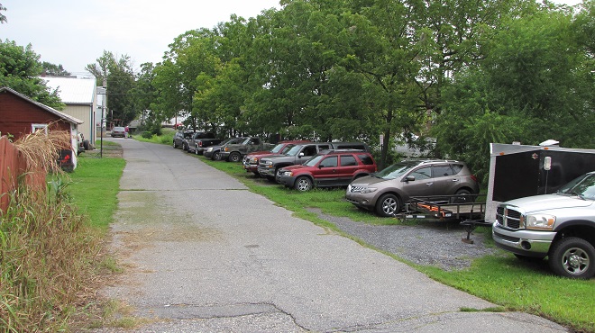
Special appreciation goes out to the anonymous crew that worked its way through the area surrounding our headquarters to pick up the trash on the rental and business properties in the neighborhood. My personal thanks is extended to you.
If you’ve never lived in an urban or downtown area, you’re probably unaware of the environmental damage and decline in the quality of life that occurs when “investors” start buying up the houses near you. The first things to go are the trees and shrubs—less maintenance that way. Next, more paving is installed to park more cars. That leads to more stormwater runoff, so look out if you happen to live downstream. Then the long-term neglect begins. The absentee “slumlords” show up only to collect the rent, if at all. Unless the tenants are conscientious enough to do a little sweeping, the rubbish begins to accumulate. It’s a funny thing, when there’s a bunch of junk lying around, people feel compelled to start dumping more. So to you volunteers who today helped nip the problem in the bud with your efforts, I want you to know that you’re the best! As for you greedy landlords—shame on you.
At this very moment, your editor is comfortably numb and is, if everything is going according to plans, again having a snake run through the plumbing in his body’s most important muscle. It thus occurs to him how strange it is that with muscles as run down and faulty as his, people at one time asked him to come speak about and display his marvelous mussels. And some, believe it or not, actually took interest in such a thing. If the reader finds this odd, he or she would not be alone. But the peculiarities don’t stop there. The reader may find further bewilderment after being informed that the editor’s mussels are now in the collection of a regional museum where they are preserved for study by qualified persons with scientific proclivities. All of this show and tell was for just one purpose—to raise appreciation and sentiment for our mussels, so that they might be protected.
Click on the “Freshwater Mussels and Clams” tab at the top of this page to see the editor’s mussels, and many others as well. Then maybe you too will want to flex your muscles for our mussels. They really do need, and deserve, our help.
This month, the International Union for Conservation of Nature (I.U.C.N.) added the Migratory Monarch Butterfly (Danaus plexippus plexippus) to its “Red List of Threatened Species”, classifying it as endangered. Perhaps there is no better time than the present to have a look at the virtues of replacing areas of mowed and manicured grass with a wildflower garden or meadow that provides essential breeding and feeding habitat for Monarchs and hundreds of other species of animals.
A recently arrived Monarch visits a cluster of fragrant Common Milkweed flowers in the garden at the susquehannawildlife.net headquarters. Milkweeds included among a wide variety of plants in a garden or meadow habitat can help local populations of Monarchs increase their numbers before the autumn flights to wintering grounds commence in the fall. Female Monarchs lay their eggs on milkweed leaves, then, after hatching, the larvae (caterpillars) feed on them before pupating.
If you’re not quite sure about finally breaking the ties that bind you to the cult of lawn manicuring, then compare the attributes of a parcel maintained as mowed grass with those of a space planted as a wildflower garden or meadow. In our example we’ve mixed native warm season grasses with the wildflowers and thrown in a couple of Eastern Red Cedars to create a more authentic early successional habitat.
* Particularly when native warm-season grasses are included (root depth 6′-8′)
Still not ready to take the leap. Think about this: once established, the wildflower planting can be maintained without the use of herbicides or insecticides. There’ll be no pesticide residues leaching into the soil or running off during downpours. Yes friends, it doesn’t matter whether you’re using a private well or a community system, a wildflower meadow is an asset to your water supply. Not only is it free of man-made chemicals, but it also provides stormwater retention to recharge the aquifer by holding precipitation on site and guiding it into the ground. Mowed grass on the other hand, particularly when situated on steep slopes or when the ground is frozen or dry, does little to stop or slow the sheet runoff that floods and pollutes streams during heavy rains.
What if I told you that for less than fifty bucks, you could start a wildflower garden covering 1,000 square feet of space? That’s a nice plot 25′ x 40′ or a strip 10′ wide and 100′ long along a driveway, field margin, roadside, property line, swale, or stream. All you need to do is cast seed evenly across bare soil in a sunny location and you’ll soon have a spectacular wildflower garden. Here at the susquehannawildllife.net headquarters we don’t have that much space, so we just cast the seed along the margins of the driveway and around established trees and shrubs. Look what we get for pennies a plant…
Some of the wildflowers and warm-season grasses grown from scattered seed in the susquehannawildlife.net headquarters garden.
Here’s a closer look…
Lance-leaved Coreopsis (Coreopsis lanceolata), a perennial.Black-eyed Susan, a biennial or short-lived perennial.“Gloriosa Daisy”, a variety of Black-eyed Susan, a biennial or short-lived perennial.Purple Coneflower, an excellent perennial for pollinators. The ripe seeds provide food for American Goldfinches.A short variety of Common Sunflower, an annual and a source of free bird seed.Another short variety of Common Sunflower, an annual.
All this and best of all, we never need to mow.
Around the garden, we’ve used a northeast wildflower mix from American Meadows. It’s a blend of annuals and perennials that’s easy to grow. On their website, you’ll find seeds for individual species as well as mixes and instructions for planting and maintaining your wildflower garden. They even have a mix specifically formulated for hummingbirds and butterflies.
When planted in spring and early summer, annuals included in a wildflower mix will provide vibrant color during the first year. Many varieties will self-seed to supplement the display provided by biennials and perennials in subsequent years.A northeast wildflower mix from American Meadows. There are no fillers. One pound of pure live seed easily plants 1,000 square feet.
Nothing does more to promote the spread and abundance of non-native plants, including invasive species, than repetitive mowing. One of the big advantages of planting a wildflower garden or meadow is the opportunity to promote the growth of a community of diverse native plants on your property. A single mowing is done only during the dormant season to reseed annuals and to maintain the meadow in an early successional stage—preventing reversion to forest.
For wildflower mixes containing native species, including ecotypes from locations in and near the Lower Susquehanna River Watershed, nobody beats Ernst Conservation Seeds of Meadville, Pennsylvania. Their selection of grass and wildflower seed mixes could keep you planting new projects for a lifetime. They craft blends for specific regions, states, physiographic provinces, habitats, soils, and uses. Check out these examples of some of the scores of mixes offered at Ernst Conservation Seeds…
Pipeline Mixes
Pasture, Grazing, and Hay Mixes
Cover Crops
Pondside Mixes
Warm-season Grass Mixes
Retention Basin Mixes
Wildlife Mixes
Pollinator Mixes
Wetland Mixes
Floodplain and Riparian Buffer Mixes
Rain Garden Mixes
Steep Slope Mixes
Solar Farm Mixes
Strip Mine Reclamation Mixes
We’ve used their “Showy Northeast Native Wildflower and Grass Mix” on streambank renewal projects with great success. For Monarchs, we really recommend the “Butterfly and Hummingbird Garden Mix”. It includes many of the species pictured above plus “Fort Indiantown Gap” Little Bluestem, a warm-season grass native to Lebanon County, Pennsylvania, and milkweeds (Asclepias), which are not included in their northeast native wildflower blends. More than a dozen of the flowers and grasses currently included in this mix are derived from Pennsylvania ecotypes, so you can expect them to thrive in the Lower Susquehanna River Watershed.
Swamp Milkweed, a perennial species, is included in the Ernst Seed “Butterfly and Hummingbird Garden Mix”. It is a favorite of female Monarchs seeking a location to deposit eggs.A Monarch larva (caterpillar) feeding on Swamp Milkweed.Butterfly Weed (Asclepias tuberosa) is included in the Ernst Seed “Butterfly and Hummingbird Garden Mix”. This perennial is also known as Butterfly Milkweed.Eastern Tiger Swallowtails are among the dozens of species of pollinators that will visit Butterfly Weed.
In addition to the milkweeds, you’ll find these attractive plants included in Ernst Conservation Seed’s “Butterfly and Hummingbird Garden Mix”, as well as in some of their other blends.
The perennial Wild Bergamot, also known as Bee Balm, is an excellent pollinator plant, and the tubular flowers are a favorite of hummingbirds.Oxeye is adorned with showy clusters of sunflower-like blooms in mid-summer. It is a perennial plant.Plains Coreopsis (Coreopsis tinctoria), also known as Plains Tickseed, is a versatile annual that can survive occasional flooding as well as drought.Gray-headed Coneflower (Ratibida pinnata), a tall perennial, is spectacular during its long flowering season.Goldenrods are a favorite nectar plant for migrating Monarchs in autumn. They seldom need to be sown into a wildflower garden; the seeds of local species usually arrive on the wind. They are included in the “Butterfly and Hummingbird Garden Mix” from Ernst Conservation Seeds in low dose, just in case the wind doesn’t bring anything your way.Is something missing from your seed mix? You can purchase individual species from the selections available at American Meadows and Ernst Conservation Seeds. Partridge Pea is a good native annual to add. It is a host plant for the Cloudless Sulphur butterfly and hummingbirds will often visit the flowers. It does really well in sandy soils.Indiangrass is a warm-season species that makes a great addition to any wildflower meadow mix. Its deep roots make it resistant to drought and ideal for preventing erosion.
Why not give the Monarchs and other wildlife living around you a little help? Plant a wildflower garden or meadow. It’s so easy, a child can do it.
Volunteers sow a riparian buffer on a recontoured stream bank using wildflower and warm-season grass seed blended uniformly with sand. By casting the sand/seed mixture evenly over the planting site, participants can visually assure that seed has been distributed according to the space calculations.The same seeded site less than four months later.A Monarch pupa from which the adult butterfly will emerge.
With the gasoline and gunpowder gang’s biggest holiday of the year now upon us, wouldn’t it be nice to get away from the noise and the enduring adolescence for just a little while to see something spectacular that isn’t exploding or on fire? Well, here’s a suggestion: head for the hills to check out the flowers of our native rhododendron, the Great Rhododendron (Rhododendronmaximum), also known as Rosebay.
The Great Rhododendron is an evergreen shrub found growing in the forest understory on slopes with consistently moist (mesic) soils. The large, thick leaves make it easy to identify. During really cold weather, they may droop and curl, but they still remain green and attached to the plant.
Thickets composed of our native heathers/heaths (Ericaceae) including Great Rhododendron, Mountain Laurel, and Pinxter Flower (Rhododendron periclymenoides), particularly when growing in association with Eastern Hemlock and/or Eastern White Pine, provide critical winter shelter for forest wildlife. The flowers of native heathers/heaths attract bees and other pollinating insects and those of the deciduous Pinxter Flower, which blooms in May, are a favorite of butterflies and Ruby-throated Hummingbirds.
A close relative of the Great Rhododendron is the Pinxter Flower, also known as the Pink Azalea.
Forests with understories that include Great Rhododendrons do not respond well to logging. Although many Great Rhododendrons regenerate after cutting, the loss of consistent moisture levels in the soil due to the absence of a forest canopy during the sunny summertime can, over time, decimate an entire population of plants. In addition, few rhododendrons are produced by seed, even under optimal conditions. Great Rhododendron seeds and seedlings are very sensitive to the physical composition of forest substrate and its moisture content during both germination and growth. A lack of humus, the damp organic matter in soil, nullifies the chances of successful recolonization of a rhododendron understory by seed. In locations where moisture levels are adequate for their survival and regeneration after logging, impenetrable Great Rhododendron thickets will sometimes come to dominate a site. These monocultures can, at least in the short term, cause problems for foresters by interrupting the cycle of succession and excluding the reestablishment of native trees. In the case of forests harboring stands of Great Rhododendron, it can take a long time for a balanced ecological state to return following a disturbance as significant as logging.
Ruffed Grouse (Bonasa umbellus) may be particularly sensitive to the loss of winter shelter and travel lanes provided by thickets of Great Rhododendron and other members of the heather/heath family. (Vintage 35 mm image)
In the lower Susquehanna region, the Great Rhododendron blooms from late June through the middle of July, much later than the ornamental rhododendrons and azaleas found in our gardens. Set against a backdrop of deep green foliage, the enormous clusters of white flowers are hard to miss.
Great Rhododendrons sport an attractive blossom cluster. The colors of the flower, especially the markings found only on the uppermost petal, guide pollinators to the stamens (male organs) and pistil (female organ).To this Bumble Bee (Bombus species), the yellowish spots on the uppermost petal of the Great Rhododendron may appear to be clumps of pollen and are thus an irresistible lure.
In the Lower Susquehanna River Watershed, there are but a few remaining stands of Great Rhododendron. One of the most extensive populations is in the Ridge and Valley Province on the north side of Second Mountain along Swatara Creek near Ravine (just off Interstate 81) in Schuylkill County, Pennsylvania. Smaller groves are found in the Piedmont Province in the resort town of Mount Gretna in Lebanon County and in stream ravines along the lower river gorge at the Lancaster Conservancy’s Ferncliff and Wissler’s Run Preserves. Go have a look. You’ll be glad you did.
Great Rhododendron along Route 125 along the base of the north slope of Second Mountain north of Ravine, Schuylkill County, Pennsylvania.Great Rhododendrons beginning to bloom during the second week of July along Swatara Creek north of Ravine, Schuylkill County, Pennsylvania. Note how acid mine drainage has stained the rocks in the upper reaches of this tributary of the lower Susquehanna. Mitigation of leachate pollutants from legacy mines has facilitated the return of over two dozen species of fish to this waterway, but the telltale discoloration of the stream substrate will remain for some time.
Fifty years ago this week, the remnants of Hurricane Agnes drifted north through the Susquehanna River basin as a tropical storm and saturated the entire watershed with wave after wave of torrential rains. The storm caused catastrophic flooding along the river’s main stem and along many major tributaries. The nuclear power station at Three Mile Island, then under construction, received its first major flood. Here are some photos taken during the climax of that flood on June 24, 1972. The river stage as measured just upstream of Three Mile Island at the Harrisburg gauge crested at 33.27 feet, more than 10 feet above flood stage and almost 30 feet higher than the stage at present. At Three Mile Island and Conewago Falls, the river was receiving additional flow from the raging Swatara Creek, which drains much of the anthracite coal region of eastern Schuylkill County—where rainfall from Agnes may have been the heaviest.
1972- From the river’s east shore at the mouth of Conewago Creek, Three Mile Island’s “south bridge” crosses the Susquehanna along the upstream edge of Conewago Falls. The flood crested just after covering the roadway on the span. Floating debris including trees, sections of buildings, steel drums, and rubbish began accumulating against the railings on the bridge’s upstream side, leading observers to speculate that the span would fail. When a very large fuel tank, thousands of gallons in capacity, was seen approaching, many thought it would be the straw that would break the camel’s back. It wasn’t, but the crashing sounds it made as it struck the bridge then turned and began rolling against the rails was unforgettable. (Larry L. Coble, Sr. image)1972- In this close-up of the preceding photo, the aforementioned piles of junk can be seen along the upstream side of the bridge (behind the sign on the right). The fuel tank struck and was rolling on the far side of this pile. (Larry L. Coble, Sr. image)2022- Three Mile Island’s “south bridge” as it appeared this morning, June 24,2022.1972- The railroad along the east shore at Three Mile Island’s “south bridge” was inundated by rising water. This flooded automobile was one of many found in the vicinity. Some of these vehicles were overtaken by rising water while parked, others were stranded while being driven, and still others floated in from points unknown. (Larry L. Coble, Sr. image)2022- A modern view of the same location.1972- At the north end of Three Mile Island, construction on Unit 1 was halted. The completed cooling towers can be seen to the right and the round reactor building can be seen behind the generator building to the left. The railroad grade along the river’s eastern shore opposite the north end of the island was elevated enough for this train to stop and shelter there for the duration of the flood. (Larry L. Coble, Sr. image)2022- Three Mile Island Unit 1 as it appears today: shut down, defueled, and in the process of deconstruction.1972- In March of 1979, the world would come to know of Three Mile Island Unit 2. During Agnes in June of 1972, flood waters surrounding the plant resulted in a delay of its construction. In the foreground, note the boxcar from the now defunct Penn Central Railroad. (Larry L. Coble, Sr. image)2022- A current look at T.M.I. Unit 2, shut down since the accident and partial meltdown in 1979.
Pictures capture just a portion of the experience of witnessing a massive flood. Sometimes the sounds and smells of the muddy torrents tell us more than photographs can show.
Aside from the booming noise of the fuel tank banging along the rails of the south bridge, there was the persistent roar of floodwaters, at the rate of hundreds of thousands of cubic feet per second, tumbling through Conewago Falls on the downstream side of the island. The sound of the rapids during a flood can at times carry for more than two miles. It’s a sound that has accompanied the thousands of floods that have shaped the falls and its unique diabase “pothole rocks” using abrasives that are suspended in silty waters after being eroded from rock formations in the hundreds of square miles of drainage basin upstream. This natural process, the weathering of rock and the deposition of the material closer to the coast, has been the prevailing geologic cycle in what we now call the Lower Susquehanna River Watershed since the end of the Triassic Period, more than two hundred million years ago.
More than the sights and sounds, it was the smell of the Agnes flood that warned witnesses of the dangers of the non-natural, man-made contamination—the pollution—in the waters then flowing down the Susquehanna.
Because they float, gasoline and other fuels leaked from flooded vehicles, storage tanks, and containers were most apparent. The odor of their vapors was widespread along not only along the main stem of the river, but along most of the tributaries that at any point along their course passed through human habitations.
Blended with the strong smell of petroleum was the stink of untreated excrement. Flooded treatment plants, collection systems overwhelmed by stormwater, and inundated septic systems all discharged raw sewage into the river and many of its tributaries. This untreated wastewater, combined with ammoniated manure and other farm runoff, gave a damaging nutrient shock to the river and Chesapeake Bay.
Adding to the repugnant aroma of the flood was a mix of chemicals, some percolated from storage sites along watercourses, and yet others leaking from steel drums seen floating in the river. During the decades following World War II, stacks and stacks of drums, some empty, some containing material that is very dangerous, were routinely stored in floodplains at businesses and industrial sites throughout the Susquehanna basin. Many were lifted up and washed away during the record-breaking Agnes flood. Still others were “allowed” to be carried away by the malicious pigs who see a flooding stream as an opportunity to “get rid of stuff”. Few of these drums were ever recovered, and hundreds were stranded along the shoreline and in the woods and wetlands of the floodplain below Conewago Falls. There, they rusted away during the next three decades, some leaking their contents into the surrounding soils and waters. Today, there is little visible trace of any.
During the summer of ’72, the waters surrounding Three Mile Island were probably viler and more polluted than at any other time during the existence of the nuclear generating station there. And little, if any of that pollution originated at the facility itself.
The Susquehanna’s floodplain and water quality issues that had been stashed in the corner, hidden out back, and swept under the rug for years were flushed out by Agnes, and she left them stuck in the stinking mud.
The remnants of Hurricane Ida are on their way to the Lower Susquehanna River Watershed. After making landfall in Louisiana as a category 4 storm, Ida is on track to bring heavy rain to the Mid-Atlantic States beginning tonight.
Tropical Depression Ida moving slowly toward the northeast. (NOAA/GOES image)
Rainfall totals are anticipated to be sufficient to cause flooding in the lower Susquehanna basin. As much as six to ten inches of precipitation could fall in parts of the area on Wednesday.
Rainfall forecasts from the National Hurricane Center. (NOAA/National Hurricane Center image)
Now would be a good time to get all your valuables and junk out of the floodways and floodplains. Move your cars, trucks, S.U.V.s, trailers, and boats to higher ground. Clear out the trash cans, playground equipment, picnic tables, and lawn furniture too. Get it all to higher ground. Don’t be the slob who uses a flood as a chance to get rid of tires and other rubbish by letting it just wash away.
Vehicles parked atop fill that has been dumped into a stream’s floodplain are in double trouble. Fill displaces water and exasperates flooding instead of providing refuge from it. Better move these cars, trucks, and trailers to higher ground, posthaste.
Flooding not only has economic and public safety impacts, it is a source of enormous amounts of pollution. Chemical spills from inundated homes, businesses, and vehicles combine with nutrient and sediment runoff from eroding fields to create a filthy brown torrent that rushes down stream courses and into the Susquehanna. Failed and flooded sewage facilities, both municipal and private, not only pollute the water, but give it that foul odor familiar to those who visit the shores of the river after a major storm. And of course there is the garbage. The tons and tons of waste that people discard carelessly that, during a flood event, finds its way ever closer to the Susquehanna, then the Chesapeake, and finally the Atlantic. It’s a disgraceful legacy.
Now is your chance to do something about it. Go out right now and pick up the trash along the curb, in the street, and on the sidewalk and lawn—before it gets swept into your nearby stormwater inlet or stream. It’s easy to do, just bend and stoop. While you’re at it, clean up the driveway and parking lot too.
Secure your trash and pick up litter before it finds its way into the storm sewer system and eventually your local stream. It’ll take just a minute.This is how straws and other plastics find their way to the ocean and the marine animals living there, so pick that stuff up! Did you know that keeping stormwater inlets clean can prevent street flooding and its destructive extension into the cellars of nearby homes and businesses?There’s another straw. Pick it and the rest of that junk up now, before the storm. Don’t wait for your local municipality or the Boy Scouts to do it. You do it, even if it’s not your trash.
We’ll be checking to see how you did.
And remember, flood plains are for flooding, so get out of the floodplain and stay out.
It’s a hot summer weekend with a sun so bright that creosote is dripping from utility poles onto the sidewalks. Dodging these sticky little puddles of tar can cause one to reminisce about sultry days-gone-by.
Sometime in July or August each year, about half a century ago, we would cram all the gear for seven days of living into the car and head for the beaches of Delmarva or New Jersey. It was family vacation time, that one week a year when the working class fantasizes that they don’t have it so bad during the other fifty-one weeks of the year.
The trip to the coast from the Susquehanna valley was a day-long journey. Back then, four-lane highways were few beyond the cities of the northeast corridor and traffic jams stretched for miles. Cars frequently overheated and steam rolled from beneath the hoods of those stopped to cool down. There were even 55-gallon drums of non-potable water positioned at known choke points along some of the state roads so that motorists could top off their radiators and proceed on. Within these back-ups there were many Volkswagen Beetles pausing along the side of the road with the rear hood propped up. Their air-cooled engines would overheat on a hot day if the car wasn’t kept moving. But, despite the setbacks, all were motivated to continue. In time, with perseverance, the smell of saltmarsh air was soon rolling in the windows. Our destination was near.
At the shore, priority one was to spend plenty of time at the beach. Sunbathers lathered up with various concoctions of oils and moisturizers, including my personal favorite, cocoa butter, then they broiled themselves in the raging rays of the fusion-reaction furnace located just eight light-minutes away. Reflected from the white sand and ocean surf, the flaming orb’s blinding light did a thorough job of cooking all the thousands of oil-basted sun worshippers packing the tidal zone for miles and miles. You could smell the hot cocoa butter in the summer air as they burned. Well, maybe not, but you could smell something there.
By now, you’re probably saying, “Hey, why weren’t you idiots wearing protection from the sun’s harmful U.V. rays?”
Good question. Uncle Tyler Dyer reminds me that back in the sixties, a sunscreen was a shade hung to cover a window. He continued, “Man, the only sun block we had was a beach ball that happened to pass between us and the sun.”
A beach ball doesn’t cast much of a shadow. (NASA Solar Dynamics Observatory base image)
During several of our summertime beach visits in the early 1970s, we got a different sort of oil treatment—tar balls. We never noticed the things until we got out of the water. Playing around at the tide line and taking a tumble in the surf from time to time, we must have picked them up when we rolled in the sand.
Uncle Ty wasn’t happy, “Man, they’re sticking all over our legs and feet, and look at your swim trunks, they’re ruined. And look in the sand, they’re everywhere.” The event was one of the seeds that would in time grow into Uncle Ty’s fundamental distrust of corporate culture.
Looking around, tar balls were all over everyone who happened to be near the water. Rumor on the beach was that they came from ships that passed by offshore earlier in the day. The probable source was the many oil spills that had occurred in the Mid-Atlantic region in those years. During the first six months of 1973 alone, there were over 800 oil spills there. Three hundred of those spills occurred in the waters surrounding New York City. The largest, almost half a million gallons, occurred in New York Harbor when a cargo ship collided with the tanker “Esso Brussels”. Forty percent of that spill burned in the fire that followed the mishap, the remainder entered the environment.
When it was time to clean up, we slowly removed the tar from our legs and feet by rubbing it away with a rag soaked in charcoal lighter fluid or gasoline. Needless to say, our skin turned redder than it had already been from sunburn.
Letting swimmers and wildlife roll around in the sand is no longer the preferred method of cleaning up tar balls from man-made oil spills. Here, President Obama examines tar balls resulting from the April 20, 2010, B.P. Deepwater Horizon spill in the Gulf of Mexico. An organized cleanup effort followed this May 28, 2010, visit to the polluted Port Fourchon beach in Louisiana.
After a full day in the surf, we’d be on our way back to our “home base” for summer vacation, a campground nestled somewhere in the pines on the mainland side of the tidal marshes behind our beach’s barrier island. There, we’d shake the sand out of our trunks and savor the feeling of dry clothing. As the sun set, the smoke, flicker, and crackle of dozens of campfires filled the spaces between the tents and camping trailers. Colored lights strung around awnings dazzled sun-weary eyes as night descended across the landscape. We’d commence the process of incinerating some marshmallows soon after. Then, sometime while we were roasting our weenies and warming our buns, we’d hear it.
His device didn’t have a very good muffler. It sounded like a rusty old lawn mower running on the back of a rusty old truck that didn’t sound much better. And you could see the cloud rising above the campsites around the corner as he approached. It was the mosquito man, come to rid the place of pesky nocturnal biting insects. Behind him, always, were young boys on bicycles riding in and out of the fog of insecticide that rolled from the back of the truck.
Curious children seen following the mosquito man in a 1947 Universal Newsreel.
One was wise to quickly eat your campfire food and put the rest away before the fog rolled in. You had just minutes to choke down that burned up hot dog. Then the sense of urgency was gone. Everyone just sat around at picnic tables and on lawn chairs bathing in the airborne cloud. A thin layer of insecticide rubbed into the skin along with the liberal doses of Noxzema being applied to soothe sunburn pain will get you through the night just fine.
By the early 1970s, fogging of campgrounds to eliminate nuisance mosquitos was conducted using primarily the insecticide carbaryl (Sevin). Prior to that, in the years following World War II, DDT was the one-trick pony for killing everything everywhere. In 1947, the youth of San Antonio, Texas were subjected to repetitive direct spraying with DDT to eliminate the “germs” responsible for poliomyelitis. It was a misguided use of the pesticide. (Universal Newsreel image)Don’t you kids know that there’s sodium nitrite and saturated fat in those luncheon meats you’re eating? And the bread, aren’t you concerned about all that gluten? Oh, and by the way, they’re spraying you down with DDT again. It really happened in 1947 in San Antonio, Texas. (Universal Newsreel image)
Perhaps the most memorable event to occur during our summer vacations happened at the moment of this writing, fifty years ago.
We were vacationing in a campground in southern New Jersey. Our family and the family of my dad’s co-worker gathered in a mosquito-mesh tent surrounding a small black-and-white television. An extension cord was strung to a receptacle on a nearby post, and the cathode ray tube produced the familiar picture of glowing blue tones to illuminate the otherwise dark scene. There was constant experimentation with the whip antenna to try to get a visible signal. There were no local UHF broadcasters and the closest VHF television stations were in Philadelphia, so the picture constantly had “snow” diminishing its already poor clarity. But we could see it, and I’ll never forget it.
Neil Armstrong steps off the landing gear pad to be the first human to walk on the moon. July 20, 1969, 10:56 P.M. E.D.T. (NASA image)Armstrong left the field of view of the LEM-mounted camera for minutes at a time as he completed various tasks. TV viewers heard audio of his conversations with partner Edwin “Buzz” Aldrin and Houston Mission Control during these interludes. It was definitely not coverage designed for the short attention span of typical TV audiences. (NASA image)Edwin “Buzz” Aldrin descends the ladder on the LEM’s landing gear to reach the moon’s surface 19 minutes after Armstrong. (NASA image)Because NASA used a different video format than broadcast television, images seen at the time of the moon walk were of poor quality, produced by aiming a TV camera at a NASA monitor. Quality still images, including this one of Edwin “Buzz” Aldrin descending to the lunar surface, were available only after the astronauts returned exposed film to earth for processing. (NASA image by Neil Armstrong)Edwin “Buzz” Aldrin overlooking the LEM “Eagle” at Tranquility Base. (NASA image by Neil Armstrong)Neil Armstrong took this iconic image of Edwin “Buzz” Aldrin using a Hasselblad camera. His reflection can be seen in Aldrin’s visor. (NASA image by Neil Armstrong)Neil Armstrong (1930-2012), first man on the moon. (NASA image)
SOURCES
Andelman, David A. “Oil Spills Here Total 300 in ’73”. The New York Times. August 8, 1973. p.41.
Cortright, Edgar M. (Editor). 1975. Apollo Expeditions to the Moon. National Aeronautics and Space Administration. Washington, DC.
They can be a pesky nuisance. The annoying high-frequency buzzing is bad enough, but it’s the quiet ones that get you. While you were swatting at the noisy one, the silent gender sticks you and begins to feed. Maybe you know it, or maybe you don’t. She could make you itch and scratch. If she’s carrying a blood-borne pathogen, you could get sick and possibly die.
To humans, mosquitos are the most dangerous animal in the world (though not in the United States where man himself and the domestic dog are more of a threat). Globally, the Anopheles mosquitos that spread Malaria have been responsible for millions and millions of human deaths. Some areas of Africa are void of human habitation due to the prevalence of Malaria-spreading Anopheles mosquitos. In the northeastern United States, the Northern House Mosquito (Culex pipiens), as the carrier of West Nile Virus, is the species of greatest concern. Around human habitations, standing water in tires, gutters, and debris are favorite breeding areas. Dumping stagnant water helps prevent the rapid reproduction of this mosquito.
In recent years, the global distribution of these mosquito-borne illnesses has been one of man’s inadvertent accomplishments. An infected human is the source of pathogens which the feeding mosquito transmits to another unsuspecting victim. Infectious humans, traveling the globe, have spread some of these diseases to new areas or reintroduced them to sectors of the world where they were thought to have been eliminated. Additionally, where the specific mosquito carrier of a disease is absent, the mobility of man and his cargos has found a way to transport them there. Aedes aegypti, the “Yellow Fever Mosquito”, carrier of its namesake and the Zeka Virus, has found passage to much of the world including the southern United States. Unlike other species, Aedes aegypti dwells inside human habitations, thus transmitting disease rapidly from person to person. Another non-native species, the Asian Tiger Mosquito (Aedes albopictus), vector of Dengue Fever in the tropics, arrived in Houston in 1985 in shipments of used tires from Japan and in Los Angeles in 2001 in wet containers of “lucky bamboo” from Taiwan…some luck.
Asian Tiger Mosquito in action during the daylight hours, typical behavior of the genus. This species has been found in the area of Conewago Falls since at least 2013.
Poor mosquito, despite the death, suffering, and misery it has brought to Homo sapiens and other species around the planet, it will never be the most destructive animal on earth. You, my bloodthirsty friends, will place second at best. You see, mosquitos get no respect, even if they do create great wildlife sanctuaries by scaring people away.
The winner knows how to wipe out other species and environs not only to ensure its own survival, but, in many of its populations, to provide leisure, luxury, gluttony, and amusement. This species possesses the cognitive ability to think and reason. It can contemplate its own existence and the concepts of time. It is aware of its history, the present, and its future, though its optimism about the latter may be its greatest delusion. Despite possessing intellect and a capacity to empathize, it is devious, sinister, and selfish in its treatment of nearly every other living thing around it. Its numbers expand and its consumption increases. It travels the world carrying pest and disease to all its corners. It pollutes the water, land, and air. It has developed language, culture, and social hierarchies which create myths and superstitions to subdue the free will of its masses. Ignoring the gift of insight to evaluate the future, it continues to reproduce without regard for a means of sustenance. It is the ultimate organism, however, its numbers will overwhelm its resources. The crowning distinction will be the extinction.
Homo sapiens will be the first animal to cause a mass extinction of life on earth. The forces of nature and the cosmos need to wait their turn; man will take care of the species annihilation this time around. The plants, animals, and clean environment necessary for a prosperous healthy life will cease to exist. In the end, humans will degenerate, live in anguish, and leave no progeny. Fate will do to man what he has done to his co-inhabitants of the planet.
The Bald Eagle (Haliaeetus leucocephalus) is again a breeding species in the Susquehanna River watershed. It is generally believed that during the mid-twentieth century, Dichlorodiphenyltrichloroethane (DDT) pesticide residues accumulated in female top-of-the-food-chain birds including Bald Eagles. As a result, thinner egg shells were produced. These shells usually cracked during incubation, leading to failed reproduction in entire populations of birds, particularly those that fed upon fish or waterfowl. In much of the developed world, DDT was used liberally during the mid-twentieth century to combat Malaria by killing mosquitos. It was widely used throughout the United States as a general insecticide until it was banned here in 1972. (Editors Note: There is the possibility that polychlorinated biphenyls [P.C.B.s] and other industrial pollutants contributed to the reproductive failure of birds at the apex of aquatic food chains. Just prior to the recovery of these troubled species, passage of the Clean Water Act in 1972 initiated reductions in toxic discharges from point sources into streams, rivers, lakes, bays, and oceans. Production of P.C.B.s was banned in the United States in 1978. Today, P.C.B.s from former discharge and dumping sites continue to be found in water. Spills can still occur from sources including old electric transformers.)To substitute any other beast would be folly. Man, the human, Homo sapiens, the winner and champion, will repeatedly avail himself as the antagonist during our examination of the wonders of wildlife. He is the villain. The tragedy of his self-proclaimed dominion over the living things of the world will wash across these pages like muddy water topping a dam. There’s nothing I can do about it, aside from fabricating a bad novel with a fictional characterization of man. So let’s get on with it and take a look at “A Natural History of Conewago Falls”. Let’s discover the protagonist, the heroic underdog of our story, “Life in the Lower Susquehanna River Watershed.”
Over the top today.
SOURCES
Avery, Dennis T. 1995. Saving the Planet with Pesticides and Plastic: The Environmental Triumph of High-Yield Farming. Hudson Institute. Indianapolis, Indiana.
Eaton, Eric R., and Kenn Kaufman. 2007. Kaufman Field Guide to Insects of North America. Houghton Mifflin Co. New York.
Newman, L.H. 1965. Man and Insects. The Natural History Press. Garden City, New York.


")


 Radiation")


 Watershed")