The dynamics of water’s storage and movement on earth, as well as its transitions through the primary states of matter—gas, liquid, and solid—are known as the water cycle. Understanding how life-supporting water progresses through the global biosphere can provide each of us with a greater appreciation of how fragile a resource clean water is in the presence of 8.3 billion wasteful and polluting humans.
This graphic created by the United States Geological Survey illustrates many of the components of the water cycle’s complex processes. Have a look…
The Water Cycle. Click the image for an enlarged view. (United States Geological Survey image)
For a PDF version which includes a more detailed description along the bottom margin, click here. We like it so much, we’ve added it to this webpage’s sidebar for future reference.
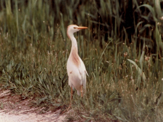
We’ve seen worse, but this winter has been particularly tough for birds and mammals in the Lower Susquehanna River Watershed. Due to the dry conditions of late summer and fall in 2024, the wild food crop of seeds, nuts, berries, and other fare has been less than average. The cold temperatures make insects hard to come by. Let’s have a look at how some of our local generalist and specialist species are faring this winter.
House Sparrows (bottom) and House Finches (top) are generalists. To survive and thrive, they are adapted to a variety of habitats and types of food. House Sparrows live almost anywhere man-made structures are found. They are true omnivores and will eat almost anything, especially if they see something else try to eat it first. The House Sparrow’s close association with humans has allowed it to become the most widespread and successful living avian dinosaur. On a cold night, they’ll take shelter either within dense vegetation alongside a building or within the structure itself. Though not nearly as cosmopolitan, the House Finch has successfully colonized much of the eastern United States after escaping from captivity as a cage bird in New York during the middle of the twentieth century. Upon being trans-located here from the arid southwest, they adapted to suburbs and farmlands consuming primarily a granivore diet of seeds supplemented with seasonally available berries. They quickly became accustomed to offerings at bird-feeding stations as well. To survive the harsh winters in the northern sections of their range, eastern populations of House Finches are developing a pattern of migration. These movements are most evident in late fall when dozens or sometimes hundreds can be seen heading south over regional hawk-counting stations.Though they require dead trees for nesting and as places to find the grubs and adult insects upon which they primarily feed, woodpeckers including the Northern Flicker are generalists, seldom passing by a supply of fruits like these Poison Ivy berries as a source of winter food. Flickers regularly visit suburban areas where they’ll drop by at bird-feeding stations for suet. During the warmer months, they are the woodpecker most frequently seen on the ground where swarms of ants garner their full attention.The Pileated Woodpecker is seldom found outside of mature forests where it digs relentlessly to remove grubs and other infestations from dead wood. But it is not a true specialist……it too finds a supply of Poison Ivy berries to be indispensable during a cold winter day.The Ruby-crowned Kinglet is a generalist, feeding mostly on insects, but also consuming small seeds and some berries, including those of Poison Ivy. It nests well to our north in tall spruces and other evergreens. During migration and in winter, the Ruby-crowned Kinglet may be found in deciduous trees, brush, and tall grass in habitats ranging from forests to parks and suburbia. This male is displaying its seldom-seen red crown.The Golden-crowned Kinglet, seen here on a Poison Ivy vine, is more of a specialist than the Ruby-crowned species, though the two will often occur in mixed groups during the winter. The Golden-crowned Kinglet nests in Spruce-Fir forests and in conifers within mixed woodlands. Even during migration, and particularly in winter, these birds are seldom found far from a stand of large evergreens within which they find shelter for the night.The Hermit Thrush’s generalist lifestyle allows it to survive cold season weather in the Lower Susquehanna River Watershed. During summer, it breeds in coniferous and mixed woods from the northern parts of our valley north into Canada and feeds primarily on worms, insects, and other arthropods. During migration and in winter, the Hermit Thrush becomes a regular visitor to deciduous forests, woody parks and suburbs, particularly where a supply of wild berries is available to supplement its diet.Iconic as it pulls earthworms from lawns during the warmer months, the generalist American Robin is fully dependent upon a crop of berries to survive winter conditions in the lower Susquehanna valley. The drought afflicted wild food crop of 2024 has led to fewer robins spending the season here and has delayed the northward push of migrating birds until the ground thaws and the earthworms make the ground rumble once again.It’s insects for the nestlings during spring and summer, then berries through the winter for the cheerful Eastern Bluebirds, another generalist species.American Crows are an excellent example of a generalist species. They’ll go anywhere to find food and they’ll eat almost anything. Like the House Sparrow and several other generalists, they adapt very well to human activity and actually thrive on it. Garbage anyone?Another career generalist is the widely worshiped White-tailed Deity, a species adapted to nearly all man-made landscapes with adequate vegetation upon which to browse. Pushed to the limit during severe weather, some individuals will consume carrion and even resort to cannibalism.You might think the Great Blue Heron is a specialist. Nope, it’s an accomplished generalist. Great blues will live, feed, and breed on almost any body of fresh or brackish water. And their diet includes almost anything that swims. In winter, you’ll even see them in fields hunting mice and voles.The Red-shouldered Hawk is a generalist with a diet ranging from amphibians and reptiles to small rodents and large insects. Mostly regarded as a species of bottomlands, they’ll frequent woodland edges, roadsides, and suburbia during the winter months.During its periodic winter visits to the region, the American Tree Sparrow feeds on seeds among the grasses and forbs of semi-open country with scattered short shrubs and trees. A generalist species, it will show up at backyard bird-feeding stations, particularly during periods of inclement weather. In summer, the American Tree Sparrow nests in tundra with growths of stunted willows and spruce and their diet includes insects as a source of protein for themselves and their young.The White-crowned Sparrow has similar winter habitat preferences to the tree sparrows……it becomes adaptable and something of a generalist when searching for food during bad winter storms.The Savannah Sparrow is an omnivore favoring insects in summer and seeds in winter. Though very closely tied to its grassland habitat year-round, snow cover can push these birds to enter woodier environs to consume fruits like these rose hips.Dusk and dawn during the short days of winter are the prime hunting times of a mammal specialist, the Short-eared Owl. Its presence in the lower Susquehanna valley is dependent on two dominant factors: extensive grassland habitat and an adequate population of the owl’s favored food, the Meadow Vole (Microtus pennsylvanicus). The Short-eared Owl’s requirements as a specialist species make finding a suitable place to live difficult. Unlike the generalist birds and mammals that often adapt to the widespread man-made disturbances in the region, populations of specialists frequently become fragmented, reduced in abundance, and subject to extirpation.The Meadow Vole is a generalist rodent that can be abundant in grasslands, early successional growth, fallow fields, marshlands, and, of course, meadows. They are primarily herbivores, but will occasionally consume insects and other arthropods. Usually nocturnal, some individuals venture out along their surface runways during daylight hours becoming vulnerable to diurnal raptors including kestrels, harriers, and buteos.A Short-eared Owl in near darkness patrolling a grassland for Meadow Voles.The eastward expansion of the Coyote (Canis latrans), a species of western North America’s grasslands and scrublands, and its progressive mixing with the Wolf (Canis lupus) in these eastern extensions of its range, has produced an expanding population of very adaptable generalists we call Eastern Coyotes (Canis latrans var.). These omnivorous canines colonized the Lower Susquehanna River Watershed during the last four decades to replace extirpated wolves as the top-tier natural predator in the region. Their primary diet includes Meadow Voles in grasslands and other small mammals along woodland edges and in successional habitats. Seasonally, they consume the berries of numerous wild plants. Slightly larger than their western ancestors, Eastern Coyotes with the admixture of Wolf genetics can subdue small ungulates. Like other apex predators, they are attracted to vulnerable prey and thus play a crucial role in culling the weak and diseased among their potential quarry species to assure the health and potential of populations of these species as long-term sources of food energy. The benefit to the prey species is however largely diluted in populous areas of the northeast; most venison consumed by Eastern Coyotes here is in the form of road kill. During periods of extended snow cover when small rodents and other foods become inaccessible, Eastern Coyotes, particularly young individuals, will wander into new areas seeking sustenance. Sometimes they venture into cities and suburbs where they explore the neighborhoods in search of garbage and pet foods placed outside the home. (Video clip courtesy of Tyler and Grace Good. Click image to view.)
Wildlife certainly has a tough time making it through the winter in the lower Susquehanna valley. Establishing and/or protecting habitat that includes plenty of year-round cover and sources of food and water can really give generalist species a better chance of survival. But remember, the goal isn’t to create unnatural concentrations of wildlife, it is instead to return the landscape surrounding us into more of a natural state. That’s why we try to use native plants as much as possible. And that’s why we try to attract not only a certain bird, mammal, or other creature, but we try to promote the development of a naturally functioning ecosystem with a food web, a diversity of pollinating plants, pollinating insects, and so on. Through this experience, we stand a better chance of understanding what it takes to graduate to the bigger job at hand—protecting, enhancing, and restoring habitats needed by specialist species. These are efforts worthy of the great resources that are sometimes needed to make them a success. It takes a mindset that goes beyond a focus upon the welfare of each individual animal to instead achieve the discipline to concentrate long-term on the projects and processes necessary to promote the health of the ecosystems within which specialist species live and breed. It sounds easier than it is—the majority of us frequently become distracted.
Being an individual from a population of a very successful generalist species is no guarantee of survival. This Eastern Gray Squirrel fell from a tall tree when the limbs became ice covered during a storm earlier this month. Just a freak accident? Maybe, but mistakes like this are often fatal in the natural world. This squirrel’s passing may seem brutal, but it provides a better opportunity for other squirrels and animals that share its food and cover requirements to make it through the winter. And those survivors that didn’t suffer such a fatal mistake or, more importantly, don’t possess a vulnerability that may have contributed to such a mishap will have a chance to pass those traits on to a new generation. This squirrel as an individual is gone, its species lives on, and may be stronger for its passing.Pennsylvania Game Commission crews maintain a grassland ecosystem for Short-eared Owls and other specialists using prescribed fire to prevent succession beyond its earliest stages. Among the additional specialist species benefiting from this management tool are Monarchs and other butterflies whose host plants survive early-season fire, but not competition with woody vines, shrubs, trees, and invasive herbaceous growth.
On the wider scale, it’s of great importance to identify and protect the existing and potential future habitats necessary for the survival of specialist species. And we’re not saying that solely for their benefit. These protection measures should probably include setting aside areas on higher ground that may become the beach intertidal zone or tidal marsh when the existing ones become inundated. And it may mean finally getting out of the wetlands, floodplains, and gullies to let them be the rain-absorbing, storm-buffering, water purifiers they spent millennia becoming. And it may mean it’s time to give up on building stick structures on tinderbox lands, especially hillsides and rocky outcrops with shallow, eroding soils that dry to dust every few years. We need to think ahead and stop living for the view. If you want to enjoy the view from these places, go visit and take plenty of pictures, or a video, that’s always nice—then live somewhere else. Each of these areas includes ecosystems that meet the narrow habitat requirements of many of our specialist species, and we’re building like fools in them. Then we feign victimhood and solicit pity when the calamity strikes: fires, floods, landslides, and washouts—again and again. Wouldn’t it be a whole lot smarter to build somewhere else? It may seem like a lot to do for some specialist animals, but it’s not. Because, you see, we should and can live somewhere else—they can’t.
The Allegheny Woodrat (Neotoma magister), a threatened species in Pennsylvania and a critically imperiled species in Maryland, is a habitat specialist requiring the forested rocky slopes, talus-flanked ridgetops, and caves of the Ridge and Valley Province for its nest sites and survival. Isolated populations survived within similar environs in the lower Susquehanna River valley’s Piedmont Province and on South Mountain through at least the first half of the twentieth century, but have since been extirpated. Human encroachment that fragments their habitat and promotes exposure to parasite-hosting mammals including the Raccoon (Procyon lotor), carrier of the Raccoon Roundworm (Baylisascarius procyonis), could prove fatal to remaining populations of this native mammal. (National Park Service image by Rick Olsen)The American Oystercatcher (Haematopus palliatus) is a specialist species that uses its highly adapted bill to feed on marine invertebrates including mollusks, few of which are actually oysters. Reliant upon tidal ecosystems for its survival, many of the seashore animals that make up this wader’s diet are themselves specialist species. Oystercatchers spend nearly their entire lives in tidal marshes or within the intertidal zone on beaches. They also frequent rocky jetties, particularly during high tide. This individual was photographed near the mouth of Chesapeake Bay in Northhampton County, Virginia, a location that, when the waters of the Atlantic started rising over 10,000 years ago, was the lower Susquehanna valley about 60 miles from the river’s mouth at present-day Norfolk Canyon along the edge of the continental shelf. Get the drift?
With low relative humidity, gusty daytime breezes, and little or no rain in the forecast, many counties and local municipalities in the lower Susquehanna basin have enacted bans on open burning to prevent accidental wildfires. With these dangerous conditions prevailing, you know enough not to burn trash and leaves, or to carelessly discard ashes or smoking materials. And you’re smart enough to keep close watch on fires used for cooking and to keep them within approved enclosures such as a grill with a lid. But have you thought of eliminating another common form of ignition, this one originating from your car or truck? Your motor vehicle’s catalytic converter is hot enough to ignite dry leaves, grasses, and crop residues like corn shocks upon contact, so be extra careful where you park. Be certain that your pollution control device remains free and clear of combustibles!
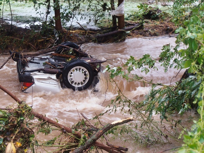
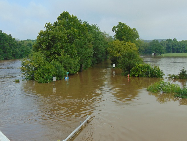
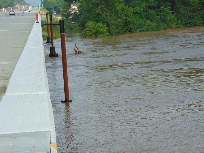
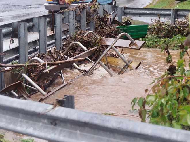
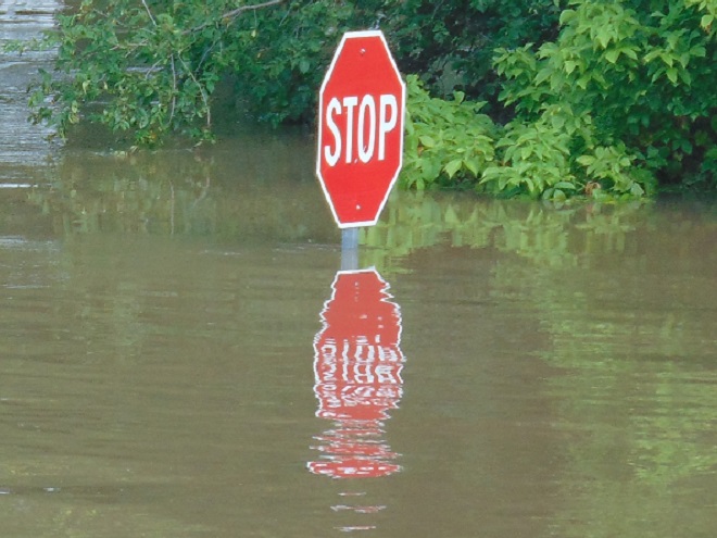
The deluge of rain that soaked the lower Susquehanna watershed during last week is now just a memory. Streams to the west of the river, where the flooding courtesy of the remnants of Hurricane Debby was most severe, have reached their crest and receded. Sliding away toward the Chesapeake and Atlantic is all that runoff, laden with a brew of pollutants including but not limited to: agricultural nutrients, sediment, petroleum products, sewage, lawn chemicals, tires, dog poop, and all that litter—paper, plastics, glass, Styrofoam, and more. For aquatic organisms including our freshwater fish, these floods, particularly when they occur in summer, can compound the effects of the numerous stressors that already limit their ability to live, thrive, and reproduce.
(Environmental Protection Agency image)
One of those preexisting stressors, high water temperature, can be either intensified or relieved by summertime precipitation. Runoff from forested or other densely vegetated ground normally has little impact on stream temperature. But segments of waterways receiving significant volumes of runoff from areas of sun-exposed impervious ground will usually see increases during at least the early stages of a rain event. Fortunately, projects implemented to address the negative impacts of stormwater flow and stream impairment can often have the additional benefit of helping to attenuate sudden rises in stream temperature.
While a row of trees along a creek can help provide protection from the thermal impact of the sun, a vegetative riparian buffer must be much wider to be effective for absorbing, cooling, and treating runoff from fields, lawns, and paved surfaces. This buffer is too narrow to prevent surface runoff from polluting the water.
Of the fishes inhabiting the Lower Susquehanna River Watershed’s temperate streams, the least tolerant of summer warming are the trouts and sculpins—species often described as “coldwater fishes”. Coldwater fishes require water temperatures below 70° Fahrenheit to thrive and reproduce. The optimal temperature range is 50° to 65° F. In the lower Susquehanna valley, few streams are able to sustain trouts and sculpins through the summer months—largely due to the effects of warm stormwater runoff and other forms of impairment.
Sculpins, including the Blue Ridge Sculpin (Cottus caeruleomentum) seen here, are native coldwater fishes which, during the 11,000 years since the last glacial maximum, have had the availability of their favored habitat sharply reduced by warming water temperatures and a rising Atlantic. During this interval, seawater has inundated the path of the “Late” Pleistocene lower Susquehanna which passed through the section of flooded river watershed we now call Chesapeake Bay and continued across the continental shelf to what was, during the glacial maximum, the river’s mouth at Norfolk Canyon. Today, cut off from neighboring drainage basins, sculpins survive exclusively in cold headwaters, and only in those where human alterations including pollution, dams, channelization, and reduced base flow haven’t yet eliminated their isolated populations. Formerly believed to be composed of two widespread North American species, the Slimy Sculpin (Cottus cognatus) and the Mottled Sculpin (Cottus bairdii), study in recent decades is discovering that sculpin populations in the present-day lower Susquehanna and neighboring Potomac headwaters consist of at least three newly delineated species: Blue Ridge Sculpin, Potomac Sculpin (Cottus gerardi), and Checkered Sculpin (Cottus sp.), the latter an as yet undescribed species found only in the refugium of limestone springs in the Potomac drainage in West Virginia; Frederick and Washington Counties, Maryland; and Franklin County, Pennsylvania. (United States Geological Survey image)Stare at this for a little while, you’ll figure it out…………More than 11,000 years ago, during the end of the last glacial period, when sea level was about 275 feet lower than it is today, there was no Chesapeake Bay, just a great Susquehanna River that flowed to the edge of the continental shelf and its mouth at Norfolk Canyon. It was a river draining taiga forests of pine, spruce , and fir, and it carried along the waters of all the present-day bay’s tributaries and more. The section of the river’s watershed we presently call the lower Susquehanna was, at the time, the upper Susquehanna watershed. Brook Trout and sculpins had the run of the river and its tributaries back then. And the entire watershed was a coldwater fishery, with limestone and other groundwater springs providing not refuge from summer heat, but a place to escape freezing water. (United States Geological Survey base image)Norfolk Canyon, the mouth of the Susquehanna River during the most recent glacial maximum, now lies more than 275 feet below the surface of the ocean and plunges to more than a mile in depth along the finger of out wash from the gorge. (United States Geological Survey image)Tens of thousands of trout are raised in state-operated and cooperative nurseries for stocking throughout the lower Susquehanna valley. These rearing facilities are located on spring-fed headwaters with sufficient flow to assure cold temperatures year round. While the Rainbow Trout and Brown Trout (Salmo trutta) are the most commonly stocked species, the Brook Trout (Salvelinus fontinalis) is the only one native to American waters. It is the least tolerant of stream warming and still reproduces in the wild only in a few pristine headwaters streams in the region. During spring, all three of these species have been observed on rare occasions entering the fish lift facilities at the hydroelectric dams on the river, presumably returning to the Susquehanna as sea-run trout.
Coldwater fishes are generally found in small spring-fed creeks and headwaters runs. Where stream gradient, substrate, dissolved oxygen, and other parameters are favorable, some species may be tolerant of water warmer than the optimal values. In other words, these temperature classifications are not set in stone and nobody ever explained ichthyology to a fish, so there are exceptions. The Brown Trout for example is sometimes listed as a “coldwater transition fish”, able to survive and reproduce in waters where stream quality is exceptionally good but the temperature may periodically reach the mid-seventies.
The Eastern Blacknose Dace is sometimes classified as a “coldwater transition fish”. It can be found in headwaters runs as well as in creeks with good water quality.The Longnose Dace is another “coldwater transition fish” known only from clear, clean, flowing waters.
More tolerant of summer heat than the trouts, sculpins, and daces are the “coolwater fishes”—species able to feed, grow, and reproduce in streams with a temperature of less than 80° F, but higher than 60° F. Coolwater fishes thrive in creeks and rivers that hover in the 65° to 70° F range during summer.
The Creek Chub is a familiar species of “coolwater fish” seldom found remaining in waters exceeding 80 degrees Fahrenheit.The Yellow Perch (Perca flavescens) was perhaps the most frequently targeted coolwater “gamefish” in the Lower Susquehanna River Watershed prior to the introduction of the Northern Pike (Esox lucius) and Muskellunge (Esox masquinongy). Today’s prevalence of warmwater streams and the dozens of species of non-native predatory fishes now naturalized within them have left the Yellow Perch populations greatly reduced and all but forgotten by anglers. Out of sight, out of mind. (National Park Service image)
What are the causes of modern-day reductions in coldwater and coolwater fish habitats in the lower Susquehanna River and its hundreds of miles of tributaries? To answer that, let’s take a look at the atmospheric, cosmic, and hydrologic processes that impact water temperature. Technically, these processes could be measured as heat flux—the rate of heat energy transfer per unit area per unit time, frequently expressed as watts per meter squared (W/m²). Without getting too technical, we’ll just take a look at the practical impact these processes have on stream temperatures.
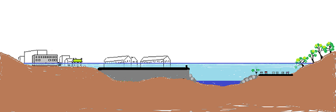
HEAT FLUX PROCESSES IN A SEGMENT OF STREAM
Heat Flux Processes on Stream and River Segments. These processes could be measured as heat flux—the rate of heat energy transfer per unit area per unit time. (Environmental Protection Agency image)
INCOMING TEMPERATURE AND FLOW—The baseline temperature of stream water entering a given segment of waterway is obviously the chief factor determining its temperature when exiting that segment. Incoming temperature and flow also determine the water’s susceptibility to heat absorption or loss while transiting the segment. Lower flows may subject the given volume of water to a greater loss or gain of heat energy during the time needed to pass through the segment than the same volume at a higher flow. Lower flows may also reduce stream velocity and extend a given volume of water’s exposure time to the exchange of heat energy while moving through the segment. Generally speaking…
…the higher the stream flow, the less a given volume of that stream’s water may be impacted by the effects of the heat flux processes within the segment.
…the lower the stream flow, the more a given volume of that stream’s water may be impacted by the effects of the heat flux processes within that segment.
…the temperature and flow rate of precipitation entering the segment are factors that determine the impact of its heat energy transfer to or from a given volume of the stream’s waters.
…the temperature and flow rate of runoff and point-source discharges entering the segment are factors that determine the impact of their heat energy transfer to or from a given volume of the stream’s waters.
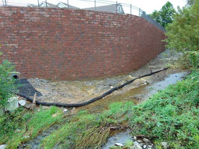
Stormwater from impervious surfaces including roads, parking lots, roofs, and lawns quickly impacts temperatures in small creeks. Channelized streams are availed few of the positive attributes provided by many of the heat flux processes we’re about to see. They therefore suffer from severe impairment and are exposed to temperature extremes that few aquatic organisms can survive. Runoff from sun-heated pavement during a summer thunderstorm can often exceed 100 degrees Fahrenheit and can, at sufficient flow rate, quickly raise the temperature of a small stream to well over 90 degrees.Stormwater runoff not only poses a thermal threat to waterways, its a significant source of a wide variety of pollutants.
GROUNDWATER INPUT—In streams connected to the aquifer, the temperature in a flowing segment can be impacted by the influx of cold groundwater. With temperatures ranging from about 52° to 60° Fahrenheit, groundwater will absorb heat from the stream in summer, and warm it in the winter. In warmwater streams, coldwater and coolwater fishes will often seek areas of the substrate where groundwater is entering for use as refugium from the summer heat. Yellow Perch in the lower Susquehanna are known to exhibit this behavior.
Creeks and rivers connected to the aquifer and receiving supplemental flow from it are known as “gaining streams”. These streams frequently feed water into the aquifer as well. (United States Geological Survey image)When flowing through an area experiencing drought or an excessive removal of groundwater (lots of wells, etc.), a waterway can become a “losing stream”, one that surrenders a portion of its flow to recharge the aquifer. Further downstream, the reduced flow can make such a creek or river more susceptible to the effects of heat flux processes. (United States Geological Survey image)Seriously depleted aquifers can lead to a “disconnected stream”. Smaller waterways subjected to these conditions will sometimes lose all their flow to the ground, often causing a catastrophic failure of the aquatic ecosystem supported therein. (United States Geological Survey image)Urban runoff overwhelms this small stream with polluted water than can reach temperatures of 100 degrees or more (left), then lets it high and dry with no baseflow during periods of dry weather (right) as the waterway becomes disconnected from the much-depleted aquifer.Well-designed and properly constructed stormwater retention basins not only recharge groundwater supplies for wells and streams, they can also help prevent thermal pollution in waterways. Planted with native wetland species and allowed to thrive, they can become treasured wildlife islands in otherwise inhospitable environs. The benefits don’t stop there; plants also help sequester nutrients contained in the runoff.
HYPORHEIC EXCHANGE—Related to groundwater input, hyporheic exchange is the slow movement of water through the rock, sand, gravel, and soils composing the streambed, saturated shoreline, shallow aquifer, and connected floodplain of a creek or river. As a heat flux process, hyporheic exchange helps moderate extremes in seasonal water temperatures by conducting energy between the solid materials in the zone and the flowing water. Hyporheic zones are important habitats for many species of aquatic invertebrates and spawning fish. Natural chemical processes within these zones convert ammonia-producing wastes into nitrite, then nitrate, allowing it to be absorbed as food by plants growing in the stream or in the alluvium within the zone. Vegetation removal, channelization, legacy sediments, silt deposits, and man-made walls and dams can negate the benefits of hyporheic exchange.
Exchange of surface and ground water within the hyporheic zone is most directly associated with high-gradient (left) and meandering (right) segments of streams. (United States Geological Survey image)Very common on streams in the lower Susquehanna valley are these accumulations of legacy sediments at the sites of former mill ponds. After the dams were removed, the creeks began eroding their way down through the mire as they tried to reestablish their floodplains and find their native substrate. These trapped waterways are not only cut off from their hyporheic zones, they’re now a major source of nutrient and sediment pollution. Misguided landowners like this one frequently dump fill into these sites to “save their land” and “control flooding”. The fill and materials added to “shore up the banks” do nothing to fix what ails the creek, but instead displace more water to make the impact of flooding even more widespread.Rehabilitation projects that remove legacy sediments help restore hyporheic exchange by reconnecting the stream to its underlying geology, its floodplain, and its wetlands. Rising waters remain in the floodplain where they get a good bio-scrubbing and help replenish the creek and groundwater supply. As the experts say, “floodplains are for flooding.”
ATMOSPHERIC EXCHANGE (CONVECTION, EVAPORATION)—Primarily a process by which a stream loses heat energy and cools its waters, atmospheric exchange is also a means by which a warm air mass can relinquish heat to cooler waters and thus increase their temperature. This phenomenon can be dramatically enhanced when a stream passes through a so-called urban heat island where air temperatures remain warm through the night. Convection, the movement of heat energy through a fluid (liquid or gas), causes warmer, less-dense water to rise to the surface of a stream, particularly where there is minimal turbulence. When the air above is cooler than the water’s surface layer, the stream will conduct heat energy across the water/atmosphere interface causing the warmed air molecules to rise in a convection column. If the atmospheric relative humidity is less than 100%, some surface water will vaporize—a process that expends more of the stream’s heat energy. The rate of convective and evaporative cooling in a given stream segment is directly related to the degree of difference between the water temperature and air temperature, and to the relative humidity in the air mass above the lake, creek, or river. The mechanical action of stream turbulence including rapids, riffles, and falls increases the contact area between air and water to maximize the atmospheric exchange of heat energy. The convective air current we call surface wind has a turbulent wave-producing effect on water that can also maximize atmospheric exchange; think of a cold autumn wind robbing heat energy from a warm lake or river or a hot summer wind imparting its heat to a cooler creek. These exchanges are both conductive in nature (air-to-water/water-to-air) and evaporative, the latter being expedited by the movement of dry air over warm water.
Usually classified as one of the coolwater fishes, the bottom-dwelling Tessellated Darter can thrive in the warmer creeks and in the main stem of the Susquehanna by inhabiting riffles where atmospheric exchange in the form of increased evaporation helps reduce temperatures and convective currents carry the cooler, well-oxygenated water to the streambed.Humans utilize the concept of atmospheric exchange, adopting the phenomena of evaporation and convection to cool the hot waters produced during electric generation and other industrial processes before discharge into a lake or river.
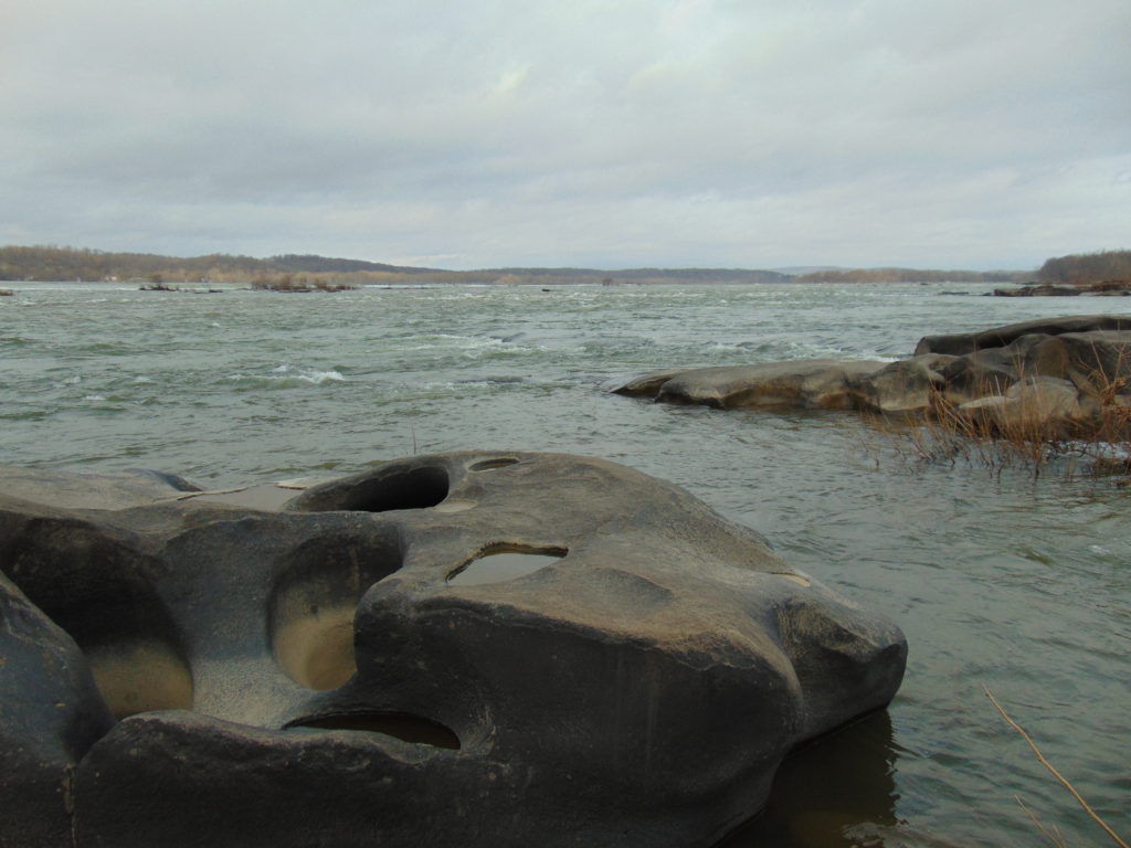
STREAMBED CONDUCTIVE EXCHANGE—In the lower Susquehanna watershed, there may be no better natural example of streambed conductive exchange than the Triassic-Jurassic diabase pothole bedrocks of Conewago Falls on the river at the south end of Three Mile Island.
During sunny days, the massive diabase pothole rocks at Conewago Falls absorb solar (shortwave) radiation, then conduct that heat energy into the flowing water, often continuing to pass the accumulated warmth into the river during the night. On cloudy days, the riverbed collects longwave atmospheric radiation, a heat flux process that yields significantly less energy for conduction into the rapids, riffles, and pools of the falls. During periods of low river flow, the heating effect of streambed conductive exchange can become magnified. Compared to conditions that prevail when torrents of turbid water are rushing through the falls, partially exposed bedrock surrounded by clear water collects radiated energy much more efficiently, then conducts the heat to a greatly reduced volume of passing water. During summer and autumn, this process can create a mix of temperature zones within the falls with warmer water lingering in slow-moving pools and cooler water flowing in the deeper fast-moving channels. Along the falls’ mile-long course, a haven is created for aquatic organisms including warmwater and some coolwater fishes, oft times attracting anglers and a variety of hungry migrating birds as well.Classified as one of our coolwater fishes, the Fallfish finds favorable conditions for feeding, growing, and spawning in the well-oxygenated waters of Conewago Falls.Though the lower Susquehanna River is classified as a warmwater fishery, the Northern Hog Sucker (Hypentelium nigricans), another of our native coolwater fishes, finds the fast-moving waters of Conewago Falls to its liking. Northern Hog Suckers are known to inhabit streams cold enough to host trout. They exhibit remarkable home range fidelity, sometimes spending their entire lives occupying the same several hundred feet of waterway. Northern Hog Suckers are often designated an indicator of good water quality, intolerant of many stream impairment parameters. Their presence in Conewago Falls provides testament to the quality of the warmwater fishery there.An unnatural example. The reduced base flow in this channelized and severely impaired creek has been rendered vulnerable to the negative impacts of several heat flux processes including streambed conductive exchange. Urban stormwater/surfacewater inflow, solar (shortwave) radiation, and heat conducted into the stream from the masonry walls, curbs, and raceway can all conspire to cook aquatic organisms with life-quenching summer water temperatures exceeding 90 degrees Fahrenheit.
SOLAR (SHORTWAVE) RADIATION—The sun provides the energy that fuels the earth’s complex climate. The primary heat flux process that heats our planet is the absorption of solar radiation in the shortwave spectrum, which includes ultraviolet, visible, and infrared frequencies at the upper end of the longwave spectrum. Streams and other bodies of water absorb the greatest amounts of solar (shortwave) radiation during the weeks around summer solstice when the sun at mid-day is closer to zenith than at any other time of the year. However, the heating impact of the radiation may be greatest when the volume of water in the creek, river, or lake is at its minimum for the year—often during early fall.
The rate, measured in watts per square meter, at which solar (shortwave) energy is directly radiated to a given area on the earth’s surface (including streams and other waters) is determined by: solar activity, the angle of the sun in the sky, aspect (slope) of the receiving surface, the opacity of the overlying atmosphere, and the distance of the earth from the sun. The former varies with the year’s seasons, the time of day, and the latitude of a given area. The latter is currently at its annual minimum when earth is at perihelion during the early days of January, thus providing the northern hemisphere with a little bump in radiation during the shortest days of the year when the sun is at its lowest angle in the sky. (NASA image)A varying portion of the solar (shortwave) radiation reaching the earth is reflected back into space by clouds. A smaller share is absorbed by the atmosphere, thus heating it. An even lesser quantity is reflected back into space by water and land. The remainder of the energy is absorbed by the planet’s surfaces, its water and land. (NASA image)
INCIDENT SHORTWAVE RADIATION—Also known as insolation (incoming solar radiation), incident shortwave radiation is the sum total energy of both the direct solar radiation that travels to the earth’s surface unaffected by the atmosphere and the diffuse radiation, waves that have been weakened and scattered by constituents of the atmosphere before reaching the planet’s surface. On a cloudy day, the warming of terrestrial surfaces including streams and other bodies of water is the result of diffuse radiation. On days with any amount of sunshine at all, both direct and diffuse radiation heat our waters and lands.
Warmwater fishes such as the native Pumpkinseed (Lepomis gibbosus) thrive in sun-drenched 70-to-85-degree waters as long as other heat flux processes prevent sudden temperature increases and oxygen depletion.Mowed stream banks offer a waterway no protection from incoming solar (shortwave) radiation, nor terrestrial forms of impairment including nutrient-rich stormwater runoff and silt.
REFLECTED SHORTWAVE RADIATION—known as albedo, reflected solar (shortwave) radiation is energy directed away from the earth’s surface before being absorbed. A surface’s albedo value is basically determined by its color, black having little reflective value, white and silvery surfaces reflecting nearly all solar (shortwave) radiation away. A surface with no reflective properties has an albedo value of 0, while a totally reflective surface has a value of 1. Clean snow with a value of about 0.85 to 0.9 (85% to 90%) is a highly reflective surface; yellow snow isn’t as good. A stream, river, or lake blanketed with ice and snow will absorb very little solar energy and will rely upon other heat flux processes to trigger a melt and thaw. The surface of open water has a varying albedo value determined mostly by the angle of the sun. Solar radiation striking the water’s surface at a low angle is mostly reflected away, while that originating at an angle closer to zenith is more readily absorbed.
To avoid the heating effects of solar (shortwave) and atmospheric longwave radiation, coldwater and coolwater fishes require streams offering protection from full exposure to direct sunlight and cloud cover. Runs and creeks flowing beneath a closed canopy of forest trees are shielded from 25% or more of incoming radiation and are thus able to better maintain thermal stability during the most vulnerable period of the year for temperature-sensitive fishes, May through October.
LONGWAVE RADIATION—Radiation in the longwave spectrum is composed of infrared waves at frequencies lower than those of the shortwave spectrum. Longwave radiation, sometimes just called infrared radiation, is produced by the earth and its atmosphere and is propagated in all directions, day and night. It warms mostly the lower atmosphere which in turn warms the earth’s surface including its waters. Some longwave energy can even be radiated into the waterway from its own streambed—and the stream can return the favor. Other forms of mass surrounding a stream such as a rocky shoreline or a man-made structure such as bridge pier can trade longwave radiation with a waterway. The effect of these latter exchanges is largely trivial and never rivals the heat flux transfer of warm to cold provided by conduction.
Longwave radiation emissions slow as the temperature of the emitting mass decreases, just as they also increase with temperature of the mass. Longwave radiation emissions therefore decrease with altitude along with the temperature of the water vapor, carbon dioxide, methane, and other gases that produce them. As such, the highest reaches of the atmosphere have a greatly reduced capability of shedding longwave radiation into space. At ground level, lakes, creeks, and streams receive their greatest dose of longwave radiation while beneath the cover of low-lying clouds or fog. (NASA image)
CANOPY RADIATION—Trees emit longwave radiation that may have a limited heat flux impact on waterway temperature. This radiation is diffuse, of scattered effect, and scarcely detectable, particularly beneath multilayered dense canopies. Some of the infrared energy transmitted by the tree canopy is radiated skyward as well.
WATER RADIATION—Water, like all earthly matter composed of vibrating molecules, emits longwave radiation. This heat flux process provides an ongoing cooling effect to streams, rivers, lakes, and oceans—warmer ones shedding infrared energy at a faster rate than those that are cold.
Now that we have a basic understanding of the heat flux processes responsible for determining the water temperatures of our creeks and rivers, let’s venture a look at a few graphics from gauge stations on some of the lower Susquehanna’s tributaries equipped with appropriate United States Geological Survey monitoring devices. While the data from each of these stations is clearly noted to be provisional, it can still be used to generate comparative graphics showing basic trends in easy-to-monitor parameters like temperature and stream flow.
Each image is self-labeled and plots stream temperature in degrees Fahrenheit (bold blue) and stream discharge in cubic feet per second (thin blue).
The West Conewago Creek drains much of the Gettysburg Basin’s Triassic redbeds in Adams and northern York Counties in Pennsylvania and includes a small headwaters area in northern Maryland. The gauge station is located just a over a mile upstream from the waterway’s mouth on the Susquehanna just below Conewago Falls. Right through the summer heatwave, this 90-day graph shows a consistent daily pattern of daytime rises in temperature and nighttime cooling. To the right, a rapid cool down can be seen coinciding with two periods of high water, the first from a series of heavy thundershowers, the second from flooding caused by the remnants of Hurricane Debby. Notice that the early August downpours were so heavy that they cooled the hot surface runoff and waterway quickly, without creating a rise in stream temperature at the gauging station. Had this monitoring device been located on a small tributary in an area with an abundance of impervious surfaces, there would probably have been a brief rise in stream temperature prior to the cooldown. (United States Geological Survey image)
The daily oscillations in temperature reflect the influence of several heat flux processes. During the day, solar (shortwave) radiation and convection from summer air, especially those hot south winds, are largely responsible for the daily rises of about 5° F. Longwave radiation has a round-the-clock influence—adding heat to the stream during the day and mostly shedding it at night. Atmospheric exchange including evaporative cooling may help moderate the rise in stream temperatures during the day, and certainly plays a role in bringing them back down after sunset. Along its course this summer, the West Conewago Creek absorbed enough heat to render it a warmwater fishery in the area of the gauging station. The West Conewago is a shallow, low gradient stream over almost its entire course. Its waters move very slowly, thus extending their exposure time to radiated heat flux and reducing the benefit of cooling by atmospheric exchange. Fortunately for bass, catfish, and sunfish, these temperatures are in the ideal range for warmwater fishes to feed, grow, and reproduce—generally over 80° F, and ideally in the 70° to 85° F range. Coolwater fishes though, would not find this stream segment favorable. It was consistently above the 80° F maximum and the 60° to 70° F range preferred by these species. And coldwater fishes, well, they wouldn’t be caught dead in this stream segment. Wait, scratch that—the only way they would be caught in this segment is dead. No trouts or sculpins here.
The Codorus Creek drains primarily the carbonate valleys of York County to the south of the West Conewago watershed. This gauge station is located about a mile upstream from the creek’s mouth on the Susquehanna just below Haldeman Riffles. The graphic pattern is very similar to that of the West Conewago’s: daily heating and cooling cycles and a noticeable drop in stream temperature in early August caused by a day of thundershowers followed by the remnants of Hurricane Debby. (United States Geological Survey image)
Look closely and you’ll notice that although the temperature pattern on this chart closely resembles that of the West Conewago’s, the readings average about 5 degrees cooler. This may seem surprising when one realizes that the Codorus follows a channelized path through the heart of York City and its urbanized suburbs—a heat island of significance to a stream this size. Before that it passes through numerous impoundments where its waters are exposed to the full energy of the sun. The tempering factor for the Codorus is its baseflow. Despite draining a smaller watershed than its neighbor to the north, the Codorus’s baseflow (low flow between periods of rain) was 96 cubic feet per second on August 5th, nearly twice that of the West Conewago (51.1 cubic feet per second on August 5th). Thus, the incoming heat energy was distributed over a greater mass in the Codorus and had a reduced impact on its temperature. Though the Codorus is certainly a warmwater fishery in its lower reaches, coolwater and transitional fishes could probably inhabit its tributaries in segments located closer to groundwater sources without stress. Several streams in its upper reaches are in fact classified as trout-stocked fisheries.
This is a zoomed-in look at the previous graph showing the impact of a rainfall event on the water temperatures in Codorus Creek. Unlike the sharp declines accompanying the deluge of flood waters during the two events in early August, these lesser storms in late June generated just enough runoff to capture heat energy from impervious surfaces and warm the creek, temporarily breaking the daily heating/cooling cycle. Upstream in the immediate area of the runoff, the impact on the stream and/or its tributaries was probably much more dramatic, certainly raising temperatures into the nineties or above. (United States Geological Survey image)Kreutz Creek drains a carbonate bedrock area of York County and flows parallel to the Lincoln Highway (US 30) to enter the Susquehanna at Wrightsville. The gauging station is about one mile upstream from the creek’s mouth. (United States Geological Survey image)
The Kreutz Creek gauge shows temperature patterns similar to those in the West Conewago and Codorus data sets, but notice the lower overall temperature trend and the flow. Kreutz Creek is a much smaller stream than the other two, with a flow averaging less than one tenth that of the West Conewago and about one twentieth of that in the Codorus. And most of the watershed is cropland or urban/suburban space. Yet, the stream remains below 80° F through most of the summer. The saving graces in Kreutz Creek are reduced exposure time and gradient. The waters of Kreutz Creek tumble their way through a small watershed to enter the Susquehanna within twenty-four hours, barely time to go through a single daily heating and cooling cycle. As a result, their is no chance for water to accumulate radiant and convective heat over multiple summer days. The daily oscillations in temperature are less amplified than we find in the previous streams—a swing of about three degrees compared to five. This indicates a better balance between heat flux processes that raise temperature and those that reduce it. Atmospheric exchange in the stream’s riffles, forest cover, and good hyporheic exchange along its course could all be tempering factors in Kreutz Creek. From a temperature perspective, Kreutz Creek provides suitable waters for coolwater fishes.
Muddy Creek drains portions of southern York County through rolling farmland and woodlots. There are no large impoundments or widespread urban impacts in the watershed, which may help explain its slightly lower temperature trends. (United States Geological Survey image)
Muddy Creek is a trout-stocked fishery, but it cannot sustain coldwater species through the summer heat. Though temperatures in Muddy Creek may be suitable for coolwater fishes, silt, nutrients, low dissolved oxygen, and other factors could easily render it strictly a warmwater fishery, inhabited by species tolerant of significant stream impairment.
Chiques Creek drains mostly limestone farmland in northwestern Lancaster County. The gauging station is located near the stream’s mouth on the Susquehanna at Chiques (Chickies) Rock. Oscillations in temperature again resemble the other waterways, but daily highs remain almost entirely below 80 degrees. (United States Geological Survey image)
A significant number of stream segments in the Chiques watershed have been rehabilitated to eliminate intrusion by grazing livestock, cropland runoff, and other sources of impairment. Through partnerships between a local group of watershed volunteers and landowners, one tributary, Donegal Creek, has seen riparian buffers, exclusion fencing, and other water quality and habitat improvements installed along nearly ever inch of its run from Donegal Springs through high-intensity farmland to its mouth on the main stem of the Chiques just above its confluence with the Susquehanna. The improved water quality parameters in the Donegal support native coldwater sculpins and an introduced population of reproducing Brown Trout. While coldwater habitat is limited to the Donegal, the main stem of the Chiques and its largest tributary, the Little Chiques Creek, both provide suitable temperatures for coolwater fishes.
Streams in the Chiques Creek and similar limestone watersheds often pass through areas with significant bedrock formations. Heat flux processes including groundwater input, hyporheic exchange, and streambed conductive exchange can have a greater influence on water temperature along these segments.A breeding condition Eastern Balcknose Dace, one of the coldwater transition fishes found in the Chiques and its tributaries.The Common Shiner (Luxilus cornutus), a fish tolerant of warmwater streams, prefers cool, clear waters for spawning. For protection from late-spring and summer heat, breeding males may seek a section of creek with a streambed inflow of limestone groundwater to defend as their nesting territory.A closeup of the Chiques Creek graph showing what appears to be a little bump in temperature caused by surface runoff during a couple of late-May showers. Stream rehabilitation is an ongoing process and the pressures of land disturbances both old and new present challenges to those who make it their passion to fix the wrongs that have been inflicted upon our local waters. Even the exemplary Donegal Creek faces new threats from urbanization in one of its headwater areas several miles to the northwest of the historic springs. (United States Geological Survey image)Conewago Creek (East) drains primarily Triassic redbed farmlands in Dauphin, Lancaster, and Lebanon Counties. Much of the headwaters area is forested but is experiencing an increasing rate of encroachment by housing and some commercial development. Conewago Creek (East) enters the Susquehanna on the east side of Conewago Falls at Three Mile Island. The watershed is equipped with three U.S.G.S. gauge stations capable of providing temperature data. This first one is located just over a mile upstream of the creek’s mouth. (United States Geological Survey image)
Despite its meander through and receipt of water from high-intensity farmland, the temperature of the lower Conewago (East) maxes out at about 85° F, making it ideal for warmwater fishes and even those species that are often considered coolwater transition fishes like introduced Smallmouth Bass, Rock Bass, Walleye, and native Margined Madtom. This survivable temperature is a testament to the naturally occurring and planted forest buffers along much of the stream’s course, particularly on its main stem. But the Conewago suffers serious baseflow problems compared to other streams we’ve looked at so far. Just prior to the early August storms, flow was well below 10 cubic feet per second for a drainage area of more than fifty square miles. While some of this reduced flow is the result of evaporation, much of it is anthropogenic in origin as the rate of groundwater removal continues to increase and a recent surge in stream withdraws for irrigation reaches its peak during the hottest days of summer.
A juvenile Rock Bass.A juvenile Margined Madtom.A closer look at the Conewago Creek (East) graphic shows the temperature drop associated with a series of thundershowers and the remnants of Hurricane Debby in early August. Despite the baseflow being below five cubic feet per second, the cooling effect of the downpours as measured in the area of the gauge was significant enough to overwhelm any heating of runoff that may have occurred as precipitation drained across hardened soils or man-made impervious surfaces. (United States Geological Survey image)
A little side note—the flow rate on the Conewago at the Falmouth gauge climbed to about 160 cubic feet per second as a result of the remnants of Hurricane Debby while the gauge on the West Conewago at Manchester skyrocketed to about 20,000 cubic feet per second. Although the West Conewago’s watershed (drainage area) is larger than that of the Conewago on the east shore, it’s larger only by a multiple of two or three, not 125. That’s a dramatic difference in rainfall!
The Bellaire monitoring station on Conewago Creek (East) is located on the stream’s main stem just downstream from the mouth of Little Conewago Creek, a tributary with its origins in farmland and woodlots. (United States Geological Survey image)
The temperatures at the Bellaire monitoring station, which is located upstream of the Conewago’s halfway point between its headwaters in Mount Gretna and its mouth, are quite comparable to those at the Falmouth gauge. Although a comparison between these two sets of data indicate a low net increase in heat absorption along the stream’s course between the two points, it also suggests sources of significant warming upstream in the areas between the Bellaire gauge and the headwaters.
Data from the gauge site on the Little Conewago Creek shows a temperature averaging about five degrees cooler than the gauge several miles downstream on the main stem of the Conewago at Bellaire. (United States Geological Survey image)
The waters of the Little Conewago are protected within planted riparian buffers and mature woodland along much of their course to the confluence with the Conewago’s main stem just upstream of Bellaire. This tributary certainly isn’t responsible for raising the temperature of the creek, but is instead probably helping to cool it with what little flow it has.
A stream like the Little Conewago Creek with daily temperatures that remain mostly below 80 degrees and retreat to 75 degrees or less during the night can be suitable for coldwater transition fishes like these juvenile Eastern Blacknose Dace (top) and Longnose Dace.
Though mostly passing through natural and planted forest buffers above its confluence with the Little Conewago, the main stem’s critically low baseflow makes it particularly susceptible to heat flux processes that raise stream temperatures in segments within the two or three large agricultural properties where owners have opted not to participate in partnerships to rehabilitate the waterway. The headwaters area, while largely within Pennsylvania State Game Lands, is interspersed with growing residential communities where potable water is sourced from hundreds of private and community wells—every one of them removing groundwater and contributing to the diminishing baseflow of the creek. Some of that water is discharged into the stream after treatment at the two municipal sewer plants in the upper Conewago. This effluent can become quite warm during processing and may have significant thermal impact when the stream is at a reduced rate of flow. A sizeable headwaters lake is seasonally flooded for recreation in Mount Gretna. Such lakes can function as effective mid-day collectors of solar (shortwave) radiation that both warms the water and expedites atmospheric exchange.
The Conewago Creek (East) Watershed from the Bellaire U.S.G.S. Gauging Station (lower left) upstream to the headwaters in Mount Gretna. (United States Geological Survey image)
Though Conewago Creek (East) is classified as a trout-stocked fishery in its upper reaches in Lebanon County, its low baseflow and susceptibility to warming render it inhospitable to these coldwater fishes by late-spring/early summer.
Despite being considered a warmwater fish, the River Chub (Nocomis micropogon) will ascend streams like the Conewago to seek cooler, gravel-bottomed waters for spawning. Reduced baseflow has probably rendered the stream currently too small for this species on Pennsylvania State Game Lands in Colebrook where this specimen was photographed in 2018.The Golden Shiner, another warmwater fish, often ascends streams to enter cooler water. Juvenile Golden Shiners like this one will move into shallower headwaters not only to seek reduced temperatures, but to escape large predatory fishes as well.Irrigation of agricultural fields using a large portion of the already diminished baseflow in the Conewago Creek (East) just downstream of the Bellaire gauging station. Despite millions of dollars in investment to rehabilitate this Susquehanna valley stream, the riparian buffers and other practices can have little effect when the creek gets sucked down to just a trickle. Low baseflow is a hard nut to crack. It’s best prevented, not corrected.Hammer Creek, a trout-stocked fishery, originates, in part, within Triassic conglomerate in the Furnace Hills of Lebanon County, then flows north into the limestone Lebanon Valley where it picks up significant flow from other tributaries before working its way south back through the Furnace Hills into the limestone farmlands of Lancaster County. From there the stream merges with the Cocalico Creek, then the Conestoga River, and at last the Susquehanna. Note the tremendous daily temperature oscillations on this headwaters stream as it surges about 15 degrees each day before recovering back close to groundwater temperature by sunrise the next day. (United States Geological Survey image)Headwaters of Hammer Creek including Buffalo Springs, a significant source of cold groundwater feeding the western leg of the stream. The large dams on this section that created the Lebanon and Rexmont Reservoirs have been removed. (United States Geological Survey base image)
The removal of two water supply dams on the headwaters of Hammer Creek at Rexmont eliminated a large source of temperature fluctuation on the waterway, but did little to address the stream’s exposure to radiant and convective heat flux processes as it meanders largely unprotected out of the forest cover of Pennsylvania State Game Lands and through high-intensity farmlands in the Lebanon Valley. Moderating the temperature to a large degree is the influx of karst water from Buffalo Springs, located about two miles upstream from this gauging station, and other limestone springs that feed tributaries which enter the Hammer from the east and north. Despite the cold water, the impact of the stream’s nearly total exposure to radiative and other warming heat flux processes can readily be seen in the graphic. Though still a coldwater fishery by temperature standards, it is rather obvious that rapid heating and other forms of impairment await these waters as they continue flowing through segments with few best management practices in place for mitigating pollutants. By the time Hammer Creek passes back through the Furnace Hills and Pennsylvania State Game Lands, it is leaning toward classification as a coolwater fishery with significant accumulations of sediment and nutrients. But this creek has a lot going for it—mainly, sources of cold water. A core group of enthusiastic landowners could begin implementing the best management practices and undertaking the necessary water quality improvement projects that could turn this stream around and make it a coldwater treasure. An organized effort is currently underway to do just that. Visit Trout Unlimited’s Don Fritchey Chapter and Donegal Chapter to learn more. Better yet, join them as a volunteer or cooperating landowner!
The male Creek Chub, one of our coolwater fishes, develops head tubercles and becomes flushed with color during spawning season. Hammer Creek not only provides a home for the Creek Chub, its cold headwaters provide refuge for a population of native Brook Trout too.Like no other example we’ve looked at so far, this closeup of the Hammer Creek graphic shows temperature bumps correlating with the stormwater runoff from early August’s rains. Because the stream flow is small and the precipitation rate was not as great at this location, the effect of heat flux from runoff is more readily apparent. (United States Geological Survey image)Brook Trout adult and juvenile. (United States Fish and Wildlife Service image by Ryan Hagerty)
For coldwater fishes, the thousands of years since the most recent glacial maximum have seen their range slowly contract from nearly the entirety of the once much larger Susquehanna watershed to the headwaters of only our most pristine streams. Through no fault of their own, they had the misfortune of bad timing—humans arrived and found coldwater streams and the groundwater that feeds them to their liking. Some of the later arrivals even built their houses right on top of the best-flowing springs. Today, populations of these fishes in the region we presently call the Lower Susquehanna River Watershed are seriously disconnected and the prospect for survival of these species here is not good. Stream rehabilitation, groundwater management, and better civil planning and land/water stewardship are the only way coldwater fishes, and very possibly coolwater fishes as well, will survive. For some streams like Hammer Creek, it’s not too late to make spectacular things happen. It mostly requires a cadre of citizens, local government, project specialists, and especially stakeholders to step up and be willing to remain focused upon project goals so that the many years of work required to turn a failing stream around can lead to success.
Riparian buffers with fences to exclude livestock can immediately begin improving water quality. With establishment of such vegetative buffers, the effects of stressors that otherwise eliminate coldwater and coolwater fishes from these segments will begin to diminish.Within five to ten years, a riparian buffer planted with native trees is not only helping to reduce nutrient and sediment loads in the stream, it is also shielding the waters from heat flux processes including the solar (shortwave) radiation that raises water temperatures to levels not tolerated by coldwater and coolwater fishes.A well-established riparian buffer.A forested stream.
You’re probably glad this look at heat flux processes in streams has at last come to an end. That’s good, because we’ve got a lot of work to do.
Add one more benefit to the wildflower meadow, it infiltrates stormwater to recharge the aquifer much better than mowed grass. And another related plus, it reduces runoff and its thermal pollution. Besides, you don’t have time to mow grass, because we have work to do!Our native coldwater fishes including the Potomac Sculpin will survive only if we protect and expand the scattered few habitats where they have taken refuge. They have no choice but to live in these seriously threatened places, but we do. So let’s give ’em some space. How ’bout it? (United States Fish and Wildlife Service image by Ryan Hagerty)
Grasshoppers are perhaps best known for the occasions throughout history when an enormous congregation of these insects—a “plague of locusts”—would assemble and rove a region to feed. These swarms, which sometimes covered tens of thousands of square miles or more, often decimated crops, darkened the sky, and, on occasion, resulted in catastrophic famine among human settlements in various parts of the world.
The largest “plague of locusts” in the United States occurred during the mid-1870s in the Great Plains. The Rocky Mountain Locust (Melanoplus spretus), a grasshopper of prairies in the American west, had a range that extended east into New England, possibly settling there on lands cleared for farming. Rocky Mountain Locusts, aside from their native habitat on grasslands, apparently thrived on fields planted with warm-season crops. Like most grasshoppers, they fed and developed most vigorously during periods of dry, hot weather. With plenty of vegetative matter to consume during periods of scorching temperatures, the stage was set for populations of these insects to explode in agricultural areas, then take wing in search of more forage. Plagues struck parts of northern New England as early as the mid-1700s and were numerous in various states in the Great Plains through the middle of the 1800s. The big ones hit between 1873 and 1877 when swarms numbering as many as trillions of grasshoppers did $200 million in crop damage and caused a famine so severe that many farmers abandoned the westward migration. To prevent recurrent outbreaks of locust plagues and famine, experts suggested planting more cool-season grains like winter wheat, a crop which could mature and be harvested before the grasshoppers had a chance to cause any significant damage. In the years that followed, and as prairies gave way to the expansive agricultural lands that presently cover most of the Rocky Mountain Locust’s former range, the grasshopper began to disappear. By the early years of the twentieth century, the species was extinct. No one was quite certain why, and the precise cause is still a topic of debate to this day. Conversion of nearly all of its native habitat to cropland and grazing acreage seems to be the most likely culprit.
The critically endangered Eskimo Curlew (Numenius borealis), a species not photographed since 1962 and not confirmed since 1963, fed on Rocky Mountain Locusts during its spring migration through the Great Plains. Excessive hunting and conversion of grasslands to agriculture are believed responsible for the bird’s demise. (United States Fish and Wildlife Service image by Christina Nelson)
In the Mid-Atlantic States, the mosaic of the landscape—farmland interspersed with a mix of forest and disturbed urban/suburban lots—prevents grasshoppers from reaching the densities from which swarms arise. In the years since the implementation of “Green Revolution” farming practices, numbers of grasshoppers in our region have declined. Systemic insecticides including neonicotinoids keep grasshoppers and other insects from munching on warm-season crops like corn and soybeans. And herbicides including 2,4-D (2,4-Dichlorophenoxyacetic acid) have, in effect, become the equivalent of insecticides, eliminating broadleaf food plants from the pasturelands and hayfields where grasshoppers once fed and reproduced in abundance. As a result, few of the approximately three dozen species of grasshoppers with ranges that include the Lower Susquehanna River Watershed are common here. Those that still thrive are largely adapted to roadsides, waste ground, and small clearings where native and some non-native plants make up their diet.
Here’s a look at four species of grasshoppers you’re likely to find in disturbed habitats throughout our region. Each remains common in relatively pesticide-free spaces with stands of dense grasses and broadleaf plants nearby.
CAROLINA GRASSHOPPER
Dissosteira carolina
The Carolina Grasshopper, also known as the Carolina Locust or Quaker, is one of the band-winged grasshoppers. It is commonly found along roadsides and on other bare ground near stands of tall grass and broadleaf plants.The Carolina Grasshopper is variable in color, ranging from very dark brown……to a rich tan or khaki shade. These earth-tone colors provide the insect with effective camouflage while spending time on the ground.The Carolina Grasshopper is most readily detected and identified when it flies. The colors of the wings resemble those of the Mourning Cloak butterfly.Carolina Grasshoppers are among the preferred victims of Great Black Wasps (Sphex pensylvanicus). A female wasp stings the grasshopper to paralyze it, then drags it away to one of numerous cells in an underground burrow where she lays an egg on it. The body of the disabled grasshopper then provides nourishment for the larval wasp.
DIFFERENTIAL GRASSHOPPER
Melanoplus differentialis
Differential Grasshopper nymph with small “fairy wings”.An adult female Differential Grasshopper with fully developed wings.An adult female Differential Grasshopper
TWO-STRIPED GRASSHOPPER
Melanoplus bivittatus
An early-stage Two-striped Grasshopper nymph.A Two-striped Grasshopper nymph in a later stage.An adult female Two-striped Grasshopper.An adult female Two-striped Grasshopper. Note the pale stripe originating at each eye and joining near the posterior end of the wings to form a V-shaped pattern.An adult female Two-striped Grasshopper.
RED-LEGGED GRASSHOPPER
Melanoplus femurrubrum
An adult male Red-legged Grasshopper hiding in dense urban vegetation.The Red-legged Grasshopper may currently be our most abundant and widespread species.An adult male Red-legged Grasshopper.An adult female Red-legged Grasshopper.
Protein-rich grasshoppers are an important late-summer, early-fall food source for birds. The absence of these insects has forced many species of breeding birds to abandon farmland or, in some cases, disappear altogether.
Beginning in the early 1930s, the Western Cattle Egret (Bubulcus ibis), a notoriously nomadic species, transited the Atlantic from Africa to colonize the Americas…and they did it without any direct assistance from humans. During the 1970s and early 1980s, a nesting population of Western Cattle Egrets on river islands adjacent to the Susquehanna’s Conejohela Flats off Washington Boro was the largest inland rookery in the northeastern United States. The Lancaster County Bird Club censused the birds each August and found peak numbers in 1981 (7,580). During their years of abundance, V-shaped flocks of cattle egrets from the rookery islands ventured into grazing lands throughout portions of Lancaster, York, Dauphin, and Lebanon Counties to hunt grasshoppers. These daily flights were a familiar summertime sight for nearly two decades. Then, in the early 1980s, reductions in pastureland acreage and plummeting grasshopper numbers quickly took their toll. By 1988, the rookery was abandoned. The cattle egrets had moved on. (Vintage 33 mm image)During the summer and early fall, juvenile and adult Ring-necked Pheasants feed heavily on grasshoppers. Earlier and more frequent mowing along with declining numbers of grasshoppers on farmlands due to an increase in pesticide use were factors contributing to the crash of the pheasant population in the early 1980s.To the delight of Wild Turkeys, each of the four species of grasshoppers shown above frequents clearings and roadsides adjacent to forest areas. While changes in grasshopper distribution have been detrimental to populations of birds like pheasants, they’ve created a feeding bonanza for turkeys.Wild Turkeys feeding on an abundance of grasshoppers along a forest road.An American Kestrel feeds on a grasshopper while ignoring the abundance of Spotted Lanternflies swarming the adjacent utility pole. In Susquehanna valley farmlands, grasshopper and kestrel numbers are down. Lanternflies, on the other hand, have got it made.Maintaining areas bordering roads, forests, wetlands, farmlands, and human development in a state of early succession can provide and ideal mix of mature grasses and broadleaf plants for grasshoppers, pollinators, birds, and other wildlife.
Back in late May of 1983, four members of the Lancaster County Bird Club—Russ Markert, Harold Morrrin, Steve Santner, and your editor—embarked on an energetic trip to find, observe, and photograph birds in the Lower Rio Grande Valley of Texas. What follows is a daily account of that two-week-long expedition. Notes logged by Markert some four decades ago are quoted in italics. The images are scans of 35 mm color slide photographs taken along the way by your editor.
DAY EIGHT—May 28, 1983
“Bentsen State Park, Texas”
“Alarm at 6:00 A.M. After breakfast we traveled to Falcon State Park and toured the whole camp area, stopping many places to observe birds. We ran up a good list.”
And so we left what had been our home for the last several days and headed west. In the forty years since our departure that morning, Bentsen-Rio Grande State Park has experienced a number of operational changes. Today, it is a World Birding Center site. For conducting the seasonal hawk census, a tower has been erected to provide counters and observes with an unrestricted view above the treetops. If you wanted to camp in the park now, you would need reservations and would have to hike your gear in to one of only a few primitive campsites. Trailer and motor home accommodations no longer exist. A tram service is now available for touring the park by motor vehicle.
West of Rio Grande City, we exited the river’s outflow delta and entered the Texas scrubland, an area mostly devoid of large trees except in moist soils immediately adjacent to the Rio Grande where the lush vegetation creates a dense subtropical riparian forest in many places. The reservoir itself is known to attract migrating and vagrant waterfowl, waders, shorebirds, gulls, terns, and seabirds. (United States Fish and Wildlife Service base image)
Falcon State Park is located along the east shore of Falcon Reservoir. There are no shade trees beneath which one can escape the scorching rays of the sun on a hot day. This is the easternmost section of the scrubland’s Tamaulipan Saline Thornscrub, a xeric plant community of head-high brush found only on clay soils with a particularly high salinity. Many of the plants look similar to other varieties of shrubs and small trees with which one may be familiar, except nearly all of them are covered with nasty thorns and prickles. And yes, there are cactus. You can’t make your way bushwhacking cross country without obtaining cuts, gashes, and scars to show for it. The Falcon State Recreation Area bird checklist published in 1977 has a nice description of the plants found there—mesquite, ebano, guaycan, blackbrush and catclaw acacia, granjeno, coyotillo, huisache, tasajillo, prickly pear, allthorn, cenizo, colima, and yucca. In the margins between the thornscrub growth, there is an abundance of grasses and wildflowers. On nearby ridges, Tamaulipan Calcareous Thornscrub, a similar xeric plant community, occupies soils with a higher content of calcium carbonate. Together, these communities make up much of the Tamaulipan Mezquital ecoregion of scrublands in Starr County and western Hidalgo County in the Rio Grande valley of Texas.
After being greeted by a Greater Roadrunner at the campsite, we took a walk to the nearby shoreline of the reservoir. We spotted Olivaceous Cormorants perched on some dead limbs in the water nearby. Known today as Neotropic Cormorant (Phalacrocorax brasilianus), it is yet another specialty of the Rio Grande Valley. Elsewhere on or near the water—Cattle Egret, Great Egret, Black-bellied Whistling Duck, Osprey, Common Gallinule, Killdeer, Laughing Gull, Forster’s Tern (Sterna forsteri), Least Tern, and Caspian Tern were seen.
The Greater Roadrunner is right at home in the Tamaulipan Saline Thornscrub habitat in and around Falcon State Park. This one came to check us out soon after our arrival at our campsite. Roadrunners prey on insects, rodents, and lizards including the Texas Spotted Whiptail (Aspidoscelis gularis), a species which we found nearby.
In the thornscrub around the campground, which, like Bentsen-Rio Grande State Park, we had pretty much to ourselves, we saw Scissor-tailed Flycatcher, Curve-billed Thrasher, White-winged Dove, Mourning Dove, Ground Dove, Inca Dove, and White-tipped Dove. A single Chihuahuan Raven was a fly by. We saw and smelled several road-killed Nine-banded Armadillos (Dasypus novemcinctus), but never found one alive.
Then, it started to rain. Not just a shower, but a soaker that persisted through much of the day. Rainy days can make for great birding, so we kept at it. Unfortunately, such days aren’t too ideal for photography, so we did only what we could without ruining our equipment.
In the campground at Falcon State Park, a Cactus Wren (Campylorhynchus brunneicapillus) takes shelter from the rain beneath a canopy protecting a picnic table.Looks like a good idea, others soon sought shelter there as well.
“Finally we drove to the spillway of the dam and parked.”
Falcon Dam was another of the numerous flood-control projects built on the Rio Grande during the middle of the twentieth century. Behind it, Falcon Reservoir stores water for irrigation and operation of a hydroelectric generating station located within the dam complex. Construction of the dam and power plant was a joint venture shared by Mexico and the United States. The project was dedicated by Presidents Adolfo Ruiz Cortines and Dwight D. Eisenhower in 1953.
Rainy days aside, the route precipitation takes to reach the Falcon Reservoir and the Lower Rio Grande Valley includes hundreds of miles through arid grasslands and scrublands. Along the way, much of that water is lost to natural processes including evaporation and aquifer recharge, but an increasing percentage of the volume is being removed by man for civil, industrial, and agricultural uses. Can the Rio Grande and its tributaries continue to meet demand?
The Rio Grande’s headwaters can be found in south-central Colorado where spring snow melt is vital to establishing adequate flow to allow the river to recharge aquifers in the hundreds of miles of arid lands through which it flows. Presently, dams in the upper reaches of the river are operated to hold water during the spring thaw, then release it slowly to compensate for base flow lost to withdrawals for irrigation in extensive areas of the middle reaches of the watershed. With everyone wanting their take, is there enough water to go around? Diminishing ground water levels suggest the answer is no. (National Oceanic and Atmospheric Administration base image)Using the streamflow recharge process, the flowing Rio Grande provides water to the aquifers in the arid regions through which it passes. Click the image for a slightly larger version. (United States Geological Survey image)
“On the way in we saw and photographed an apparent sick or injured Swainson’s Hawk. We approached it very close.”
The Swainson’s Hawk (Buteo swainsoni), a bird of prairies and other grasslands, is an abundant migrant through the Lower Rio Grande Valley in both spring and fall. This one was grounded, rain-soaked, and obviously running late. Others of its kind were by now on their breeding grounds in the Great Plains and Rocky Mountains.The bird allowed us to approach without attempting to flee, which isn’t a good sign. We looked for any obvious physical injuries and found none.The continuous rain had the hawk’s feathers matted down and soaked.Was its water-logged plumage the problem, or was it the result of its inability to thrive due to an illness? We had no way of telling, so we let it be and vowed to stop back later to check on it.Steve the hawk whisperer?
“At the spillway we sat in the camper, except when the rain slackened, then we stood out and watched in vain for the Green or Ringed Kingfisher, which we never did see.”
At the spillway House Sparrows, Rough-winged Swallows, and Cliff Swallows were nesting on the dam, the latter two species grabbing flying insects above the waters of the Rio Grande.
Despite the rain, anglers were fishing along the spillway walls where this young man caught a Longnose Gar (Lepisosteus osseus). The reservoir has been stocked with Alligator Gar (Atractosteus spatula), Spotted Gar (Lepisosteus oculatus), and a variety of bass, catfish, and other species to establish a trophy sport fishery. Many specimens grow to become trophy-size there due to the warm water temperatures. These guys though were fishing for food, not trophies.
“I made dinner here at this spillway and we continued to watch. The rain almost stopped, so we walked down the road about 1 1/2 miles, during which time we saw a lifer for Harold — Hook-billed Kite. We followed Father Tom’s directions to a spot for the Ferruginous Owl — no luck.”
A Red-billed Pigeon in a willow tree in the subtropical riparian forest along the banks of the Rio Grande below Falcon Dam. Prior to this trip, neither Steve nor I had ever seen this tropical species before.
“Back at the spillway we had supper and then repeated the hike — no Ferruginous Owl, but a Barn Owl and Great Horned Owl. Back to our #201 campsite and wrote up the day’s log.”
Trees along the river provided habitat for orioles and other species. Since the rain had subsided, we decided to see what might come out and begin feeding. Soon, we not only saw an Altamira Oriole, but found Hooded Oriole (Icterus cucullatus) and the yellow and black tropical species, Audubon’s Oriole (Icterus graduacauda), formerly known as Black-headed Oriole. Three species of orioles on a backdrop of lush green subtropical foliage, it was magnificent.
Along the dirt road below the dam, the mix of scrubland and subtropical riparian forest made for excellent birding. We not only found a soaring Hook-billed Kite, one of the target birds for the trip, but we had good looks at both a Great Horned Owl, then a Barn Owl (Tyto alba) that we flushed from the bare ground in openings among the vegetation as we walked the through. Both had probably pounced on some sort of small prey species prior to our arrival. Because there are seldom crows or ravens to bother them, owls here are more active during than day than they are elsewhere. The subject of this afternoon’s intensive search, the elusive and diminutive Ferruginous Pygmy Owl (Glaucidium brasilianum), is routinely diurnal. Other sightings on our two walks included Turkey Vulture, Black Vulture, White-tailed Kite, Northern Bobwhite, Yellow-billed Cuckoo, Golden-fronted Woodpecker, Ladder-backed Woodpecker, Couch’s Kingbird, Brown-crested Flycatcher, Green Jay, Black-crested Titmouse, Mockingbird, Long-billed Thrasher, Great-tailed Grackle, Bronzed Cowbird, Northern Cardinal, and Painted Bunting.
The day finished as so many others had earlier during the trip—with insect-hunting Common Nighthawks calling from the skies around our campsite.
During the spare time you have on a rainy day like today, you may have asked yourself, “Just how much water do people collect with those rain barrels they have attached to their downspouts?” That’s a good question. Let’s do a little math to figure it out.
First, we need to determine the area of the roof in square feet. There’s no need to climb up there and measure angles, etc. After all, we’re not ordering shingles—we’re trying to figure out the surface area upon which rain will fall vertically and be collected. For our estimate, knowing the footprint of the building under roof will suffice. We’ll use a very common footprint as an example—1,200 square feet.
40′ x 30′ = 1,200 sq. ft.
By dividing the area of the roof by 12, we can calculate the volume of water in cubic feet that is drained by the spouting for each inch of rainfall…
1,200 ÷ 12 = 100 cu. ft. per inch of rainfall
Next, we multiply the volume of water in cubic feet by 7.48 to convert it to gallons per inch of rainfall…
100 x 7.48 = 748 gallons per inch of rainfall
That’s a lot of water. Just one inch of rain could easily fill more than a single rain barrel on a downspout. Many homemade rain barrels are fabricated using recycled 55-gallon drums. Commercially manufactured ones are usually smaller. Therefore, we can safely say that in the case of a building with a footprint of 1,200 square feet, an array of at least 14 rain barrels is required to collect and save just one inch of rainfall. Wow!
Why send that roof water down the street, down the drain, down the creek, or into the neighbors property? Wouldn’t it be better to catch it for use around the garden? At the very least, shouldn’t we be infiltrating all the water we can into the ground to recharge the aquifer? Why contribute to flooding when you and I are gonna need that water some day? Remember, the ocean doesn’t need the excess runoff—it’s already full.
It was a routine occurrence in many communities along tributaries of the lower Susquehanna River during the most recent two months. The rain falls like it’s never going to stop—inches an hour. Soon there is flash flooding along creeks and streams. Roads are quickly inundated. Inevitably, there are motorists caught in the rising waters and emergency crews are summoned to retrieve the victims. When the action settles, sets of saw horses are brought to the scene to barricade the road until waters recede. At certain flood-prone locations, these events are repeated time and again. The police, fire, and Emergency Medical Services crews seem to visit them during every torrential storm—rain, rescue, rinse, and repeat.
We treat our local streams and creeks like open sewers. Think about it. We don’t want rainwater accumulating on our properties. We pipe it away and grade the field, lawn, and pavement to roll it into the neighbor’s lot or into the street—or directly into the waterway. It drops upon us as pure water and we instantly pollute it. It’s a method of diluting all the junk we’ve spread out in its path since the last time it rained. A thunderstorm is the big flush. We don’t seem too concerned about the litter, fertilizer, pesticides, motor fluids, and other consumer waste it takes along with it. Out of sight, out of mind.
Failure to retain and infiltrate stormwater to recharge aquifers can later result in well failures and reduced base flow in streams. (Conoy Creek’s dry streambed in June, 2007)
Perhaps our lack of respect for streams and creeks is the source of our complete ignorance of the function of floodplains.
Floodplains are formed over time as hydraulic forces erode bedrock and soils surrounding a stream to create adequate space to pass flood waters. As floodplains mature they become large enough to reduce flood water velocity and erosion energy. They then function to retain, infiltrate, and evaporate the surplus water from flood events. Microorganisms, plants, and other life forms found in floodplain wetlands, forests, and grasslands purify the water and break down naturally-occurring organic matter. Floodplains are the shock-absorber between us and our waterways. And they’re our largest water treatment facilities.
Why is it then, that whenever a floodplain floods, we seem motivated to do something to fix this error of nature? Man can’t help himself. He has a compulsion to fill the floodplain with any contrivance he can come up with. We dump, pile, fill, pave, pour, form, and build, then build some more. At some point, someone notices a stream in the midst of our new creation. Now it’s polluted and whenever it storms, the darn thing floods into our stuff—worse than ever before. So the project is crowned by another round of dumping, forming, pouring, and building to channelize the stream. Done! Now let’s move all our stuff into our new habitable space.
Natural Floodplain- Over a period of hundreds or thousands of years, the stream (dark blue) has established a natural floodplain including wetlands and forest. In this example, buildings and infrastructure are located outside the zone inundated by high water (light blue) allowing the floodplain to function as an effective water-absorbing buffer.Impaired Floodplain- Here the natural floodplain has been filled for building (left) and paved for recreation area parking (right). The stream has been channelized. Flood water (light blue) displaced by these alterations is likely to inundate areas not previously impacted by similar events. Additionally, the interference with natural flow will create new erosion points that could seriously damage older infrastructure and properties.
The majority of the towns in the lower Susquehanna valley with streams passing through them have impaired floodplains. In many, the older sections of the town are built on filled floodplain. Some new subdivisions highlight streamside lawns as a sales feature—plenty of room for stockpiling your accoutrements of suburban life. And yes, some new homes are still being built in floodplains.
When high water comes, it drags tons of debris with it. The limbs, leaves, twigs, and trees are broken down by natural processes over time. Nature has mechanisms to quickly cope with these organics. Man’s consumer rubbish is another matter. As the plant material decays, the embedded man-made items, particularly metals, treated lumber, plastics, Styrofoam, and glass, become more evident as an ever-accumulating “garbage soil” in the natural floodplains downstream of these impaired areas. With each storm, some of this mess floats away again to move ever closer to Chesapeake Bay and the Atlantic. Are you following me? That’s our junk from the curb, lawn, highway, or parking lot bobbing around in the world’s oceans.
A shed, mobile home, or house can be inundated or swept away during a flood. Everything inside (household chemicals, gasoline, fuel oil, pesticides, insulation, all those plastics, etc.) instantly pollutes the water. Many communities that rely on the Susquehanna River for drinking water are immediately impacted, including Lancaster, PA and Baltimore, MD. This dumpster was swept away from a parking lot in a floodplain. It rolled in the current, chipping away at the bridge before spilling the rubbish into the muddy water. After the flood receded, the dumpster was found a mile downstream. Its contents are still out there somewhere.Floodplains along the lower Susquehanna River are blanketed with a layer of flotsam that settles in place as high water recedes. These fresh piles can be several feet deep and stretch for miles. Nature decomposes the organic twigs and driftwood to build soil-enriching humus. However, the plastics and other man-made materials that do not readily decay or do not float away toward the sea during the next flood are incorporated into the alluvium and humus creating a “garbage soil”. Over time, the action of abrasives in the soil will grind small particles of plastics from the larger pieces. These tiny plastics can become suspended in the water column each time the river floods. What will be the long-term impact of this type of pollution?Anything can be swept away by the powerful hydraulic forces of flowing water. Large objects like this utility trailer can block passages through bridges and escalate flooding problems.The cost of removing debris often falls upon local government and is shared by taxpayers.Here, a junked boat dock is snagged on the crest of the York Haven Dam at Conewago Falls. Rising water eventually carried it over the dam and into the falls where it broke up. This and tons of other junk are often removed downstream at the Safe Harbor Dam to prevent damage to turbine equipment. During periods of high water, the utility hauls debris by the truck-load to the local waste authority for disposal. For the owners of garbage like this dock, it’s gone and it’s somebody else’s problem now.Motor vehicles found after floating away from parking areas in floodplains can create a dangerous dilemma for police, fire, and E.M.S. personnel, particularly when no one witnesses the event. Was someone driving this car or was it vacant when it was swept downstream? Should crews be put at risk to locate possible victims?
Beginning in 1968, participating municipalities, in exchange for having coverage provided to their qualified residents under the National Flood Insurance Program, were required to adopt and enforce a floodplain management ordinance. The program was intended to reduce flood damage and provide flood assistance funded with premiums paid by potential victims. The program now operates with a debt incurred during severe hurricanes. Occurrences of repetitive damage claims and accusations that the program provides an incentive for rebuilding in floodplains have made the National Flood Insurance Program controversial.
In the Lower Susquehanna River Watershed there are municipalities that still permit new construction in floodplains. Others are quite proactive at eliminating new construction in flood-prone zones, and some are working to have buildings removed that are subjected to repeated flooding.
Another Wall— Here’s an example of greed by the owner, engineer, and municipality… placing their financial interests first. The entire floodplain on the north side of this stream was filled, then the wall was erected to contain the material. A financial institution’s office and parking lot was constructed atop the mound. This project has channelized the stream and completely displaced half of the floodplain to a height of 15 to 20 feet. Constructed less than five years ago, the wall failed already and has just been totally reconstructed. The photo reveals how recent flooding has begun a new erosion regime where energy is focused along the base of the wall. Impairment of a floodplain to this degree can lead to flooding upstream of the site and erosion damage to neighboring infrastructure including roads and bridges.The floodplain along this segment of the lower Swatara Creek in Londonderry Township, Dauphin County is free to flood. Ordinances prohibit new construction here and 14 older houses that repeatedly flooded were purchased, dismantled, and removed using funding from the Federal Emergency Management Agency (F.E.M.A). A riparian buffer was planted and some wetland restorations were incorporated into stormwater management installations along the local highways. When the waters of the Swatara rise, the local municipality closes the roads into the floodplain. Nobody lives or works there anymore, so no one has any reason to enter. There’s no need to rescue stubborn residents who refused advice to evacuate. Sightseers can park and stand on the hill behind the barricades and take all the photographs they like.A new Pennsylvania Turnpike bridge across Swatara Creek features wide passage for the stream below. Water flowing in the floodplain can pass under the bridge without being channelized toward the path where the stream normally flows in the center. The black asterisk-shaped floats spin on the poles to help deflect debris away from the bridge piers. (flood crest on July 26, 2018)People are curious when a waterway floods and they want to see it for themselves. Wouldn’t it be wise to anticipate this demand for access by being ready to accommodate these citizens safely? Isn’t a parking lot, picnic area, or manicured park safer and more usable when overlooking the floodplain as opposed to being located in it? Wouldn’t it be a more prudent long-term investment, both financially and ecologically, to develop these improvements on higher ground outside of flood zones?Now would be a good time to stop the new construction and the rebuilding in floodplains. Aren’t the risks posed to human life, water quality, essential infrastructure, private property, and ecosystems too great to continue?Isn’t it time to put up the white flag and surrender the floodplains to the floods? That’s why they’re there. Floodplains are for flooding.
It was one of the very first of my memories. From the lawn of our home I could look across the road and down the hill through a gap in the woodlands. There I could see water, sometimes still with numerous boulders exposed, other times rushing, muddy, and roaring. Behind these waters was a great stone wall and beyond that a wooded hillside. I recall my dad asking me if I could see the dam down there. I couldn’t see a dam, just fascinating water and the gray wall behind it. I looked and searched but not a trace of a structure spanning the near to far shore was to be seen. Finally, at some point, I answered in the affirmative to his query; I could see the dam…but I couldn’t.
We lived in a small house in the village of Falmouth along the Susquehanna River in the northwest corner of Lancaster County over fifty years ago. A few years after we had left our riverside domicile and moved to a larger town, the little house was relocated to make way for an electric distribution sub-station and a second set of electric transmission wires in the gap in the woodlands. The Brunner Island coal-fired electric generating station was being upgraded downstream and, just upstream, a new nuclear-powered generating station was being constructed on Three Mile Island. To make way for the expanding energy grid, our former residence was trucked to a nearby boat landing where there were numerous other river shacks and cabins. Because it was placed in the floodplain, the building was raised onto a set of wooden stilts to escape high water. It didn’t help. The record-breaking floods of Hurricane Agnes in June of 1972 swept the house away.
The view through the cut in the woodland, a little wider than in the early 1960s with the addition of the newer electric transmission wire towers. The “Wall” is the same.
During the time we lived along the Susquehanna, the river experienced record-low flow rates, particularly in the autumn of 1963 and again in 1964. My dad was a dedicated 8mm home-movie photographer. Among his reels was film of buses parked haphazardly along the road (PA Route 441 today) near our home. Sightseers were coming to explore the widely publicized dry riverbed and a curious moon-like landscape of cratered rocks and boulders. It’s hard to fathom, but people did things like that during their weekends before Sunday-afternoon football was invented. Scores of visitors climbed through the rocks and truck-size boulders inspecting this peculiar scene. My dad, his friends, and so many others with camera in hand were experiencing the amazing geological feature known as the Pothole Rocks of Conewago Falls.
Conewago Falls on the Susquehanna River and several exposed York Haven Diabase Pothole Rocks. Lancaster (foreground) and Dauphin (center) Counties meet along a southwest to northeast borderline through the rapids. Lands on the west shoreline in the background are in York County. Three Mile Island is seen in the upper right.
The river here meets serious resistance as it pushes its way through the complex geology of south-central Pennsylvania. These hard dark-gray rocks, York Haven Diabase, are igneous in origin. Diabase sheets and sills intruded the Triassic sediments of the Gettysburg Formation here over 190 million years ago. It may be difficult to visualize, but these sediments were eroded from surrounding mountains into the opening rift valley we call the Gettysburg Basin. This rift and others in a line from Nova Scotia to Georgia formed as the supercontinent Pangaea began dividing into the continents we know today. Eventually the Atlantic Ocean rift would dominate as the active dynamic force and open to separate Africa from North America. The inactive Gettysburg Basin, filled with sediments and intruded by igneous diabase, would henceforth, like the mountainous highlands surrounding it, be subjected to millions of years of erosion. Of the regional rocks, the formations of Triassic redbeds, sandstones, and particularly diabase in the Gettysburg Basin are among the more resistant to the forces of erosion. Many less resistant older rocks, particularly those of surrounding mountains, are gone. Today, the remains of the Gettysburg Basin’s rock formations stand as rolling highlands in the Piedmont Province.
Flooded from the heavy rains of Tropical Storm Lee, the sediment-laden Susquehanna River flows through the Gettysburg Basin just south of Harrisburg, PA, September 10, 2011. The “Wall” as seen from space. (NASA Earth Observatory Image)
The weekend visitors in 1963 and 1964 marveled at evidence of the river’s fight to break down the hard York Haven Diabase. Scoured bedrock traced the water’s turbulent flow patterns through the topography of the falls. Meltwater from the receding glaciers of the Pleistocene Ice Ages thousands to tens of thousands of years ago raged in high-volume, abrasive-loaded torrents to sculpt the Pothole Rocks into the forms we see today. Our modern floodwaters with ice and fine suspended sediments continue to wear at the smooth rocks and boulders, yet few are broken or crumbled to be swept away. It’s a very slow process. The river elevation here drops approximately 19 feet in a quarter of a mile, a testament to the bedrock’s persisting resistance to erosion. Conewago Falls stands as a natural anomaly on a predominantly uniform gradient along the lower Susquehanna’s downhill path from the Appalachian Mountains to the Chesapeake Bay.
Normally the scene of dangerous tumbling rapids, the drought and low water of 1963 and 1964 had left the falls to resemble a placid scene—a moonscape during a time when people were obsessed with mankind’s effort to visit earth’s satellite. Visitors saw the falls as few others had during the twentieth century. Dr. Herbert Beck of Franklin and Marshall College described an earlier period of exposure, “…pot holes…were uncovered during the third week in October, 1947, for the first time in the memory of man, when the drought parched Susquehanna River retreated far below its normal low stage”. Then, as in 1963 and on occasions more recent, much of it was due to the presence of the wall. I had to be a bit older than four years old to grasp it. You see the wall and the dam are one and the same. The wall is the York Haven Dam. And it is responsible for channeling away the low flow of the Susquehanna during periods of drought so that we might have the opportunity to visit and explore the Pothole Rocks of Conewago Falls along the river’s east shore.
The initial segment of the dam, a crib structure built in 1885 by the York Haven Paper Company to supply water power to their mill, took advantage of the geomorphic features of the diabase bedrock of Conewago Falls to divert additional river flow into the abandoned Conewago Canal. The former canal, opened in 1797 to allow passage around the rapids along the west shore, was being used as a headrace to channel water into the grinding mill’s turbines. Strategic placement of this first wall directed as much water as possible toward the mill with the smallest dam practicable. The York Haven Power Company incorporated the paper mill’s crib dam into the “run-of-the-river” dam built through the falls from the electric turbine powerhouse they constructed on the west shore to the southern portion of Three Mile Island more than a mile away. The facility began electric generation in 1904. The construction of the “Red Hill Dam” from the east shore of Three Mile Island to the river’s east shore made York Haven Dam a complete impoundment on the Susquehanna. The pool, “Lake Frederic”, thus floods that portion of the Pothole Rocks of Conewago Falls located behind the dam. On the downstream side, water spilling over or through the dam often inundates the rocks or renders them inaccessible.
During the droughts of the early 1960s, diversion of nearly all river flow to the York Haven Dam powerhouse cleared the way for weekend explorers to see the Pothole Rocks in detail. Void of water, the intriguing bedrock of Conewago Falls below the dam greeted the curious with its ripples, cavities, and oddity. It was an opportunity nature alone would not provide. It was all because of the wall.
York Haven Dam and powerhouse. The “Wall” traverses Conewago Falls upstream to Three Mile Island to direct water to the powerhouse on the west shore of the Susquehanna River.
SOURCES
Beck, Herbert H. 1948. “The Pot Holes of Conewago Falls”. Proceedings of the Pennsylvania Academy of Science. Penn State University Press. 22: pp. 127-130.
Smith, Stephen H. 2015. #6 York Haven Paper Company; on the Site of One of the Earliest Canals in America. York Past website www.yorkblog.com/yorkpast/2015/02/17/6-york-haven-paper-company-on-the-site-of-one-of-the-earliest-canals-in-america/ as accessed July 17, 2017.
Stranahan, Susan Q. 1993. Susquehanna, River of Dreams. The Johns Hopkins University Press. Baltimore, Maryland.
Van Diver, Bradford B. 1990. Roadside Geology of Pennsylvania. Mountain Press Publishing Company. Missoula, Montana.


 Radiation")


 Watershed")