The rain and clouds have at last departed. With blue skies and sunshine to remind us just how wonderful a spring afternoon can be, we took a stroll at Memorial Lake State Park in Lebanon County, Pennsylvania, to look for some migratory birds.
Though running just a few days later than usual, Indigo Buntings have arrived to begin nesting.This Common Loon dropped by Memorial Lake during a storm several days ago and decided to stay awhile. It’s a species that winters in oceanic waters along the Atlantic seaboard and nests on glacial lakes to our north.Because of the low level of turbidity in Memorial Lake, visibility is good enough to allow this benthic feeder an opportunity to see food before expending energy to dive down and retrieve it. Favorable foraging conditions might be part of the reason this bird is hanging around.Clear Water- Memorial Lake is one of the few man-made lakes in the Lower Susquehanna River Watershed to be appropriately vegetated with an abundance of submerged, floating, and emergent plants. As a result, the water from Indiantown Run that passes through the impoundment is minimally impacted by nutrient loads and the algal blooms they can cause. Buffers of woody and herbaceous growth along the lake’s shorelines provide additional nutrient sequestering and help prevent soil erosion and siltation.The breeding season has begun for Neotropical migrants including this Baltimore Oriole, which we found defending a nesting territory in a stand of Black Walnut trees.Along the edge of the lake, this Orchard Oriole and its mate were in yet another stand of tall walnut trees.Early in the season and early in the day, we started seeing Common Nighthawks flying above wooded areas north of the lake at 4 o’clock this afternoon. After all the raw and inclement weather they’ve experienced in recent days, the warm afternoon was probably their first opportunity to feed on flying insects in quite a while.Early birds, Common Nighthawks feeding at 4 P.M.
What? You thought we were gonna drop in on Maryland’s largest city for a couple of ball games and some oysters, clams, and crab cakes—not likely.
At this very moment, your editor is comfortably numb and is, if everything is going according to plans, again having a snake run through the plumbing in his body’s most important muscle. It thus occurs to him how strange it is that with muscles as run down and faulty as his, people at one time asked him to come speak about and display his marvelous mussels. And some, believe it or not, actually took interest in such a thing. If the reader finds this odd, he or she would not be alone. But the peculiarities don’t stop there. The reader may find further bewilderment after being informed that the editor’s mussels are now in the collection of a regional museum where they are preserved for study by qualified persons with scientific proclivities. All of this show and tell was for just one purpose—to raise appreciation and sentiment for our mussels, so that they might be protected.
Click on the “Freshwater Mussels and Clams” tab at the top of this page to see the editor’s mussels, and many others as well. Then maybe you too will want to flex your muscles for our mussels. They really do need, and deserve, our help.
With the gasoline and gunpowder gang’s biggest holiday of the year now upon us, wouldn’t it be nice to get away from the noise and the enduring adolescence for just a little while to see something spectacular that isn’t exploding or on fire? Well, here’s a suggestion: head for the hills to check out the flowers of our native rhododendron, the Great Rhododendron (Rhododendronmaximum), also known as Rosebay.
The Great Rhododendron is an evergreen shrub found growing in the forest understory on slopes with consistently moist (mesic) soils. The large, thick leaves make it easy to identify. During really cold weather, they may droop and curl, but they still remain green and attached to the plant.
Thickets composed of our native heathers/heaths (Ericaceae) including Great Rhododendron, Mountain Laurel, and Pinxter Flower (Rhododendron periclymenoides), particularly when growing in association with Eastern Hemlock and/or Eastern White Pine, provide critical winter shelter for forest wildlife. The flowers of native heathers/heaths attract bees and other pollinating insects and those of the deciduous Pinxter Flower, which blooms in May, are a favorite of butterflies and Ruby-throated Hummingbirds.
A close relative of the Great Rhododendron is the Pinxter Flower, also known as the Pink Azalea.
Forests with understories that include Great Rhododendrons do not respond well to logging. Although many Great Rhododendrons regenerate after cutting, the loss of consistent moisture levels in the soil due to the absence of a forest canopy during the sunny summertime can, over time, decimate an entire population of plants. In addition, few rhododendrons are produced by seed, even under optimal conditions. Great Rhododendron seeds and seedlings are very sensitive to the physical composition of forest substrate and its moisture content during both germination and growth. A lack of humus, the damp organic matter in soil, nullifies the chances of successful recolonization of a rhododendron understory by seed. In locations where moisture levels are adequate for their survival and regeneration after logging, impenetrable Great Rhododendron thickets will sometimes come to dominate a site. These monocultures can, at least in the short term, cause problems for foresters by interrupting the cycle of succession and excluding the reestablishment of native trees. In the case of forests harboring stands of Great Rhododendron, it can take a long time for a balanced ecological state to return following a disturbance as significant as logging.
Ruffed Grouse (Bonasa umbellus) may be particularly sensitive to the loss of winter shelter and travel lanes provided by thickets of Great Rhododendron and other members of the heather/heath family. (Vintage 35 mm image)
In the lower Susquehanna region, the Great Rhododendron blooms from late June through the middle of July, much later than the ornamental rhododendrons and azaleas found in our gardens. Set against a backdrop of deep green foliage, the enormous clusters of white flowers are hard to miss.
Great Rhododendrons sport an attractive blossom cluster. The colors of the flower, especially the markings found only on the uppermost petal, guide pollinators to the stamens (male organs) and pistil (female organ).To this Bumble Bee (Bombus species), the yellowish spots on the uppermost petal of the Great Rhododendron may appear to be clumps of pollen and are thus an irresistible lure.
In the Lower Susquehanna River Watershed, there are but a few remaining stands of Great Rhododendron. One of the most extensive populations is in the Ridge and Valley Province on the north side of Second Mountain along Swatara Creek near Ravine (just off Interstate 81) in Schuylkill County, Pennsylvania. Smaller groves are found in the Piedmont Province in the resort town of Mount Gretna in Lebanon County and in stream ravines along the lower river gorge at the Lancaster Conservancy’s Ferncliff and Wissler’s Run Preserves. Go have a look. You’ll be glad you did.
Great Rhododendron along Route 125 along the base of the north slope of Second Mountain north of Ravine, Schuylkill County, Pennsylvania.Great Rhododendrons beginning to bloom during the second week of July along Swatara Creek north of Ravine, Schuylkill County, Pennsylvania. Note how acid mine drainage has stained the rocks in the upper reaches of this tributary of the lower Susquehanna. Mitigation of leachate pollutants from legacy mines has facilitated the return of over two dozen species of fish to this waterway, but the telltale discoloration of the stream substrate will remain for some time.
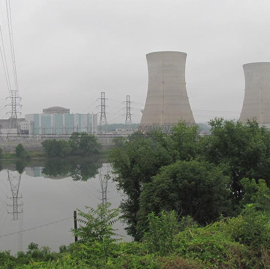
Fifty years ago this week, the remnants of Hurricane Agnes drifted north through the Susquehanna River basin as a tropical storm and saturated the entire watershed with wave after wave of torrential rains. The storm caused catastrophic flooding along the river’s main stem and along many major tributaries. The nuclear power station at Three Mile Island, then under construction, received its first major flood. Here are some photos taken during the climax of that flood on June 24, 1972. The river stage as measured just upstream of Three Mile Island at the Harrisburg gauge crested at 33.27 feet, more than 10 feet above flood stage and almost 30 feet higher than the stage at present. At Three Mile Island and Conewago Falls, the river was receiving additional flow from the raging Swatara Creek, which drains much of the anthracite coal region of eastern Schuylkill County—where rainfall from Agnes may have been the heaviest.
1972- From the river’s east shore at the mouth of Conewago Creek, Three Mile Island’s “south bridge” crosses the Susquehanna along the upstream edge of Conewago Falls. The flood crested just after covering the roadway on the span. Floating debris including trees, sections of buildings, steel drums, and rubbish began accumulating against the railings on the bridge’s upstream side, leading observers to speculate that the span would fail. When a very large fuel tank, thousands of gallons in capacity, was seen approaching, many thought it would be the straw that would break the camel’s back. It wasn’t, but the crashing sounds it made as it struck the bridge then turned and began rolling against the rails was unforgettable. (Larry L. Coble, Sr. image)1972- In this close-up of the preceding photo, the aforementioned piles of junk can be seen along the upstream side of the bridge (behind the sign on the right). The fuel tank struck and was rolling on the far side of this pile. (Larry L. Coble, Sr. image)2022- Three Mile Island’s “south bridge” as it appeared this morning, June 24,2022.1972- The railroad along the east shore at Three Mile Island’s “south bridge” was inundated by rising water. This flooded automobile was one of many found in the vicinity. Some of these vehicles were overtaken by rising water while parked, others were stranded while being driven, and still others floated in from points unknown. (Larry L. Coble, Sr. image)2022- A modern view of the same location.1972- At the north end of Three Mile Island, construction on Unit 1 was halted. The completed cooling towers can be seen to the right and the round reactor building can be seen behind the generator building to the left. The railroad grade along the river’s eastern shore opposite the north end of the island was elevated enough for this train to stop and shelter there for the duration of the flood. (Larry L. Coble, Sr. image)2022- Three Mile Island Unit 1 as it appears today: shut down, defueled, and in the process of deconstruction.1972- In March of 1979, the world would come to know of Three Mile Island Unit 2. During Agnes in June of 1972, flood waters surrounding the plant resulted in a delay of its construction. In the foreground, note the boxcar from the now defunct Penn Central Railroad. (Larry L. Coble, Sr. image)2022- A current look at T.M.I. Unit 2, shut down since the accident and partial meltdown in 1979.
Pictures capture just a portion of the experience of witnessing a massive flood. Sometimes the sounds and smells of the muddy torrents tell us more than photographs can show.
Aside from the booming noise of the fuel tank banging along the rails of the south bridge, there was the persistent roar of floodwaters, at the rate of hundreds of thousands of cubic feet per second, tumbling through Conewago Falls on the downstream side of the island. The sound of the rapids during a flood can at times carry for more than two miles. It’s a sound that has accompanied the thousands of floods that have shaped the falls and its unique diabase “pothole rocks” using abrasives that are suspended in silty waters after being eroded from rock formations in the hundreds of square miles of drainage basin upstream. This natural process, the weathering of rock and the deposition of the material closer to the coast, has been the prevailing geologic cycle in what we now call the Lower Susquehanna River Watershed since the end of the Triassic Period, more than two hundred million years ago.
More than the sights and sounds, it was the smell of the Agnes flood that warned witnesses of the dangers of the non-natural, man-made contamination—the pollution—in the waters then flowing down the Susquehanna.
Because they float, gasoline and other fuels leaked from flooded vehicles, storage tanks, and containers were most apparent. The odor of their vapors was widespread along not only along the main stem of the river, but along most of the tributaries that at any point along their course passed through human habitations.
Blended with the strong smell of petroleum was the stink of untreated excrement. Flooded treatment plants, collection systems overwhelmed by stormwater, and inundated septic systems all discharged raw sewage into the river and many of its tributaries. This untreated wastewater, combined with ammoniated manure and other farm runoff, gave a damaging nutrient shock to the river and Chesapeake Bay.
Adding to the repugnant aroma of the flood was a mix of chemicals, some percolated from storage sites along watercourses, and yet others leaking from steel drums seen floating in the river. During the decades following World War II, stacks and stacks of drums, some empty, some containing material that is very dangerous, were routinely stored in floodplains at businesses and industrial sites throughout the Susquehanna basin. Many were lifted up and washed away during the record-breaking Agnes flood. Still others were “allowed” to be carried away by the malicious pigs who see a flooding stream as an opportunity to “get rid of stuff”. Few of these drums were ever recovered, and hundreds were stranded along the shoreline and in the woods and wetlands of the floodplain below Conewago Falls. There, they rusted away during the next three decades, some leaking their contents into the surrounding soils and waters. Today, there is little visible trace of any.
During the summer of ’72, the waters surrounding Three Mile Island were probably viler and more polluted than at any other time during the existence of the nuclear generating station there. And little, if any of that pollution originated at the facility itself.
The Susquehanna’s floodplain and water quality issues that had been stashed in the corner, hidden out back, and swept under the rug for years were flushed out by Agnes, and she left them stuck in the stinking mud.
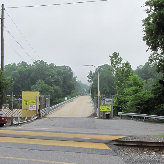
Second Mountain Hawk Watch is located on a ridge top along the northern edge of the Fort Indiantown Gap Military Reservation and the southern edge of State Game Lands 211 in Lebanon County, Pennsylvania. The valley on the north side of the ridge, also known as St. Anthony’s Wilderness, is drained to the Susquehanna by Stony Creek. The valley to the south is drained toward the river by Indiantown Run, a tributary of Swatara Creek.
The hawk watch is able to operate at this prime location for observing the autumn migration of birds, butterflies, dragonflies, and bats through the courtesy of the Pennsylvania Game Commission and the Garrison Commander at Fort Indiantown Gap. The Second Mountain Hawk Watch Association is a non-profit organization that staffs the count site daily throughout the season and reports data to the North American Hawk Watch Association (posted daily at hawkcount.org).
Today, Second Mountain Hawk Watch was populated by observers who enjoyed today’s break in the rainy weather with a visit to the lookout to see what birds might be on the move. All were anxiously awaiting a big flight of Broad-winged Hawks, a forest-dwelling Neotropical species that often travels back to its wintering grounds in groups exceeding one hundred birds. Each autumn, many inland hawk watches in the northeast experience at least one day in mid-September with a Broad-winged Hawk count exceeding 1,000 birds. They are an early-season migrant and today’s southeast winds ahead of the remnants of Hurricane Florence (currently in the Carolinas) could push southwest-heading “Broad-wings” out of the Piedmont Province and into the Ridge and Valley Province for a pass by the Second Mountain lookout.
The flight turned out to be steady through the day with over three hundred Broad-winged Hawks sighted. The largest group consisted of several dozen birds. We would hope there are probably many more yet to come after the Florence rains pass through the northeast and out to sea by mid-week. Also seen today were Bald Eagles, Ospreys, American Kestrels, and a migrating Red-headed Woodpecker.
Migrating Broad-winged Hawks circle on a thermal updraft above Second Mountain Hawk Watch to gain altitude before gliding away to the southwest.
Migrating insects included Monarch butterflies, and the three commonest species of migratory dragonflies: Wandering Glider, Black Saddlebags, and Common Green Darner. The Common Green Darners swarmed the lookout by the dozens late in the afternoon and attracted a couple of American Kestrels, which had apparently set down from a day of migration. American Kestrels and Broad-winged Hawks feed upon dragonflies and often migrate in tandem with them for at least a portion of their journey.
Still later, as the last of the Broad-winged Hawks descended from great heights and began passing by just above the trees looking for a place to settle down, a most unwelcome visitor arrived at the lookout. It glided in from the St. Anthony’s Wilderness side of the ridge on showy crimson-red wings, then became nearly indiscernible from gray tree bark when it landed on a limb. It was the dreaded and potentially invasive Spotted Lanternfly (Lycorma delicatula). This large leafhopper is native to Asia and was first discovered in North America in the Oley Valley of eastern Berks County, Pennsylvania in 2014. The larval stage is exceptionally damaging to cultivated grape and orchard crops. It poses a threat to forest trees as well. Despite efforts to contain the species through quarantine and other methods, it’s obviously spreading quickly. Here on the Second Mountain lookout, we know that wind has a huge influence on the movement of birds and insects. The east and southeast winds we’ve experienced for nearly a week may be carrying Spotted Lanternflies well out of their most recent range and into the forests of the Ridge and Valley Province. We do know for certain that the Spotted Lanternfly has found its way into the Lower Susquehanna River Watershed.
This adult Spotted Lanternfly landed in a birch tree behind the observers at the Second Mountain Hawk Watch late this afternoon. It was first recognized by its bright red wings as it glided from treetops on the north side of the lookout.
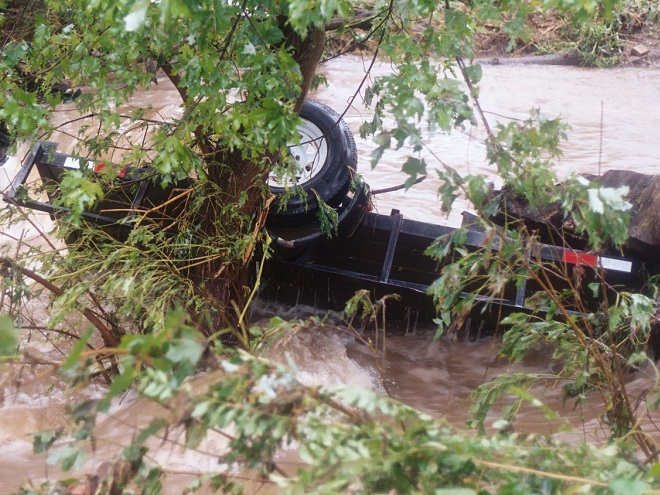
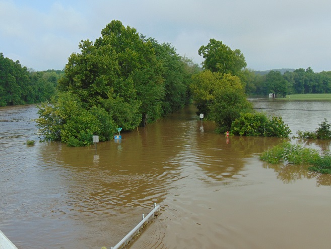
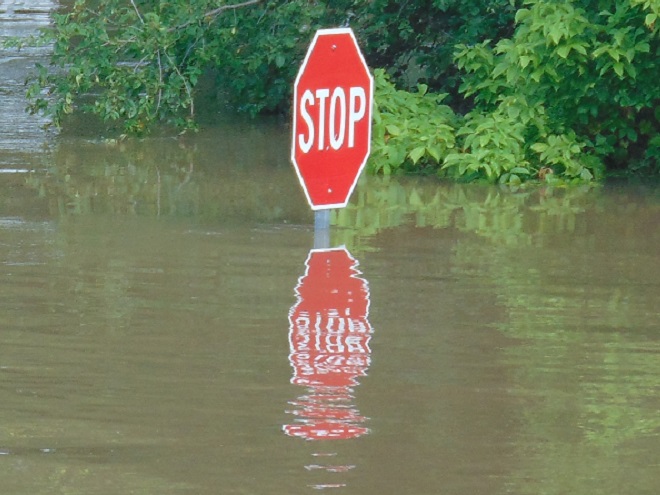
It was a routine occurrence in many communities along tributaries of the lower Susquehanna River during the most recent two months. The rain falls like it’s never going to stop—inches an hour. Soon there is flash flooding along creeks and streams. Roads are quickly inundated. Inevitably, there are motorists caught in the rising waters and emergency crews are summoned to retrieve the victims. When the action settles, sets of saw horses are brought to the scene to barricade the road until waters recede. At certain flood-prone locations, these events are repeated time and again. The police, fire, and Emergency Medical Services crews seem to visit them during every torrential storm—rain, rescue, rinse, and repeat.
We treat our local streams and creeks like open sewers. Think about it. We don’t want rainwater accumulating on our properties. We pipe it away and grade the field, lawn, and pavement to roll it into the neighbor’s lot or into the street—or directly into the waterway. It drops upon us as pure water and we instantly pollute it. It’s a method of diluting all the junk we’ve spread out in its path since the last time it rained. A thunderstorm is the big flush. We don’t seem too concerned about the litter, fertilizer, pesticides, motor fluids, and other consumer waste it takes along with it. Out of sight, out of mind.
Failure to retain and infiltrate stormwater to recharge aquifers can later result in well failures and reduced base flow in streams. (Conoy Creek’s dry streambed in June, 2007)
Perhaps our lack of respect for streams and creeks is the source of our complete ignorance of the function of floodplains.
Floodplains are formed over time as hydraulic forces erode bedrock and soils surrounding a stream to create adequate space to pass flood waters. As floodplains mature they become large enough to reduce flood water velocity and erosion energy. They then function to retain, infiltrate, and evaporate the surplus water from flood events. Microorganisms, plants, and other life forms found in floodplain wetlands, forests, and grasslands purify the water and break down naturally-occurring organic matter. Floodplains are the shock-absorber between us and our waterways. And they’re our largest water treatment facilities.
Why is it then, that whenever a floodplain floods, we seem motivated to do something to fix this error of nature? Man can’t help himself. He has a compulsion to fill the floodplain with any contrivance he can come up with. We dump, pile, fill, pave, pour, form, and build, then build some more. At some point, someone notices a stream in the midst of our new creation. Now it’s polluted and whenever it storms, the darn thing floods into our stuff—worse than ever before. So the project is crowned by another round of dumping, forming, pouring, and building to channelize the stream. Done! Now let’s move all our stuff into our new habitable space.
Natural Floodplain- Over a period of hundreds or thousands of years, the stream (dark blue) has established a natural floodplain including wetlands and forest. In this example, buildings and infrastructure are located outside the zone inundated by high water (light blue) allowing the floodplain to function as an effective water-absorbing buffer.Impaired Floodplain- Here the natural floodplain has been filled for building (left) and paved for recreation area parking (right). The stream has been channelized. Flood water (light blue) displaced by these alterations is likely to inundate areas not previously impacted by similar events. Additionally, the interference with natural flow will create new erosion points that could seriously damage older infrastructure and properties.
The majority of the towns in the lower Susquehanna valley with streams passing through them have impaired floodplains. In many, the older sections of the town are built on filled floodplain. Some new subdivisions highlight streamside lawns as a sales feature—plenty of room for stockpiling your accoutrements of suburban life. And yes, some new homes are still being built in floodplains.
When high water comes, it drags tons of debris with it. The limbs, leaves, twigs, and trees are broken down by natural processes over time. Nature has mechanisms to quickly cope with these organics. Man’s consumer rubbish is another matter. As the plant material decays, the embedded man-made items, particularly metals, treated lumber, plastics, Styrofoam, and glass, become more evident as an ever-accumulating “garbage soil” in the natural floodplains downstream of these impaired areas. With each storm, some of this mess floats away again to move ever closer to Chesapeake Bay and the Atlantic. Are you following me? That’s our junk from the curb, lawn, highway, or parking lot bobbing around in the world’s oceans.
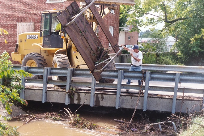
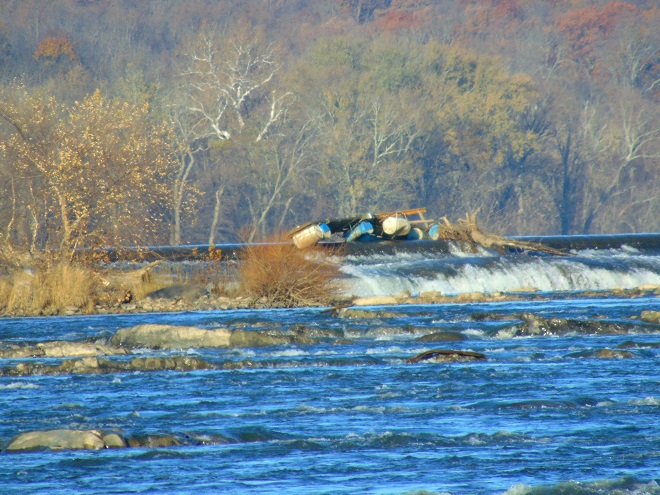
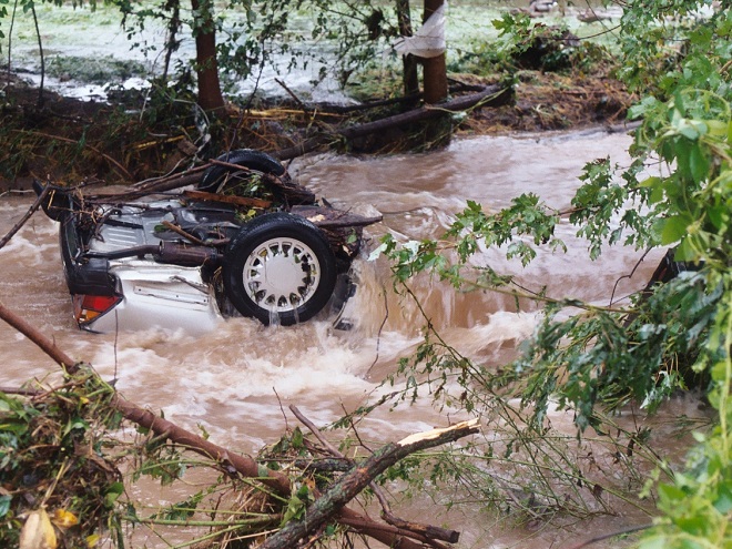
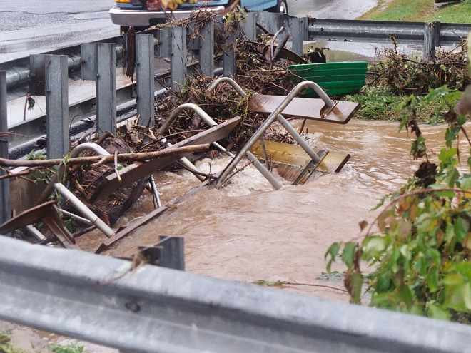
A shed, mobile home, or house can be inundated or swept away during a flood. Everything inside (household chemicals, gasoline, fuel oil, pesticides, insulation, all those plastics, etc.) instantly pollutes the water. Many communities that rely on the Susquehanna River for drinking water are immediately impacted, including Lancaster, PA and Baltimore, MD. This dumpster was swept away from a parking lot in a floodplain. It rolled in the current, chipping away at the bridge before spilling the rubbish into the muddy water. After the flood receded, the dumpster was found a mile downstream. Its contents are still out there somewhere.Floodplains along the lower Susquehanna River are blanketed with a layer of flotsam that settles in place as high water recedes. These fresh piles can be several feet deep and stretch for miles. Nature decomposes the organic twigs and driftwood to build soil-enriching humus. However, the plastics and other man-made materials that do not readily decay or do not float away toward the sea during the next flood are incorporated into the alluvium and humus creating a “garbage soil”. Over time, the action of abrasives in the soil will grind small particles of plastics from the larger pieces. These tiny plastics can become suspended in the water column each time the river floods. What will be the long-term impact of this type of pollution?Anything can be swept away by the powerful hydraulic forces of flowing water. Large objects like this utility trailer can block passages through bridges and escalate flooding problems.The cost of removing debris often falls upon local government and is shared by taxpayers.Here, a junked boat dock is snagged on the crest of the York Haven Dam at Conewago Falls. Rising water eventually carried it over the dam and into the falls where it broke up. This and tons of other junk are often removed downstream at the Safe Harbor Dam to prevent damage to turbine equipment. During periods of high water, the utility hauls debris by the truck-load to the local waste authority for disposal. For the owners of garbage like this dock, it’s gone and it’s somebody else’s problem now.Motor vehicles found after floating away from parking areas in floodplains can create a dangerous dilemma for police, fire, and E.M.S. personnel, particularly when no one witnesses the event. Was someone driving this car or was it vacant when it was swept downstream? Should crews be put at risk to locate possible victims?
Beginning in 1968, participating municipalities, in exchange for having coverage provided to their qualified residents under the National Flood Insurance Program, were required to adopt and enforce a floodplain management ordinance. The program was intended to reduce flood damage and provide flood assistance funded with premiums paid by potential victims. The program now operates with a debt incurred during severe hurricanes. Occurrences of repetitive damage claims and accusations that the program provides an incentive for rebuilding in floodplains have made the National Flood Insurance Program controversial.
In the Lower Susquehanna River Watershed there are municipalities that still permit new construction in floodplains. Others are quite proactive at eliminating new construction in flood-prone zones, and some are working to have buildings removed that are subjected to repeated flooding.
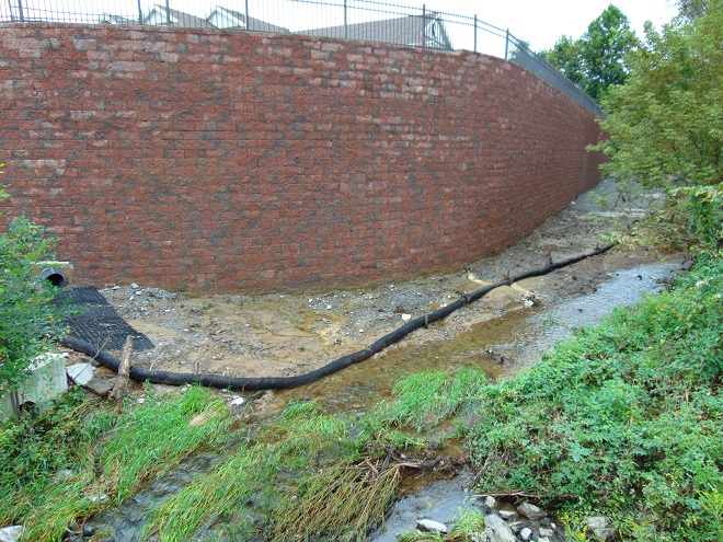
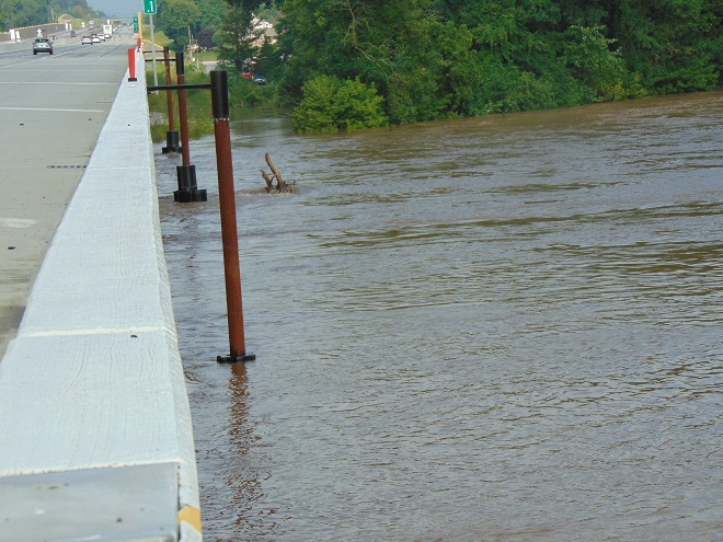
Another Wall— Here’s an example of greed by the owner, engineer, and municipality… placing their financial interests first. The entire floodplain on the north side of this stream was filled, then the wall was erected to contain the material. A financial institution’s office and parking lot was constructed atop the mound. This project has channelized the stream and completely displaced half of the floodplain to a height of 15 to 20 feet. Constructed less than five years ago, the wall failed already and has just been totally reconstructed. The photo reveals how recent flooding has begun a new erosion regime where energy is focused along the base of the wall. Impairment of a floodplain to this degree can lead to flooding upstream of the site and erosion damage to neighboring infrastructure including roads and bridges.The floodplain along this segment of the lower Swatara Creek in Londonderry Township, Dauphin County is free to flood. Ordinances prohibit new construction here and 14 older houses that repeatedly flooded were purchased, dismantled, and removed using funding from the Federal Emergency Management Agency (F.E.M.A). A riparian buffer was planted and some wetland restorations were incorporated into stormwater management installations along the local highways. When the waters of the Swatara rise, the local municipality closes the roads into the floodplain. Nobody lives or works there anymore, so no one has any reason to enter. There’s no need to rescue stubborn residents who refused advice to evacuate. Sightseers can park and stand on the hill behind the barricades and take all the photographs they like.A new Pennsylvania Turnpike bridge across Swatara Creek features wide passage for the stream below. Water flowing in the floodplain can pass under the bridge without being channelized toward the path where the stream normally flows in the center. The black asterisk-shaped floats spin on the poles to help deflect debris away from the bridge piers. (flood crest on July 26, 2018)People are curious when a waterway floods and they want to see it for themselves. Wouldn’t it be wise to anticipate this demand for access by being ready to accommodate these citizens safely? Isn’t a parking lot, picnic area, or manicured park safer and more usable when overlooking the floodplain as opposed to being located in it? Wouldn’t it be a more prudent long-term investment, both financially and ecologically, to develop these improvements on higher ground outside of flood zones?Now would be a good time to stop the new construction and the rebuilding in floodplains. Aren’t the risks posed to human life, water quality, essential infrastructure, private property, and ecosystems too great to continue?Isn’t it time to put up the white flag and surrender the floodplains to the floods? That’s why they’re there. Floodplains are for flooding.
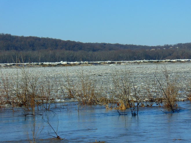
Two days ago, widespread rain fell intermittently through the day and steadily into the night in the Susquehanna drainage basin. The temperature was sixty degrees, climbing out of a three-week-long spell of sub-freezing cold in a dramatic way. Above the ice-covered river, a very localized fog swirled in the southerly breezes.
By yesterday, the rain had ended as light snow and a stiff wind from the northwest brought sub-freezing air back to the region. Though less than an inch of rain fell during this event, much of it drained to waterways from frozen or saturated ground. Streams throughout the watershed are being pushed clear of ice as minor flooding lifts and breaks the solid sheets into floating chunks.
Today, as their high flows recede, the smaller creeks and runs are beginning to freeze once again. On larger streams, ice is still exiting with the cresting flows and entering the rising river.
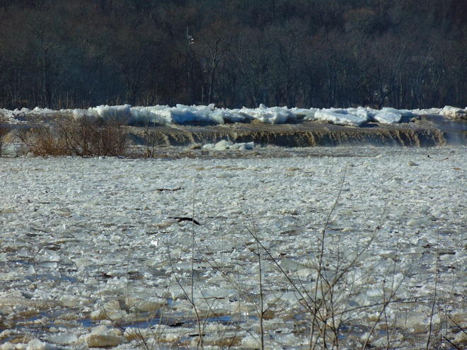
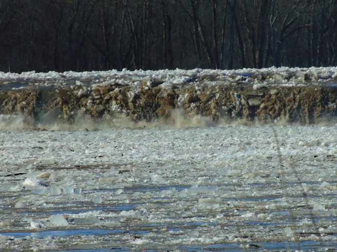
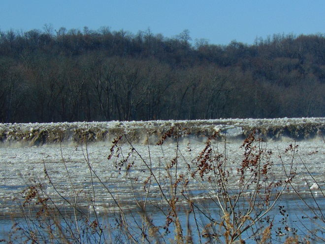
Ice chunks on Swatara Creek merge into a dense flow of ice on the river in the distance. Swatara Creek is the largest tributary to enter the Susquehanna in the Gettysburg Basin. The risk of an ice jam impounding the Swatara here at its mouth is lessened because rising water on the river has lifted and broken the ice pack to keep it moving without serious impingement by submerged obstacles. Immovable ice jams on the river can easily block the outflow from tributaries, resulting in catastrophic flooding along these streams.Fast-moving flows of jagged ice race toward Three Mile Island and Conewago Falls. The rising water began relieving the compression of ice along the shoreline during the mid-morning. Here on the river just downstream of the mouth of Swatara Creek, ice-free openings allowed near-shore piles to separate and begin floating away after 10:30 A.M. E.S.T. Moving masses of ice created loud rumbles, sounding like a distant thunderstorm.Ice being pushed and heaved over the crest of the York Haven Dam at Conewago Falls due to compression and rising water levels.Enormous chunks of ice being forced up and over the York Haven Dam into Conewago Falls and the Pothole Rocks below.Ice scours Conewago Falls, as it has for thousands of years.The action of ice and suspended abrasives has carved the York Haven Diabase boulders and bedrock of Conewago Falls into the amazing Pothole Rocks.The roaring torrents of ice-choked water will clear some of the woody growth from the Riverine Grasslands of Conewago Falls.To the right of center in this image, a motorcar-sized chunk of ice tumbles over the dam and crashes into the Pothole Rocks. It was one of thousands of similar tree-and-shrub-clearing projectiles to go through the falls today.
The events of today provide a superb snapshot of how Conewago Falls, particularly the Diabase Pothole Rocks, became such a unique place, thousands of years in the making. Ice and flood events of varying intensity, duration, and composition have sculpted these geomorphologic features and contributed to the creation of the specialized plant and animal communities we find there. Their periodic occurrence is essential to maintaining the uncommon habitats in which these communities thrive.
Fish Crows (Corvus ossifragus) gather along the flooding river shoreline. Soon there’ll be plenty of rubbish to pick through, some carrion maybe, or even a displaced aquatic creature or two to snack upon.