Some comparative attributes of unspoiled lotic vs. lentic freshwater ecosystems. Low-gradient (slow-moving) lotic waters often create, and remain connected to, accompanying riverine wetlands (a lentic freshwater ecosystem). These swamps, marshes, and ditches absorb, purify, and infiltrate flood waters while supporting a diverse number of plant and animal species.
We frequently perceive all waterfowl migration to be synchronized with the conspicuous movements of familiar species like Snow Geese, Tundra Swans, and Canada Geese—big flights coming south in October and November, then a return to the north in late February and March. And we’re all quite aware of the occurrence of large gatherings of some of these migrants while they make stopovers on some of our largest lentic (still) waters—the man-made lakes and reservoirs created by damming local streams. But did you know that there are populations of colorful waterfowl with dynamic migrations that extend throughout the winter and early spring with movements that are often continuous. Under favorable conditions, these birds favor the lotic (flowing) waters of the river and its larger tributaries as they transit the lower Susquehanna valley. That’s because unpolluted lotic freshwater ecosystems support a greater diversity of plants and animals than lentic waters, and therefore offer more opportunities for hungry migrating waterfowl to find food. Let’s have a look at some of the species that visit the river during their seasonal journeys…
While the urge to head south in the autumn is largely stimulated by the shortening of the photoperiod, it is the presence of ice, particularly on glacial lakes throughout the lands to the north of the lower Susquehanna River basin, that pushes many diving ducks to finally make their way south toward the guarantee of open-water feeding areas along the coast. This movement may occur at anytime between November and late February or, as we have seen during some of the mild winters of recent decades, it may scarcely be noticed at all.Common Mergansers often lead they way when it comes to migratory diving ducks. They regularly move south in conspicuous numbers by late November and December and are regularly pushing north as soon as the ice begins to melt. During a typical year, it is not unusual for some populations of these large diving birds to remain north of us during the winter. Then, in the days after a sudden rush of frigid polar air, an appreciable increase in ice cover will force a mid-winter movement of birds down the Susquehanna.Temperatures in lotic fresh waters vary over the length of the stream or river. They are largely determined by the collective impact of the numerous sources of heat flux depicted in this graphic. (Environmental Protection Agency image)Buffleheads begin passing through the lower Susquehanna region in Novemeber on their way to coastal saltwater bays for the winter. Lingering populations feed by diving in the river’s pools and riffles for benthic invertebrates including snails and insect larvae. Lesser quantities of aquatic plant matter supplement their diet.Many Common Goldeneyes will remain on shallow, ice-free waters of the northern lakes and rivers sculpted by the most recent glacial event, but only until they are forced south into and through the lower Susquehanna valley by the encroachment of freezing conditions. On the river, they are among the dozen or so species of diving ducks we see visiting or passing through during the typical late fall and early river.
During their visits to the lotic (also known as riverine) fresh waters of the Susquehanna and its largest tributaries, benthic-feeding waterfowl make short dives to take advantage of the plants, small fish, invertebrates, and other food sources inhabiting the stream bottom in the riffles and pools of the free-flowing waterway. Substrates, listed here by size (in descending order), along with other parameters influenced by this zonation determine the variety and abundance of the forage available to migrating waterfowl and other consumers. Ice or high water and poor visibility due to flooding can render the riffles and pools of the channel unusable for feeding. The birds must then choose to either linger and rest without feeding or leave the lotic freshwater habitat to seek sustenance. During a flood, this may require relocation to a nearby lentic (still) body of fresh water such as a lake or reservoir. The presence of ice will almost invariably force the birds to fly on to the Atlantic Coastal Plain and the tidal waters of its bays and estuaries.Hooded Mergansers are one of the few species of diving ducks likely to utilize flooded shoreline timber and riverine (fluvial) wetlands as refuge from high water on Susquehanna.A Pied-billed Grebe and a pair of Canvasbacks on an ice-free stretch of the lower Susquehanna in mid-winter feed and loaf in a riffle-flanked pool where a large mat of American Eelgrass, a submerged aquatic plant also known as Tapegrass or Wild Celery, grows during the summer. The vast mosaic of riffles and pools in a river this size offers tremendous opportunities for a diverse array of aquatic species to find their niche wherein they can survive and flourish.The presence of ice forces Buffleheads and other diving ducks to gather in turbulent open water, often below a riffle or dam. Another alternative is to continue on toward the salty bays and estuaries of the coast. High water may push these birds into the shallows among the flooded woods to feed, but they seldom utilize heavily forested riparian wetlands as a refuge due to their need for a running start to get airborne.
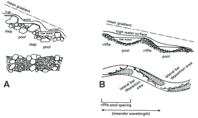
Riffle and Pool Characteristics of High Gradient (A) and Low Gradient (B) Streams. This graphic illustrates the change in deposition characteristics of a stream or river as its gradient decreases. A high-gradient stream (A) has a rapid velocity, often forms falls, and tends to carry away a high volume of all but the largest of particles of potential substrates as they erode from the surrounding landscape. On a low-gradient stream, the loss in water velocity reduces the water column’s ability to transport even the smallest of substrate particles. Deposition of this gravel, sand, silt, and clay forms lateral bars that over time create the familiar meandering path of a naturally flowing lowland stream. (National Park Service image)Benthic substrates in lotic freshwater pools and riffles support an abundance of life forms ranging from colorful diatoms on rocks and cobble, to invertebrates including snails and insect larvae, to fishes like this young Channel Catfish. Free of accumulations of sediment, this river bottom not only provides habitat for a healthy fishery, it facilitates the bidirectional exchange of water between the Susquehanna and its underlying aquifer.On the lower Susquehanna, populations of young Quillback suckers are found almost exclusively in clear, high-gradient pools.The Harlequin Duck winters along the rocky shores and man-made jetties of the Atlantic coast. In summer, they nest on fast-moving, headwater streams well to our north. Very rare on the Susquehanna, this is the first of two individuals found during March and April of 2025. It was observed feeding in the swift waters of the high-gradient riffles and pools where the river cuts through Blue Mountain north of Harrisburg. During previous weeks, Harlequin Ducks were being seen along the coast as far south as the mouth of the Chesapeake at Cape Charles, Virginia. It’s very possible that some of these birds traveled north through the bay area and up the Susquehanna on their way north.
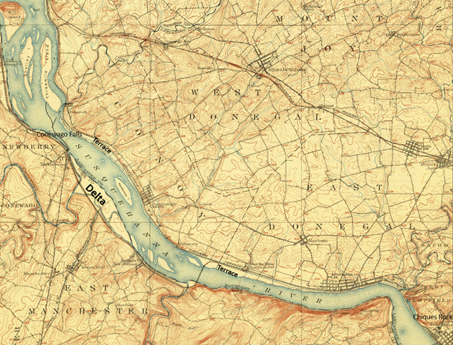
Fluvial Geomorphology of a Stream. Many of the Susquehanna’s tributaries pass through each of these three erosional zones. Along the way, they carry out the process of breaking down the mountains formed by the Allegheny orogeny, the collision of North America and Africa that created the supercontinent Pangea about 325 to 260 million years ago (during portions of both the Carboniferous and Permian periods). Today’s main stem of the lower Susquehanna passes through a transfer zone (Zone 2), carrying eroded materials to a depositional zone (Zone 3) located within the ancient Susquehanna canyon stretching from Havre de Grace, Maryland, to Norfolk Canyon on the edge of the continental shelf. Within this zone, more than a 10,000-year accumulation of post-glacial sediments lies submerged by the rising waters of the Atlantic Ocean and Chesapeake Bay. Although the present-day lower Susquehanna is largely a transfer zone, some deposition occurs along low-gradient segments of the river, particularly where its course parallels the watershed’s ridges both above and below the high-gradient rapids where its path has eroded passage through the highlands. (National Park Service image)Although the present-day lower Susquehanna is largely a transfer zone, some deposition occurs along low-gradient segments of the river, particularly where its course parallels the watershed’s ridges both above and below the high-gradient rapids where its path continues to erode passage through the bedrock. On this 1908 map of the Susquehanna at Conewago Falls, alluvial terraces of gravel, sand, silt, and clay can readily been seen as pale areas nearly lacking brown contour lines along the shorelines and islands of the river. Deposits within most of these terraces date back to the melt period following the most recent glacial event and beyond. The delta shown at the mouth of Conewago Creek (west) includes massive volumes of material deposited by both the creek and the river. This delta is currently known as Brunner Island, much of it developed as the site of a coal/gas-fired electric generating station. Terrace deposits along the Susquehanna’s shorelines created extensive perched marshes and swamps (wooded marshes) fed by rains, high river water, small streams, and springs, the latter often seeping from the base of the rocky escarpments carved by the ancient Susquehanna and defining the present-day inland border of the floodplain. We call these sites “Alluvial Terrace Wetlands”. Few of these critical components of river morphology survive. Those not drained for farmland were obliterated by urbanization and canal, railroad, and highway construction. (United States Geological Survey base image: Middletown, PA, quadrangle, 1908)Water Willow is a familiar emergent plant that colonizes lateral bars and other alluvial deposits in low-gradient segments of the Susquehanna.The fine roots of Water Willow collect sediment and absorb nutrients while creating dense cover for young fish and numerous species of invertebrates including the Virginian River Horn Snails seen here.
Prior to the nineteenth century, the low-gradient flow regime of the river both above and below the riffles at Chiques Rock (lower right on map) created prime wildlife habitat. The natural accumulations of nutrients and substrates carried into and through the lotic waterway’s pools and riffles were cycled into an ideal growing medium for extensive mats of American Eelgrass and other aquatic plants. This underwater forest hosted a seemingly endless abundance of invertebrates and fishes (both resident and migratory)—supporting a variety of consumer species including various populations of humans. But soon after the mass clearing of much of the watershed’s land for farming and lumber, the mill ponds created by dams constructed on streams to power saw and grain mills became brimful with sediments eroded from the unprotected ground. During storm events, torrents of these sediments then flowed full bore toward the Susquehanna, and began accumulating in the low-gradient segments of the river.
Sediments left behind after the removal of mill dams are known as legacy sediments. They disconnect the stream from its historic floodplain and riverine (fluvial) wetlands, thus intensifying the impact of high water in the surrounding landscape. As these nutrient-charged deposits wash away, they become a source of pollution in the waters of the Susquehanna and Chesapeake.A mat of American Eelgrass growing in the flowing waters of the Susquehanna below Conewago Falls. Eelgrass and other submerged aquatic plants provide essential habitat for a wide variety of small fish and invertebrates while also consuming nutrients deposited in the cobble, gravel, and sand substrate of the river’s pools. Excess quantities of smaller particles of silt and clay can clog the substrate and thus inhibit the hyporheic exchange of water between the stream channel and the underlying aquifer, often diminishing the biomass and diversity of organisms inhabiting this benthic habitat. Buried in these life-choking sediments, the river bottom becomes inhospitable to growth of submerged aquatics including eelgrass.This low-gradient stretch of the Susquehanna at Marietta flows parallel to the Chickies Quartzite “Hellam Hills” before making a sharp right turn to punch through the ridge as a series of rapids at Chiques Rock. Formerly a fully functional lotic ecosystem and a paradise for migrating waterfowl, this river segment is now impaired by accumulations of nutrient-laden sediments from agricultural and urban runoff.Nutrient and sediment-loaded flood waters roar across the diabase boulders at the York Haven Dam and Conewago Falls, a high-gradient segment of the Susquehanna.They continue past Brunner Island (left power plant stacks) and through Haldeman Riffles and the Shocks Mills Railroad Bridge……into the stretch of river known as the “Marietta broads” along the base of the Chickies Quartzite “Hellam Hills”. The low stream gradient here produces a slower current and increased deposition of sediments.As the flood surges through the riffle and pool complex at Chiques Rock, the high stream gradient maintains a velocity in the water column sufficient to keep additional sediments in suspension until they reach the low-gradient river segment just downstream at Washington Boro, site of a naturally occurring lateral bar area known as the Conejohela Flats. These bars now lie within the man-made depositional zone known as “Lake Clarke”. Created nearly a century ago by construction of the Safe Harbor Dam, this impoundment is accumulating astounding volumes of nutrient-loaded sediments that continue to encapsulate the flats within a stream-impairing delta.Anytime from November to April on the lower Susquehanna, a group of Redheads, Canvasbacks (3 birds to right of the middle of the picture), and a Horned Grebe (lower left) is a welcome sight in a riverine pool known to have a summertime growth of American Eelgrass. Noted Dr. Herbert Beck in 1924 when describing the Canvasback, “Like all ducks, …, it stops to feed within the county (Lancaster) less frequently than formerly, principally because the vast beds of wild celery which existed earlier on broads of the Susquehanna, as at Marietta and Washington Borough, have now been almost entirely wiped out by sedimentation of culm. Prior to 1875 the four or five square miles of quiet water off Marietta were often as abundantly spread with wild fowl as the Susquehanna Flats are now. Sometimes there were as many as 500,000 ducks of various kinds on the Marietta broad at one time.”Today, seeing just dozens of Aythya genus ducks (Redheads, Canvasbacks, scaup) on the lower Susquehanna is a notable event. If they happen to be forced down by inclement weather while migrating through, you might get lucky enough to see several hundred.While the recovery of eelgrass/wild celery beds on the Susquehanna is trivial in scale and offers little support for numbers of waterfowl to return to historic levels, restorations on the upper Chesapeake in the vicinity of the Susquehanna Flats between Havre de Grace and Aberdeen Proving Grounds may have helped refuel a gathering of mostly Aythya genus ducks during the final days of February. This mass of ducks, many of which were forced south from the frozen Great Lakes during the previous weeks (some by way of the ice-choked Susquehanna) were apparently making an abrupt turn to make their way back north. Their stay was brief, but estimates by local birders put their numbers as high as one half million. The vast majority of the concentration consisted of Aythya species: Redheads, Canvasbacks, Ring-necked Ducks, and both Lesser and Greater Scaup. It probably included a mix of birds including both northbound migrants from further down the coast and the aforementioned refugees that had just arrived to pay a quick visit while escaping the late-season ice before turning around.During the past two centuries, as food supplies in the Susquehanna grew increasingly compromised for benthic feeders like these Lesser Scaup and other diving ducks, a change in distribution was necessary for survival.As individual species, Lesser Scaup and other waterfowl that fail to adapt to natural or man-made changes in their habitats and food supplies may see their overall global numbers falter.
Despite being located in the transfer zone, the lower Susquehanna has become a significant depositional zone along much of its length, mostly courtesy of the placement of sediment-trapping man-made dams.
Following construction of the mill dams and ponds on nearly every mile of the lower Susquehanna’s low-gradient tributary streams, enterprising parties moved on to the river. The first significant spans were constructed using wide timber cribs filled with large rock. They were placed to create water deep enough to allow canal boats to cross the Susquehanna at both Clark’s Ferry at the mouth of the Juniata River in Dauphin County and at Columbia/Wrightsville. These dams also diverted water into the newly excavated canals—the Pennsylvania Eastern Division Canal (completed in 1833) which followed the river’s east shore from Clark’s Ferry to Columbia, and the Susquehanna and Tidewater Canal (completed in 1840) along the west shore from Wrightsville to Havre de Grace, Maryland. Placement of these sediment-trapping man-made dams began a process of converting vast mileage of the lower Susquehanna from a transfer zone into a deposition zone. In addition, layout of the canals and locks followed the contours along the base of the riverside ridges, seriously altering most of the alluvial terrace wetlands that the river had created as a feature of its floodplain during the post-glacial period.
Construction of the canal dams was just the beginning. During the twentieth century, more massive dams would be added to the main stem of the river for hydroelectric energy production at York Haven, Safe Harbor, Holtwood, and Conowingo. Upon their completion, the days of unassisted anadromous fish migrations were over. On both the river and its tributaries, smaller dams including dangerous low-head dams maintain water levels for boating and recreation. They too create current-diminishing, pseudo-lentic waters that blanket the lotic riffle and pool substrates with polluted sediments.
MAN-MADE DAMS TURN LOTIC WATERS INTO UNFLUSHED TOILETS
The construction of dams on the lower Susquehanna has converted vast mileage of the river from a lotic freshwater system into a series of man-made lentic freshwater lakes. These areas have lost their function as a lotic transfer zone and are now a sort of dysfunctional series of depositional zones collecting vast volumes of sediment containing nutrients and other pollutants. Within each impoundment, the reduced velocity of the river causes it to drop suspended sand first, then the finer particles of silt and clay closer to the dam. The flow regime of riffles and pools is lost and the hyporheic zone that exchanges water between the river and the underlying aquifer is clogged. These impaired segments of river become ripe for eutrophication: algal blooms followed by die offs that can lead to a fatal reduction of dissolved oxygen in the water column.Deposits of lateral bars of sediment in low-gradient segments of the Susquehanna can create shallow water feeding habitat for puddle/dabbling ducks like these Gadwall. Where sediment pollution is severe, benthic foods in these areas often consist mostly of invertebrates and plant matter deposited by the current, the buried substrates devoid of a functioning ecosystem and the waters subject to eutrophication.Common Goldeneyes on a patch of open water on an otherwise ice-covered “Lake Clarke”, the impoundment created by Safe Harbor Dam. While they may find this spot advantageous for loafing, the food supply over the sediment-buried substrate will be limited.By the end of the twentieth century, accumulations of polluted sediments behind lower Susquehanna dams were nearing capacity. There is no working plan to attenuate the massive release of these pollutants that may be triggered by a catastrophic flood. The effort to reduce nutrient and sediment runoff remains the focus so that new loading is kept to a minimum and won’t add to the capacity problems at the dams or continue downriver to the Chesapeake at full strength when the dams are full. Alleviating the sediment aggregation problem within the river’s impoundments is a tall order and a dilemma not easily solved. (United States Geological Survey image)Common Mergansers will feed where benthic substrate supports the small fish and invertebrates they prefer. They will, however, gather in extraordinary numbers on the “lakes” created by riverine dams. Though they can only feed on what floats in with the current, hundreds or sometimes thousands of Common Mergansers will concentrate on “Conowingo Pond” during the late fall or early winter. There, safety in numbers gives them some guarantee of protection against the multitudes of eagles that simultaneously frequent the vicinity. Another advantage of staging on “Conowingo Pond” is its close proximity to favorable feeding areas on upper Chesapeake Bay and stretches of the Susquehanna where lotic riffles and pools offer abundant opportunities below the river’s dams.Fortunately for everything else living in the benthos, Common Mergansers are big enough to devour invasive, non-native Rusty Crayfish when they find them in our lotic waterways.
TIME TO CLEAN UP OUR ACT
WHERE DOES YOUR STORMWATER GO?
Channelized Urban/Suburban Streams Function as Sewers. They have no attached lowlands or floodplains to absorb, purify, and infiltrate runoff from rain events. Pollutants including litter, pet waste, lawn chemicals, tire-wear particles, hazardous fluids, and sometimes untreated human excrement flush unchecked from the municipal storm drainage system into the waterway. Thermal shock from summer downpours washing across sun-heated pavements can kill temperature sensitive fishes and other aquatic life. Nutrient and sediment loads from these impaired tributaries later accumulate downstream in low-gradient segments of the Susquehanna, turning the river into an open-air cesspool. Aggressively working to implement projects that eliminate these sources of pollution are the only effective way to keep the problem from getting worse. Making things better requires a lot more dedication and effort. (United States Geological Survey image by Frank Ippolito)
RIPARIAN BUFFERS MAKE A DIFFERENCE…WIDER IS BETTER
To sequester sediment and cycle nutrients (primarily nitrogen and phosphorus) contained in farm runoff, the U.S.D.A. recommends installing riparian buffers between streams and lands used for grazing and raising crops. To protect pollinating species including bees and butterflies from pesticide drift and eroding soils rich in fertilizers, they further recommend installing a stand of wind-pollinating plants such as conifers, oaks, and birches between the field and streamside plantings. These same conservation practices improve water quality and wildlife habitat on waterways located in residential and commercial areas as well. (United States Department of Agriculture image, click to enlarge)
FLOODPLAIN RESTORATION
Regardless OF HOW LONG YOU’VE BEEN CONDITIONED TO THINK OTHERWISE, THIS IS A DYSFUNCTIONAL, POLLUTED CREEK—AND IT NEEDS HELP
A channelized low-gradient stream eroding a path through deposits of legacy sediments displaces flood waters into previously unaffected areas and provides a continuing source of nutrient and sediment pollution during storm events. These impaired waters have a diminished capacity for supporting aquatic life including fishes.
RESTORED TO ITS HISTORIC FUNCTIONS
On an adjacent segment of the same creek, this legacy sediment removal project restored a braided meandering channel and connected it to its newly liberated, historic floodplain. In just their second year, the fluvial wetlands are effectively absorbing stormwater and sequestering nutrients as an attached component of the stream’s riffle and pool complex. During our visit earlier this week, we found American Toads, Northern Leopard Frogs (Lithobates pipiens), and Northern Spring Peepers breeding here. It’s just as Castor canadensis would have it!
“STOP HEMMING AND HAWING AROUND ALREADY”
“HEY COWBOY, HOW ‘BOUT GETTIN’ THEM FILTHY LITTLE DOGIES OUTTA DAT CRICK?”
Here’s a polluted stream in a pasture with grazing livestock. The site is a former mill pond within which the creek eroded a channel following removal of the dam. The animals defecate and urinate where access to water is gained at a broken down embankment of the nutrient-loaded legacy sediments deposited in the pond more than a century ago. It’s a haphazard form of animal husbandry and a reminder that all it takes is just one stubborn jackass to foul up the whole waterway.
DIRECT SOURCES OF NITROGEN (AMMONIA) POLLUTION IN STREAMS
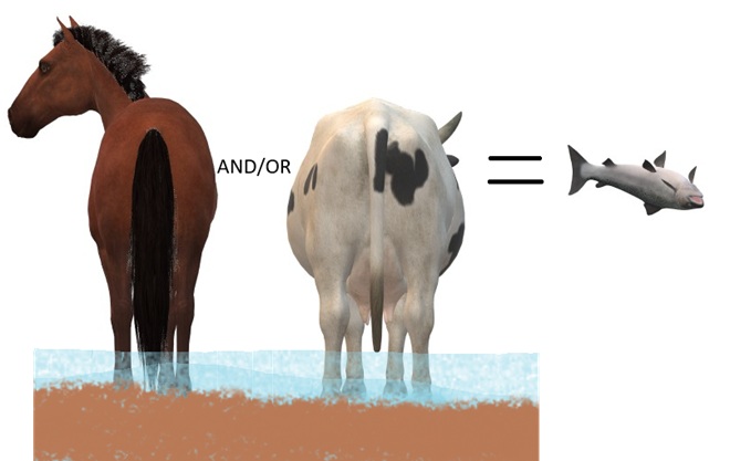
DID YOU KNOW that a dairy cow produces about 80 pounds of waste (excrement and urine) every day?
DID YOU KNOW that a horse produces about 50 pounds of waste (excrement and urine) every day?
DID YOU KNOW that a human produces about 3 to 4 pounds of waste (excrement and urine) every day? The exceptions, of course, are those who continue to insist that raising farm animals in and alongside a body of water is okey-doke—a harmless practice. These individuals tend to retain the former constituent of human waste and are thus full of it.
“ATTABOY TEX, THAT’S MORE LIKE IT!”
Now that’s better. Legacy sediments have been removed to reconnect the stream to its floodplain. A livestock crossing and exclusion fencing has been installed, and a nutrient-consuming riparian buffer has been planted. This creek segment’s pollution woes have been mitigated. Do you have a neighbor needing this type of remedial work on their farm? Have them call your local conservation district office for advice. Some programs include financial assistance covering the costs of installation as well as monetary incentives for helping to clean up the water.
AND FINALLY
WHEN IT COMES TO BUILDING DAMS ON LOTIC FRESH WATERS…
…LEAVE IT TO THE BEAVERS
North American Beavers (Castor canadensis) create habitats that connect the riffle and pool regime of a low-gradient stream to a surrounding fluvial wetland that retains sediments, cycles nutrients, and provides essential habitat for hundreds of plant and animal species. Floodplains are for flooding. And if a beaver floods an area, you can be guaranteed that it was already part of a floodplain. You see, beavers don’t encroach upon humans, it’s humans doing the encroaching upon beavers. (National Park Service image)
MAD HATTERS
DID YOU KNOW that even before the landscape was cleared for farms and a supply of timber, and before mill dams on local creeks began accumulating soil runoff from the consequently barren hillsides, all the North American Beavers, the keystone species of lower Susquehanna stream ecology, were killed and sold to make hats? It’s no wonder things are fubar!
COMING SOON…
Horned Grebes are regular migrants and sometimes winter residents on ice-free stretches of the lower Susquehanna. They spend their time plying the benthic substrate of the river’s clear riffles and pools for a variety of invertebrates and small fish. Look for them moving north in coming days sporting this beautiful breeding plumage.April and early May are prime time for observing Common Loons on the Susquehanna as they undertake a journey from the Atlantic surf where they spent the winter to nesting sites on northern lakes. For this migrant in breeding plumage, clear water for sighting plenty of benthic life in the river’s riffles and pools assures a successful dive in search of energy-replenishing forage.
Just in time for the Flag Day/Father’s Day weekend, the Jordanella floridae we raise here at susquehannawildlife.net headquarters to help control hair algae in our planted aquaria are beginning to spawn.
A male Jordanella floridae displaying for a prospective female mate. A receptive female will nip the fins of a courting male prompting him to chase her.
In the wild, Jordanella floridae inhabits a variety of vegetated tropical wetlands and backwaters on the Florida peninsula. The species was first described there on Lake Munroe in 1879 by George Brown Goode and Tarleton Hoffman Bean, both of whom spent time working for the Smithsonian National Museum and the United States Fish Commission, the latter a forerunner of the U. S. Fish and Wildlife Service. Goode and Bean collaborated frequently, chronicling the occurrence of freshwater species like J. floridae as well as marine ichthyofauna. In 1896, the duo published Oceanic Ichthyology, an extensive study of pelagic and deep-sea fishes. Each experienced a prestigious career and has had numerous fish species named after him.
Nineteenth-century ichthyologist Tarleton Hoffman Bean (1846-1916) was born along the shores of the Susquehanna below Conewago Falls in Bainbridge, Lancaster County, Pennsylvania. He became a renowned expert on methods of fish culture. (Public Domain image)To the female, the breeding colors of the dominant male Jordanella floridae are irresistible. To us, the star-spangled banner pattern of this native killifish (more specifically a pupfish) justifies the species’ oft-used common name: American Flagfish.After being chased by the male, the female American Flagfish turns pale in color, indicating to the male that she’s ready to mate. The pair then face each other and begin dancing around the nest site which has been prepared by the male. The dance often consists of the female maneuvering so as not to again face in the direction of her partner..To get into spawning position alongside his mate, the male flagfish must commence a series of rolling turns.Once the male is successful and the female is receptive, spawning quickly ensues and the pair swims sideways in a tight circle around the center of the nest site……as the eggs are deposited and fertilized.Female American Flagfish lay fewer than two dozens eggs, so the male must diligently guard the nest from potential outside threats to his progeny including snails, dragonfly nymphs, and other fishes. Periodically, he’ll use his fins to fan a current across the eggs to clear them of debris and assure an exchange of fresh water through the nest.For the male American Flagfish, obsessive patrol of the nest site and care of the eggs continues day and night. The American Flagfish, a dandy that dresses for his role as an All-American Dad.
Visitors stopping by Middle Creek Wildlife Management Area this week found yet another post-breeding wanderer feeding in the shallows of the main lake and adjacent pond along Hopeland Road—a juvenile Little Blue Heron.
The juvenile Little Blue Heron is a white bird resembling an egret during its first year. At about one year of age, it begins molt into a deep blue adult plumage. Young birds are notorious for roaming inland and north from breeding areas along the Atlantic coast and throughout the south. They are a post-breeding wanderer nowhere near as rare as the Limpkin seen at Middle Creek a week ago; a few are found each summer in the Lower Susquehanna River Watershed.
A juvenile Little Blue Heron currently at Middle Creek Wildlife Management Area. Note the yellow legs and pale beak, field marks that help separate this species from the Great Egret and Snowy Egret.
As oft times happens, birders attracted to see one unusual bird find another in the vicinity. So with fall shorebird migration ramping up, the discovery of something out of the ordinary isn’t a total surprise, particularly where habitat is good and people are watching.
A Hudsonian Godwit (Limosa haemastica) has arrived on mudflats at Middle Creek Wildlife Management Area.
The arrival of a Hudsonian Godwit is not an unheard of occurrence in the lower Susquehanna region, but locating one that sticks around and provides abundant viewing opportunities is a rarity. This adult presumably left the species’ breeding areas in Alaska or central/western Canada in recent weeks to begin its southbound movement. Hudsonian Godwits pass through the eastern United States only during the autumn migration, and the majority fly by without being noticed along a route that mostly takes them offshore of the Mid-Atlantic States.
The Hudsonian Godwit (right) at Middle Creek W.M.A. feeding with other migrating shorebirds…a Lesser Yellowlegs (top) and a Least Sandpiper (left).To probe the muddy bottom for invertebrates, Hudsonian Godwits will often wade in deeper water than accompanying species.This godwit seemed to be capturing small snails, presumably the young of the thousands of adult Acute Bladder Snails (Physellla acuta) seen here covering the surface of the mud. This species of air-breathing freshwater snail is tolerant of low levels of dissolved oxygen and is frequently the only mollusk found in polluted waters of the lower Susquehanna valley.For feeding shorebirds, the young snails may be more edible than the adults due to their fragile shells. Small birds like the Least Sandpiper may also be consuming the gelatinous egg masses. In North America, the Acute Bladder Snail was believed to be an introduced species from Europe. DNA testing has now determined that it is actually a native species that was instead transported into Europe from North America early in the nineteenth century or before. Locally, the snails were known as Physella heterostropha and were thought to be native. However, the recent genetic tests have shown Physella heterostropha and Physella integra, a snail first described by Lancaster County naturalist Samuel S. Haldeman, to be synonyms of Physella acuta. Click the “Freshwater Snails” tab at the top of this page to learn more about these mollusks.The Hudsonian Godwit at Middle Creek W.M.A., you may never get a better look!
Mid-summer can be a less than exciting time for those who like to observe wild birds. The songs of spring gradually grow silent as young birds leave the nest and preoccupy their parents with the chore of gathering enough food to satisfy their ballooning appetites. To avoid predators, roving families of many species remain hidden and as inconspicuous as possible while the young birds learn how to find food and handle the dangers of the world.
But all is not lost. There are two opportunities for seeing unique birds during the hot and humid days of July.
First, many shorebirds such as sandpipers, plovers, dowitchers, and godwits begin moving south from breeding grounds in Canada. That’s right, fall migration starts during the first days of summer, right where spring migration left off. The earliest arrivals are primarily birds that for one reason on another (age, weather, food availability) did not nest this year. These individuals will be followed by birds that completed their breeding cycles early or experienced nest failures. Finally, adults and juveniles from successful nests are on their way to the wintering grounds, extending the movement into the months we more traditionally start to associate with fall migration—late August into October.
For those of you who find identifying shorebirds more of a labor than a pleasure, I get it. For you, July can bring a special treat—post-breeding wanderers. Post-breeding wanderers are birds we find roaming in directions other than south during the summer months, after the nesting cycle is complete. This behavior is known as “post-breeding dispersal”. Even though we often have no way of telling for sure that a wandering bird did indeed begin its roving journey after either being a parent or a fledgling during the preceding nesting season, the term post-breeding wanderer still applies. It’s a title based more on a bird sighting and it’s time and place than upon the life cycle of the bird(s) being observed. Post-breeding wanderers are often southern species that show up hundreds of miles outside there usual range, sometimes traveling in groups and lingering in an adopted area until the cooler weather of fall finally prompts them to go back home. Many are birds associated with aquatic habitats such as shores, marshes, and rivers, so water levels and their impact on the birds’ food supplies within their home range may be the motivation for some of these movements. What makes post-breeding wanderers a favorite among many birders is their pop. They are often some of our largest, most colorful, or most sought-after species. Birds such as herons, egrets, ibises, spoonbills, stilts, avocets, terns, and raptors are showy and attract a crowd.
While it’s often impossible to predict exactly which species, if any, will disperse from their typical breeding range in a significant way during a given year, some seem to roam with regularity. Perhaps the most consistent and certainly the earliest post-breeding wanderer to visit our region is the “Florida Bald Eagle”. Bald Eagles nest in “The Sunshine State” beginning in the fall, so by early spring, many of their young are on their own. By mid-spring, many of these eagles begin cruising north, some passing into the lower Susquehanna valley and beyond. Gatherings of dozens of adult Bald Eagles at Conowingo Dam during April and May, while our local adults are nesting and after the wintering birds have gone north, probably include numerous post-breeding wanderers from Florida and other Gulf Coast States.
So this week, what exactly was it that prompted hundreds of birders to travel to Middle Creek Wildlife Management Area from all over the Mid-Atlantic States and from as far away as Colorado?
Birders observing something special at Middle Creek Wildlife Management Area on July 10, 2023.
Was it the majestic Great Blue Herons and playful Killdeer?
Great Blue Heron and a Killdeer.
Was it the colorful Green Herons?
Green Heron
Was it the Great Egrets snapping small fish from the shallows?
Great Egret
Was it the small flocks of shorebirds like these Least Sandpipers beginning to trickle south from Canada?
Least Sandpipers
All very nice, but not the inspiration for traveling hundreds or even thousands of miles to see a bird.
It was the appearance of this very rare post-breeding wanderer…
A Limpkin at Middle Creek Wildlife Management Area in Lancaster County. The Limpkin (Aramus guarauna) is the only surviving member of the family Aramidae.
…Pennsylvania’s first record of a Limpkin, a tropical wading bird native to Florida, the Caribbean Islands, and South America. Many observers visiting Middle Creek Wildlife Management Area had never seen one before, so if they happen to be a “lister”, a birder who keeps a tally of the wild bird species they’ve seen, this Limpkin was a “lifer”.
The Limpkin is an inhabitant of vegetated marshlands where it feeds almost exclusively upon large snails of the family Ampullariidae, including the Florida Applesnail (Pomacea paludosa), the largest native freshwater snail in the United States.
In the United States, the native range of the Limpkin lies within the native range of the Florida Applesnail, shown here in gold. Introduced populations of the snail are shown in brown. (United States Geological Survey Nonindigenous Aquatic Species image)A spectacular nineteenth-century rendition of the Florida Applesnail, including an egg mass, illustrated by Helen E. Lawson in Samuel S. Haldeman’s “Monograph of the Freshwater Univalve Mollusca of the United States”.
Observations of the Limpkin lingering at Middle Creek Wildlife Management Area have revealed a pair of interesting facts. First, in the absence of Florida Applesnails, this particular Limpkin has found a substitute food source, the non-native Chinese Mystery Snail (Cipangopaludina chinensis). And second, Chinese Mystery Snails have recently become established in the lakes, pools, and ponds at the refuge, very likely arriving as stowaways on Spatterdock (Nupharadvena) and/or American Lotus (Nelumbo lutea), native transplants brought in during recent years to improve wetland habitat and process the abundance of nutrients (including waterfowl waste) in the water.
The Chinese Mystery Snail is the largest freshwater snail in the Lower Susquehanna River Watershed. (Vintage 35 mm image)By hitching a ride on aquatic transplants like this Spatterdock, non-native freshwater snails are easily vectored into new areas outside their previous range.Spatterdock, a native species also known as Yellow Pond Lily or Cow Lily, flowering in August.Blooming American Lotus transplants in a pool at Middle Creek Wildlife Management Area during August.The Limpkin at Middle Creek W.M.A. capturing a Chinese Mystery Snail.The Limpkin at Middle Creek carrying a Chinese Mystery Snail.The Limpkin is seen here maneuvering the the snail in its bill, a set of mandibles specially adapted for extracting the bodies of large freshwater snails from their shells.The tweezers-like tip of the bill is used to grasp the shell by the rim of the opening or by the “trapdoor” (operculum) that protects the snail inside.A posed Chinese Mystery Snail showing its “trapdoor”, the operculum protecting the soft body tissue when the animal withdraws inside. The tips of the Limpkin’s bill close tightly like the end of a tweezers to grasp the operculum and remove it and the snail’s body from the shell. (Vintage 35 mm image)The tweezers-tipped bill, which is curved slightly to the right in some Limpkins, is slid into the shell to grasp the snails body and remove it for consumption. The entire extraction process takes 10 to 30 seconds.
The Middle Creek Limpkin’s affinity for Chinese Mystery Snails may help explain how it was able to find its way to Pennsylvania in apparent good health. Look again at the map showing the range of the Limpkin’s primary native food source, the Florida Applesnail. Note that there are established populations (shown in brown) where these snails were introduced along the northern coast of Georgia and southern coast of South Carolina…
Native (gold) and non-native (brown) ranges of the Florida Applesnail. (United States Geological Survey Nonindigenous Aquatic Species image)
…now look at the latest U.S.G.S. Nonindigenous Aquatic Species map showing the ranges (in brown) of established populations of non-native Chinese Mystery Snails…
Range (in brown) of established populations of non-native Chinese Mystery Snails. (United States Geological Survey Nonindigenous Aquatic Species image)
…and now imagine that you’re a happy-go-lucky Limpkin working your way up the Atlantic Coastal Plain toward Pennsylvania and taking advantage of the abundance of food and sunshine that summer brings to the northern latitudes. It’s a new frontier. Introduced populations of Chinese Mystery Snails are like having a Waffle House serving escargot at every exit along the way!
Be sure to click the “Freshwater Snails” tab at the top of this page to learn more about the Chinese Mystery Snail and its arrival in the Lower Susquehanna River Watershed. Once there, you’ll find some additional commentary about the Limpkin and the likelihood of Everglade Snail Kites taking advantage of the presence of Chinese Mystery Snails to wander north. Be certain to check it out.
The endangered Everglade Snail Kite (Rostrhamus sociabilis plumbeus), a Florida Applesnail specialist, has survived in part due to its ability to adapt to eating the non-native Pomacea maculata applesnails which have become widespread in Florida following releases from aquaria. The adaptation?…a larger body and bill for eating larger snails. (National Park Service image)
Many are wont to say that they have no capacity for scientific pursuits, and having no capacity, they consequently have no love for them. I do not believe, that as a general thing, a love for science is necessarily innate in any man. It is the subject of cultivation and is therefore acquired. There are doubtless many, whose love for these and kindred pursuits is hereditary, through the mental biases and preoccupations of their progenitors, but in the masses of mankind it is quite otherwise. In this consists its redeeming qualities, for I do not think the truly scientific mind can either be an idle, a disorderly, or a very wicked one. There may be scientific men, who, forgetful of its teachings, are imperious and ambitious–who may have foregone their fealty to their country and their God, but as a general thing they are humble, social and law-abiding. If, therefore, there is a human being who desires to break off from old and evil associations, and form new and more virtuous ones, I would advise him to turn his attention to some scientific specialty, for the cultivation of a new affection, if there are no other and higher influences more accessible. In this pursuit he will, in time, be enabled to supplant the old and heartfelt affection. The occupation of his mind in the pursuit of scientific lore will wean him from vicious, trivial, and unmanly pursuits, and point out to him a way that is pleasant and instructive to walk in, which will ultimately lead to moral and intellectual usefulness. I wish I was accessible to them, and possessed the ability to impress this truth with sufficient emphasis upon the minds of the rising generation. This fact, that in all moral reformations, a love for the opposite of any besetting evil must be cultivated, before that evil can be surely eradicated, has been too much overlooked and too little valued in moral ethics. But true progress in this direction implies that, under all circumstances, men should “act in freedom according to reason.”
-Simon S. Rathvon
In the cellar of the North Museum on the campus of Franklin and Marshall College in Lancaster, Pennsylvania, is an assemblage of natural history specimens of great antiquity. The core of the collection has its origins in the endeavors of a group of mid-to-late nineteenth-century naturalists whose diligence provided a most thorough study of the plants and animals found within what was at the time America’s most productive farming county.
The members of the Linnaean Society of Lancaster City and County shared a passion for collecting, identifying, classifying, and documenting the flora and fauna of the region. Some members were formally educated and earned a living in the field of science, but the majority were in the process of self-education and balanced their natural history occupation with an unrelated means to provide financially for their families. The latter benefited greatly from their associations with the former, gaining expertise and knowledge while participating in the functions of the group.
On February 24, 1866, Simon S. Rathvon, the society’s Treasurer, read an essay in commemoration of the group’s fourth anniversary. Rathvon earned a living as a tailor, first in Marietta, a thriving river town at the time, then in Lancaster City. In 1840, Rathvon was elected into the Marietta Natural History Lyceum where, as a collections curator, he became associated with principals Judge John J. Libhart, an amateur ornithologist, and Samuel S. Haldeman, a geologist and soon to be widely-known malacologist. Haldeman, in 1842, upon noticing the new member’s interest in beetles and other insects, provided books, guidance, and inspiration, thus intensifying Rathvon’s study of entomology. Rathvon’s steadfast dedication eventually led to his numerous achievements in the field which included the publication of over 30 papers, many on the topic of agricultural entomology. Rathvon’s scientific understanding of insect identification and taxonomy was a foundation for his practical entomology, which moved beyond mere insect collection to focus upon the study of the life histories of insects, particularly the good and bad things they do. He then applied that knowledge to help growers solve pest problems, often stressing the value of beneficial species for maintaining a balance in nature. From 1869 through 1884, Rathvon edited and published Lancaster Farmer, a monthly (quarterly from 1874) agricultural journal in which he educated patrons with his articles on “economic entomology”. Rathvon continued earning a living in the tailor business, seemingly frustrated that his financially prudent advice on insect control in Lancaster Farmer failed to entice more would-be readers to part with the one dollar annual subscription fee. For many years, Rathvon crafted articles for local newspapers and wrote reports for the United States Department of Agriculture. In recognition of his achievements, Simon Rathvon received an honorary Ph.D. from Franklin and Marshall College in 1878.
In Rathvon’s anniversary essay, he details the origins of the Linnaean Society as a natural science committee within the “Lancaster Historical, Mechanical, and Horticultural Society” founded in 1853. The members of the committee, not finding sufficient support within the parent organization for their desired mission, “the cultivation and investigation of the natural history of Lancaster County…”, sought to form an independent natural history society. In February of 1862, the “Linnaean Society of Lancaster City and County” was founded to fulfill these ambitions.
Above all else, the written works by the members of the Linnaean Society and their predecessors have provided us with detailed accounts of the plants and animals found in Lancaster County, and in the lower Susquehanna River valley, using scientific binomial nomenclature, a genus and species name, as opposed to the variable folk and common names which, when used exclusively, often confuse or mislead readers. Consider the number of common names a species could have if just one was assigned by each of the languages of the world. Binomial nomenclature assigns one designation, a genus name and species name, in Latin, to each life-form (such as Homo sapiens for Humans), and it is adopted universally.
Rathvon would say of the naming of the Linnaean Society:
“…the name which the Society has adopted is in honorable commemoration of LINNAEUS, the great Swedish naturalist—one who may be justly regarded as a father in Natural Science. To him belongs the honor of having first promulgated the “binomial system of nomenclature,” a system that has done more to simplify the study of natural science than any light that has been brought to the subject by any man in any age.”
Carl Linnaeus lived from 1707 to 1778, and published his first edition of Systema Naturae in 1735.
The names of a number of the members and corresponding members on the Linnaean Society of Lancaster City and County’s rolls remain familiar. John P. McCaskey (educator) served as Corresponding Secretary. Doctor Abram P. Garber was a prominent Lancaster botanist and society member. Professor Samuel S. Haldeman (naturalist, geologist, and philologist), Professor J. L. LeConte (entomologist), Judge John J. Libhart, Professor Asa Gray (botanist), and the foremost legal egalitarian in the United States House of Representatives, the Honorable Thaddeus Stevens, were listed among the roster of corresponding members.
By the end of its fourth year, Rathvon enumerated the specimens in the collections of the society to exceed 32,000. These included all the species of mosses and plants known in the county, 200 bird specimens, an enormous insect collection with nearly 12,000 Coleoptera (Beetles), and more than 1,400 mollusk shells. The work of the society had already provided a thorough baseline of the flora and fauna of the lower Susquehanna River valley and Lancaster County.
Rathvon would continue as Treasurer and primary curator through the group’s first twenty-five years, their most active. By 1887, their library contained over 1,000 volumes, they possessed over 40,000 specimens, and more than 600 scientific papers had been read at their meetings.
Many of the society’s specimens were moved to the custody of Franklin and Marshall College following the group’s dissolution. In 1953, the collection found a home on the F&M campus at the newly constructed North Museum, named for benefactor Hugh M. North, where many of the specimens, particularly the birds, are on prominent display.
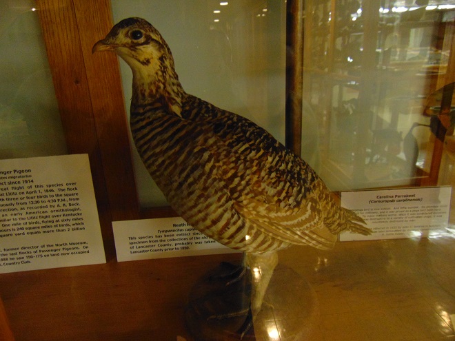
Among the mounted specimens in the North Museum collection is a Heath Hen, once a numerous coastal plain bird which was also of limited abundance in the Piedmont Province areas of southeast Pennsylvania prior to its rapid decline during the first half of the nineteenth century. In southern Lancaster County, the burned grasslands of the serpentine barrens in Fulton Township may have provided suitable Heath Hen habitat prior to the bird’s demise. Curiously, Judge John J. Libhart did not note the Heath Hen in his enumeration of the birds of Lancaster County in either 1844 or 1869, indicating it was seriously imperiled or may have already been extirpated.
The Heath Hen (Tympanuchus cupido cupido) became extinct in 1932. While the collection of this particular specimen had little significant impact on the population of this subspecies as a whole, prolonged hunting pressure was largely responsible for decimating the numbers of Heath Hens on the mainland of the Atlantic Coastal Plain. According to the museum tag, this specimen was “probably taken in southern Lancaster County prior to 1850”, and was part of the collection belonging to the Linnaean Society of Lancaster City and County. It is among hundreds of bird specimens on display in antique wood and glass cabinets in the North Museum.
The Heath Hen was extirpated from its entire Atlantic Coastal Plain mainland range by the mid-1860s. The last remaining population was restricted to Martha’s Vineyard where, for the first time, a conservation effort was initiated to try to save a species. After some promising rebounds, the Heath Hen’s recovery failed for a variety of reasons including: the population’s isolation on an island, severe winter storms, feral cat predation, and a flawed understanding of methods for conducting mosaic burns to maintain the bird’s scrub habitat and prevent large catastrophic fires. A large fire in 1906 reduced the island population to just 80 birds, then there was a strong rebound to an estimated 2,000 birds (800 counted) by April, 1916. One month later, a fire burned twenty percent of Martha’s Vineyard, striking while females were on the nest, and leaving mostly males as survivors. A downward spiral in numbers followed for another decade. Finally, from 1929 until his death in 1932, “Booming Ben”, the last Heath Hen, searched the island every spring for a mate that wasn’t there.
Based on life history and the morphology of specimens, the Heath Hen has long been considered to be a subspecies of the Greater Prairie Chicken (Tympanuchus cupido pinnatus), a bird of the tallgrass prairies. However, for more than a decade now, modern DNA analysis has kept taxonomists busy reclassifying and reworking the “tree of life”. For certain species, genetic discoveries often disqualify the long-trusted practice of determining a binomial name based on the visual appearance of specimens. Molecular study is making Linnaean classification more scientific, and is gradually untangling a web of names that man has been weaving for 200 years, often with scant evidence, in an effort to better understand the world around him. In the case of the Heath Hen, DNA research has thus far failed to conclusively determine its relationship to other species of prairie chickens. The lack of a sufficient pool of genetic material, particularly from mainland Heath Hens, reduces the ability of researchers to draw conclusions on this group of birds. There remains the possibility that the Heath Hen was genetically distinct from the Greater Prairie Chickens of the mid-western United States. This would be bad news for organizations studying the possibility of introducing the latter into the former’s historic range as a restoration program.
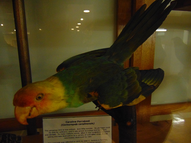
The Carolina Parakeet (Conuropsis carolinensis) specimen on display at the North Museum was collected by John C. Jenkins in Nanchez, Mississippi in 1835. The specimen was remounted by conservator H. Justin Roddy.
The last Carolina Parakeet (the only parrot species native to the eastern United States) died in captivity in the Cincinnati Zoo on February 21, 1918, one hundred years ago this past week. It was a species inhabiting primarily the lowland forests of the southeastern United States
In Lancaster County, Judge John J. Libhart wrote of the species in 1869, “…Carolina Parrot, Accidental; a flock seen near Manheim by Mr. G. W. Hensel.” Libhart did not mention the species in his earlier ornithological writings (1844). Therefore, the Hensel sighting probably occurred sometime between 1844 and 1869. The fate of a specimen reported to have been collected in the town of Willow Street sometime during the nineteenth century is unknown, the written details lack the date of its origin and other particulars that may clarify the authenticity of the sighting.
McKinley (1979) researched numerous historical sight records of Carolina Parakeets, but found no specimen from Lancaster County, or from Pennsylvania, New Jersey, Delaware, the District of Columbia, or Maryland to substantiate any of the reports in the Mid-Atlantic states. In the days prior to high-speed photography, verification and documentation of the presence of an animal species relied on what seems today to be a brutal and excessive method of nature study, killing. Lacking a specimen, the historical status of Carolina Parakeets in Pennsylvania, an area often considered to be within the bird’s former range, may be considered by many authorities to be hypothetical.
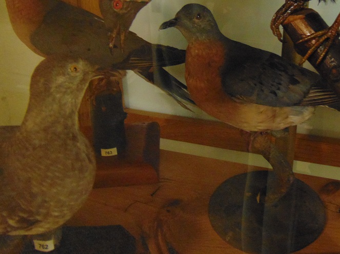
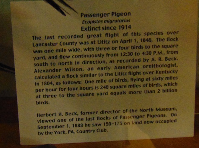
The Passenger Pigeon (Ectopistes migratorius) was abundant in the lower Susquehanna River valley through the early nineteenth century. Specimens in the North Museum collection include colorful males in breeding plumage. Several are from the original Linnaean Society of Lancaster City and County collection.
The Passenger Pigeon, too, has been extinct for more than a century. In Lancaster County, Judge John J. Libhart listed the Passenger Pigeon by the common name “Wild Pigeon” and wrote of the species in 1869, “Migratory; spring and autumn; feeds on grain, oak and beach, mostly on berries; stragglers sometimes remain and breed in the county.” There are numerous accounts of their precipitous decline both locally and throughout their former range, each illustrating the tragic loss of another portion of the North American natural legacy.
The North Museum specimen label describes the precipitous decline of the Passenger Pigeon in the lower Susquehanna River valley.
Martha, the last surviving Passenger Pigeon, died on September 1, 1914, in the Cincinnati Zoo. Ironically, the last Carolina Parakeet would die in the same enclosure just three-and-one-half years later. In the wild, the final three records of Passenger Pigeons were all of birds that were shot for taxidermy mounts in 1900, 1901, and 1902—an embarrassing human legacy.
By the early twentieth century, concerned citizens were beginning to realize the danger posed to many species of flora and fauna by man’s activities. In the eastern United States, the vast forests had been logged, the wetlands drained, and the streams and rivers dammed. Nearly all of the landscape had been altered in some way. Animals were harvested with little concern for the sustenance of their populations. Nearly unnoticed, the seemingly endless abundance and diversity of wildlife found in the early days of European colonization had dwindled critically.
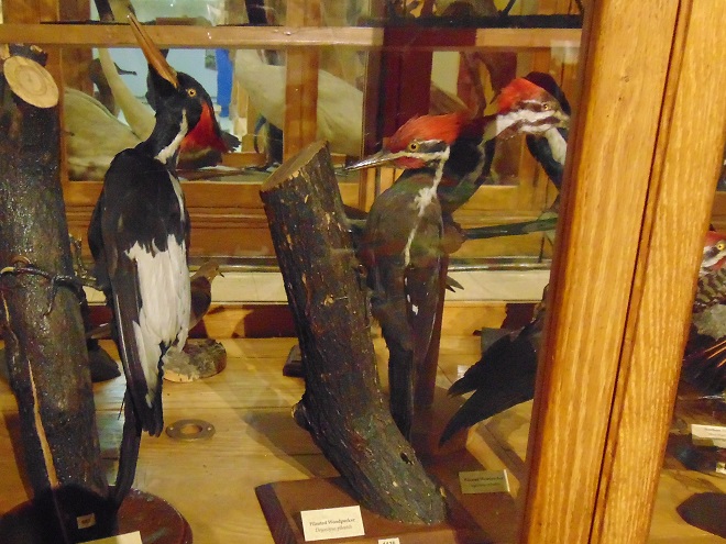
In 1844, Judge John J. Libhart noted the “Log-Cock” among the birds found in Lancaster County. Fortunately, he included the scientific name “Picus pileatus”, the binomial nomenclature then recognized for the Pileated Woodpecker (specimens to right) among taxonomists. A record of “Log-Cock” could confuse researchers, leaving them to guess whether Libhart was referring to a woodpecker, a woodcock, a grouse, or any number of other birds including the long-extinct(?) Ivory-billed Woodpecker (Campephilus principalis). Of the Pileated Woodpecker (Dryocopus pileatus today), Libhart wrote in 1869, “…now become rare and is only met with in old and extensive woods; breeds in the county.” The Ivory-billed Woodpecker (specimen to left), a species of vast forests of large timber, living and dead, was restricted to the southeastern United States and Cuba. Logging following the American Civil War and, to a lesser degree, shooting impacted both species detrimentally. The Pileated Woodpecker recovered, the larger Ivory-billed Woodpecker, which has never been documented in the northeastern United States, has not. These specimens are in the North Museum collection.
The movement to conserve and protect threatened species from relentless persecution owes its start to the Linnaean taxonomists, the specimen collectors who gave uniformly recognizable names to nearly all of North America’s plants and animals. Significant too were John James Audubon and many others who used specimens as models to create accurate artwork which allowed scientists and citizens alike to learn to identify and name the living things they were seeing and, as time went by, not seeing.
Binomial nomenclature enabled the new conservationists to communicate accurately, reducing misunderstandings resulting from the use of many different names for one species or a shared name for multiple species. Discussions on the status of Columba migratorius (the binomial name for Passenger Pigeon in the nineteenth century) could occur without using the confusing local names for the Passenger Pigeon such as Wood Pigeon or, here in Pennsylvania, Wild Pigeon, a term which could describe any number of free-ranging pigeon or dove species. A binomial name, genus and species, makes the identity of a particular plant or animal, for lack of a more fitting term, specific.
Appreciation for the work completed by taxonomists who killed thousands of animals so each could be classified and assigned a name particular to its lineage is what finally motivated some to seek a cessation of the unchecked catastrophic killing of living things. It’s the paradox of late nineteenth-century conservation. The combined realization that a species is unique among other life-forms and that continuing to kill it for specimens, “style”, “sport”, or just an adrenaline thrill could eliminate it forever became an intolerable revelation. The blood would be on the hands of an audacious mankind, and it was unthinkable. Something had to be done. Unfortunately for the Passenger Pigeon, the Carolina Parakeet, and the Heath Hen, help came too late.
SOURCES
Greenburg, Joel. 2014. A Feathered River Across the Sky: The Passenger Pigeon’s Flight to Extinction. Bloomsbury Publishing. New York.
Libhart, John J. 1844. “Birds of Lancaster County”. I. Daniel Rupp’s History of Lancaster County. Gilbert Hills. Lancaster, PA.
Libhart, John J. 1869. “Ornithology”. J. I. Mombert’s An Authentic History of Lancaster County. J. E. Barr and Company. Lancaster, PA.
McKinley, Daniel. 1979. “History of the Carolina Parakeet in Pennsylvania, New Jersey, Delaware, Maryland, and the District of Columbia”. Maryland Birdlife. 35(1):1-10.
Palkovacs, Eric P.; Oppenheimer, Adam J.; Gladyshev, Eugene; Toepfer, John E.; Amato, George; Chase, Thomas; Caccone, Adalgesia. 2004. “Genetic Evaluation of a Proposed Introduction: The Case of the Greater Prairie Chicken and the Extinct Heath Hen”. Molecular Ecology. 13(7):1759-1769.
Rathvon, S. S. 1866. An Essay on the Origin of the Linnaean Society of Lancaster City and County, Its Objects and Progress. Pearsol and Geist. Lancaster, Pennsylvania.
Wheeler, Alfred G., Jr. and Miller, Gary L. 2006. “Simon Snyder Rathvon: Popularizer of Agricultural Entomology in Mid-19th Century America”. American Entomologist. 52(1):36-47.
Winpenny, Thomas R. 1990. “The Triumphs and Anguish of a Self-Made Man: 19th Century Naturalist S. S. Rathvon”. Pennsylvania History. 57(2):136-149.
It was one of the very first of my memories. From the lawn of our home I could look across the road and down the hill through a gap in the woodlands. There I could see water, sometimes still with numerous boulders exposed, other times rushing, muddy, and roaring. Behind these waters was a great stone wall and beyond that a wooded hillside. I recall my dad asking me if I could see the dam down there. I couldn’t see a dam, just fascinating water and the gray wall behind it. I looked and searched but not a trace of a structure spanning the near to far shore was to be seen. Finally, at some point, I answered in the affirmative to his query; I could see the dam…but I couldn’t.
We lived in a small house in the village of Falmouth along the Susquehanna River in the northwest corner of Lancaster County over fifty years ago. A few years after we had left our riverside domicile and moved to a larger town, the little house was relocated to make way for an electric distribution sub-station and a second set of electric transmission wires in the gap in the woodlands. The Brunner Island coal-fired electric generating station was being upgraded downstream and, just upstream, a new nuclear-powered generating station was being constructed on Three Mile Island. To make way for the expanding energy grid, our former residence was trucked to a nearby boat landing where there were numerous other river shacks and cabins. Because it was placed in the floodplain, the building was raised onto a set of wooden stilts to escape high water. It didn’t help. The record-breaking floods of Hurricane Agnes in June of 1972 swept the house away.
The view through the cut in the woodland, a little wider than in the early 1960s with the addition of the newer electric transmission wire towers. The “Wall” is the same.
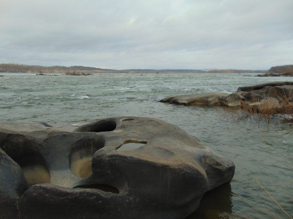
During the time we lived along the Susquehanna, the river experienced record-low flow rates, particularly in the autumn of 1963 and again in 1964. My dad was a dedicated 8mm home-movie photographer. Among his reels was film of buses parked haphazardly along the road (PA Route 441 today) near our home. Sightseers were coming to explore the widely publicized dry riverbed and a curious moon-like landscape of cratered rocks and boulders. It’s hard to fathom, but people did things like that during their weekends before Sunday-afternoon football was invented. Scores of visitors climbed through the rocks and truck-size boulders inspecting this peculiar scene. My dad, his friends, and so many others with camera in hand were experiencing the amazing geological feature known as the Pothole Rocks of Conewago Falls.
Conewago Falls on the Susquehanna River and several exposed York Haven Diabase Pothole Rocks. Lancaster (foreground) and Dauphin (center) Counties meet along a southwest to northeast borderline through the rapids. Lands on the west shoreline in the background are in York County. Three Mile Island is seen in the upper right.
The river here meets serious resistance as it pushes its way through the complex geology of south-central Pennsylvania. These hard dark-gray rocks, York Haven Diabase, are igneous in origin. Diabase sheets and sills intruded the Triassic sediments of the Gettysburg Formation here over 190 million years ago. It may be difficult to visualize, but these sediments were eroded from surrounding mountains into the opening rift valley we call the Gettysburg Basin. This rift and others in a line from Nova Scotia to Georgia formed as the supercontinent Pangaea began dividing into the continents we know today. Eventually the Atlantic Ocean rift would dominate as the active dynamic force and open to separate Africa from North America. The inactive Gettysburg Basin, filled with sediments and intruded by igneous diabase, would henceforth, like the mountainous highlands surrounding it, be subjected to millions of years of erosion. Of the regional rocks, the formations of Triassic redbeds, sandstones, and particularly diabase in the Gettysburg Basin are among the more resistant to the forces of erosion. Many less resistant older rocks, particularly those of surrounding mountains, are gone. Today, the remains of the Gettysburg Basin’s rock formations stand as rolling highlands in the Piedmont Province.
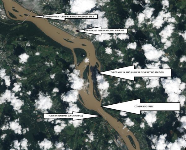
Flooded from the heavy rains of Tropical Storm Lee, the sediment-laden Susquehanna River flows through the Gettysburg Basin just south of Harrisburg, PA, September 10, 2011. The “Wall” as seen from space. (NASA Earth Observatory Image)
The weekend visitors in 1963 and 1964 marveled at evidence of the river’s fight to break down the hard York Haven Diabase. Scoured bedrock traced the water’s turbulent flow patterns through the topography of the falls. Meltwater from the receding glaciers of the Pleistocene Ice Ages thousands to tens of thousands of years ago raged in high-volume, abrasive-loaded torrents to sculpt the Pothole Rocks into the forms we see today. Our modern floodwaters with ice and fine suspended sediments continue to wear at the smooth rocks and boulders, yet few are broken or crumbled to be swept away. It’s a very slow process. The river elevation here drops approximately 19 feet in a quarter of a mile, a testament to the bedrock’s persisting resistance to erosion. Conewago Falls stands as a natural anomaly on a predominantly uniform gradient along the lower Susquehanna’s downhill path from the Appalachian Mountains to the Chesapeake Bay.
Normally the scene of dangerous tumbling rapids, the drought and low water of 1963 and 1964 had left the falls to resemble a placid scene—a moonscape during a time when people were obsessed with mankind’s effort to visit earth’s satellite. Visitors saw the falls as few others had during the twentieth century. Dr. Herbert Beck of Franklin and Marshall College described an earlier period of exposure, “…pot holes…were uncovered during the third week in October, 1947, for the first time in the memory of man, when the drought parched Susquehanna River retreated far below its normal low stage”. Then, as in 1963 and on occasions more recent, much of it was due to the presence of the wall. I had to be a bit older than four years old to grasp it. You see the wall and the dam are one and the same. The wall is the York Haven Dam. And it is responsible for channeling away the low flow of the Susquehanna during periods of drought so that we might have the opportunity to visit and explore the Pothole Rocks of Conewago Falls along the river’s east shore.
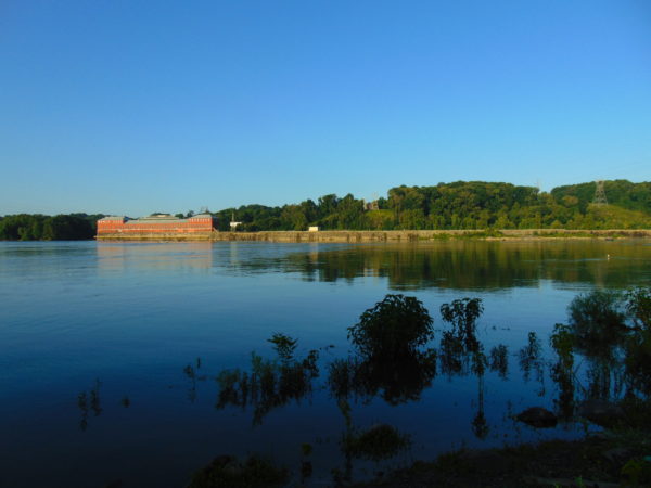
The initial segment of the dam, a crib structure built in 1885 by the York Haven Paper Company to supply water power to their mill, took advantage of the geomorphic features of the diabase bedrock of Conewago Falls to divert additional river flow into the abandoned Conewago Canal. The former canal, opened in 1797 to allow passage around the rapids along the west shore, was being used as a headrace to channel water into the grinding mill’s turbines. Strategic placement of this first wall directed as much water as possible toward the mill with the smallest dam practicable. The York Haven Power Company incorporated the paper mill’s crib dam into the “run-of-the-river” dam built through the falls from the electric turbine powerhouse they constructed on the west shore to the southern portion of Three Mile Island more than a mile away. The facility began electric generation in 1904. The construction of the “Red Hill Dam” from the east shore of Three Mile Island to the river’s east shore made York Haven Dam a complete impoundment on the Susquehanna. The pool, “Lake Frederic”, thus floods that portion of the Pothole Rocks of Conewago Falls located behind the dam. On the downstream side, water spilling over or through the dam often inundates the rocks or renders them inaccessible.
During the droughts of the early 1960s, diversion of nearly all river flow to the York Haven Dam powerhouse cleared the way for weekend explorers to see the Pothole Rocks in detail. Void of water, the intriguing bedrock of Conewago Falls below the dam greeted the curious with its ripples, cavities, and oddity. It was an opportunity nature alone would not provide. It was all because of the wall.
York Haven Dam and powerhouse. The “Wall” traverses Conewago Falls upstream to Three Mile Island to direct water to the powerhouse on the west shore of the Susquehanna River.
SOURCES
Beck, Herbert H. 1948. “The Pot Holes of Conewago Falls”. Proceedings of the Pennsylvania Academy of Science. Penn State University Press. 22: pp. 127-130.
Smith, Stephen H. 2015. #6 York Haven Paper Company; on the Site of One of the Earliest Canals in America. York Past website www.yorkblog.com/yorkpast/2015/02/17/6-york-haven-paper-company-on-the-site-of-one-of-the-earliest-canals-in-america/ as accessed July 17, 2017.
Stranahan, Susan Q. 1993. Susquehanna, River of Dreams. The Johns Hopkins University Press. Baltimore, Maryland.
Van Diver, Bradford B. 1990. Roadside Geology of Pennsylvania. Mountain Press Publishing Company. Missoula, Montana.