
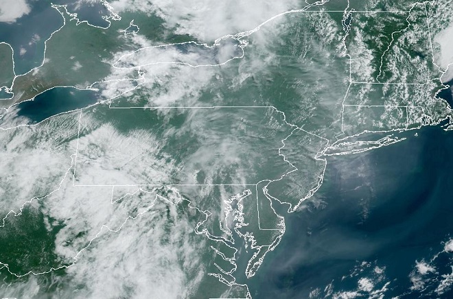
Today’s NOAA/GOES satellite image serves as a little reminder of the big three. That’s right, it’s the three big “natural” disasters—wildfires, inland flooding, and coastal flooding (lucky for us, our region is at present millions of years removed from severe threats posed by the tectonic disasters—earthquakes, volcanoes, and tsunamis—and is not particularly prone to frequent tornadoes). Each continues to cause an increasing volume of property damage and threaten a greater number of lives because of where and how we choose to make our homes and erect our structures.

For all of human existence, the dynamics of the atmosphere have been shaping the topography and the ecosystems of the planet. In recent times, we’ve had the advantage of satellite technologies to show us spectacular images of atmospheric events as they happen. And through the various branches of science, we’ve come to understand the impact these events have upon the landscape and the people who live and/or work there.
Forestry sciences have helped us to understand how natural fuels, humidity, temperature, rainfall, soil moisture, wind, and human encroachment influence the frequency and severity of wildfires. These discoveries have led to changes in forest management and implementation of practices such as prescribed burns to reduce accumulated fuel loads. Because human development typically lowers soil moisture and brings along with it additional sources of ignition, many land managers and fire departments have warned of the ever increasing dangers of wildland-urban interface fires. These warnings have gone largely unheeded for more than four decades as millions of homes and other combustible structures have been erected within areas prone to fires capable of uncontrollable growth into disastrous conflagrations. The tinderbox wildlands—they’re a nice place to visit, but we ought not to live there!
Tropical storms and other sources of heavy precipitation bring about quite the hubbub over flooding. Meteorologists spend a lot of time explaining it all, but it’s almost as if no one pays any mind. For a people who check the weather forecast several times a day, every day of our adult life, just to get a leg up on how that weather is going to change day by day and hour by hour, you would think we would better anticipate the climatic events that happen over the long term. In particular, you would think we would have an awareness of our own individual susceptibility to flooding— a grasp of how, where, and why floods occur. You would think that repeated episodes of flooding would compel society to embrace an ethic that treated water as the valuable commodity it is. Yet, we all seem to follow the same patterns of behavior. First, we drain, dump, pipe, curb, channel, ditch, grade, pave, and pump to get the rain that falls upon our property off of our property. Then, the chump downstream gets really mad that we sent our water his way and flooded him out, so he takes the same measures to send even more water to the next poor slob down the line until finally the now polluted slurry of runoff floods the street, a cellar, a house, a business, or a stream—a stream that has been channelized so it no longer has a floodplain to absorb, hold, purify, and infiltrate the stormwater. Why was the stream channelized? So we could fill in the floodplain and build upon it of course. Two things come to mind here. First, if we’re going to be selfish enough to flood out our neighbors, then why shouldn’t we be totally selfish and keep for ourselves all the water that falls upon our place. After all, we’re going to need that water some day. And second, the floodplain is a nice place to visit, but we ought not to build there. Floodplains are for flooding; thousands of years of erosion have shaped them that way—it’s a gravity thing!
Next, we look at the lessons from geology, more specifically coastal geomorphology. Through these disciplines we know that the coastal plain—the flat land that spent most of the last 35.5 million years (the time since the meteor strike at the present-day mouth of Chesapeake Bay) as a beach or a tidal marsh—today stands mostly less than three dozen feet above sea level. We know that the sands forming barrier islands along the Atlantic seaboard, which are only several feet above sea level, shift their shape and position with the tides. Over the decades and centuries, these islands migrate and compensate for changes in climate and tidal patterns as well as sea levels. Behind their shifting dunes, vast tidal marshes are protected from seasonal storms including the periodic nor’easter or hurricane. Despite the importance of barrier island dynamics to the integrity of the bays and estuaries they protect, and despite their vulnerability to coastal storm surges, winds, and flooding, we choose to build there. In fact, the greatest population densities in the United States, and in many other countries of the world, are on the beach. It’s not because these hundreds of millions of people are fishing or loading/unloading ships for a living—it’s mostly for the view. Despite their importance to fisheries and other coastal life, we continue to alter and destroy the near-tidal areas of the the barrier islands and bays. We go to great expense to “save” for our uses the lands that should be getting inundated by rising sea levels to create new shallow tidewater zones. We waste spectacular amounts of money pumping sand back onto beaches to keep naturally migrating sediments from changing their shape and position in response to the tides. We keep putting more people and more capital at risk by urbanizing these low-lying areas. Building on the beach is absolute madness. It’s an ecological catastrophe from day one and a human catastrophe soon after.
All of the lands impacted by these natural events have two things in common. Each becomes a potential disaster area if people choose to construct their homes or businesses there. And each, if left in its wild state and given a buffer space from human activity, reacts with natural time-derived mechanisms in response to the same events. These mechanisms are often essential for provision of the unique ecosystems required by many of our most threatened wildlife species. Human encroachment into floodplains, wetlands, tidal marshes, beaches, and xeric uplands is a double-edged sword. It first decimates populations of these uncommon species by destroying and fragmenting their specialized habitats. Then, it sets the stage for the fires, floods, and other disasters that endanger the lives and property of the people living there. Considering the ramifications of building in these fire and flood susceptible areas, we can and should live somewhere else, especially when the wildlife requiring these places often can’t.


