Two days ago, widespread rain fell intermittently through the day and steadily into the night in the Susquehanna drainage basin. The temperature was sixty degrees, climbing out of a three-week-long spell of sub-freezing cold in a dramatic way. Above the ice-covered river, a very localized fog swirled in the southerly breezes.
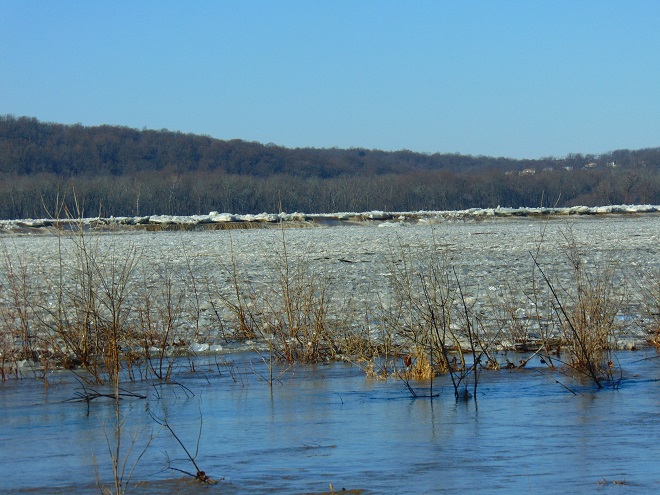
By yesterday, the rain had ended as light snow and a stiff wind from the northwest brought sub-freezing air back to the region. Though less than an inch of rain fell during this event, much of it drained to waterways from frozen or saturated ground. Streams throughout the watershed are being pushed clear of ice as minor flooding lifts and breaks the solid sheets into floating chunks.
Today, as their high flows recede, the smaller creeks and runs are beginning to freeze once again. On larger streams, ice is still exiting with the cresting flows and entering the rising river.
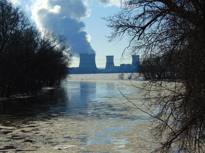
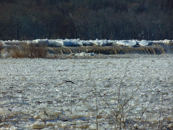
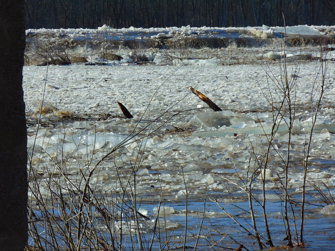
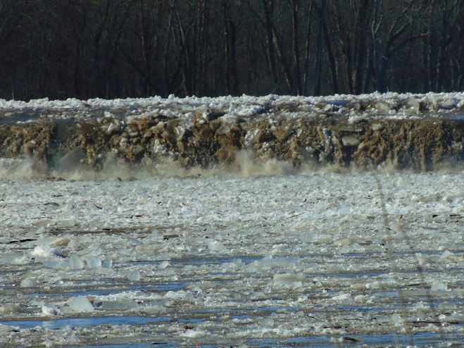
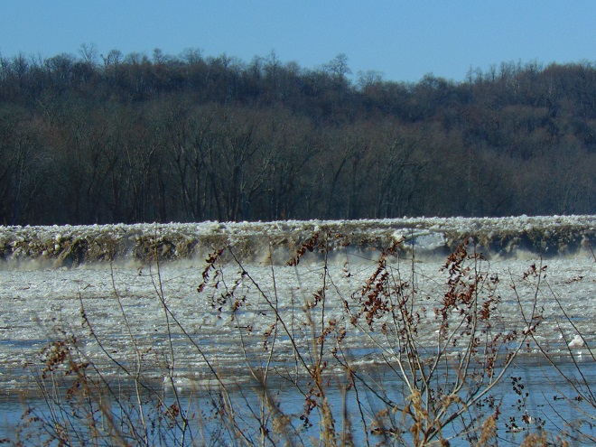
Ice chunks on Swatara Creek merge into a dense flow of ice on the river in the distance. Swatara Creek is the largest tributary to enter the Susquehanna in the Gettysburg Basin. The risk of an ice jam impounding the Swatara here at its mouth is lessened because rising water on the river has lifted and broken the ice pack to keep it moving without serious impingement by submerged obstacles. Immovable ice jams on the river can easily block the outflow from tributaries, resulting in catastrophic flooding along these streams.Fast-moving flows of jagged ice race toward Three Mile Island and Conewago Falls. The rising water began relieving the compression of ice along the shoreline during the mid-morning. Here on the river just downstream of the mouth of Swatara Creek, ice-free openings allowed near-shore piles to separate and begin floating away after 10:30 A.M. E.S.T. Moving masses of ice created loud rumbles, sounding like a distant thunderstorm.Ice being pushed and heaved over the crest of the York Haven Dam at Conewago Falls due to compression and rising water levels.Enormous chunks of ice being forced up and over the York Haven Dam into Conewago Falls and the Pothole Rocks below.Ice scours Conewago Falls, as it has for thousands of years.The action of ice and suspended abrasives has carved the York Haven Diabase boulders and bedrock of Conewago Falls into the amazing Pothole Rocks.The roaring torrents of ice-choked water will clear some of the woody growth from the Riverine Grasslands of Conewago Falls.To the right of center in this image, a motorcar-sized chunk of ice tumbles over the dam and crashes into the Pothole Rocks. It was one of thousands of similar tree-and-shrub-clearing projectiles to go through the falls today.
The events of today provide a superb snapshot of how Conewago Falls, particularly the Diabase Pothole Rocks, became such a unique place, thousands of years in the making. Ice and flood events of varying intensity, duration, and composition have sculpted these geomorphologic features and contributed to the creation of the specialized plant and animal communities we find there. Their periodic occurrence is essential to maintaining the uncommon habitats in which these communities thrive.
Fish Crows (Corvus ossifragus) gather along the flooding river shoreline. Soon there’ll be plenty of rubbish to pick through, some carrion maybe, or even a displaced aquatic creature or two to snack upon.
Is this the same Conewago Falls I visited a week ago? Could it really be? Where are all the gulls, the herons, the tiny critters swimming in the potholes, and the leaping fish? Except for a Bald Eagle on a nearby perch, the falls seems inanimate.
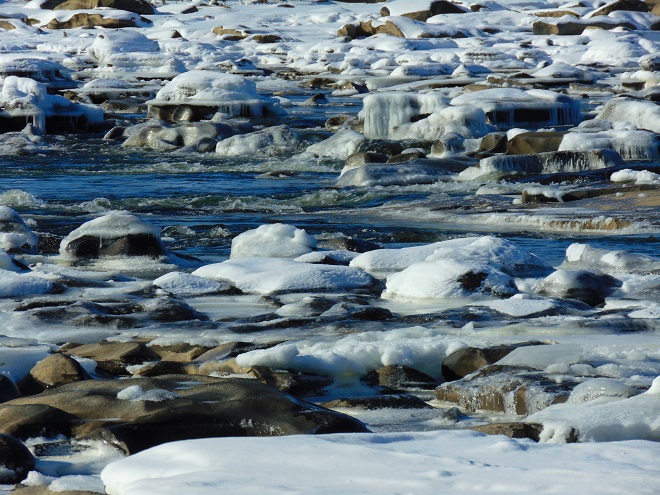
Yes, a week of deep freeze has stifled the Susquehanna and much of Conewago Falls. A hike up into the area where the falls churns with great turbulence provided a view of some open water. And a flow of open water is found downstream of the York Haven Dam powerhouse discharge. All else is icing over and freezing solid. The flow of the river pinned beneath is already beginning to heave the flat sheets into piles of jagged ice which accumulate behind obstacles and shallows.
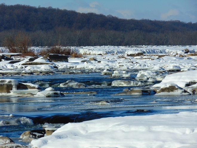
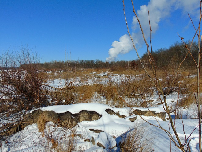
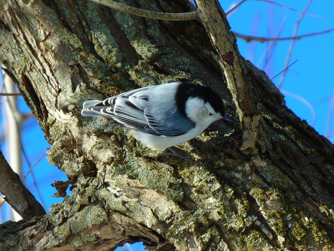
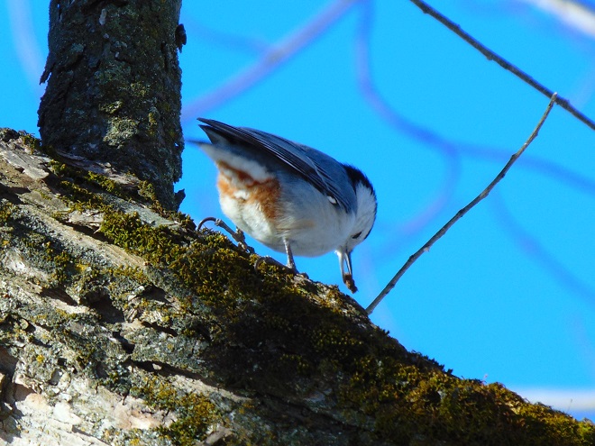
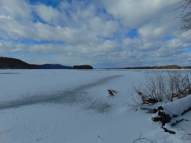
Ice and snow surround a small zone of open water in a high-gradient area of Conewago Falls.Ice chunks and sheets accumulate atop the York Haven Dam. The weight of miles of ice backed up behind the dam eventually forces the accumulation over the top and into the Pothole Rocks below. The popping and cracking sounds of ice both above and below the dam could be heard throughout the day as hydraulic forces continuously break and move ice sheets.Steam from the Unit 1 cooling towers at the Three Mile Island Nuclear Generating Station rises above the frozen Riverine Grasslands at Conewago Falls. The scouring action of winter ice keeps the grasslands clear of substantial woody growth and prevents succession into forest.Despite a lack of activity on the river, mixed flocks of resident and wintering birds, including this White-breasted Nuthatch (Sitta carolinensis), were busy feeding in the Riparian Woodlands. The White-breasted Nuthatch is a cavity nester and year-round denizen of hardwoods, often finding shelter during harsh winter nights in small tree holes.The White-breasted Nuthatch is often seen working its way head-first down a tree trunk as it probes with its well-adapted bill for insects among the bark.Jackpot!Looking upstream from the river’s east shore at ice and snow cover on the Susquehanna above Conewago Falls and the York Haven Dam. The impoundment, known as Lake Frederic, and its numerous islands of the Gettysburg Basin Archipelago were locked in winter’s frosty grip today. Hill Island (Left) and Poplar Island (Center) consist of erosion-resistant York Haven Diabase, as does the ridge on the far shoreline seen rising in the distance between them. To the right of Poplar Island in this image, the river passes by the Harrisburg International Airport. At the weather station there, the high temperature was eighteen degrees Fahrenheit on this first day of 2018.
It was one of the very first of my memories. From the lawn of our home I could look across the road and down the hill through a gap in the woodlands. There I could see water, sometimes still with numerous boulders exposed, other times rushing, muddy, and roaring. Behind these waters was a great stone wall and beyond that a wooded hillside. I recall my dad asking me if I could see the dam down there. I couldn’t see a dam, just fascinating water and the gray wall behind it. I looked and searched but not a trace of a structure spanning the near to far shore was to be seen. Finally, at some point, I answered in the affirmative to his query; I could see the dam…but I couldn’t.
We lived in a small house in the village of Falmouth along the Susquehanna River in the northwest corner of Lancaster County over fifty years ago. A few years after we had left our riverside domicile and moved to a larger town, the little house was relocated to make way for an electric distribution sub-station and a second set of electric transmission wires in the gap in the woodlands. The Brunner Island coal-fired electric generating station was being upgraded downstream and, just upstream, a new nuclear-powered generating station was being constructed on Three Mile Island. To make way for the expanding energy grid, our former residence was trucked to a nearby boat landing where there were numerous other river shacks and cabins. Because it was placed in the floodplain, the building was raised onto a set of wooden stilts to escape high water. It didn’t help. The record-breaking floods of Hurricane Agnes in June of 1972 swept the house away.
The view through the cut in the woodland, a little wider than in the early 1960s with the addition of the newer electric transmission wire towers. The “Wall” is the same.
During the time we lived along the Susquehanna, the river experienced record-low flow rates, particularly in the autumn of 1963 and again in 1964. My dad was a dedicated 8mm home-movie photographer. Among his reels was film of buses parked haphazardly along the road (PA Route 441 today) near our home. Sightseers were coming to explore the widely publicized dry riverbed and a curious moon-like landscape of cratered rocks and boulders. It’s hard to fathom, but people did things like that during their weekends before Sunday-afternoon football was invented. Scores of visitors climbed through the rocks and truck-size boulders inspecting this peculiar scene. My dad, his friends, and so many others with camera in hand were experiencing the amazing geological feature known as the Pothole Rocks of Conewago Falls.
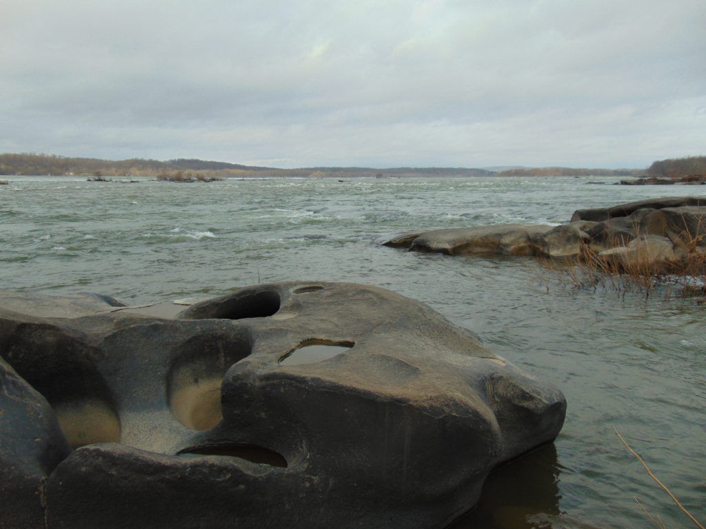
Conewago Falls on the Susquehanna River and several exposed York Haven Diabase Pothole Rocks. Lancaster (foreground) and Dauphin (center) Counties meet along a southwest to northeast borderline through the rapids. Lands on the west shoreline in the background are in York County. Three Mile Island is seen in the upper right.
The river here meets serious resistance as it pushes its way through the complex geology of south-central Pennsylvania. These hard dark-gray rocks, York Haven Diabase, are igneous in origin. Diabase sheets and sills intruded the Triassic sediments of the Gettysburg Formation here over 190 million years ago. It may be difficult to visualize, but these sediments were eroded from surrounding mountains into the opening rift valley we call the Gettysburg Basin. This rift and others in a line from Nova Scotia to Georgia formed as the supercontinent Pangaea began dividing into the continents we know today. Eventually the Atlantic Ocean rift would dominate as the active dynamic force and open to separate Africa from North America. The inactive Gettysburg Basin, filled with sediments and intruded by igneous diabase, would henceforth, like the mountainous highlands surrounding it, be subjected to millions of years of erosion. Of the regional rocks, the formations of Triassic redbeds, sandstones, and particularly diabase in the Gettysburg Basin are among the more resistant to the forces of erosion. Many less resistant older rocks, particularly those of surrounding mountains, are gone. Today, the remains of the Gettysburg Basin’s rock formations stand as rolling highlands in the Piedmont Province.
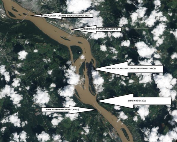
Flooded from the heavy rains of Tropical Storm Lee, the sediment-laden Susquehanna River flows through the Gettysburg Basin just south of Harrisburg, PA, September 10, 2011. The “Wall” as seen from space. (NASA Earth Observatory Image)
The weekend visitors in 1963 and 1964 marveled at evidence of the river’s fight to break down the hard York Haven Diabase. Scoured bedrock traced the water’s turbulent flow patterns through the topography of the falls. Meltwater from the receding glaciers of the Pleistocene Ice Ages thousands to tens of thousands of years ago raged in high-volume, abrasive-loaded torrents to sculpt the Pothole Rocks into the forms we see today. Our modern floodwaters with ice and fine suspended sediments continue to wear at the smooth rocks and boulders, yet few are broken or crumbled to be swept away. It’s a very slow process. The river elevation here drops approximately 19 feet in a quarter of a mile, a testament to the bedrock’s persisting resistance to erosion. Conewago Falls stands as a natural anomaly on a predominantly uniform gradient along the lower Susquehanna’s downhill path from the Appalachian Mountains to the Chesapeake Bay.
Normally the scene of dangerous tumbling rapids, the drought and low water of 1963 and 1964 had left the falls to resemble a placid scene—a moonscape during a time when people were obsessed with mankind’s effort to visit earth’s satellite. Visitors saw the falls as few others had during the twentieth century. Dr. Herbert Beck of Franklin and Marshall College described an earlier period of exposure, “…pot holes…were uncovered during the third week in October, 1947, for the first time in the memory of man, when the drought parched Susquehanna River retreated far below its normal low stage”. Then, as in 1963 and on occasions more recent, much of it was due to the presence of the wall. I had to be a bit older than four years old to grasp it. You see the wall and the dam are one and the same. The wall is the York Haven Dam. And it is responsible for channeling away the low flow of the Susquehanna during periods of drought so that we might have the opportunity to visit and explore the Pothole Rocks of Conewago Falls along the river’s east shore.
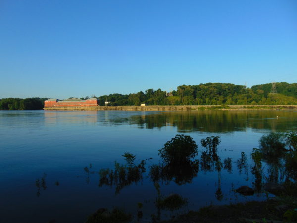
The initial segment of the dam, a crib structure built in 1885 by the York Haven Paper Company to supply water power to their mill, took advantage of the geomorphic features of the diabase bedrock of Conewago Falls to divert additional river flow into the abandoned Conewago Canal. The former canal, opened in 1797 to allow passage around the rapids along the west shore, was being used as a headrace to channel water into the grinding mill’s turbines. Strategic placement of this first wall directed as much water as possible toward the mill with the smallest dam practicable. The York Haven Power Company incorporated the paper mill’s crib dam into the “run-of-the-river” dam built through the falls from the electric turbine powerhouse they constructed on the west shore to the southern portion of Three Mile Island more than a mile away. The facility began electric generation in 1904. The construction of the “Red Hill Dam” from the east shore of Three Mile Island to the river’s east shore made York Haven Dam a complete impoundment on the Susquehanna. The pool, “Lake Frederic”, thus floods that portion of the Pothole Rocks of Conewago Falls located behind the dam. On the downstream side, water spilling over or through the dam often inundates the rocks or renders them inaccessible.
During the droughts of the early 1960s, diversion of nearly all river flow to the York Haven Dam powerhouse cleared the way for weekend explorers to see the Pothole Rocks in detail. Void of water, the intriguing bedrock of Conewago Falls below the dam greeted the curious with its ripples, cavities, and oddity. It was an opportunity nature alone would not provide. It was all because of the wall.
York Haven Dam and powerhouse. The “Wall” traverses Conewago Falls upstream to Three Mile Island to direct water to the powerhouse on the west shore of the Susquehanna River.
SOURCES
Beck, Herbert H. 1948. “The Pot Holes of Conewago Falls”. Proceedings of the Pennsylvania Academy of Science. Penn State University Press. 22: pp. 127-130.
Smith, Stephen H. 2015. #6 York Haven Paper Company; on the Site of One of the Earliest Canals in America. York Past website www.yorkblog.com/yorkpast/2015/02/17/6-york-haven-paper-company-on-the-site-of-one-of-the-earliest-canals-in-america/ as accessed July 17, 2017.
Stranahan, Susan Q. 1993. Susquehanna, River of Dreams. The Johns Hopkins University Press. Baltimore, Maryland.
Van Diver, Bradford B. 1990. Roadside Geology of Pennsylvania. Mountain Press Publishing Company. Missoula, Montana.