Clean rainwater flowing from the roofs of our homes and other buildings is a precious resource that is more often than not directed as quickly as possible into streets and storm drains to become contaminated runoff capable of polluting streams and aggravating flooding conditions. The prudent property steward will manage rainfall as the treasured commodity that it is—retaining on site as much of it as possible.
Whether you happen to be obtaining your domestic water from a community distribution system or from a private well, infiltrating the rain that falls on your roof directly into the soil is a good way to make sure it helps recharge the groundwater stored in the aquifer—banking it for future use.
Better yet, rain barrels provide a means of intercepting, storing, and dispensing a share of the precipitation from your downspouts before it is discharged into the ground. Water from rain barrels can be drained to hydrate garden plants, rinse the patio, wash the dog, or, in the event of an emergency, fill the need for non-potable uses that include bathing and flushing toilets. For potable applications such as cooking, drinking, and brushing teeth, roof water must first be filtered and disinfected.
Rain barrels collect and save clean roof water for later use. For every one inch of precipitation, the roof on a house or other building with a footprint of just 1,200 square feet sheds enough to fill about fourteen 55-gallon drums. Live in a home supplied by a well? That’s over 700 gallons of soft water available as you need it, such as during a power outage when the pump won’t operate.
Here at susquehannawildlife.net headquarters, our goal is “no net runoff” from our little urban parcel. We use three rain barrels to catch discharge from the spouting system, then direct the overflow into three different management configurations.
RAIN GARDEN
Precipitation from the downspout is captured in this commercially produced rain barrel. The overflow is directed into the black corrugated pipe……and spilled into the gravel bed in the rain garden to both water the plants and infiltrate into the ground to recharge our local aquifer.The gravel beds diffuse energy produced not only by water rushing from the barrel’s overflow, but from sheet runoff entering the garden from the driveway and neighboring street.
STOCK TANK PLANTER
This home-brew rain barrel was fabricated from a 55-gallon drum originally used to ship and store car wash soap. We scrubbed it out, then plumbed it up with the overflow feeding a 100-gallon stock tank fashioned into a planter. The drain from the planter sometimes discharges a trickle of water into a porous area of the pavement where it soon percolates into the ground. In this “container rain garden”, we grow wildflowers, sedges, rushes, and warm-season grasses.
THE GARDEN POND/POOLS
Here’s another rain barrel made from a soap drum. This one discharges its overflow into the upper pool of our garden pond.Upon topping off the barrel, clean roof water spills into the corrugated pipe and tumbles into the upper pool. Outflow from the upper pool cascades through the the riffles/falls……into the lower pool (bottom right). The lower pool consists of a 100-gallon stock tank sunk below grade level and surrounded by rock. Throughout the summer, a pump located in this “sump” circulates water to a spring-like feature in the upper pool. During a downpour, the lower pool will overflow into the encircling boulders, the level often rising half a foot or more above the top rim of the stock tank flooding the cap stones before receding as the excess water slowly infiltrates down through the gravelly soils. It’s a self-automated, hassle-free water change that helps keep our pools and their inhabitants healthy.Our garden pond stormwater management system keeps the pools topped off and the aquatic ecosystem thriving.
Why not give roof water management a try on your property? It’s a great project for exercising your ingenuity and creativity while doing something truly beneficial for the watershed within which you reside. Best of all, it’s really not that expensive to get started.
The dynamics of water’s storage and movement on earth, as well as its transitions through the primary states of matter—gas, liquid, and solid—are known as the water cycle. Understanding how life-supporting water progresses through the global biosphere can provide each of us with a greater appreciation of how fragile a resource clean water is in the presence of 8.3 billion wasteful and polluting humans.
This graphic created by the United States Geological Survey illustrates many of the components of the water cycle’s complex processes. Have a look…
The Water Cycle. Click the image for an enlarged view. (United States Geological Survey image)
For a PDF version which includes a more detailed description along the bottom margin, click here. We like it so much, we’ve added it to this webpage’s sidebar for future reference.
If you’ve visited Middle Creek Wildlife Management Area anytime during the past month, you may have noticed quite a bit of activity around the large pole-mounted nest boxes placed out in the open fields.
American Kestrels, a male and female, at a nest box at Middle Creek Wildlife Management Area.Within the past week, we noticed that kestrels are still competing for nesting sites and territory, driving away unwanted trespassers. A pair of kestrels seemed to be occupying each of the four box sites we observed. That’s good news, but the presence of these man-made nest cavities is in no way wholly responsible for this positive response from these declining birds. It’s a matter of habitat, much needed grassland habitat.Cool-season grasses including fescue (Lolium species) and non-native Orchard Grass (Dactylis glomerata) mature by late spring. If left standing, they continue to provide indispensable habitat for grassland wildlife through the summer. Mowing early and often for hay harvest has rendered most cool-season meadows death traps for nesting birds. By delaying cuttings until at least early August, ground-nesting birds are given adequate time to fledge their young and get the juvenile birds strong enough to fly away from a set of spinning blades.A male Grasshopper Sparrow sings to demarcate its nesting territory in a stand of Timothy, an introduced species cultivated for harvest as hay. An insectivore during the breeding season, he and his mate will attempt to raise their brood exclusively within the cover of these cool-season grasses.Eastern Meadowlarks arrive in cool-season grasslands by late-winter to begin their breeding cycle which typically extends into the hot summer days of July.Prior to being mowed, Orchard Grass provides the short, dense cover meadowlarks and other ground-nesting grassland birds need to successfully reproduce. Growing a cool season grassland can be as easy as delaying the mowing of a pasture, field, or oversize lawn until August, then have a farmer friend come and take off a cutting or two of hay or straw to prevent woody plants from becoming established.More durable stands of native warm-season grasses including Big Bluestem, Indiangrass, Switchgrass, and Little Bluestem thrive in the summer heat and provide wildlife habitat throughout the year. These perennial “prairie grasses”, fed by root systems five to eight feet deep, are especially drought tolerant . From these entrenched anchors, the plants would quickly bounce back after the once great herds of hungry bison had grazed the landscape bare of surface vegetation before moving on. This adaptation also assured “prairie grass” regeneration following naturally occurring seasonal fires, events mimicked in eastern North America by its earliest human residents. They used recurrent fire to perpetuate early successional habitat for wildlife propagation, foraging, and agriculture. Today in the lower Susquehanna watershed, establishing warm-season grassland meadows requires soil prep and seeding to get things going again.To prevent succession, warm-season grassland parcels are most commonly maintained using applications of prescribed fire every 3 to 5 years. Among their benefits, these burns invigorate native vegetation while inhibiting the invasive tendencies of many non-native plants. Well-planned periodic fire can significantly reduce fuel accumulations, particularly in tinderbox woodland tracts managed as fire-free zones for the past century or more. Many forest trees including oaks rely on sporadic fire events for regeneration.
LEARN HOW LAND MANAGERS UTILIZE PRESCRIBED FIRE
This coming Saturday, April 18, 2026, beginning at 10 A.M. (rain date April 25), the Pennsylvania Game Commission is hosting a “Prescribed Fire Festival” at Middle Creek Wildlife Management Area. Be certain to come out to the visitor’s center at 100 Museum Road, Stevens, PA, for this event. Land managers will be there to answer questions and to explain the planning and preparations involved in overseeing a prescribed burn. There will be guided walks of habitats preserved using fire of varying intensities. You’ll see the equipment and protective clothing used by certified personnel to administer a live prescribed fire burn right before your eyes. Then you can have lunch—food trucks will be available on site.
Visitors witness a prescribed fire demonstration at the Pennsylvania Game Commission’s Middle Creek Wildlife Management Area in 2025.
After the burn demonstration, why not go for a walk or drive around the refuge. You can take note of how grassland and early successional plant communities are responding to previous doses of prescribed fire…
Greening up a week or two after the burn, Wingstem is blooming by June in areas treated using prescribed fire earlier in the spring.Another scene from June: Four-foot-tall Joe-Pye-Weed amidst lush growth of goldenrod in early successional habitat where a prescribed burn eliminated accumulating wildfire fuel and turned back the growth of invasive plant species in March.
And how the grassland animals respond as well…
Ring-necked Pheasants in early successional habitat maintained by the periodic application of prescribed fire.Eastern Cottontails prosper in the mosaic of warm-season grasses and early successional thickets on lands sustained using prescribed fire. Rabbits are herbivores, primary consumers eating mostly legumes and other plants, the producers that through the process of photosynthesis convert the energy of the the sun into food energy.Other small vegetation-eating rodents including mice and voles thrive in managed grasslands. Similar in appearance are the shrews. Though seldom noticed, Northern Short-tailed Shrews spend day and night foraging for food, even in the shallow waters of wet meadows and thickets. Unlike the aforementioned herbivorous rodents, shrews are insectivores, secondary consumers feeding mostly on primary consumers including a variety of insects and other arthropods.Some years ago, we found this tiny Masked Shrew (Sorex cinereus) in a grassland area being preserved using prescribed fire. Like other shrews, Masked Shrews are secretive, but always on the go. They feed constantly to fuel their vast energy requirements, sometimes consuming three times their body weight in a single day. But their voracious appetite can get them into trouble, causing these incessant eaters to encounter numerous potentially infective parasites during their non-stop foraging missions.Patrolling the grasslands is the female American Kestrel, a secondary consumer. She’s on the lookout for primary consumers including large insects like grasshoppers or crickets. But perhaps more likely is a small rodent whose less-than-ideal vigor may cause it to slip up, creating an easy target. If she selects a careless shrew as her prey, she may be assuming the role of a tertiary consumer, eating a secondary consumer (the shrew) that fed on insects (the primary consumers) that derived their energy from photosynthesized plant matter.The strictly nocturnal American Barn Owl (Tyto furcata), another secondary and sometimes tertiary consumer, takes the night shift, hunting unwary voles, mice, and shrews, often by sensing the sounds they make among runways in the grass. As a native predator in its favored habitat, the owl’s selection of each victim actually helps to keep the prey species’ population healthy, eliminating the weak and vulnerable to provide a qualitative service to the surviving wildlife of the grasslands. While we may not think of the barn owl as a direct consumer of insects, its positive influence on insectivorous shrew populations makes it an important functionary in maintaining balance in the ecosystems it calls home.As food becomes increasing plentiful in the grasslands, a female kestrel will remain mostly out of sight, performing the majority of the egg incubation duties while her colorful mate stands guard nearby.The male not only keeps watch, but also continues the hunt for insects, small mammals, and other prey to feed not only the newborn nestlings, but also his mate while she tends the nest. As the young grow and no longer need brooding to stay warm, the female will join the male in a joint effort to snatch up enough food to keep their three to seven offspring nourished. Like other raptors, populations of these predators are abruptly regulated in the nest. The first-hatched of these falcon’s young will receive the most food, giving them, particularly the oldest individual, the best chances of survival. The later-hatched and thus smaller offspring may have trouble competing for the available provisions brought to the nest. If food is plentiful, there may be enough for all of the birds to grow and survive. If food is scarce, only the oldest (which also happen to be the biggest, strongest, and most aggressive) baby falcon(s) will live to fledge and leave the nest. If hunting becomes really poor, the adults will sustain themselves at the expense of their young.
The fate of an avian predator such as a kestrel lies at the mercy of the fate of its quarry. Because, you see, the sun’s energy, after being converted to chemical energy by photosynthesizing plants, flows upward through the trophic levels of the food chain—herbivores (primary consumers) such as rodents and insects to carnivores (secondary and tertiary consumers) including kestrels. Grasslands, when abundant and diverse, are correspondingly abundant and diverse with small mammals and insects and will therefore support thriving populations of American Kestrels and other predators. These secondary and sometimes tertiary consumers fulfill a role in cultivating healthier populations of their prey, the primary and secondary consumers in the food web, as a balanced component of a flourishing grassland ecosystem. Sparse and fragmented grasslands, on the other hand, beget negligible small mammal and insect populations, are stricken with broken food webs, and champion few if any American Kestrels or other predators. If the land it occupies is neat, tidy, manicured, exploited, or sprayed sterile and dead, the energy flow cycle of the ecosystem is dead as well. There’s nothing animal introductions, reintroductions, rescues, culling, stocking, or harvesting can do about it, because in the end, it’s all about the habitat.
Some comparative attributes of unspoiled lotic vs. lentic freshwater ecosystems. Low-gradient (slow-moving) lotic waters often create, and remain connected to, accompanying riverine wetlands (a lentic freshwater ecosystem). These swamps, marshes, and ditches absorb, purify, and infiltrate flood waters while supporting a diverse number of plant and animal species.
We frequently perceive all waterfowl migration to be synchronized with the conspicuous movements of familiar species like Snow Geese, Tundra Swans, and Canada Geese—big flights coming south in October and November, then a return to the north in late February and March. And we’re all quite aware of the occurrence of large gatherings of some of these migrants while they make stopovers on some of our largest lentic (still) waters—the man-made lakes and reservoirs created by damming local streams. But did you know that there are populations of colorful waterfowl with dynamic migrations that extend throughout the winter and early spring with movements that are often continuous. Under favorable conditions, these birds favor the lotic (flowing) waters of the river and its larger tributaries as they transit the lower Susquehanna valley. That’s because unpolluted lotic freshwater ecosystems support a greater diversity of plants and animals than lentic waters, and therefore offer more opportunities for hungry migrating waterfowl to find food. Let’s have a look at some of the species that visit the river during their seasonal journeys…
While the urge to head south in the autumn is largely stimulated by the shortening of the photoperiod, it is the presence of ice, particularly on glacial lakes throughout the lands to the north of the lower Susquehanna River basin, that pushes many diving ducks to finally make their way south toward the guarantee of open-water feeding areas along the coast. This movement may occur at anytime between November and late February or, as we have seen during some of the mild winters of recent decades, it may scarcely be noticed at all.Common Mergansers often lead they way when it comes to migratory diving ducks. They regularly move south in conspicuous numbers by late November and December and are regularly pushing north as soon as the ice begins to melt. During a typical year, it is not unusual for some populations of these large diving birds to remain north of us during the winter. Then, in the days after a sudden rush of frigid polar air, an appreciable increase in ice cover will force a mid-winter movement of birds down the Susquehanna.Temperatures in lotic fresh waters vary over the length of the stream or river. They are largely determined by the collective impact of the numerous sources of heat flux depicted in this graphic. (Environmental Protection Agency image)Buffleheads begin passing through the lower Susquehanna region in Novemeber on their way to coastal saltwater bays for the winter. Lingering populations feed by diving in the river’s pools and riffles for benthic invertebrates including snails and insect larvae. Lesser quantities of aquatic plant matter supplement their diet.Many Common Goldeneyes will remain on shallow, ice-free waters of the northern lakes and rivers sculpted by the most recent glacial event, but only until they are forced south into and through the lower Susquehanna valley by the encroachment of freezing conditions. On the river, they are among the dozen or so species of diving ducks we see visiting or passing through during the typical late fall and early river.
During their visits to the lotic (also known as riverine) fresh waters of the Susquehanna and its largest tributaries, benthic-feeding waterfowl make short dives to take advantage of the plants, small fish, invertebrates, and other food sources inhabiting the stream bottom in the riffles and pools of the free-flowing waterway. Substrates, listed here by size (in descending order), along with other parameters influenced by this flow regime zonation determine the variety and abundance of the forage available to migrating waterfowl and other consumers. Ice or high water and poor visibility due to flooding can render the riffles and pools of the channel unusable for feeding. The birds must then choose to either linger and rest without feeding or leave the lotic freshwater habitat to seek sustenance. During a flood, this may require relocation to a nearby lentic (still) body of fresh water such as a lake or reservoir. The presence of ice will almost invariably force the birds to fly on to the Atlantic Coastal Plain and the tidal waters of its bays and estuaries.Hooded Mergansers are one of the few species of diving ducks likely to utilize flooded shoreline timber and riverine (fluvial) wetlands as refuge from high water on Susquehanna.A Pied-billed Grebe and a pair of Canvasbacks on an ice-free stretch of the lower Susquehanna in mid-winter feed and loaf in a riffle-flanked pool where a large mat of American Eelgrass, a submerged aquatic plant also known as Tapegrass or Wild Celery, grows during the summer. The vast mosaic of riffles and pools in a river this size offers tremendous opportunities for a diverse array of aquatic species to find their niche wherein they can survive and flourish.The presence of ice forces Buffleheads and other diving ducks to gather in turbulent open water, often below a riffle or dam. Another alternative is to continue on toward the salty bays and estuaries of the coast. High water may push these birds into the shallows among the flooded woods to feed, but they seldom utilize heavily forested riparian wetlands as a refuge due to their need for a running start to get airborne.
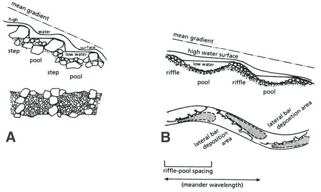
Riffle and Pool Characteristics of High Gradient (A) and Low Gradient (B) Streams. This graphic illustrates the change in deposition characteristics of a stream or river as its gradient decreases. A high-gradient stream (A) has a rapid velocity, often forms falls, and tends to carry away a high volume of all but the largest of particles of potential substrates as they erode from the surrounding landscape. On a low-gradient stream, the loss in water velocity reduces the water column’s ability to transport even the smallest of substrate particles. Deposition of this gravel, sand, silt, and clay forms lateral bars that over time create the familiar meandering path of a naturally flowing lowland stream. (National Park Service image)Benthic substrates in lotic freshwater pools and riffles support an abundance of life forms ranging from colorful diatoms on rocks and cobble, to invertebrates including snails and insect larvae, to fishes like this young Channel Catfish. Free of accumulations of sediment, this river bottom not only provides habitat for a healthy fishery, it facilitates the bidirectional exchange of water between the Susquehanna and its underlying aquifer.On the lower Susquehanna, populations of young Quillback suckers are found almost exclusively in clear, high-gradient pools.The Harlequin Duck winters along the rocky shores and man-made jetties of the Atlantic coast. In summer, they nest on fast-moving, headwater streams well to our north. Very rare on the Susquehanna, this is the first of two individuals found during March and April of 2025. It was observed feeding in the swift waters of the high-gradient riffles and pools where the river cuts through Blue Mountain north of Harrisburg. During previous weeks, Harlequin Ducks were being seen along the coast as far south as the mouth of the Chesapeake at Cape Charles, Virginia. It’s very possible that some of these birds traveled north through the bay area and up the Susquehanna on their way north.
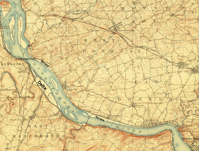
Fluvial Geomorphology of a Stream. Many of the Susquehanna’s tributaries pass through each of these three erosional zones. Along the way, they carry out the process of breaking down the mountains formed by the Allegheny orogeny, the collision of North America and Africa that created the supercontinent Pangea about 325 to 260 million years ago (during portions of both the Carboniferous and Permian periods). Today’s main stem of the lower Susquehanna passes through a transfer zone (Zone 2), carrying eroded materials to a depositional zone (Zone 3) located within the ancient Susquehanna canyon stretching from Havre de Grace, Maryland, to Norfolk Canyon on the edge of the continental shelf. Within this zone, more than a 10,000-year accumulation of post-glacial sediments lies submerged by the rising waters of the Atlantic Ocean and Chesapeake Bay. Although the present-day lower Susquehanna is largely a transfer zone, some deposition occurs along low-gradient segments of the river, particularly where its course parallels the watershed’s ridges both above and below the high-gradient rapids where its path has eroded passage through the highlands. (National Park Service image)Although the present-day lower Susquehanna is largely a transfer zone, some deposition occurs along low-gradient segments of the river, particularly where its course parallels the watershed’s ridges both above and below the high-gradient rapids where its path continues to erode passage through the bedrock. On this 1908 map of the Susquehanna at Conewago Falls, alluvial terraces of gravel, sand, silt, and clay can readily been seen as pale areas nearly lacking brown contour lines along the shorelines and islands of the river. Deposits within most of these terraces date back to the melt period following the most recent glacial event and beyond. The delta shown at the mouth of Conewago Creek (west) includes massive volumes of material deposited by both the creek and the river. This delta is currently known as Brunner Island, much of it developed as the site of a coal/gas-fired electric generating station. Terrace deposits along the Susquehanna’s shorelines created extensive perched marshes and swamps (wooded marshes) fed by rains, high river water, small streams, and springs, the latter often seeping from the base of the rocky escarpments carved by the ancient Susquehanna and defining the present-day inland border of the floodplain. We call these sites “Alluvial Terrace Wetlands”. Few of these critical components of river morphology survive. Those not drained for farmland were obliterated by urbanization and canal, railroad, and highway construction. (United States Geological Survey base image: Middletown, PA, quadrangle, 1908)Water Willow is a familiar emergent plant that colonizes lateral bars and other alluvial deposits in low-gradient segments of the Susquehanna.The fine roots of Water Willow collect sediment and absorb nutrients while creating dense cover for young fish and numerous species of invertebrates including the Virginian River Horn Snails seen here.
Prior to the nineteenth century, the low-gradient flow regime of the river both above and below the riffles at Chiques Rock (lower right on map) created prime wildlife habitat. The natural accumulations of nutrients and substrates carried into and through the lotic waterway’s pools and riffles were cycled into an ideal growing medium for extensive mats of American Eelgrass and other aquatic plants. This underwater forest hosted a seemingly endless abundance of invertebrates and fishes (both resident and migratory)—supporting a variety of consumer species including various populations of humans. But soon after the mass clearing of much of the watershed’s land for farming and lumber, the mill ponds created by dams constructed on streams to power saw and grain mills became brimful with sediments eroded from the unprotected ground. During storm events, torrents of these sediments then flowed full bore toward the Susquehanna, and began accumulating in the low-gradient segments of the river.
Sediments left behind after the removal of mill dams are known as legacy sediments. They disconnect the stream from its historic floodplain and riverine (fluvial) wetlands, thus intensifying the impact of high water in the surrounding landscape. As these nutrient-charged deposits wash away, they become a source of pollution in the waters of the Susquehanna and Chesapeake.A mat of American Eelgrass growing in the flowing waters of the Susquehanna below Conewago Falls. Eelgrass and other submerged aquatic plants provide essential habitat for a wide variety of small fish and invertebrates while also consuming nutrients deposited in the cobble, gravel, and sand substrate of the river’s pools. Excess quantities of smaller particles of silt and clay can clog the substrate and thus inhibit the hyporheic exchange of water between the stream channel and the underlying aquifer, often diminishing the biomass and diversity of organisms inhabiting this benthic habitat. Buried in these life-choking sediments, the river bottom becomes inhospitable to growth of submerged aquatics including eelgrass.This low-gradient stretch of the Susquehanna at Marietta flows parallel to the Chickies Quartzite “Hellam Hills” before making a sharp right turn to punch through the ridge as a series of rapids at Chiques Rock. Formerly a fully functional lotic ecosystem and a paradise for migrating waterfowl, this river segment is now impaired by accumulations of nutrient-laden sediments from agricultural and urban runoff.Nutrient and sediment-loaded flood waters roar across the diabase boulders at the York Haven Dam and Conewago Falls, a high-gradient segment of the Susquehanna.They continue past Brunner Island (left power plant stacks) and through Haldeman Riffles and the Shocks Mills Railroad Bridge……into the stretch of river known as the “Marietta broads” along the base of the Chickies Quartzite “Hellam Hills”. The low stream gradient here produces a slower current and increased deposition of sediments.As the flood surges through the riffle and pool complex at Chiques Rock, the high stream gradient maintains a velocity in the water column sufficient to keep additional sediments in suspension until they reach the low-gradient river segment just downstream at Washington Boro, site of a naturally occurring lateral bar area known as the Conejohela Flats. These bars now lie within the man-made depositional zone known as “Lake Clarke”. Created nearly a century ago by construction of the Safe Harbor Dam, this impoundment is accumulating astounding volumes of nutrient-loaded sediments that continue to encapsulate the flats within a stream-impairing delta.Anytime from November to April on the lower Susquehanna, a group of Redheads, Canvasbacks (3 birds to right of the middle of the picture), and a Horned Grebe (lower left) is a welcome sight in a riverine pool known to have a summertime growth of American Eelgrass. Noted Dr. Herbert Beck in 1924 when describing the Canvasback, “Like all ducks, …, it stops to feed within the county (Lancaster) less frequently than formerly, principally because the vast beds of wild celery which existed earlier on broads of the Susquehanna, as at Marietta and Washington Borough, have now been almost entirely wiped out by sedimentation of culm. Prior to 1875 the four or five square miles of quiet water off Marietta were often as abundantly spread with wild fowl as the Susquehanna Flats are now. Sometimes there were as many as 500,000 ducks of various kinds on the Marietta broad at one time.”Today, seeing just dozens of Aythya genus ducks (Redheads, Canvasbacks, scaup) on the lower Susquehanna is a notable event. If they happen to be forced down by inclement weather while migrating through, you might get lucky enough to see several hundred.While the recovery of eelgrass/wild celery beds on the Susquehanna is trivial in scale and offers little support for numbers of waterfowl to return to historic levels, restorations on the upper Chesapeake in the vicinity of the Susquehanna Flats between Havre de Grace and Aberdeen Proving Grounds may have helped refuel a gathering of mostly Aythya genus ducks during the final days of February. This mass of ducks, many of which were forced south from the frozen Great Lakes during the previous weeks (some by way of the ice-choked Susquehanna) were apparently making an abrupt turn to make their way back north. Their stay was brief, but estimates by local birders put their numbers as high as one half million. The vast majority of the concentration consisted of Aythya species: Redheads, Canvasbacks, Ring-necked Ducks, and both Lesser and Greater Scaup. It probably included a mix of birds including both northbound migrants from further down the coast and the aforementioned refugees that had just arrived to pay a quick visit while escaping the late-season ice before turning around.During the past two centuries, as food supplies in the Susquehanna grew increasingly compromised for benthic feeders like these Lesser Scaup and other diving ducks, a change in distribution was necessary for survival.As individual species, Lesser Scaup and other waterfowl that fail to adapt to natural or man-made changes in their habitats and food supplies may see their overall global numbers falter.
Despite being located in the transfer zone, the lower Susquehanna has become a significant depositional zone along much of its length, mostly courtesy of the placement of sediment-trapping man-made dams.
Following construction of the mill dams and ponds on nearly every mile of the lower Susquehanna’s low-gradient tributary streams, enterprising parties moved on to the river. The first significant spans were constructed using wide timber cribs filled with large rock. They were placed to create water deep enough to allow canal boats to cross the Susquehanna at both Clark’s Ferry at the mouth of the Juniata River in Dauphin County and at Columbia/Wrightsville. These dams also diverted water into the newly excavated canals—the Pennsylvania Eastern Division Canal (completed in 1833) which followed the river’s east shore from Clark’s Ferry to Columbia, and the Susquehanna and Tidewater Canal (completed in 1840) along the west shore from Wrightsville to Havre de Grace, Maryland. Placement of these sediment-trapping man-made dams began a process of converting vast mileage of the lower Susquehanna from a transfer zone into a deposition zone. In addition, layout of the canals and locks followed the contours along the base of the riverside ridges, seriously altering most of the alluvial terrace wetlands that the river had created as a feature of its floodplain during the post-glacial period.
Construction of the canal dams was just the beginning. During the twentieth century, more massive dams would be added to the main stem of the river for hydroelectric energy production at York Haven, Safe Harbor, Holtwood, and Conowingo. Upon their completion, the days of unassisted anadromous fish migrations were over. On both the river and its tributaries, smaller dams including dangerous low-head dams maintain water levels for boating and recreation. They too create current-diminishing, pseudo-lentic waters that blanket the lotic riffle and pool substrates with polluted sediments.
MAN-MADE DAMS TURN LOTIC WATERS INTO UNFLUSHED TOILETS
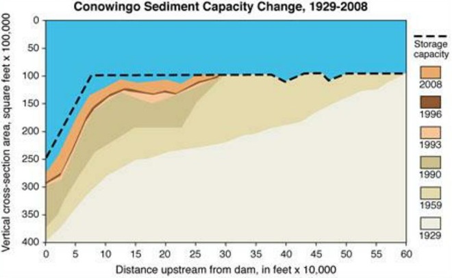
The construction of dams on the lower Susquehanna has converted vast mileage of the river from a lotic freshwater system into a series of man-made lentic freshwater lakes. These areas have lost their function as a lotic transfer zone and are now a sort of dysfunctional series of depositional zones collecting vast volumes of sediment containing nutrients and other pollutants. Within each impoundment, the reduced velocity of the river causes it to drop suspended sand first, then the finer particles of silt and clay closer to the dam. The flow regime of riffles and pools is lost and the hyporheic zone that exchanges water between the river and the underlying aquifer is clogged. These impaired segments of river become ripe for eutrophication: algal blooms followed by die offs that can lead to a fatal reduction of dissolved oxygen in the water column.Deposits of lateral bars of sediment in low-gradient segments of the Susquehanna can create shallow water feeding habitat for puddle/dabbling ducks like these Gadwall. Where sediment pollution is severe, benthic foods in these areas often consist mostly of invertebrates and plant matter deposited by the current, the buried substrates devoid of a functioning ecosystem and the waters subject to eutrophication.Common Goldeneyes on a patch of open water on an otherwise ice-covered “Lake Clarke”, the impoundment created by Safe Harbor Dam. While they may find this spot advantageous for loafing, the food supply over the sediment-buried substrate will be limited.By the end of the twentieth century, accumulations of polluted sediments behind lower Susquehanna dams were nearing capacity. There is no working plan to attenuate the massive release of these pollutants that may be triggered by a catastrophic flood. The effort to reduce nutrient and sediment runoff remains the focus so that new loading is kept to a minimum and won’t add to the capacity problems at the dams or continue downriver to the Chesapeake at full strength when the dams are full. Alleviating the sediment aggregation problem within the river’s impoundments is a tall order and a dilemma not easily solved. (United States Geological Survey image)Common Mergansers will feed where benthic substrate supports the small fish and invertebrates they prefer. They will, however, gather in extraordinary numbers on the “lakes” created by riverine dams. Though they can only feed on what floats in with the current, hundreds or sometimes thousands of Common Mergansers will concentrate on “Conowingo Pond” during the late fall or early winter. There, safety in numbers gives them some guarantee of protection against the multitudes of eagles that simultaneously frequent the vicinity. Another advantage of staging on “Conowingo Pond” is its close proximity to favorable feeding areas on upper Chesapeake Bay and stretches of the Susquehanna where lotic riffles and pools offer abundant opportunities below the river’s dams.Fortunately for everything else living in the benthos, Common Mergansers are big enough to devour invasive, non-native Rusty Crayfish when they find them in our lotic waterways.
TIME TO CLEAN UP OUR ACT
WHERE DOES YOUR STORMWATER GO?
Channelized Urban/Suburban Streams Function as Sewers. They have no attached lowlands or floodplains to absorb, purify, and infiltrate runoff from rain events. Pollutants including litter, pet waste, lawn chemicals, tire-wear particles, hazardous fluids, and sometimes untreated human excrement flush unchecked from the municipal storm drainage system into the waterway. Thermal shock from summer downpours washing across sun-heated pavements can kill temperature sensitive fishes and other aquatic life. Nutrient and sediment loads from these impaired tributaries later accumulate downstream in low-gradient segments of the Susquehanna, turning the river into an open-air cesspool. Aggressively working to implement projects that eliminate these sources of pollution are the only effective way to keep the problem from getting worse. Making things better requires a lot more dedication and effort. (United States Geological Survey image by Frank Ippolito)
RIPARIAN BUFFERS MAKE A DIFFERENCE…WIDER IS BETTER
To sequester sediment and cycle nutrients (primarily nitrogen and phosphorus) contained in farm runoff, the U.S.D.A. recommends installing riparian buffers between streams and lands used for grazing and raising crops. To protect pollinating species including bees and butterflies from pesticide drift and eroding soils rich in fertilizers, they further recommend installing a stand of wind-pollinating plants such as conifers, oaks, and birches between the field and streamside plantings. These same conservation practices improve water quality and wildlife habitat on waterways located in residential and commercial areas as well. (United States Department of Agriculture image, click to enlarge)
FLOODPLAIN RESTORATION
Regardless OF HOW LONG YOU’VE BEEN CONDITIONED TO THINK OTHERWISE, THIS IS A DYSFUNCTIONAL, POLLUTED CREEK—AND IT NEEDS HELP
A channelized low-gradient stream eroding a path through deposits of legacy sediments displaces flood waters into previously unaffected areas and provides a continuing source of nutrient and sediment pollution during storm events. These impaired waters have a diminished capacity for supporting aquatic life including fishes.
RESTORED TO ITS HISTORIC FUNCTIONS
On an adjacent segment of the same creek, this legacy sediment removal project restored a braided meandering channel and connected it to its newly liberated, historic floodplain. In just their second year, the fluvial wetlands are effectively absorbing stormwater and sequestering nutrients as an attached component of the stream’s riffle and pool complex. During our visit earlier this week, we found American Toads, Northern Leopard Frogs (Lithobates pipiens), and Northern Spring Peepers breeding here. It’s just as Castor canadensis would have it!
“STOP HEMMING AND HAWING AROUND ALREADY”
“HEY COWBOY, HOW ‘BOUT GETTIN’ THEM FILTHY LITTLE DOGIES OUTTA DAT CRICK?”
Here’s a polluted stream in a pasture with grazing livestock. The site is a former mill pond within which the creek eroded a channel following removal of the dam. The animals defecate and urinate where access to water is gained at a broken down embankment of the nutrient-loaded legacy sediments deposited in the pond more than a century ago. It’s a haphazard form of animal husbandry and a reminder that all it takes is just one stubborn jackass to foul up the whole waterway.
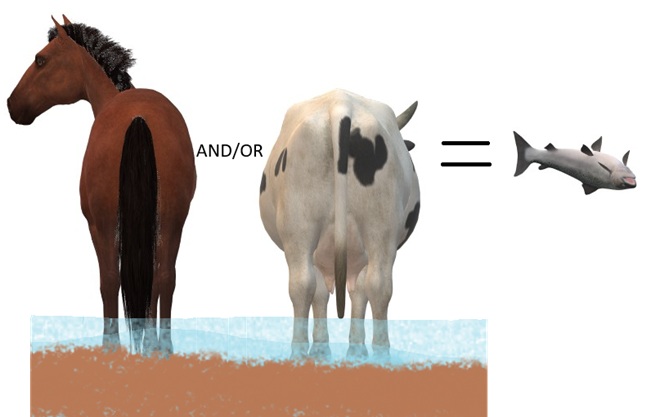
DIRECT SOURCES OF NITROGEN (AMMONIA) POLLUTION IN STREAMS
DID YOU KNOW that a dairy cow produces about 80 pounds of waste (excrement and urine) every day?
DID YOU KNOW that a horse produces about 50 pounds of waste (excrement and urine) every day?
DID YOU KNOW that a human produces about 3 to 4 pounds of waste (excrement and urine) every day? The exceptions, of course, are those who continue to insist that raising farm animals in and alongside a body of water is okey-doke—a harmless practice. These individuals tend to retain the former constituent of human waste and are thus full of it.
“ATTABOY TEX, THAT’S MORE LIKE IT!”
Now that’s better. Legacy sediments have been removed to reconnect the stream to its floodplain. A livestock crossing and exclusion fencing has been installed, and a nutrient-consuming riparian buffer has been planted. This creek segment’s pollution woes have been mitigated. Do you have a neighbor needing this type of remedial work on their farm? Encourage them to contact your local county conservation district office or volunteer waterways restoration organization for assistance. Various programs provide financial assistance covering all or most of the costs of stream improvement as well as monetary incentives for helping to clean up the water.
AND FINALLY
WHEN IT COMES TO BUILDING DAMS ON LOTIC FRESH WATERS…
…LEAVE IT TO THE BEAVERS
North American Beavers (Castor canadensis) create habitats that connect the riffle and pool regime of a low-gradient stream to a surrounding fluvial wetland that retains sediments, cycles nutrients, and provides essential habitat for hundreds of plant and animal species. Floodplains are for flooding, and if a beaver floods an area, you can be guaranteed that it was already part of a floodplain. You see, beavers don’t encroach upon humans, it’s humans engaging in the encroachment upon beavers. (National Park Service image)
MAD HATTERS
DID YOU KNOW that even before the landscape was cleared for farms and a supply of timber, and before mill dams on local creeks began accumulating soil runoff from the consequently barren hillsides, all the North American Beavers, the keystone species of lower Susquehanna stream ecology, were killed and sold to make hats? It’s no wonder things are fubar!
COMING SOON…
Horned Grebes are regular migrants and sometimes winter residents on ice-free stretches of the lower Susquehanna. They spend their time plying the benthic substrate of the river’s clear riffles and pools for a variety of invertebrates and small fish. Look for them moving north in coming days sporting this beautiful breeding plumage.April and early May are prime time for observing Common Loons on the Susquehanna as they undertake a journey from the Atlantic surf where they spent the winter to nesting sites on northern lakes. For this migrant in breeding plumage, clear water for sighting plenty of benthic life in the river’s riffles and pools assures a successful dive in search of energy-replenishing forage.


")