County Conservation District Tree Sales are underway throughout the Lower Susquehanna River Watershed. Now is the time to order for pickup in April. The prices are a bargain and the selection is fabulous. For species descriptions and more details, visit each tree sale web page (click the sale name highlighted in blue). And don’t forget to order bundles of evergreens for planting in mixed clumps and groves to provide winter shelter and summertime nesting sites for our local birds. They’re only $12.00 for a bundle of 10—can’t beat that deal!
Pickup on: Thursday, April 20, 2023 or Friday, April 21, 2023
Don’t mow it. Plant a meadow or pollinator garden instead.Both Cumberland and Perry Counties are offering a native warm-season grass and wildflower seed mix for planting your own meadow or pollinator garden. Perry County is also taking orders for a seed mix specifically formulated to grow plants for attracting hummingbirds and butterflies.
Pickup on: Thursday, April 20, 2023 or Friday, April 21, 2023
The Eastern Hemlock, Pennsylvania’s official state tree, is an excellent choice for addition to your landscape or reforestation project. It tolerates rocky soils and its cones are an prime source of food for birds ranging from chickadees to finches.
The handsome yet underused Northern Red Oak is a sturdy long-lived native tree that is ideal for street-side, lawn, and reforestation plantings. In spring, it can be a magnet for migrating Neotropical birds when its flowers attract a wide variety of tiny insects to its upper reaches. Unlike many other oaks, this species is a relatively fast grower.
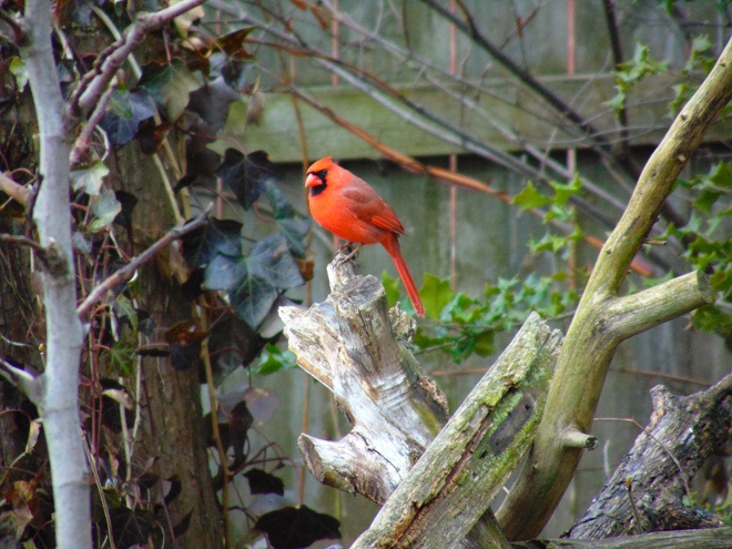
In autumn, even after the bright red foliage is gone, the berries of mature Black Gum (Nyssa sylvatica) trees attract a wide variety of birds like this Pileated Woodpecker. The Lebanon County Conservation District is offering Black Gum, also known as Black Tupelo, during their 2023 tree sale. Why not order and plant a half dozen or more?
The Perry County Conservation District is not only offering plants during this year’s sale, you can also purchase bluebird nest boxes for just $12.00 each!For less than the cost of one year of mowing, this stream corridor in Conewago Township, Dauphin County was reforested by the owner with hundreds of native trees, the majority purchased through County Conservation District Tree Sale events spanning a period of several years. By replacing bare soil and mowed areas, the riparian buffer created by these plantings has significantly reduced the nutrient and sediment loads that were polluting the small stream therein known as Brill’s Run. With determination and not a lot of money, you can do it too.But don’t forget the Eastern White Pines!
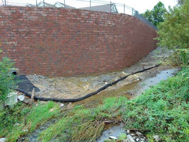
This stream restoration project is currently underway along a one-mile-long segment of Lancaster Conservancy lands along Conewago Creek. The mountain of dirt is one of several stockpiles of legacy sediments removed to reestablish the floodplain’s historic geomorphology. After eroding from cropland during the years prior to soil conservation, legacy sediments accumulated behind mill dams on waterways throughout the lower Susquehanna watershed. After removal of the dams, creeks were left trapped within the sediment-choked bottomlands, incising steep muddy banks as they cut a new path through the former mill ponds. Excavating legacy sediments from these sites eliminates creek banks and allows floodwaters to again spill directly into wetlands along the stream course. With floodplain and wetland functions restored, nutrients are sequestered, high water is infiltrated to recharge aquifers, sediment loads from collapsing banks are eliminated, and much-needed habitat is created for native plants and animals.
To learn more about this project and others, you’ll want to check out the LandStudies website.
At this very moment, your editor is comfortably numb and is, if everything is going according to plans, again having a snake run through the plumbing in his body’s most important muscle. It thus occurs to him how strange it is that with muscles as run down and faulty as his, people at one time asked him to come speak about and display his marvelous mussels. And some, believe it or not, actually took interest in such a thing. If the reader finds this odd, he or she would not be alone. But the peculiarities don’t stop there. The reader may find further bewilderment after being informed that the editor’s mussels are now in the collection of a regional museum where they are preserved for study by qualified persons with scientific proclivities. All of this show and tell was for just one purpose—to raise appreciation and sentiment for our mussels, so that they might be protected.
Click on the “Freshwater Mussels and Clams” tab at the top of this page to see the editor’s mussels, and many others as well. Then maybe you too will want to flex your muscles for our mussels. They really do need, and deserve, our help.
As deciduous trees lose their foliage in coming days, it’s an excellent time to pick up and examine some samples from the species you encounter during your autumn strolls. Uncle Tyler Dyer is assembling the leaves he finds into a guide for identifying the most common wild and naturalized trees, shrubs, and woody vines of the Lower Susquehanna River Watershed. To use it, click on the “Trees, Shrubs, and Woody Vines” tab at the top of this page and check out…
Click this image to visit “Ty Dyer’s Kaleidoscope of Color”.
…better known as Uncle Tyler’s leaf collection.
Thinking about doing some planting on your property during the fall or in the spring? Before you do, peruse the gorgeous colors offered by the native species shown on Uncle Ty’s page. You might never go back to those short-lived high maintenance cultivars of imported species ever again. And by choosing a variety of native plants, you’ll be helping wildlife too.
Oh, by the way—thanks Uncle Ty. Yes, it is far out!
Submersed aquatic plants in streams, lakes, ponds, bays, and estuaries do more than take up nutrients and provide habitat for fish and other organisms, they produce oxygen during photosynthesis. Here we see tapegrass (Vallisneria) in bright sunlight releasing a visible string of oxygen bubbles, an emission known as “pearling”. British chemist, theologian, and philosopher Joseph Priestly (1733-1804), who spent his final decade residing along the Susquehanna in Northumberland, Pennsylvania, isolated oxygen during experiments in 1774 by exposing mercuric oxide to direct sunlight. During the following year, Priestly published his findings in “An Account of Further Discoveries in Air”, describing what he called “dephlogisticated air”, the gas later named oxygen. To observe and record the effects of pure oxygen in the absence of atmospheric air, Priestly first tested it on a mouse, then breathed it himself.
The Pennsylvania Department of Environmental Protection has issued a “drought watch” for much of the state’s Susquehanna basin including Dauphin, Lebanon, and Perry Counties—plus those counties to their north. Residents are asked to conserve water in the affected areas.
Water conservation measures are voluntary during a drought watch, and most consumers try to cut back on nonessential use. For many though, threats to water supply and water quality generate little concern. This evening, on this farm along a Dauphin County waterway undergoing restoration, we shouldn’t be too surprised to see lots of water being pumped from the creek to soak down liquid manure that was spread on the fields earlier in the week. This happens to be the only property along a five-mile segment of stream that still allows cattle and draft horses to wade, defecate, and urinate in the water. It is the only parcel for nearly seven miles that has eroding banks of legacy sediments that are maintained denuded of nearly all vegetation. Despite some beneficial practices like the use of cover crops, it’s a polluter. And now its operator appears to be engaged in something new: “stream dewatering”. With three irrigation guns in operation, this farmer was easily pumping and removing up to one half or more of the creek’s flow, which at the time, according to a United States Geological Survey gauge less than a mile upstream, was only about 3 cubic feet per second or 1,100 gallons per minute (G.P.M.). That doesn’t let much for the municipalities downstream that rely upon this waterway as a supplemental source of drinking water, does it? Such a large reduction in base flow can threaten the survival of fish and other aquatic inhabitants in the creek, particular during hot summer weather when dissolved oxygen levels can be at their lowest of the year. Water is like a lot of other necessities, no one really gives it a second thought until they don’t have it; and as long as I have mine, that’s all that really matters.
The fruits of a Black Chokeberry (Aronia melanocarpa) prove irresistible to this Gray Catbird. Chokeberry is a native clump-forming shrub that reaches a height of less than ten feet. It is tolerant of wet soils and makes a good choice for inclusion in plantings alongside streams and ponds, as well as in rain gardens. Springtime clusters of white flowers yield berries by this time each summer. By turning red as the fruits ripen, the foliage helps attract not only catbirds, but robins, waxwings, and other species that, in exchange for a meal, will assure dispersal of the plant’s seeds in their droppings. With considerable sweetening, tart chokeberries can be used for juicing and the creation of jams, jellies, and preserves.
This tallgrass prairie wildflower planting on a health campus in Hershey, Pennsylvania, enhances stormwater management and benefits butterflies and other wildlife. Reducing the acreage maintained as manicured lawn has helped disperse the large flocks of resident Canada Geese (a population of invasive native transplants) that frequented the property and posed a serious hazard to medevac helicopters flying in and out of the facility.Big Bluestem, a warm-season grass, dominates the site and is complemented by Indiangrass and tall wildflowers including Common Milkweed, Wild Bergamot, Oxeye, Black-eyed Susan, Prairie Coneflower, and Purple Coneflower.
This month, the International Union for Conservation of Nature (I.U.C.N.) added the Migratory Monarch Butterfly (Danaus plexippus plexippus) to its “Red List of Threatened Species”, classifying it as endangered. Perhaps there is no better time than the present to have a look at the virtues of replacing areas of mowed and manicured grass with a wildflower garden or meadow that provides essential breeding and feeding habitat for Monarchs and hundreds of other species of animals.
A recently arrived Monarch visits a cluster of fragrant Common Milkweed flowers in the garden at the susquehannawildlife.net headquarters. Milkweeds included among a wide variety of plants in a garden or meadow habitat can help local populations of Monarchs increase their numbers before the autumn flights to wintering grounds commence in the fall. Female Monarchs lay their eggs on milkweed leaves, then, after hatching, the larvae (caterpillars) feed on them before pupating.
If you’re not quite sure about finally breaking the ties that bind you to the cult of lawn manicuring, then compare the attributes of a parcel maintained as mowed grass with those of a space planted as a wildflower garden or meadow. In our example we’ve mixed native warm season grasses with the wildflowers and thrown in a couple of Eastern Red Cedars to create a more authentic early successional habitat.
* Particularly when native warm-season grasses are included (root depth 6′-8′)
Still not ready to take the leap. Think about this: once established, the wildflower planting can be maintained without the use of herbicides or insecticides. There’ll be no pesticide residues leaching into the soil or running off during downpours. Yes friends, it doesn’t matter whether you’re using a private well or a community system, a wildflower meadow is an asset to your water supply. Not only is it free of man-made chemicals, but it also provides stormwater retention to recharge the aquifer by holding precipitation on site and guiding it into the ground. Mowed grass on the other hand, particularly when situated on steep slopes or when the ground is frozen or dry, does little to stop or slow the sheet runoff that floods and pollutes streams during heavy rains.
What if I told you that for less than fifty bucks, you could start a wildflower garden covering 1,000 square feet of space? That’s a nice plot 25′ x 40′ or a strip 10′ wide and 100′ long along a driveway, field margin, roadside, property line, swale, or stream. All you need to do is cast seed evenly across bare soil in a sunny location and you’ll soon have a spectacular wildflower garden. Here at the susquehannawildllife.net headquarters we don’t have that much space, so we just cast the seed along the margins of the driveway and around established trees and shrubs. Look what we get for pennies a plant…
Some of the wildflowers and warm-season grasses grown from scattered seed in the susquehannawildlife.net headquarters garden.
Here’s a closer look…
Lance-leaved Coreopsis (Coreopsis lanceolata), a perennial.Black-eyed Susan, a biennial or short-lived perennial.“Gloriosa Daisy”, a variety of Black-eyed Susan, a biennial or short-lived perennial.Purple Coneflower, an excellent perennial for pollinators. The ripe seeds provide food for American Goldfinches.A short variety of Common Sunflower, an annual and a source of free bird seed.Another short variety of Common Sunflower, an annual.
All this and best of all, we never need to mow.
Around the garden, we’ve used a northeast wildflower mix from American Meadows. It’s a blend of annuals and perennials that’s easy to grow. On their website, you’ll find seeds for individual species as well as mixes and instructions for planting and maintaining your wildflower garden. They even have a mix specifically formulated for hummingbirds and butterflies.
When planted in spring and early summer, annuals included in a wildflower mix will provide vibrant color during the first year. Many varieties will self-seed to supplement the display provided by biennials and perennials in subsequent years.A northeast wildflower mix from American Meadows. There are no fillers. One pound of pure live seed easily plants 1,000 square feet.
Nothing does more to promote the spread and abundance of non-native plants, including invasive species, than repetitive mowing. One of the big advantages of planting a wildflower garden or meadow is the opportunity to promote the growth of a community of diverse native plants on your property. A single mowing is done only during the dormant season to reseed annuals and to maintain the meadow in an early successional stage—preventing reversion to forest.
For wildflower mixes containing native species, including ecotypes from locations in and near the Lower Susquehanna River Watershed, nobody beats Ernst Conservation Seeds of Meadville, Pennsylvania. Their selection of grass and wildflower seed mixes could keep you planting new projects for a lifetime. They craft blends for specific regions, states, physiographic provinces, habitats, soils, and uses. Check out these examples of some of the scores of mixes offered at Ernst Conservation Seeds…
Pipeline Mixes
Pasture, Grazing, and Hay Mixes
Cover Crops
Pondside Mixes
Warm-season Grass Mixes
Retention Basin Mixes
Wildlife Mixes
Pollinator Mixes
Wetland Mixes
Floodplain and Riparian Buffer Mixes
Rain Garden Mixes
Steep Slope Mixes
Solar Farm Mixes
Strip Mine Reclamation Mixes
We’ve used their “Showy Northeast Native Wildflower and Grass Mix” on streambank renewal projects with great success. For Monarchs, we really recommend the “Butterfly and Hummingbird Garden Mix”. It includes many of the species pictured above plus “Fort Indiantown Gap” Little Bluestem, a warm-season grass native to Lebanon County, Pennsylvania, and milkweeds (Asclepias), which are not included in their northeast native wildflower blends. More than a dozen of the flowers and grasses currently included in this mix are derived from Pennsylvania ecotypes, so you can expect them to thrive in the Lower Susquehanna River Watershed.
Swamp Milkweed, a perennial species, is included in the Ernst Seed “Butterfly and Hummingbird Garden Mix”. It is a favorite of female Monarchs seeking a location to deposit eggs.A Monarch larva (caterpillar) feeding on Swamp Milkweed.Butterfly Weed (Asclepias tuberosa) is included in the Ernst Seed “Butterfly and Hummingbird Garden Mix”. This perennial is also known as Butterfly Milkweed.Eastern Tiger Swallowtails are among the dozens of species of pollinators that will visit Butterfly Weed.
In addition to the milkweeds, you’ll find these attractive plants included in Ernst Conservation Seed’s “Butterfly and Hummingbird Garden Mix”, as well as in some of their other blends.
The perennial Wild Bergamot, also known as Bee Balm, is an excellent pollinator plant, and the tubular flowers are a favorite of hummingbirds.Oxeye is adorned with showy clusters of sunflower-like blooms in mid-summer. It is a perennial plant.Plains Coreopsis (Coreopsis tinctoria), also known as Plains Tickseed, is a versatile annual that can survive occasional flooding as well as drought.Gray-headed Coneflower (Ratibida pinnata), a tall perennial, is spectacular during its long flowering season.Goldenrods are a favorite nectar plant for migrating Monarchs in autumn. They seldom need to be sown into a wildflower garden; the seeds of local species usually arrive on the wind. They are included in the “Butterfly and Hummingbird Garden Mix” from Ernst Conservation Seeds in low dose, just in case the wind doesn’t bring anything your way.Is something missing from your seed mix? You can purchase individual species from the selections available at American Meadows and Ernst Conservation Seeds. Partridge Pea is a good native annual to add. It is a host plant for the Cloudless Sulphur butterfly and hummingbirds will often visit the flowers. It does really well in sandy soils.Indiangrass is a warm-season species that makes a great addition to any wildflower meadow mix. Its deep roots make it resistant to drought and ideal for preventing erosion.
Why not give the Monarchs and other wildlife living around you a little help? Plant a wildflower garden or meadow. It’s so easy, a child can do it.
Volunteers sow a riparian buffer on a recontoured stream bank using wildflower and warm-season grass seed blended uniformly with sand. By casting the sand/seed mixture evenly over the planting site, participants can visually assure that seed has been distributed according to the space calculations.The same seeded site less than four months later.A Monarch pupa from which the adult butterfly will emerge.
On these hot and steamy days of summer, I get to thinking about how great it would be to have a swimming pool. Maybe I would take a little dip, you know, just to cool down. But when I really get to thinking about it, I just might do what the professor has done with his pool.
Is it the latest image from NASA’s new Webb Space Telescope? Nope, it’s the globular flower cluster of the Buttonbush, a native shrub species found throughout the Lower Susquehanna River Watershed. Buttonbush thrives in wet soil and seldom grows taller than 10 feet in height. Try it along stream banks, in stormwater retention basins, and in rain gardens fed by surface runoff or the outflow from your downspouts.
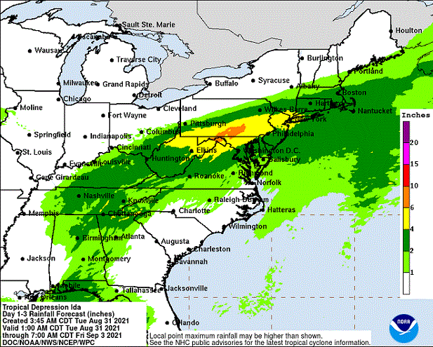
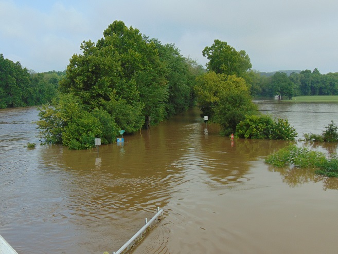
The remnants of Hurricane Ida are on their way to the Lower Susquehanna River Watershed. After making landfall in Louisiana as a category 4 storm, Ida is on track to bring heavy rain to the Mid-Atlantic States beginning tonight.
Tropical Depression Ida moving slowly toward the northeast. (NOAA/GOES image)
Rainfall totals are anticipated to be sufficient to cause flooding in the lower Susquehanna basin. As much as six to ten inches of precipitation could fall in parts of the area on Wednesday.
Rainfall forecasts from the National Hurricane Center. (NOAA/National Hurricane Center image)
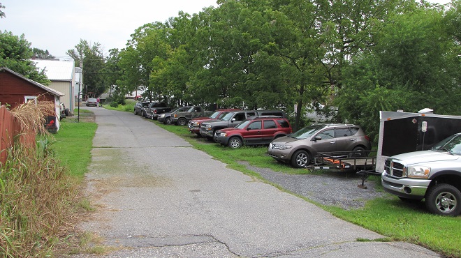
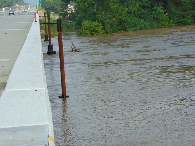
Now would be a good time to get all your valuables and junk out of the floodways and floodplains. Move your cars, trucks, S.U.V.s, trailers, and boats to higher ground. Clear out the trash cans, playground equipment, picnic tables, and lawn furniture too. Get it all to higher ground. Don’t be the slob who uses a flood as a chance to get rid of tires and other rubbish by letting it just wash away.
Vehicles parked atop fill that has been dumped into a stream’s floodplain are in double trouble. Fill displaces water and exasperates flooding instead of providing refuge from it. Better move these cars, trucks, and trailers to higher ground, posthaste.
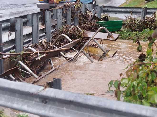
Flooding not only has economic and public safety impacts, it is a source of enormous amounts of pollution. Chemical spills from inundated homes, businesses, and vehicles combine with nutrient and sediment runoff from eroding fields to create a filthy brown torrent that rushes down stream courses and into the Susquehanna. Failed and flooded sewage facilities, both municipal and private, not only pollute the water, but give it that foul odor familiar to those who visit the shores of the river after a major storm. And of course there is the garbage. The tons and tons of waste that people discard carelessly that, during a flood event, finds its way ever closer to the Susquehanna, then the Chesapeake, and finally the Atlantic. It’s a disgraceful legacy.
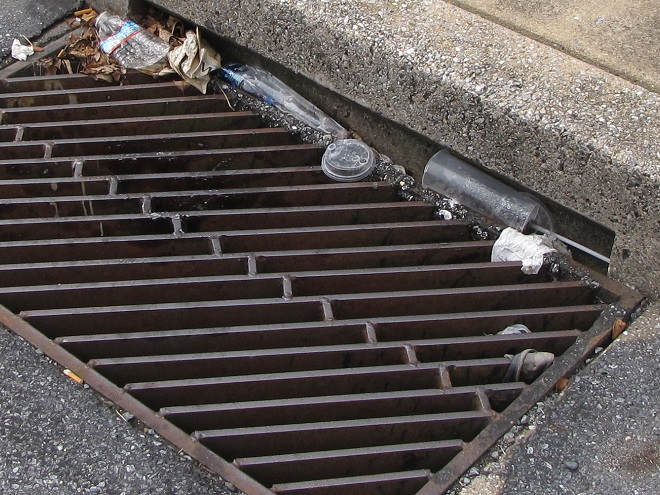
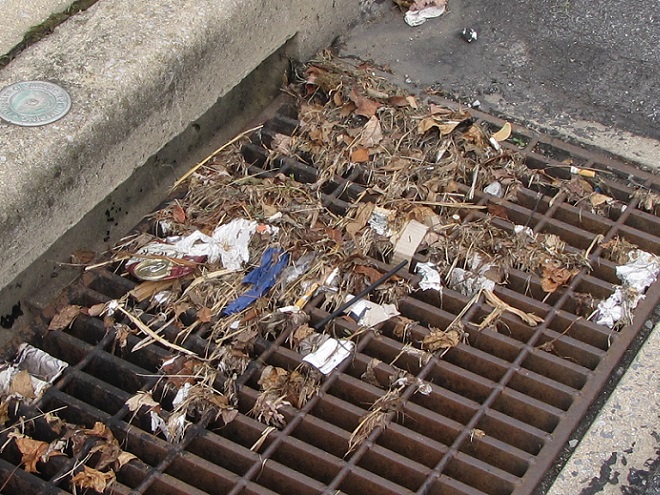
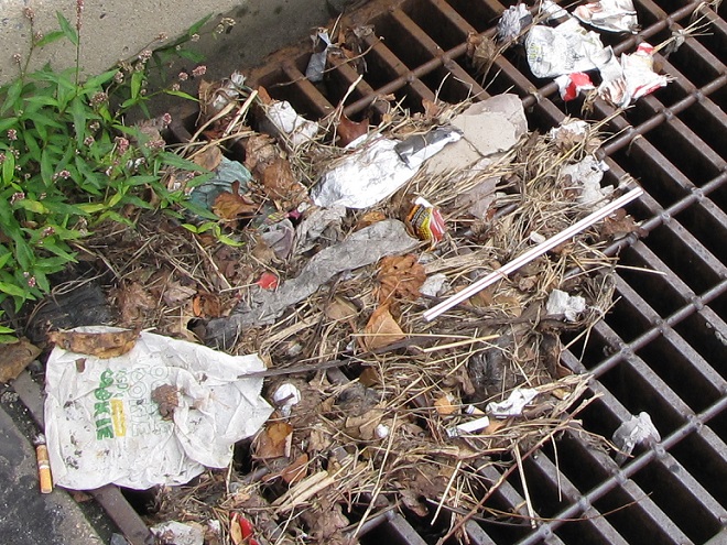
Now is your chance to do something about it. Go out right now and pick up the trash along the curb, in the street, and on the sidewalk and lawn—before it gets swept into your nearby stormwater inlet or stream. It’s easy to do, just bend and stoop. While you’re at it, clean up the driveway and parking lot too.
Secure your trash and pick up litter before it finds its way into the storm sewer system and eventually your local stream. It’ll take just a minute.This is how straws and other plastics find their way to the ocean and the marine animals living there, so pick that stuff up! Did you know that keeping stormwater inlets clean can prevent street flooding and its destructive extension into the cellars of nearby homes and businesses?There’s another straw. Pick it and the rest of that junk up now, before the storm. Don’t wait for your local municipality or the Boy Scouts to do it. You do it, even if it’s not your trash.
We’ll be checking to see how you did.
And remember, flood plains are for flooding, so get out of the floodplain and stay out.
Thoughts of October in the Lower Susquehanna River Watershed bring to mind scenes of brilliant fall foliage adorning wooded hillsides and stream courses, frosty mornings bringing an end to the growing season, and geese and other birds flying south for the winter.
The autumn migration of birds spans a period equaling nearly half the calendar year. Shorebirds and Neotropical perching birds begin moving through as early as late July, just as daylight hours begin decreasing during the weeks following their peak at summer solstice in late June. During the darkest days of the year, those surrounding winter solstice in late December, the last of the southbound migrants, including some hawks, eagles, waterfowl, and gulls, may still be on the move.
The Rough-legged Hawk (Buteo lagopus), a rodent-eating raptor of tundra, grassland, and marsh, is rare as a migrant and winter resident in the lower Susquehanna valley. It may arrive as late as January, if at all.
During October, there is a distinct change in the list of species an observer might find migrating through the lower Susquehanna valley. Reduced hours of daylight and plunges in temperatures—particularly frost and freeze events—impact the food sources available to birds. It is during October that we say goodbye to the Neotropical migrants and hello to those more hardy species that spend their winters in temperate climates like ours.
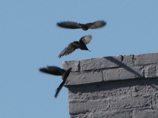
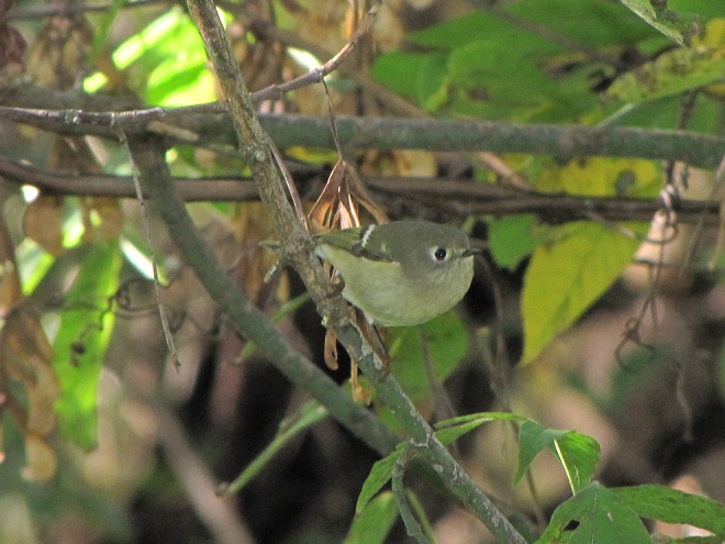
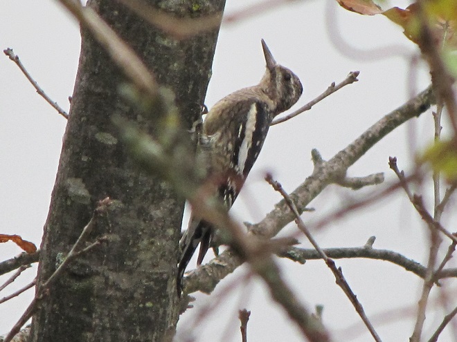
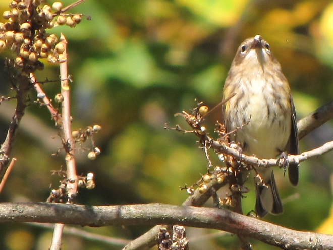
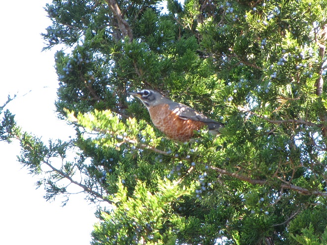
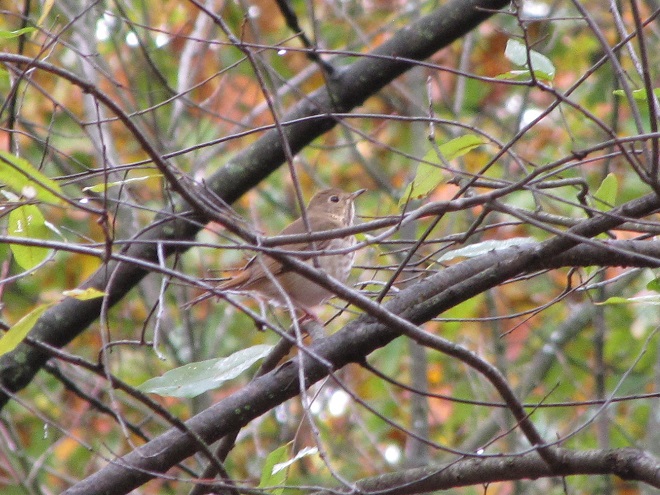
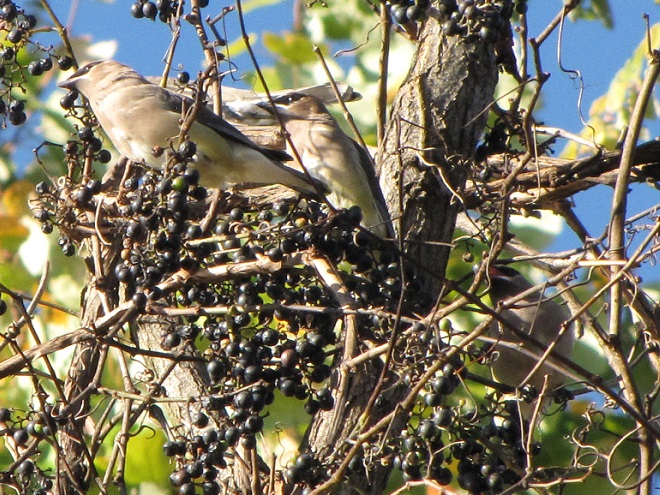
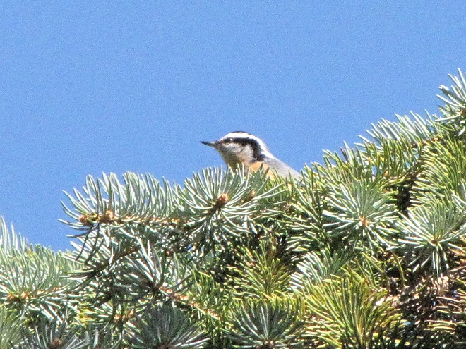
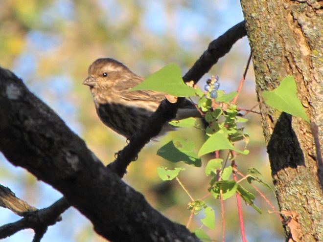
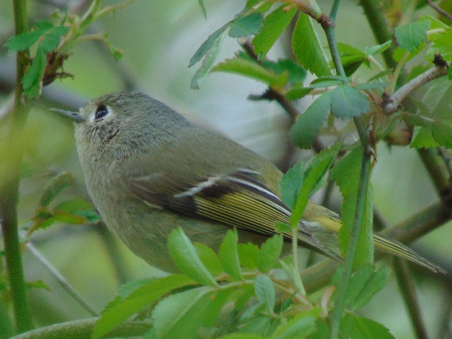
During several of the first days of October, two hundred Chimney Swifts remained in this roost until temperatures warmed from the low forties at daybreak to the upper fifties at mid-morning; then, at last, the flock ventured out in search of flying insects. When a population of birds loses its food supply or is unable to access it, that population must relocate or perish. Like other insectivorous birds, these swifts must move to warmer climes to be assured a sustained supply of the flying bugs they need to survive. Due to their specialized food source, they can be considered “specialist” feeders in comparison to species with more varied diets, the “generalists”. After returning to this chimney every evening for nearly two months, the swifts departed this roost on October 5 and did not return.A Northern Parula lingers as an October migrant along the Susquehanna. This and other specialist feeders that survive almost entirely on insects found in the forest canopy are largely south of the Susquehanna watershed by the second week of October.The Blackpoll Warbler is among the last of the insectivorous Neotropical warblers to pass through the riparian forests of the lower Susquehanna valley each fall. Through at least mid-October, it is regularly seen searching for crawling insects and larvae among the foliage and bark of Northern Hackberry (Celtis occidentalis) trees near Conewago Falls. Most other warblers, particularly those that feed largely upon flying insects, are, by then, already gone.The Blue-headed Vireo, another insectivore, is the last of the vireo species to pass through the valley. They linger only as long as there are leaves on the trees in which they feed.Brown Creepers begin arriving in early October. They are specialist feeders, well-adapted to finding insect larvae and other invertebrates among the ridges and peeling bark of trees like this hackberry, even through the winter months.Ruby-crowned Kinglets can be abundant migrants in October. They will often behave like cute little flycatchers, but quickly transition to picking insects and other invertebrates from foliage and bark as the weather turns frosty. Some may spend the winter here, particularly in the vicinity of stands of pines, which provide cover and some thermal protection during storms and bitter cold.Beginning in early October, Golden-crowned Kinglets can be seen searching the forest wood for tiny invertebrates. They are the most commonly encountered kinglet in winter.The Yellow-bellied Sapsucker, a woodpecker, is an October migrant that specializes in attracting small insects to tiny seeps of sap it creates by punching horizontal rows of shallow holes through the tree bark. Some remain for winter.The Yellow-rumped Warbler arrives in force during October. It is the most likely of the warblers to be found here in winter. Yellow-rumped Warblers are generalists, feeding upon insects during the warmer months, but able to survive on berries and other foods in late fall and winter. Wild foods like these Poison Ivy berries are crucial for the survival of this and many other generalists.American Robins are most familiar as hunters of earthworms on the suburban lawn, but they are generalist feeders that rely upon fruits like these Eastern Red Cedar (Juniperus virginiana) berries during their southbound migration in late October and early November each year. Robins remain for the winter in areas of the lower Susquehanna valley with ample berries for food and groves of mature pines for roosting.Like other brown woodland thrushes, the Hermit Thrush (Catharus guttatus) is commonly seen scratching through organic matter on the moist forest floor in search of invertebrates. Unlike the other species, it is a cold-hardy generalist feeder, often seen eating berries during the southbound October migration. Small numbers of Hermit Thrushes spend the winter in the lower Susquehanna valley, particularly in habitats with a mix of wild foods.Due to their feeding behavior, Cedar Waxwings can easily be mistaken for flycatchers during the nesting season, but by October they’ve transitioned to voracious consumers of small wild fruits. During the remainder of the year, flocks of waxwings wander widely in search of foods like this Fox Grape (Vitis labrusca). An abundance of cedar, holly, Poison Ivy, hackberry, bittersweet , hawthorn, wild grape, and other berries is essential to their survival during the colder months.Red-breasted Nuthatches have moved south in large numbers during the fall of 2020. They were particularly common in the lower Susquehanna region during mid-October. Red-breasted Nuthatches can feed on invertebrates during warm weather, but get forced south from Canada in droves when the cone crops on coniferous trees fail to provide an adequate supply of seeds for the colder fall and winter seasons. In the absence of wild foods, these generalists will visit feeding stations stocked with suet and other provisions.Purple Finches (Haemorhous purpureus) were unusually common as October migrants in 2020. They are often considered seed eaters during cold weather, but will readily consume small fruits like these berries on an invasive Mile-a-minute Weed (Persicaria perfoliata) vine. Purple Finches are quite fond of sunflower seeds at feeding stations, but often shy away if aggressive House Sparrows or House Finches are present.
The need for food and cover is critical for the survival of wildlife during the colder months. If you are a property steward, think about providing places for wildlife in the landscape. Mow less. Plant trees, particularly evergreens. Thickets are good—plant or protect fruit-bearing vines and shrubs, and allow herbaceous native plants to flower and produce seed. And if you’re putting out provisions for songbirds, keep the feeders clean. Remember, even small yards and gardens can provide a life-saving oasis for migrating and wintering birds. With a larger parcel of land, you can do even more.
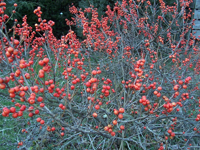
GOT BERRIES? Common Winterbery (Ilex verticillata) is a native deciduous holly that looks its best in the winter, especially with snow on the ground. It’s slow-growing, and never needs pruning. Birds including bluebirds love the berries and you can plant it in wet ground, even along a stream, in a stormwater basin, or in a rain garden where your downspouts discharge. Because it’s a holly, you’ll need to plant a male and a female to get the berries. Full sun produces the best crop. Fall is a great time to plant, and many garden centers that sell holiday greenery still have winterberry shrubs for sale in November and December. Put a clump of these beauties in your landscape. Gorgeous!
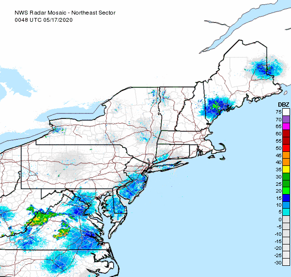
Birds on radar last evening. A dense liftoff of nocturnal migrants is indicated at radar sites across the northeastern United States. Rain showers can be seen in Virginia. (NOAA/National Weather Service image)
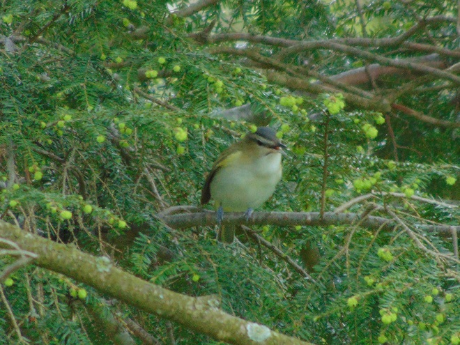
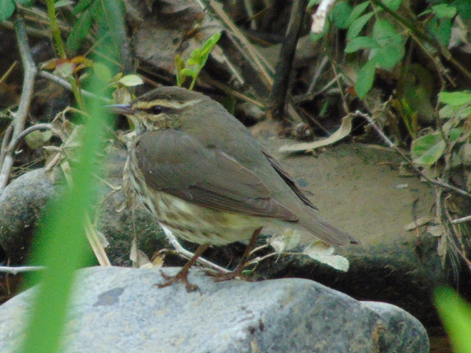
Today’s arrivals—Neotropical migrants found in a streamside thicket in the Lower Susquehanna River Watershed this morning…
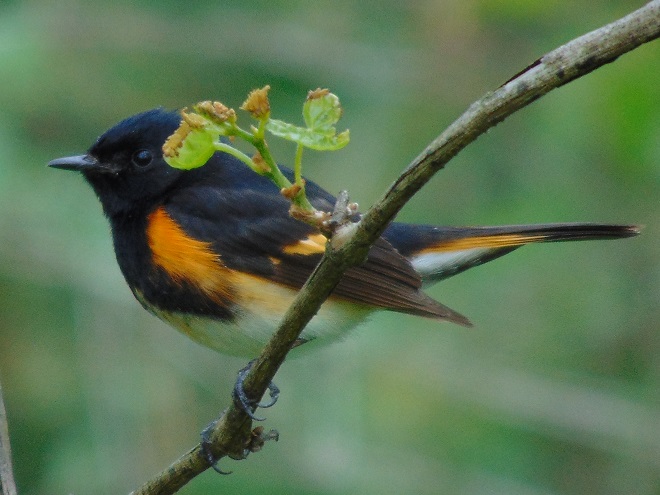
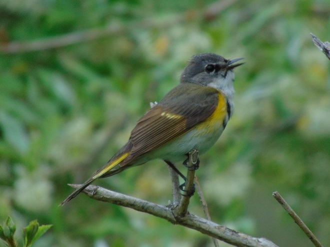
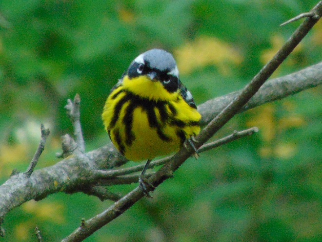
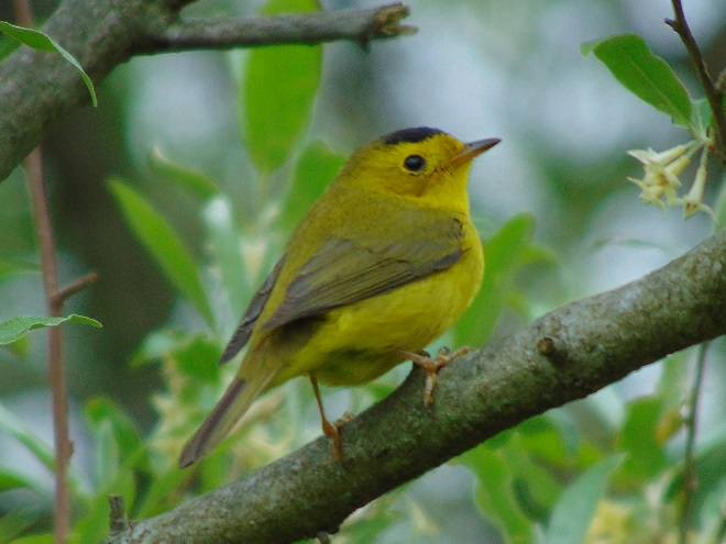
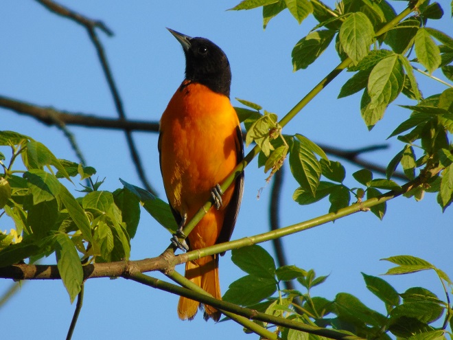
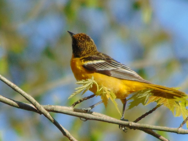
Red-eyed Vireos nest in forests throughout the lower Susquehanna valley.The Northern Waterthrush is a regularly occurring migrant that can be found in vegetated wetlands and along the backwaters of streams and rivers. Despite its drab appearance, it is classified as one of our Neotropical warbler species.The adult male American Redstart is unlike any other eastern warbler. It is easily recognized. Along the lower Susquehanna, redstarts nest in the dense understory of damp forests.The first-spring male American Redstart is similar to the female, but usually shows black markings beginning to develop on the breast and face. It is an energetic singer.In its strikingly colorful plumage, the Magnolia Warbler is a classic Neotropical bird. Locally, it is a regular migrant.The Wilson’s Warbler (Cardellina pusilla) forages in lowland thickets during its migratory stopovers. Riparian buffers along streams can provide critical habitat for this and other transient species.Baltimore Orioles continue to trickle in, creating squabbles when they enter nesting territories established by birds that arrived earlier in the month.
You need to get outside and go for a walk. You’ll be sorry if you don’t. It’s prime time to see wildlife in all its glory. The songs and colors of spring are upon us!
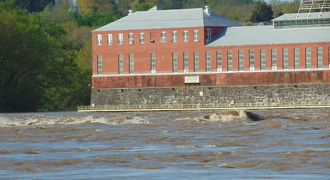
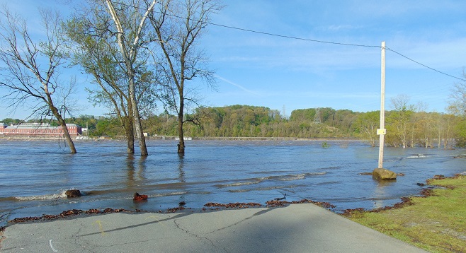
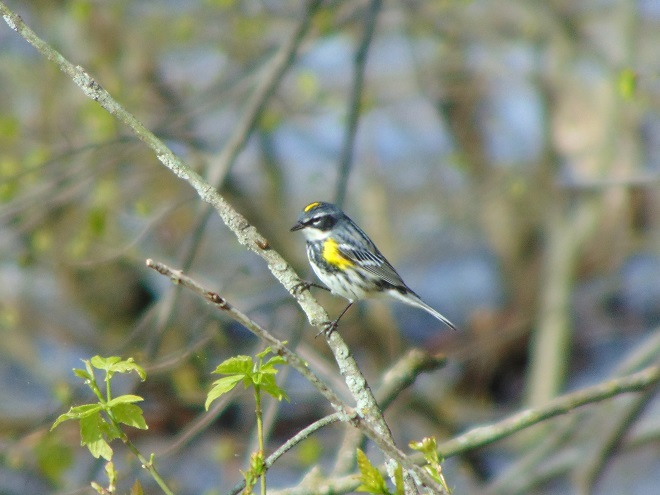
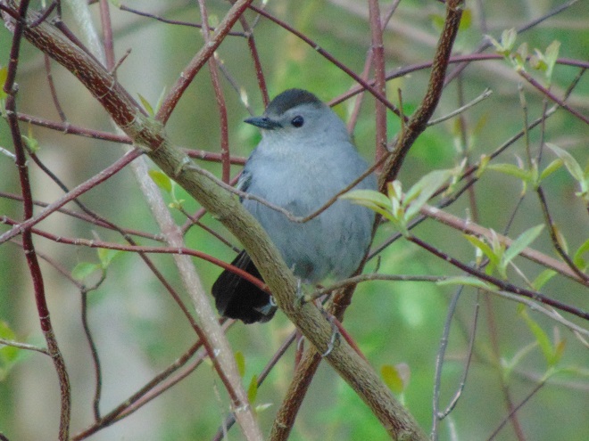
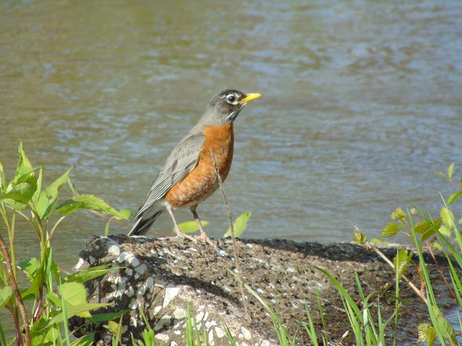
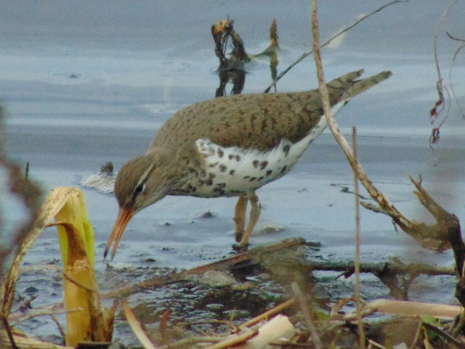
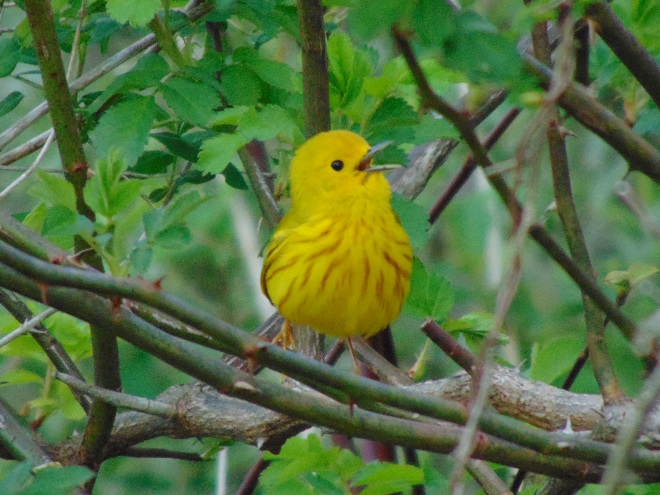
Flooding that resulted from mid-week rains is subsiding. The muddy torrents of Conewago Falls are seen here racing by the powerhouse at the York Haven Dam.Receding waters will soon leave the parking area at Falmouth and other access points along the river high and dry.Migrating Yellow-rumped Warblers are currently very common in the riparian woodlands near Conewago Falls. They and all the Neotropical warblers, thrushes, vireos, flycatchers are moving through the Susquehanna watershed right now.A Baltimore Oriole feeds in a riverside maple tree.Ruby-crowned Kinglets are migrating through the Susquehanna valley. These tiny birds may be encountered among the foliage of trees and shrubs as they feed upon insects .Gray Catbirds are arriving. Many will stay to nest in shrubby thickets and in suburban gardens.American Robins and other birds take advantage of rising flood waters to feed upon earthworms and other invertebrates that are forced to the soil’s surface along the inundated river shoreline.Spotted Sandpipers are a familiar sight as they feed along water’s edge.The Yellow Warbler (Setophaga petechia) is a Neotropical migrant that nests locally in wet shrubby thickets. Let your streamside vegetation grow and in a few years you just might have these “wild canaries” singing their chorus of “sweet-sweet-sweet-I’m-so-sweet” on your property.
If you’re not up to a walk and you just want to go for a slow drive, why not take a trip to Middle Creek Wildlife Management Area and visit the managed grasslands on the north side of the refuge. To those of us over fifty, it’s a reminder of how Susquehanna valley farmlands were before the advent of high-intensity agriculture. Take a look at the birds found there right now.
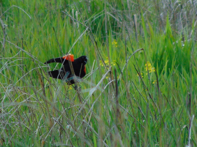
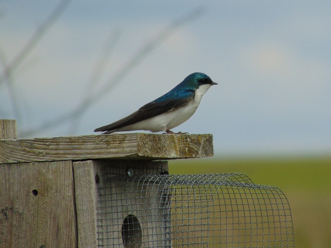
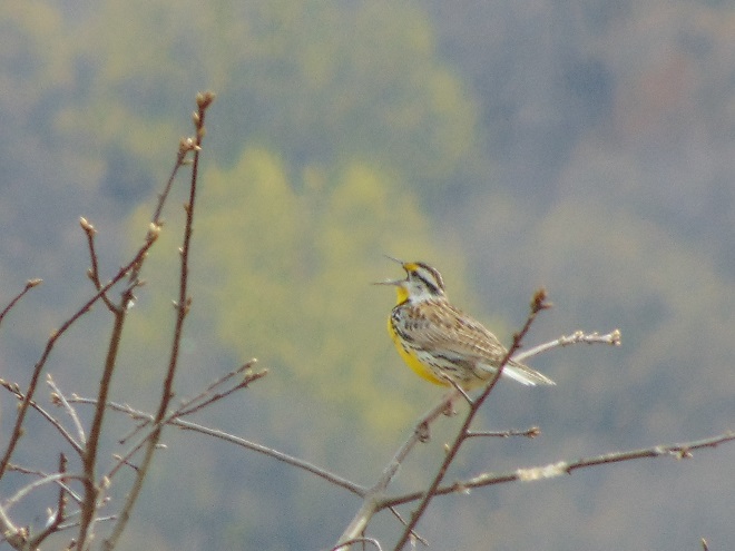
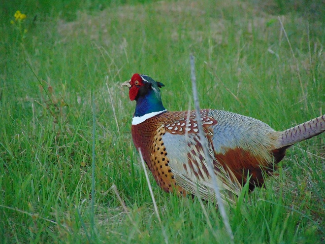
Red-winged Blackbirds commonly nest in cattail marshes, but are very fond of untreated hayfields, lightly-grazed pastures, and fallow ground too. These habitats are becoming increasingly rare in the lower Susquehanna region. Farmers have little choice, they either engage in intensive agriculture or go broke.Nest boxes are provided for Tree Swallows at the refuge.Numbers of American Kestrels have tumbled with the loss of grassy agricultural habitats that provide large insects and small rodents for them to feed upon.White-crowned Sparrows (Zonotrichia leucophrys) are a migrant and winter resident species that favors small clumps of shrubby cover in pastures and fallow land.When was the last time you saw an Eastern Meadowlark (Sturnella magna) singing “spring-of-the-year” in a pasture near your home?And yes, the grasslands at Middle Creek do support nesting Ring-necked Pheasants (Phasianus colcichus). If you stop for a while and listen, you’ll hear the calls of “kowk-kuk” and a whir of wings. Go check it out.
And remember, if you happen to own land and aren’t growing crops on it, put it to good use. Mow less, live more. Mow less, more lives.
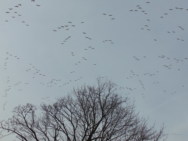
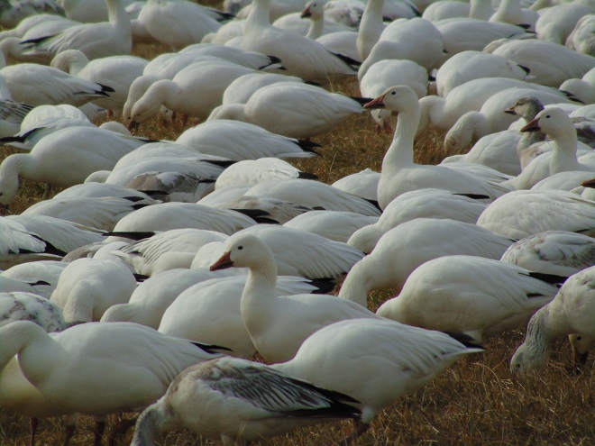
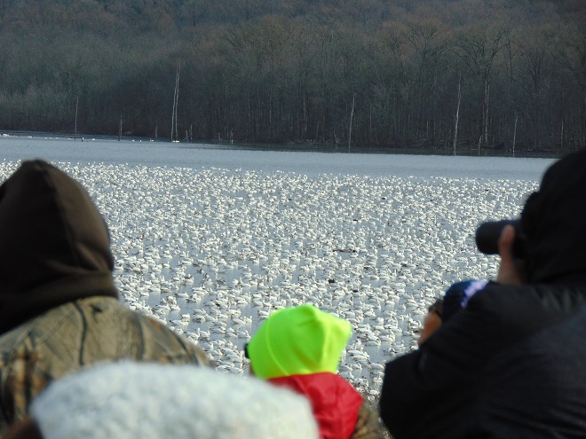
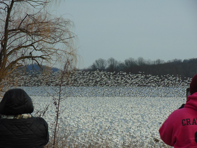
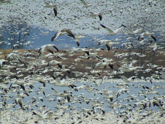
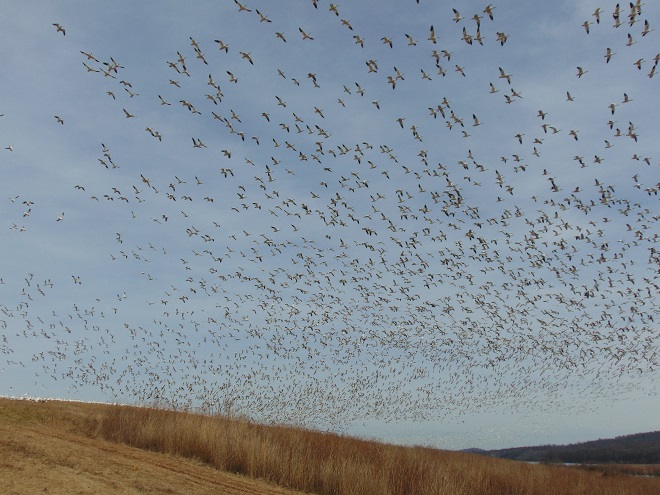
According to the most recent Pennsylvania Game Commission estimate, there are presently more than 100,000 Snow Geese at the Middle Creek Wildlife Management Area (W.M.A.) in Lancaster and Lebanon Counties. It’s a spectacular sight.
Noisy flights of Snow Geese, which can number from hundreds to thousands of birds, consist of strings of multiple V-shaped flocks. During late-February and early-March, they are a common sight as they make excursions from the lake at Middle Creek W.M.A. to feeding areas in the farmlands of the lower Susquehanna valley and back again.During the early 1990s, Snow Geese started moving away from compromised late-winter feeding areas in tidal marshes on the Atlantic Coastal Plain and began taking advantage of grazing and gleaning opportunities among grass crops (wheat, etc,), and more recently cover crops, in the almost predator-free high-intensity farming areas near the Middle Creek refuge.
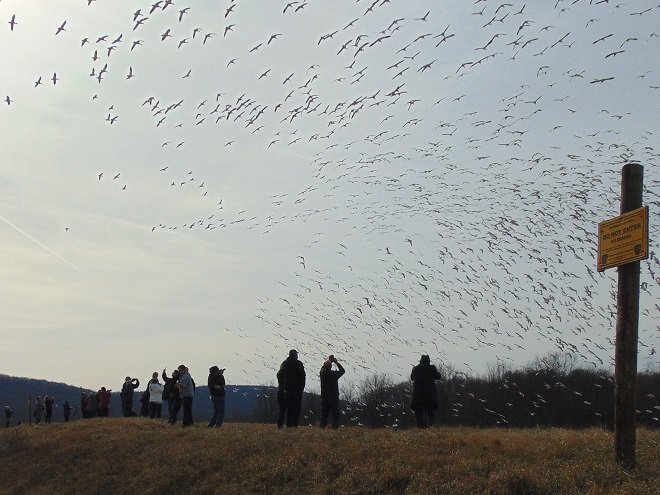
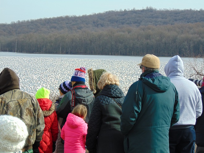
If you go to see these and other birds at Middle Creek, it’s important to remember that you are visiting them in a “wildlife refuge” set aside for, believe it or not, wildlife. “Wildlife refuge”, many would be surprised to learn, is short for “terrestrial or aquatic habitat where wildlife can find refuge and protection from all the meddlesome and murderous things people do”.
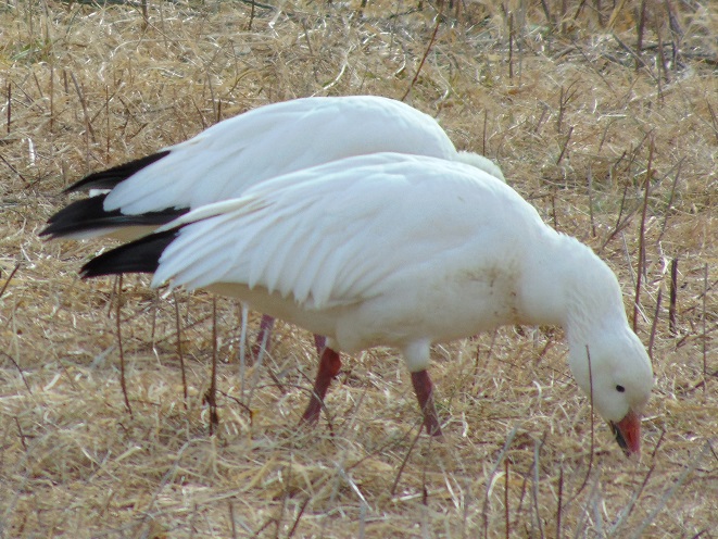
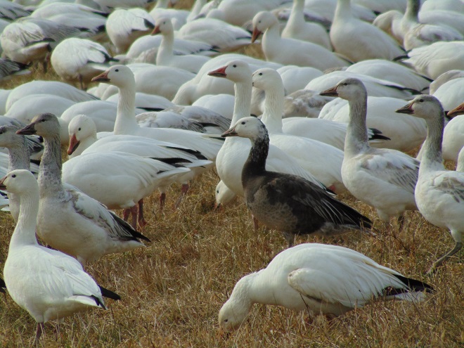
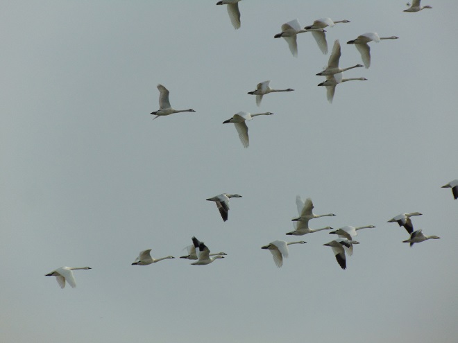
It’s not necessary to cross the well-marked boundaries of the refuge to get a better look at the geese, swans, and other wildlife at Middle Creek. Nor is it necessary to blow your motor vehicle’s horn, clap your hands, yell, or make other noises to scare the geese into flying so that you might get a good photograph. Such disturbances cause the birds to expend the energy they need to continue their journey north. They also cause the Pennsylvania Game Commission to spend funds on crowd control that might otherwise be spent on improvements to wildlife habitat.By embracing the virtue of patience, observers can get spectacular views and take great pictures from outside the refuge boundaries.Photographers who stand quietly and make no sudden movements will find that the foraging Snow Geese will often approach well within the range of most cameras. All of these pictures were taken with an inexpensive model purchased at a Walmart.Intermixed within the flocks, there are usually good numbers of gray-mottled hatch-year (juvenile) birds and often a few examples of the dark brown “Blue Goose”, a not-so-rare color morph of the Snow Goose.Observers viewing tens of thousands of Snow geese from the Willow Point observation area at Middle Creek W.M.A.There are approximately 1,500 Tundra Swans at Middle Creek W.M.A at the present time. Compare their pure white plumage and long necks with the black-tipped wings and short stocky necks of the Snow Geese accompanying them in this image.Clamoring geese let observers know that a massive lift-off may be in the making. Cameras are made ready.Away they go with a cackling roar!Sooner or latter, the geese will engulf the patient observer within one of their swirling swarms.Marvelous! Go check it out.
It was a routine occurrence in many communities along tributaries of the lower Susquehanna River during the most recent two months. The rain falls like it’s never going to stop—inches an hour. Soon there is flash flooding along creeks and streams. Roads are quickly inundated. Inevitably, there are motorists caught in the rising waters and emergency crews are summoned to retrieve the victims. When the action settles, sets of saw horses are brought to the scene to barricade the road until waters recede. At certain flood-prone locations, these events are repeated time and again. The police, fire, and Emergency Medical Services crews seem to visit them during every torrential storm—rain, rescue, rinse, and repeat.
We treat our local streams and creeks like open sewers. Think about it. We don’t want rainwater accumulating on our properties. We pipe it away and grade the field, lawn, and pavement to roll it into the neighbor’s lot or into the street—or directly into the waterway. It drops upon us as pure water and we instantly pollute it. It’s a method of diluting all the junk we’ve spread out in its path since the last time it rained. A thunderstorm is the big flush. We don’t seem too concerned about the litter, fertilizer, pesticides, motor fluids, and other consumer waste it takes along with it. Out of sight, out of mind.
Failure to retain and infiltrate stormwater to recharge aquifers can later result in well failures and reduced base flow in streams. (Conoy Creek’s dry streambed in June, 2007)
Perhaps our lack of respect for streams and creeks is the source of our complete ignorance of the function of floodplains.
Floodplains are formed over time as hydraulic forces erode bedrock and soils surrounding a stream to create adequate space to pass flood waters. As floodplains mature they become large enough to reduce flood water velocity and erosion energy. They then function to retain, infiltrate, and evaporate the surplus water from flood events. Microorganisms, plants, and other life forms found in floodplain wetlands, forests, and grasslands purify the water and break down naturally-occurring organic matter. Floodplains are the shock-absorber between us and our waterways. And they’re our largest water treatment facilities.
Why is it then, that whenever a floodplain floods, we seem motivated to do something to fix this error of nature? Man can’t help himself. He has a compulsion to fill the floodplain with any contrivance he can come up with. We dump, pile, fill, pave, pour, form, and build, then build some more. At some point, someone notices a stream in the midst of our new creation. Now it’s polluted and whenever it storms, the darn thing floods into our stuff—worse than ever before. So the project is crowned by another round of dumping, forming, pouring, and building to channelize the stream. Done! Now let’s move all our stuff into our new habitable space.
Natural Floodplain- Over a period of hundreds or thousands of years, the stream (dark blue) has established a natural floodplain including wetlands and forest. In this example, buildings and infrastructure are located outside the zone inundated by high water (light blue) allowing the floodplain to function as an effective water-absorbing buffer.Impaired Floodplain- Here the natural floodplain has been filled for building (left) and paved for recreation area parking (right). The stream has been channelized. Flood water (light blue) displaced by these alterations is likely to inundate areas not previously impacted by similar events. Additionally, the interference with natural flow will create new erosion points that could seriously damage older infrastructure and properties.
The majority of the towns in the lower Susquehanna valley with streams passing through them have impaired floodplains. In many, the older sections of the town are built on filled floodplain. Some new subdivisions highlight streamside lawns as a sales feature—plenty of room for stockpiling your accoutrements of suburban life. And yes, some new homes are still being built in floodplains.
When high water comes, it drags tons of debris with it. The limbs, leaves, twigs, and trees are broken down by natural processes over time. Nature has mechanisms to quickly cope with these organics. Man’s consumer rubbish is another matter. As the plant material decays, the embedded man-made items, particularly metals, treated lumber, plastics, Styrofoam, and glass, become more evident as an ever-accumulating “garbage soil” in the natural floodplains downstream of these impaired areas. With each storm, some of this mess floats away again to move ever closer to Chesapeake Bay and the Atlantic. Are you following me? That’s our junk from the curb, lawn, highway, or parking lot bobbing around in the world’s oceans.
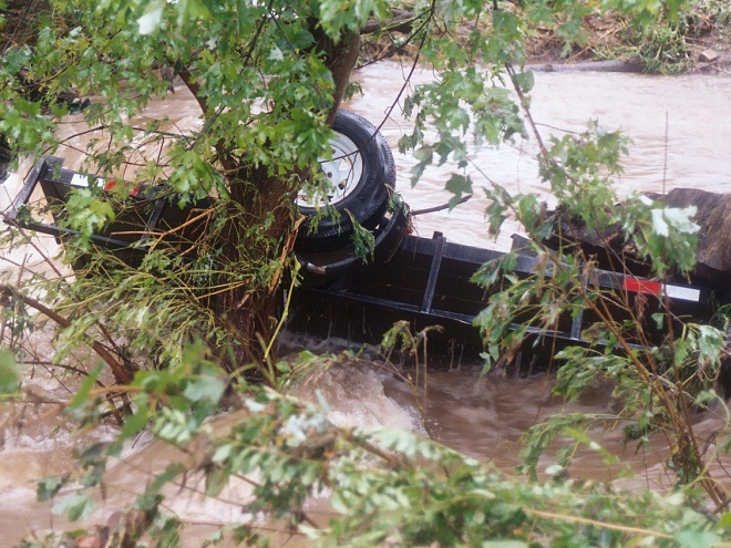
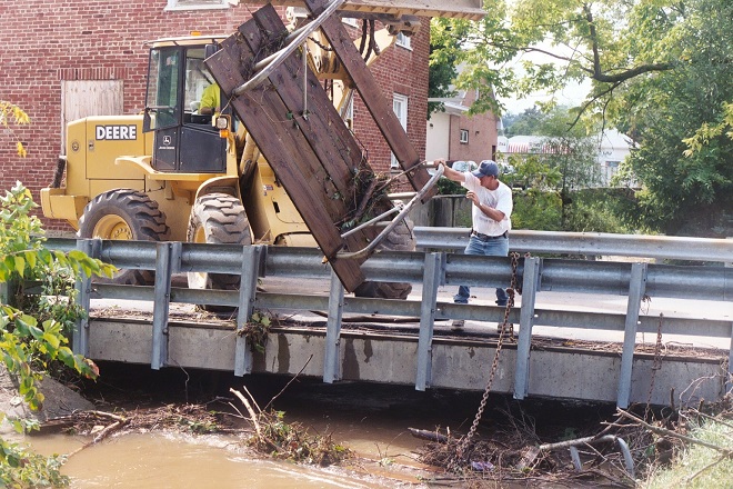
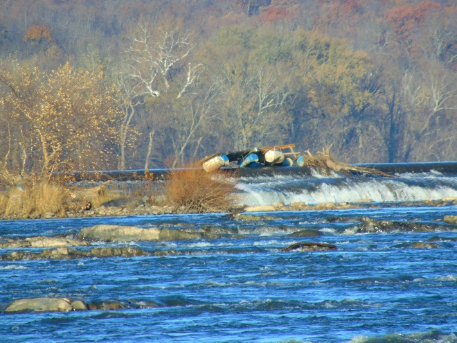
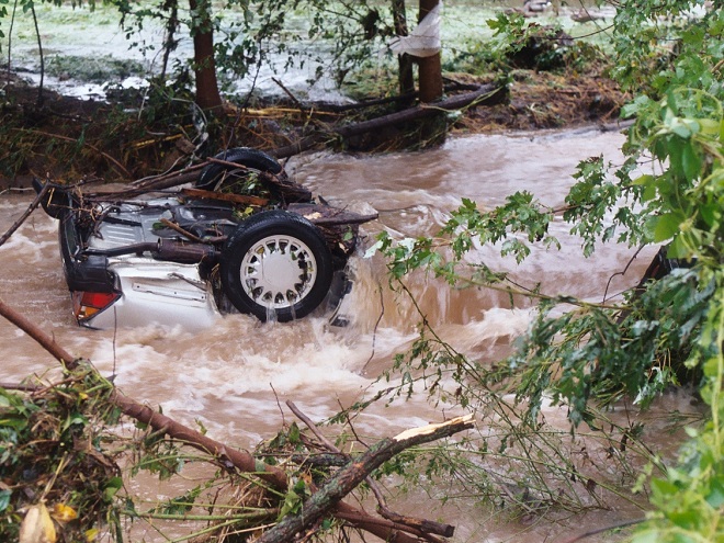
A shed, mobile home, or house can be inundated or swept away during a flood. Everything inside (household chemicals, gasoline, fuel oil, pesticides, insulation, all those plastics, etc.) instantly pollutes the water. Many communities that rely on the Susquehanna River for drinking water are immediately impacted, including Lancaster, PA and Baltimore, MD. This dumpster was swept away from a parking lot in a floodplain. It rolled in the current, chipping away at the bridge before spilling the rubbish into the muddy water. After the flood receded, the dumpster was found a mile downstream. Its contents are still out there somewhere.Floodplains along the lower Susquehanna River are blanketed with a layer of flotsam that settles in place as high water recedes. These fresh piles can be several feet deep and stretch for miles. Nature decomposes the organic twigs and driftwood to build soil-enriching humus. However, the plastics and other man-made materials that do not readily decay or do not float away toward the sea during the next flood are incorporated into the alluvium and humus creating a “garbage soil”. Over time, the action of abrasives in the soil will grind small particles of plastics from the larger pieces. These tiny plastics can become suspended in the water column each time the river floods. What will be the long-term impact of this type of pollution?Anything can be swept away by the powerful hydraulic forces of flowing water. Large objects like this utility trailer can block passages through bridges and escalate flooding problems.The cost of removing debris often falls upon local government and is shared by taxpayers.Here, a junked boat dock is snagged on the crest of the York Haven Dam at Conewago Falls. Rising water eventually carried it over the dam and into the falls where it broke up. This and tons of other junk are often removed downstream at the Safe Harbor Dam to prevent damage to turbine equipment. During periods of high water, the utility hauls debris by the truck-load to the local waste authority for disposal. For the owners of garbage like this dock, it’s gone and it’s somebody else’s problem now.Motor vehicles found after floating away from parking areas in floodplains can create a dangerous dilemma for police, fire, and E.M.S. personnel, particularly when no one witnesses the event. Was someone driving this car or was it vacant when it was swept downstream? Should crews be put at risk to locate possible victims?
Beginning in 1968, participating municipalities, in exchange for having coverage provided to their qualified residents under the National Flood Insurance Program, were required to adopt and enforce a floodplain management ordinance. The program was intended to reduce flood damage and provide flood assistance funded with premiums paid by potential victims. The program now operates with a debt incurred during severe hurricanes. Occurrences of repetitive damage claims and accusations that the program provides an incentive for rebuilding in floodplains have made the National Flood Insurance Program controversial.
In the Lower Susquehanna River Watershed there are municipalities that still permit new construction in floodplains. Others are quite proactive at eliminating new construction in flood-prone zones, and some are working to have buildings removed that are subjected to repeated flooding.
Another Wall— Here’s an example of greed by the owner, engineer, and municipality… placing their financial interests first. The entire floodplain on the north side of this stream was filled, then the wall was erected to contain the material. A financial institution’s office and parking lot was constructed atop the mound. This project has channelized the stream and completely displaced half of the floodplain to a height of 15 to 20 feet. Constructed less than five years ago, the wall failed already and has just been totally reconstructed. The photo reveals how recent flooding has begun a new erosion regime where energy is focused along the base of the wall. Impairment of a floodplain to this degree can lead to flooding upstream of the site and erosion damage to neighboring infrastructure including roads and bridges.The floodplain along this segment of the lower Swatara Creek in Londonderry Township, Dauphin County is free to flood. Ordinances prohibit new construction here and 14 older houses that repeatedly flooded were purchased, dismantled, and removed using funding from the Federal Emergency Management Agency (F.E.M.A). A riparian buffer was planted and some wetland restorations were incorporated into stormwater management installations along the local highways. When the waters of the Swatara rise, the local municipality closes the roads into the floodplain. Nobody lives or works there anymore, so no one has any reason to enter. There’s no need to rescue stubborn residents who refused advice to evacuate. Sightseers can park and stand on the hill behind the barricades and take all the photographs they like.A new Pennsylvania Turnpike bridge across Swatara Creek features wide passage for the stream below. Water flowing in the floodplain can pass under the bridge without being channelized toward the path where the stream normally flows in the center. The black asterisk-shaped floats spin on the poles to help deflect debris away from the bridge piers. (flood crest on July 26, 2018)People are curious when a waterway floods and they want to see it for themselves. Wouldn’t it be wise to anticipate this demand for access by being ready to accommodate these citizens safely? Isn’t a parking lot, picnic area, or manicured park safer and more usable when overlooking the floodplain as opposed to being located in it? Wouldn’t it be a more prudent long-term investment, both financially and ecologically, to develop these improvements on higher ground outside of flood zones?Now would be a good time to stop the new construction and the rebuilding in floodplains. Aren’t the risks posed to human life, water quality, essential infrastructure, private property, and ecosystems too great to continue?Isn’t it time to put up the white flag and surrender the floodplains to the floods? That’s why they’re there. Floodplains are for flooding.
There are two Conewago Creek systems in the Lower Susquehanna River Watershed. One drains the Gettysburg Basin west of the river, mostly in Adams and York Counties, then flows into the Susquehanna at the base of Conewago Falls. The other drains the Gettysburg Basin east of the river, flowing through Triassic redbeds of the Gettysburg Formation and York Haven Diabase before entering Conewago Falls near the south tip of Three Mile Island. Both Conewago Creeks flow through suburbia, farm, and forest. Both have their capacity to support aquatic life impaired and diminished by nutrient and sediment pollution.
This week, some of the many partners engaged in a long-term collaboration to restore the east shore’s Conewago Creek met to have a look at one of the prime indicators of overall stream habitat health—the fishes. Kristen Kyler of the Lower Susquehanna Initiative organized the effort. Portable backpack-mounted electrofishing units and nets were used by crews to capture, identify, and count the native and non-native fishes at sampling locations which have remained constant since prior to the numerous stream improvement projects which began more than ten years ago. Some of the present-day sample sites were first used following Hurricane Agnes in 1972 by Stambaugh and Denoncourt and pre-date any implementation of sediment and nutrient mitigation practices like cover crops, no-till farming, field terracing, stormwater control, nutrient management, wetland restoration, streambank fencing, renewed forested stream buffers, or modernized wastewater treatment plants. By comparing more recent surveys with this baseline data, it may be possible to discern trends in fish populations resulting not only from conservation practices, but from many other variables which may impact the Conewago Creek Warmwater Stream ecosystem in Dauphin, Lancaster, and Lebanon Counties.
So here they are. Enjoy these shocking fish photos.
Matt Kofroth, Watershed Specialist with the Lancaster County Conservation District, operates the electrofishing wand in Conewago Creek while his team members prepare to net and collect momentarily-stunned fish. Three other electrofishing units operated by staff from the Susquehanna River Basin Commission and aided by teams of netters were in action at other sample locations along the Conewago on this day.Really big fish, such as this Common Carp (Cyprinus carpio), were identified, counted, and immediately returned to the water downstream of the advancing electrofishing team. Other fish, such as the Swallowtail Shiner, Redbreast Sunfish (Lepomis auritus), Fallfish, and suckers seen here, were placed in a sorting tank.Fallfish (Semotilus corporalis) are very active and require plenty of dissolved oxygen in the water to survive. Fallfish, Rainbow Trout (Oncorhynchus mykiss), and Smallmouth Bass (Micropterus dolomieu) were quickly identified and removed from the sorting tank for release back into the stream. Other larger, but less active fish, including suckers, quickly followed.Small fish like minnows were removed from the sorting tank for a closer look in a hand-held viewing tank. This Fathead Minnow (Pimephales promelas) was identified, added to the tally sheet, and released back into the Conewago. The Fathead Minnow is not native to the Susquehanna drainage. It is the minnow most frequently sold as bait by vendors.A breeding condition male Bluntnose Minnow (Pimephales notatus).The Cutlips Minnow (Exoglossum maxillingua) is a resident of clear rocky streams. Of the more than 30 species collected during the day, two native species which are classified as intolerant of persisting stream impairment were found: Cutlips Minnow and Swallowtail Shiner.The Central Stoneroller (Campostoma anomalum) is a benthic feeder in creeks over gravel and sand.The Eastern Blacknose Dace (Rhinichthys atratulus) is found in clear water over pebble and stone substrate.The Longnose Dace (Rhinichthys cataractae) is another species of pebbly rocky streams.A juvenile Golden Shiner (Notemigonus crysoleucas). Adults lack the side stripe and grow to the size of a sunfish.A Swallowtail Shiner (Notropis procne) and a very young White Sucker (Catostomus commersonii) in the upper left of the tank.A probable Spotfin Shiner (Cyprinella spiloptera).A breeding male Cyprinella shiner, probably a Spotfin Shiner. Show-off!The Margined Madtom (Noturus insignis) is a small native catfish of pebbly streams.The Banded Killifish (Fundulus diaphanus) is adept at feeding upon insects, including mosquitos.A young Rock Bass (Ambloplites rupestris). This species was introduced to the Susquehanna and its tributaries.The Greenside Darter (Etheostoma blennioides) is not native to the Susquehanna basin. The species colonized the Conewago Creek (east) from introduced local populations within the last five years.The Tessellated Darter (Etheostoma olmstedi) is a native inhabitant of the Susquehanna and its tributaries.The stars of the day were the American Eels (Anguilla rostrata).After collection, each eel was measured and weighed using a scale and dry bucket. This specimen checked in at 20 inches and one pound before being released.Prior to the construction of large dams, American Eels were plentiful in the Susquehanna and its tributaries, including the Conewago. They’ve since been rarities for more than half a century. Now they’re getting a lift.American Eels serve as an intermediate host for the microscopic parasitic glochidia (larvae) of the Eastern Elliptio (Elliptio complanata), a declining native freshwater mussel of the Lower Susquehanna River Watershed. While feeding on their host (usually in its gills), the glochidia cause little injury and soon drop off to continue growth, often having assured distribution of their species by accepting the free ride. Freshwater mussels are filter feeders and improve water quality. They grow slowly and can live for decades.American Eels are a catadromous species, starting life as tiny glass eels in the saltwater of the Atlantic Ocean, then migrating to tidal brackish marshes and streams (males) or freshwater streams (females) to mature. This 20-incher probably attempted to ascend the Susquehanna as an elver in 2016 or 2017. After hitching a ride with some friendly folks, she bypassed the three largest dams on the lower Susquehanna (Conowingo, Holtwood, and Safe Harbor) and arrived in the Conewago where she may remain and grow for ten years or more. To spawn, a perilous and terminally fatal journey to the Sargasso Sea awaits her. (You may better know the area of the Sargasso Sea as The Bermuda Triangle…a perilous place to travel indeed!)
SOURCES
Normandeau Associates, Inc. and Gomez and Sullivan. 2018. Muddy Run Pumped Storage Project Conowingo Eel Collection Facility FERC Project 2355. Prepared for Exelon.
Stambaugh, Jr., John W., and Robert P. Denoncourt. 1974. A Preliminary Report on the Conewago Creek Faunal Survey, Lancaster County, Pennsylvania. Proceedings of the Pennsylvania Academy of Sciences. 48: 55-60.
It seems as though the birds have grown impatient for typical spring weather to arrive. The increase in hours of daylight has signaled them that breeding time is here. No further delays can be entertained. They’ve got a schedule to keep.
Thursday, March 29: Winds began blowing from the southwest, breaking a cold spell which had persisted since last week’s snowfall. Birds were on the move ahead of an approaching rainy cold front.
Friday, March 30: Temperatures reached 60 degrees at last. Birds were again moving north through the day, despite rain showers and a change in wind direction—from the northwest and cooler following the passage of the front in the late morning.
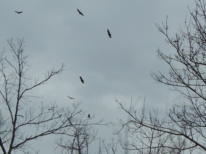
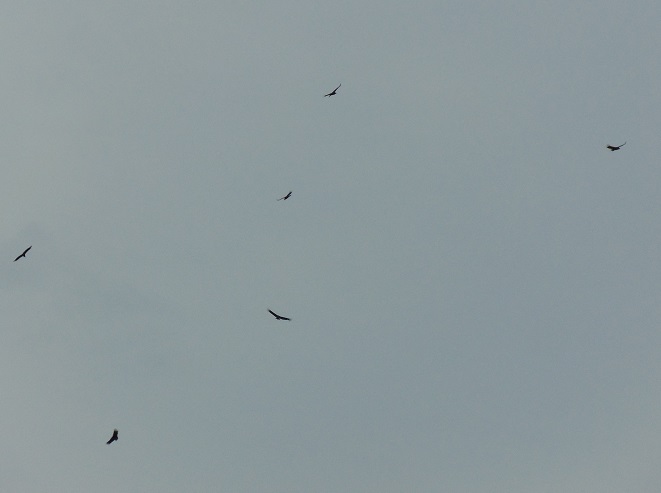
Flocks of Double-crested Cormorants followed the Susquehanna River north in numerous V-shaped flocks during the recent several days.There were Turkey Vultures by the hundreds on the way north.And nearly as many Black Vultures too.
Saturday, March 31: It was cooler, but birds were still on the wing headed north.
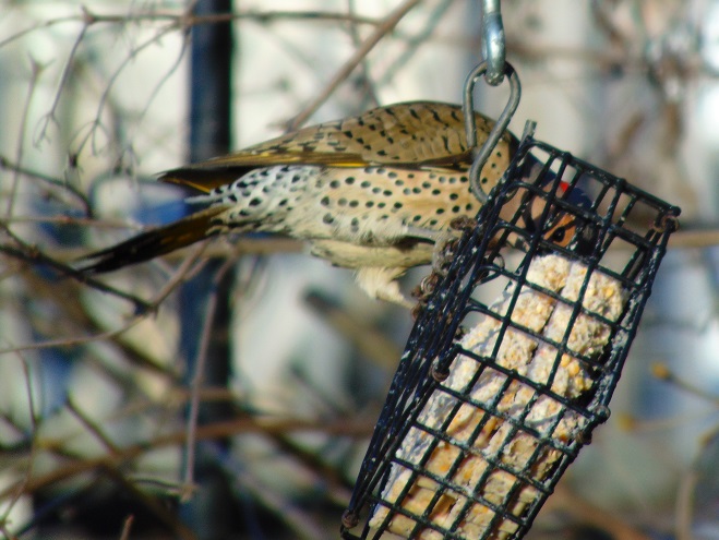
At sunrise, a migrating Northern Flicker stopped by at a suet feeder to refuel.Osprey pairs have arrived at nest sites on the lower Susquehanna.
Sunday, April 1: The morning was pleasant, but conditions became cooler and breezy in the afternoon. Migratory and resident birds began feeding ahead of another storm.
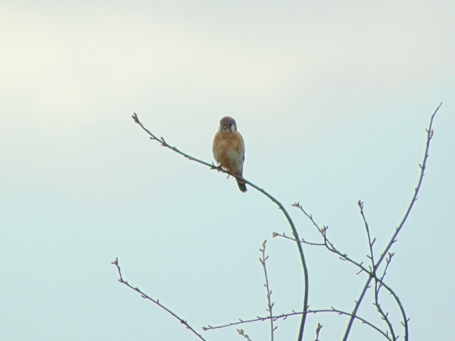
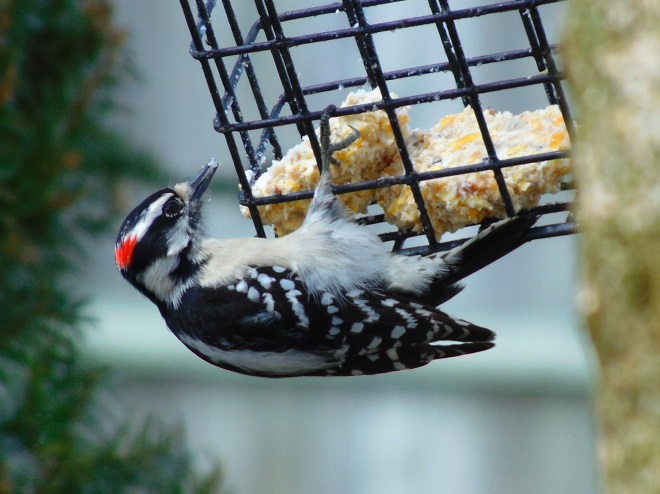
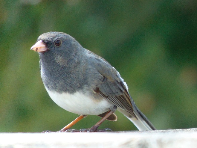
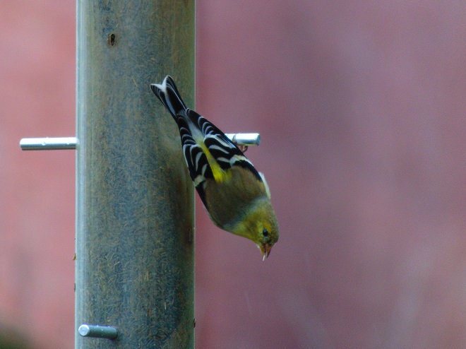
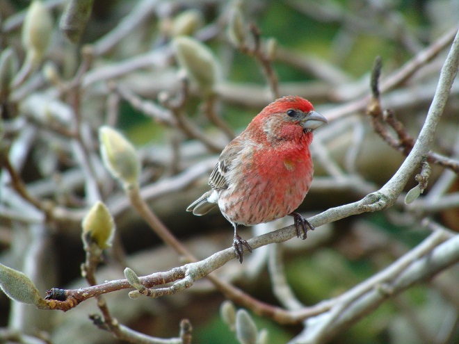
A distant flock of fast-flying Bonaparte’s Gulls (Chroicocephalus philadelphia) moves expeditiously up the Susquehanna at Conewago Falls as winds begin to pick up during the late morning. Are they hurrying to get north of the path of the forthcoming weather system?A Mourning Dove (Zenaida macroura) feeds in anticipation of a snowy night ahead.A male Downy Woodpecker devours a late-afternoon meal.This Tufted Titmouse (Baeolophus bicolor), a cavity-nesting species, is distracted by a potential new home.Dark-eyed Juncos winter in the lower Susquehanna valley. During the month of April, they will begin departing for their breeding grounds, some nesting in the mountains just to our north.Tufted Titmouse…still house hunting.A male American Goldfinch is progressing through molt into a showy breeding (alternate) plumage.A male House Finch takes a break from its melodious song to feed before the arrival of our next spring snow. His mate is already incubating eggs in a nest not far away.Northern Cardinals (Cardinalis cardinalis) feed through the late afternoon, often as the last birds out-and-about before darkness. This male remains close to his mate as she forages beneath nearby shrubs.
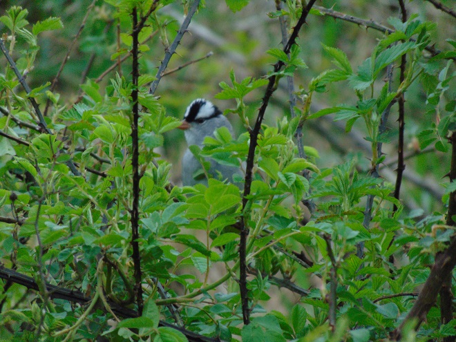
Monday, April 2: Snow fell again, overnight and through the morning—a couple of inches. Most of the snow had melted away by late afternoon.
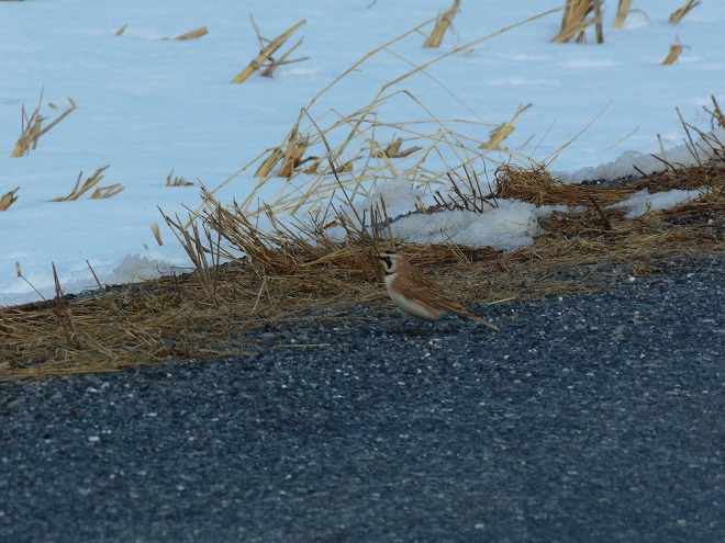
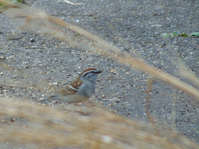
Horned Larks are plentiful in large open bare-soil (tilled) farmlands in winter, particularly near fresh manure. Their sandy-tan coloration hides them well, and they are seldom noticed unless spotted at roadside following snow storms. Horned Larks are migratory ground-nesting birds found in many sparsely vegetated habitats including tundra, parched fields and prairies, beaches, and even airports. There is a breeding population in the lower Susquehanna valley which may be increasingly attracted to favorable nesting habitat created in some no-till fields, possibly using a window of opportunity between the demise of cold-season cover crops and the ascendency of the warm-season crops to complete a brood cycle. Comparing the site selection and success rates of nesting Horned Larks under various crop management methods, including reactions to herbicide use, could be an enlightening study project for inquisitive minds. (Hint-Hint)The dainty Chipping Sparrow has arrived. This species commonly nests in small trees, often in suburban gardens.